Ertheneburg: A Medieval Elbe-Crossing Fortification in Germany
Site at a Glance
- Rating
- 4.5
- Popularity
- Very Low
- Country
- Germany
- Primary era
- Medieval
- Eras represented
- Medieval
- Civilizations
- Holy Roman Empire
- Site type
- Military
- Remains
- Castle
On this page10 sections
History
Ertheneburg is a former medieval hilltop fortification in Germany, near present-day Schnakenbek in Schleswig-Holstein, built to secure an Elbe crossing on the Old Salt Road between Lüneburg and Lübeck. First documented in 1106, it was associated with the settlement of Artlenburg on the opposite bank and was also known by the name Striepenborg.
Origins and uncertain location
The name Ertheneburg derives from the river Ertene, possibly a southern tributary of the Elbe or, more probably, an earlier branch of the river. A Count Siegfried of Ertheneburg is mentioned in 1026, and he may have been the same Siegfried recorded in the early 1130s. The identity of the count and the precise position of the medieval stronghold remain uncertain. Since 1826, the fortification on the northern bank has generally been identified as Ertheneburg, although some interpretations place the principal stronghold at Artlenburg on the southern bank.
The northern-bank fortification controlled the crossing, while the associated settlement lay at Artlenburg. Archaeological work at Artlenburg later strengthened the possibility that the main settlement and perhaps the principal stronghold stood south of the river, with the northern rampart functioning as a bridgehead that protected access across the Elbe.
Billung succession and Abodrite conflict
Duke Magnus of Saxony, the last male ruler of the Billung dynasty, died at Ertheneburg on 23 August 1106. The Billungs were a powerful Saxon ruling family, and Magnus’s death ended their rule in the duchy. Saxony passed to the future Emperor Lothar of Supplinburg, while Magnus’s daughters transmitted the family possessions to the Welf and Ascanian dynasties.
In 1129, Swinike, an Abodrite prince and son of Swentipolk, was killed at Ertheneburg. The Abodrites were a West Slavic political people based in the southern Baltic region, and the Nakonids were their ruling dynasty. Swinike’s death brought the Nakonid princely line to an end.
Henry the Lion and the destruction of the fortification
At the beginning of the Wendish Crusade in 1147, a campaign by German and Scandinavian forces against pagan Slavic peoples in the southern Baltic region, Henry the Lion crossed the Elbe at Ertheneburg with his army. In 1163 he held a regional assembly there and issued the Artlenburg Privilege, a medieval charter associated with his rule. Documents were also issued at Ertheneburg in 1169, 1170, and 1174. Henry held Bishop Udo of Halberstadt captive at the fortification, and in 1164 he appointed Count Reinold of Dithmarschen as its holder and as administrator of Sadelbande, a district in the lower Elbe region.
In 1181, while fleeing Emperor Frederick Barbarossa after rebelling against him, Henry the Lion set Ertheneburg on fire. Bernhard of Saxony later dismantled the fortification and reused its materials to build Lauenburg. Medieval references to Nova Ertheneburg, and later references to Ertheneburg after 1182, are therefore understood as names for the settlement of Artlenburg on the southern bank.
Archaeological investigation
The first excavation took place in 1923, followed by investigations in 1951 and 1979–1980. The 1951 work recovered a late-Slavic cord-impressed pottery sherd from the rampart, indicating that the earthwork was built after 1000. The later investigations produced mainly twelfth-century late-Slavic pottery and a coin from the reign of Henry the Lion. Excavations at Artlenburg in 2017 and 2018 uncovered an early- to high-medieval settlement about 400 metres southeast of the northern-bank fortification. Charcoal analysis dated associated material to 1025–1157, confirming that a settlement existed near the fortification during its period of use.
Remains
Fortification and associated settlement
Northern-bank earthworks
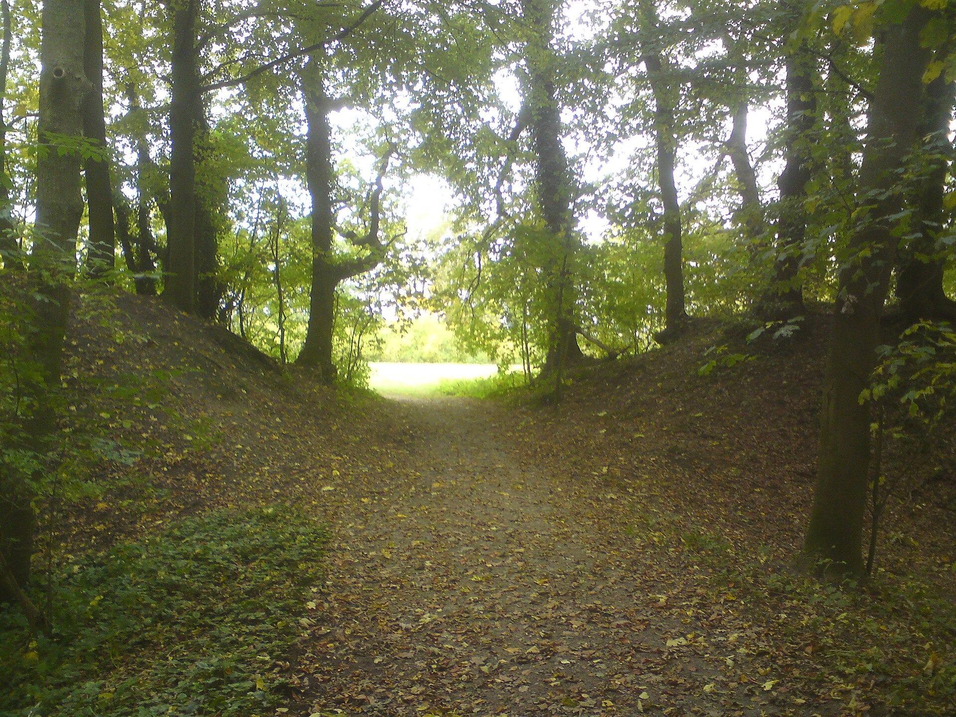
The surviving fortification is a bow-shaped ring rampart, a continuous defensive bank or wall, with its open side facing south. The southern edge descends about 30 metres in a steep slope toward the Elbe. A ditch as much as 4 metres deep follows the rampart on the north and east. On the northern side, an earthen bridge crosses the ditch and leads through an opening in the rampart into the enclosed area, which measures approximately 65 by 100 metres.
The earthworks no longer reveal the original internal arrangement. A map from 1723 shows the rampart and ditch still present in the southern sector, suggesting that the southern side later fell into the Elbe during the eighteenth century. A possible outer defensive area may have collapsed earlier. Large stones found in the river below the steep slope in the early nineteenth century may have formed the foundations of the southern defenses. Arnold of Lübeck described a stone ring wall at Ertheneburg in 1182, while the surviving site is now a former castle site, or Burgstall, represented mainly by walls and ditches.
Excavated fortification evidence
The 1923 excavation exposed large pits filled with humus, a burnt area containing daub, pottery sherds, rows of large stones laid without mortar, charcoal, gypsum, animal bones, and iron fittings and weapons. The meaning of this group of finds remains unresolved. Investigations in 1979–1980 also uncovered stone settings whose purpose could not be determined, and no house plans or post-hole traces were found.
The excavated area contained substantial Neolithic material as well as medieval remains, showing that the location was settled during the younger Stone Age and again in the medieval period. The late-Slavic pottery and the coin from Henry the Lion’s reign belong to the medieval evidence associated with the fortification.
Southern-bank settlement at Artlenburg
The 2017–2018 excavations at Artlenburg recovered material from refuse pits and wells, including Slavic and Saxon pottery, part of a globular pot, a pair of scissors, a folding knife, and half of a silver denarius belonging to Duke Bernhard I. A denarius was a small medieval silver coin. These discoveries come from the associated settlement on the southern bank rather than being identified as remains of the northern-bank rampart itself, and they support the possibility that the principal medieval settlement, or even the main stronghold, stood at Artlenburg.