Dur-Kurigalzu: A Kassite Royal and Religious City in Iraq
Site at a Glance
- Rating
- 4.3
- Popularity
- Low
- Country
- Iraq
- Primary era
- Bronze Age
- Eras represented
- Bronze Age
- Civilizations
- Babylonian
- Site type
- City
On this page16 sections
History
Dur-Kurigalzu was a Kassite royal and religious city near Baghdad in Iraq, founded in the early fourteenth century BC during the Kassite period of Babylonia. Kurigalzu I established the city and made it the capital during his reign. It remained an important urban centre after the capital moved elsewhere, and its monumental temples and palaces continued to express the authority of Kassite rulers.
Foundation under the Kassites
The Kassites were a dynasty that ruled Babylonia during the second millennium BC. Dur-Kurigalzu developed as one of their principal political and religious centres. Its name combines the Akkadian word Dur, meaning “fortress of,” with Kurigalzu, probably meaning “shepherd of the Kassites.” The practice of naming settlements with Dur had begun in the Old Babylonian period.
The city stood on an east–west limestone ridge near the confluence of the Tigris and Diyala rivers. Its fresh water came from the Euphrates through the ancient Patti-Enlil Canal, later called the Isa Canal, while the nearby Aqar Quf depression was seasonally flooded. Dur-Kurigalzu was already known beyond Babylonia by the fourteenth century BC. Its name appears in a place-name list in the funerary temple of the Egyptian pharaoh Amenophis III, built around 1351 BC.
Kurigalzu I built the city’s great ziggurat, a temple platform formed by receding terraces, and dedicated it to Enlil, a major Mesopotamian deity associated with wind, air, earth, and storms. The city’s enclosure, palaces, temples, and residential districts developed around this religious and royal centre.
Later Kassite and post-Kassite occupation
Occupation continued until the Kassite dynasty fell around 1155 BC. After that political collapse, Dur-Kurigalzu was largely abandoned and gradually lost population. The temple area remained active at least into the seventh century BC and during the Neo-Babylonian period. Smaller occupations, burials, and Arab settlements were established in parts of the site mainly between the ninth and fourteenth centuries AD.
The city later became known as Aqar Quf. Travellers and antiquarians recorded the ruins over several centuries. Bengt Bengtsson Oxenstierna visited the site in 1616. It appeared on a modern map in Edward Ives’s account of 1773, was described by Claudius James Rich in 1811, and was examined by Francis Rawdon Chesney in 1837. In the mid-nineteenth century, Henry Rawlinson identified Aqar Quf with ancient Dur-Kurigalzu.
Excavation and interpretation
Large-scale archaeological work took place from 1942 to 1945 through a joint project of the Iraqi Directorate-General of Antiquities and the British School of Archaeology in Iraq. Taha Baqir and Seton Lloyd directed the work, which examined the ziggurat, three temples, and part of a palace attributed to Kurigalzu II. More than 100 Kassite-period cuneiform tablets were recovered and entered the collection of the Iraq Museum. Some belong to the reigns of Burna-Buriash II and Kashtiliash IV.
The excavations also produced a kudurru, an inscribed stone recording a legal or property grant, designated IM 49991 and dated to the fifth year of Nazi-Maruttash. Fragments of a larger-than-life-size statue carried an exceptionally long Kassite Sumerian inscription. Further Iraqi excavations and conservation work took place around the ziggurat during the 1960s and from 1968 to 1975. Temple-area excavations continued from 1977 to 1980 under Suphi Anwar Rashid and Amire al-Khayyat.
Work at Tell Abu Shijar in 1992, 1993, and 2001 revealed mainly late Kassite remains, together with lesser Parthian and Sasanian material. The finds included painted plaster, a cylinder seal, and thirteen cuneiform clay tablets. Three tablets carried dates from the reign of Nazi-Maruttash, although the contents of the group remained unread. Italian teams also carried out photogrammetric surveys, a method that uses photographs to measure and model archaeological structures, in the late 1960s and the mid-1990s.
Recent damage and conservation
Government restoration and conservation continued over sixteen seasons in the 1960s and 1970s. Some of this work damaged original construction beneath the modern interventions. Rain, groundwater, erosion, agricultural expansion, urban encroachment, and industrial development have continued to affect the mudbrick remains. Iraqi Army trenching during the 1980s caused additional damage.
The security collapse after the 2003 US-led invasion of Iraq and the overthrow of Saddam Hussein brought further damage, abandonment, and looting. Little remained of the former administration building, museum, event stage, and restaurant. Local officials and US military authorities prepared a rebuilding plan in 2008, but it was not implemented.
Since autumn 2022, an Iraqi-Italian expedition directed by Nicolò Marchetti has carried out systematic survey and archaeological work at Aqar Quf. Systematic excavations in the palace and temple areas began in autumn 2024. A conservation project launched in spring 2025 aims to protect the mudbrick remains. Aqar Quf was added to Iraq’s Tentative List for the UNESCO World Heritage Convention in January 2025.
Remains
Dur-Kurigalzu covers about 225 hectares. During the Kassite period, an enclosure wall described as surrounding about 425 hectares contained the ziggurat, palaces, temples, and housing areas. The known sectors include the ziggurat mound, Mound A about 100 metres south of it, Tell Ahmar, Tell Abu Shijar, Tell al-Abyadh, and a private housing area. Archaeological work has identified nine temples, three palaces, and five housing areas.
Religious and monumental architecture
The ziggurat
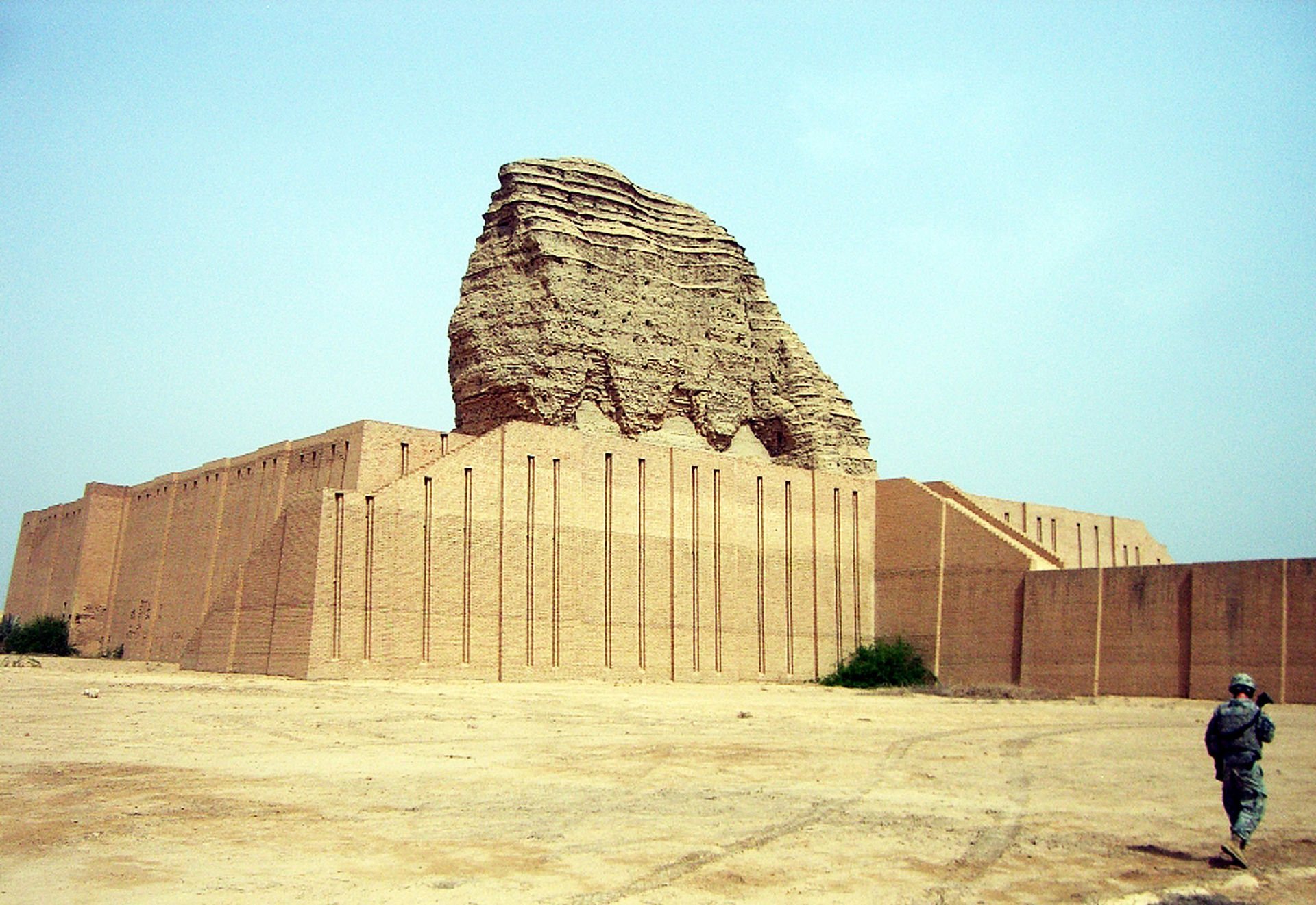
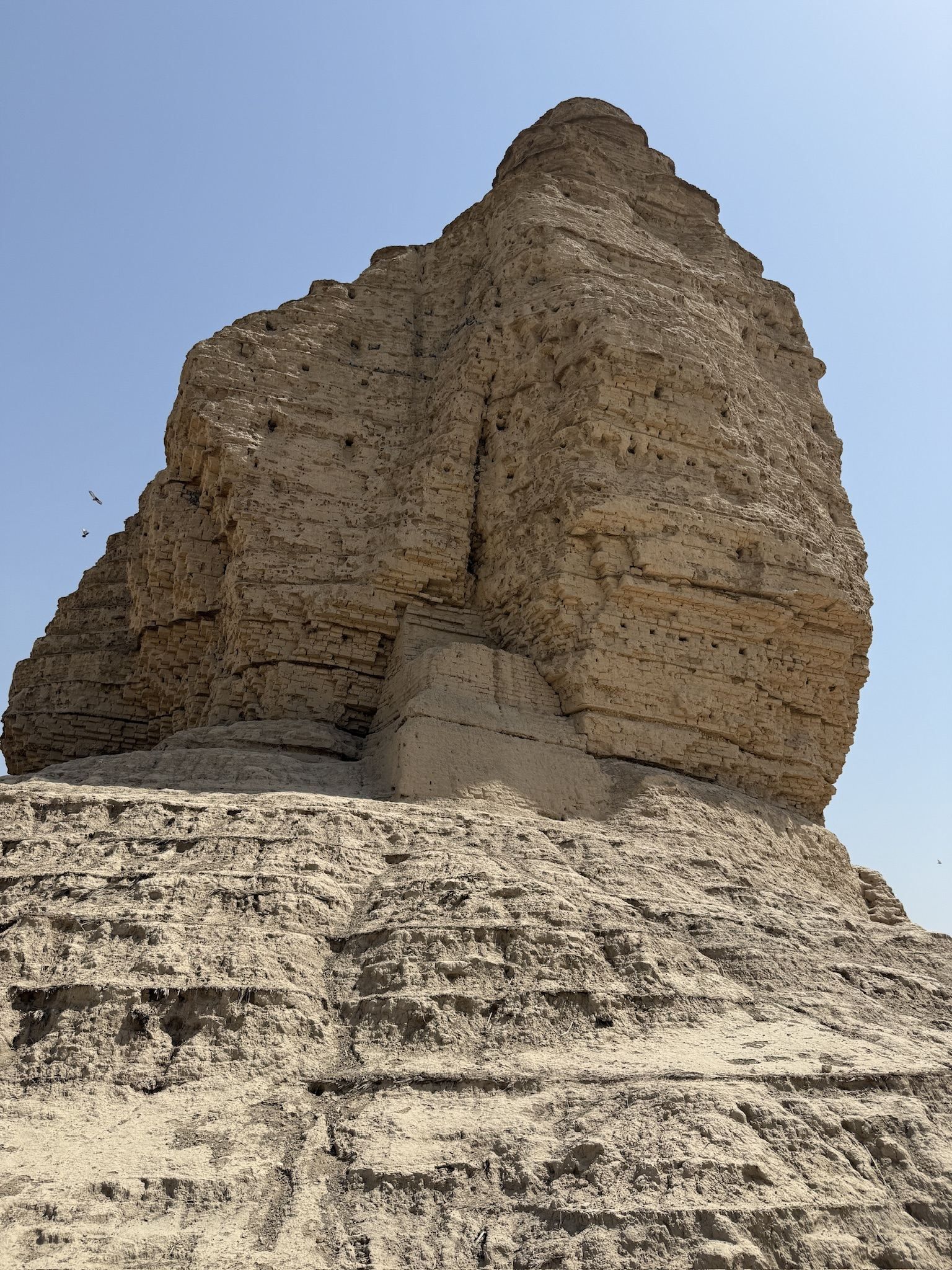
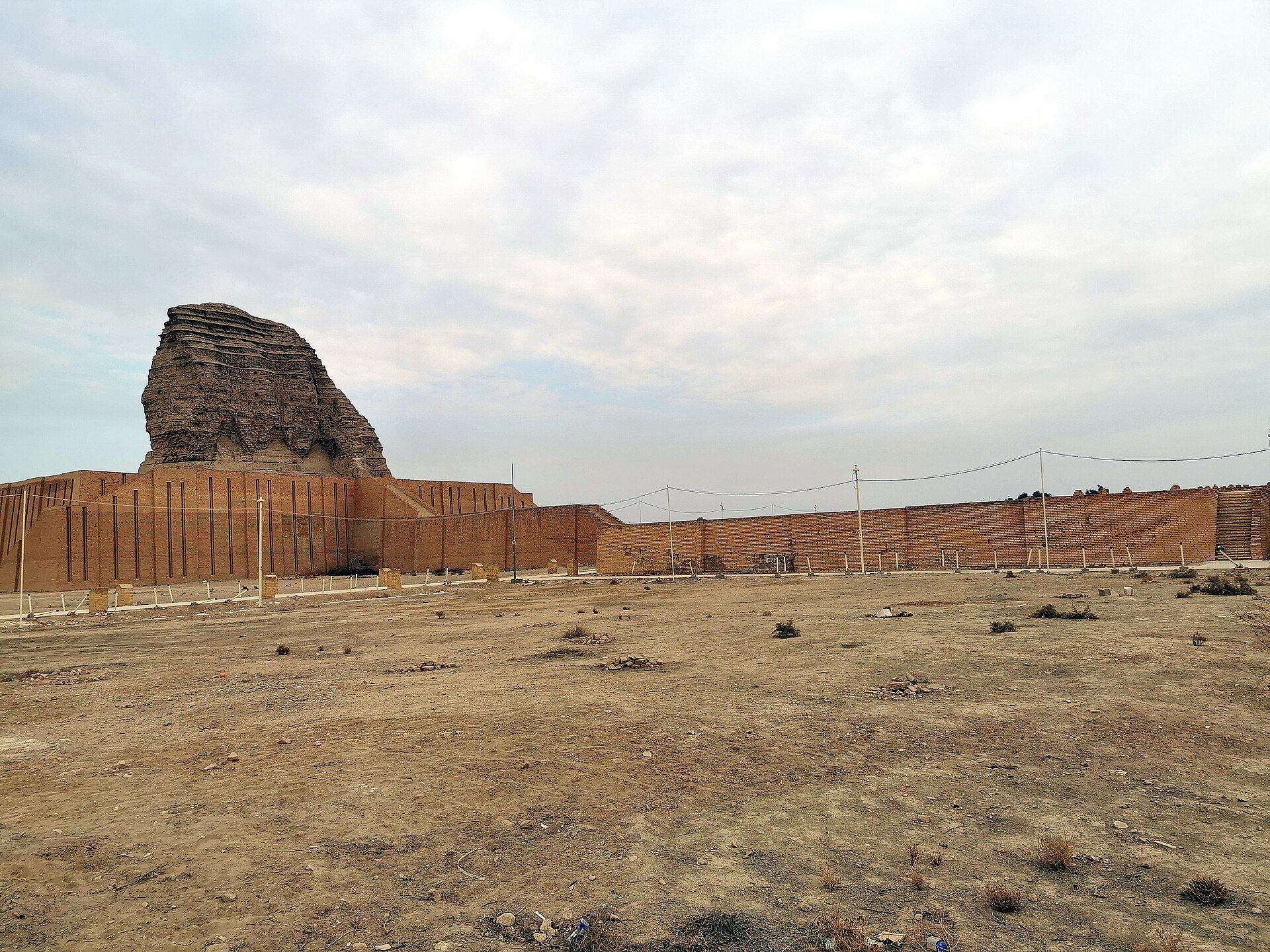
The ziggurat occupies the western part of the city and rises about 52 metres above its surroundings. Another measurement gives a height of about 57 metres, while its original height may have approached 70 metres. Its base measures approximately 69 by 67 metres, with the corners directed toward the cardinal points. The outer faces slope inward by about 9 centimetres for every metre of height and retain a stepped pattern of projections and recesses in their baked-brick facing.
Kurigalzu I built the structure in the early fourteenth century BC for Enlil. Stamped baked bricks bear the king’s name and record his dedication of the temple called E-U-GAL to the deity. The core consists of square sun-dried mudbricks strengthened by tightly bundled reed mats inserted after every seven courses. Kiln-baked brick formed the exterior walls and stairway, while bitumen was used beneath the stairway construction.
Three principal staircases led to the level of the first encircling terrace. An additional axial staircase stood at the centre of one side, facing the temple complex. Built from solid baked bricks laid in bitumen, it formed a direct approach toward the religious buildings. The surviving core is partly eroded, and the southwestern side is particularly vulnerable to rain, standing groundwater, modern construction, and further deterioration.
E-U-GAL and the other temples
E-U-GAL stood at the foot of the ziggurat stairs beside a pavement leading into a court and adjoining rooms. Its name probably means “House of the Great Lord.” The designation may have applied either to the principal temple or to the wider temple complex, because bricks bearing the name came from three temples and the ziggurat.
The other named temples were E-GASAN-AN-TA-GAL, E-SAG-DINGIR-RI-E-NE, and E-SAG-DINGIR-E-NE. Their thick mudbrick walls were heavily plastered and may preserve traces of burning. E-GASAN-AN-TA-GAL contained a small stairway leading to an altar, subsidiary courts, and a room interpreted as a kitchen. A raised rectangular compartment in that room was considered a possible oven.
A massive ruin between E-GASAN-AN-TA-GAL and E-U-GAL rises about 17 metres. Built of mudbrick and faced with baked brick, it may be the foundation of a tower whose upper sections were destroyed by flooding.
Palaces and painted interiors
The royal palace complex
A large royal palace covered approximately 420,000 square metres. Three palaces have been identified, including a palace at Tell al-Abyadh about one kilometre northwest of the main ziggurat. Two palaces bore the names Palace of the Mountain Sheep and Palace of the Stag.
The painted palace at Tell al-Abyadh
The palatial complex at Tell al-Abyadh preserves wall paintings on all four excavated levels. Their subjects and designs include human processions, groups of fruit, parallel bands, chevrons, rosettes, floral forms, and other geometric motifs. The palette included red, cobalt blue, dark blue, yellow, white, and black.
Most of the large upright paintings came from interior rooms probably used for receptions or other public activities. The greatest concentration was in Unit H, Level II, also known as the Painted Palace, which dates to the reign of Kashtiliash IV. Other painted areas decorated recesses in courtyards and spaces between rooms. Processional scenes are attributed to the reign of the later Kassite king Marduk-apla-iddina I.
Peripheral mounds and archaeological finds
Tell Abu Shijar
Tell Abu Shijar lies about one kilometre west of the ziggurat and about 500 metres southwest of Tell al-Abyadh. Its central mound measures approximately 120 by 150 metres and stands about six metres high. Agriculture and urban development have eroded much of the surrounding area.
The mound produced painted plaster fragments, a worn cylinder seal, and remains from the late Kassite, Parthian, and Sasanian periods. The cuneiform tablets found there were clay documents. Their contents remained unread, while three carried dates associated with the reign of Nazi-Maruttash.
Temple-area objects
Excavations in the temple area uncovered paving and wall bricks dedicated to Enlil and Ninlil, a major goddess associated with Enlil. Other finds included a Kassite double-jar burial, an inscribed eyestone dedicated to Enlil by Kurigalzu, and two ivory female figurines. Together with the inscribed bricks and cuneiform records, these objects connect the surviving buildings with the religious and administrative life of the Kassite city.
Enclosure and surviving mudbrick fabric
The enclosure wall was built under Kurigalzu I and later rebuilt by Kurigalzu II. Sections of the ancient boundary remain affected by modern construction and agricultural activity. Across the site, rain, groundwater, erosion, and development continue to threaten the ziggurat and other mudbrick structures, especially on the southwestern side of the great temple platform.