City Walls of Lucca: Defensive Circuits from Rome to the Renaissance
Site at a Glance
- Country
- Italy
- Primary era
- Early Modern
- Eras represented
- Classical, Medieval, Early Modern, Modern
- Civilizations
- Italian, Republic of Lucca, Roman
- Site type
- Military
- Remains
- Wall
On this page21 sections
History
The City Walls of Lucca are successive defensive circuits in Italy, first built by Roman colonists around 180 BC and later renewed in medieval and Renaissance forms. The present circuit, begun in 1544, is a Renaissance bastioned fortification. The walls reflect Lucca’s growth and its efforts to deter Florentine expansion, although the city was never besieged.
Roman and medieval defenses
Roman defenses were established when Luca was founded as a colony, a settlement under Roman authority. Emperor Probus ordered substantial repairs in the second half of the third century AD. The walls remained part of Lucca’s defenses beyond the tenth century, despite deterioration and makeshift repairs. Between 1027 and 1050, Boniface of Tuscany, a margrave who ruled the region, destroyed extensive stretches after Lucca resisted his authority.
The start of medieval rebuilding is uncertain. Work on a new circuit, connected to Roman remains, may have taken place after Boniface’s rule and before Emperor Frederick I, known as Barbarossa, arrived in Italy. A charter issued by Holy Roman Emperor Henry IV in 1081 refers to old and new walls, while a date around 1198 has also been proposed. In 1209, Holy Roman Emperor Otto IV reaffirmed protection against damage to or demolition of the defenses.
Lucca’s economic growth and its position on the Via Francigena, a major medieval route between northern Europe and Rome, encouraged settlement beyond the older circuit. By about 1200, the built-up area outside it was nearly as extensive as the area within. New boroughs developed especially to the northwest, where defenses grew in stages rather than under one coordinated plan. By the early fifteenth century, another circuit enclosed these settlements, covering an area only slightly smaller than the city’s official defenses.
The Renaissance fortification campaign
From 1491, Lucca considered modernizing its defenses as the city expanded and cannon made tall, thin medieval walls more vulnerable. The republic sought to discourage the ambitions of the Republic of Florence and, later, the Grand Duchy of Tuscany. It organized a fortification campaign in 1504, followed by technical studies from 1513; construction of the circuit that survives today began in 1544.
In May 1504 the republic established the Office of the City and State Fortifications to direct the work and oversee the walls’ later upkeep. Six elected members from influential city families served on it. The office was dissolved in 1801, and its records preserved details of construction, technical decisions, practical difficulties, and civic debate. The designs developed through successive plans, including plans produced in 1561 and 1589, the latter of which later engineers generally followed.
Building supplies arrived at Porto della Formica and travelled along the Piscilla canal, previously called Fossa Penitesa. A quarry owner on Monte Pisano had the canal built to support the construction. The campaign is generally dated to its conclusion in 1648, although its final large-scale building phase extended from 1645 to 1650. Changes to meet evolving artillery needs and building practices continued in the second half of the seventeenth century.
The defenses were intended to deter attack, and Lucca was never besieged. Its conflicts with the Duchy of Modena in the sixteenth and seventeenth centuries took place in the Garfagnana, while the republic did not enter open war with the Grand Duchy of Tuscany.
Flood, park, and changing city
The walls faced their principal test during the Serchio flood of 18 November 1812. The gates were shut and reinforced with mattresses and straw, helping to limit flooding in the city center, though water still entered and seven people died. Elisa Baciocchi, Princess of Lucca and Piombino, was carried over the walls so she could enter without the gates being opened.
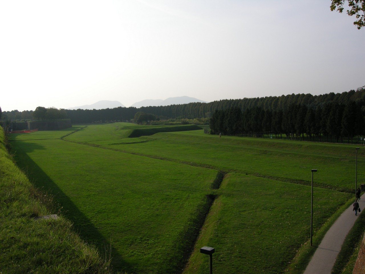
During Maria Luisa of Bourbon-Spain’s rule from 1815 to 1824, the fortifications became a public promenade and park. The open areas outside the walls were made into broad lawns, a civic use that helped preserve the moat and some of the outer defenses. The park’s public role was formally recognized in 1840, when a café was built on Baluardo Santa Maria.
The walls contained the city until the nineteenth century, and building immediately beyond them remained relatively limited. Lucca’s wider settlement also included boroughs along roads leading out from the gates and rural residential clusters, some within the area known as the six miles. From the nineteenth century onward, proposals for additional entrances prompted debate over security and easier connections with the surrounding territory.
Remains
The surviving defenses preserve several successive circuits around the historic center. The Renaissance perimeter is the most complete: a system of wall lengths and projecting bastions (defensive platforms), built with earth and plant material inside brick and stone facings. Roman and medieval alignments and structures can also be traced through streets, surviving wall sections, gates, and elements incorporated into later construction.
Roman circuit
Alignment and street plan
The commonly traced Roman rectangle follows Via San Giorgio to the north, Corso Garibaldi to the south, Via Galli Tassi and Via della Cittadella to the west, and Via della Rosa and Via dell’Angelo Custode to the east. Within it, the former Roman military-camp plan is reflected in the present north–south route of Via Veneto, Via Calderia, and Via degli Asili, and the east–west route of Via San Paolino, Via Roma, and Via Santa Croce. Their meeting point is identified with the forum, the central public square, at Piazza San Michele, where the church of San Michele in Foro stands.
The eastern, northern, and southern alignments are comparatively well established, but the western course remains uncertain. The circuit appears to have had an irregular outline, projecting farther to the northwest and bending inward at the southwest. Its shallow northeastern curve may have followed the Serchio, which served as a ditch there; the stepped western alignment is also uncertain. The southwest side included Porta Vecchia di San Donato, named in 1235.
Surviving Roman fabric
Short sections identified as Roman walls are incorporated into later buildings, including inside Santa Maria della Rosa church and in the basement of Baluardo San Colombano. The few raised sections may include later rebuilding as well as original Roman work.
Medieval circuits
Expanded perimeter and borough defenses
The medieval circuit departed from the Roman rectangle to follow the city’s expansion. It reached north to Via dei Carrozzieri, south to the present Porta San Pietro, west to Piazzale Verdi, and east to Via San Nicolao. A long northern stretch reused and updated Roman walls. In the northwest borough area, early defenses also followed uneven ground and local canals, using simple earthworks and wooden barriers. By the early fifteenth century, a lower wall enclosed the boroughs.
Wall construction and gates
The medieval walls were about 2.45 metres thick. Their rubble-and-mortar core had carefully squared stone facing on the outside and a less costly brick layer within. The lowest three exterior courses projected slightly, by about a centimetre per course, to improve stability. About 24 semicircular towers, open toward the city and built into the circuit using the same method, formed part of the defenses; some were later absorbed into Renaissance earthworks.
Porta dei Borghi and Porta San Gervasio survive as gates from this earlier circuit, along with smaller passages. Both principal gates are dated to 1198. The borough defenses also had water-control and defensive ditches; the lower wall built around them was about seven metres high and faced mainly in brick.
Renaissance circuit
Overall form and construction
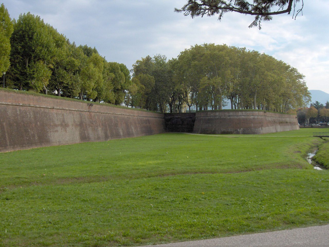
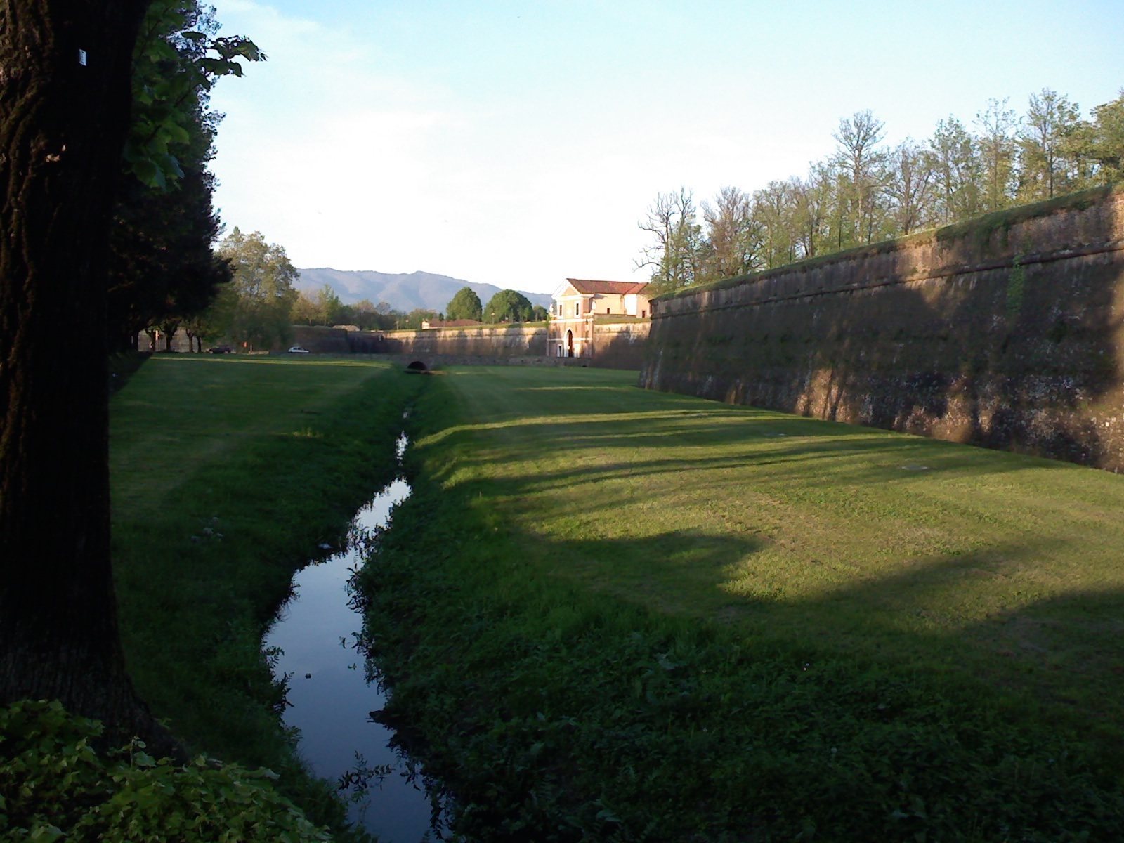
The Renaissance perimeter measures 4,223 metres around and is about 12 metres high. It has 12 curtain walls, the stretches between projecting bastions, and 11 bastions. The circuit is described as intact and is among Europe’s best-preserved Renaissance bastioned defenses.
Its construction enclosed a mass of pressed earth, plant matter, and living vegetation within brick and stone facing. The earth and vegetation helped drain the ground, reduce slippage, and spread structural loads. Builders selected and prepared the plant materials carefully, but poor-quality organic matter contributed to several construction-stage collapses. In a 1663 report, Giovan Battista Orsucci praised the way the fortifications incorporated vegetation and described their ecological qualities.
Northern front
The northern defenses are lighter because the nearby Serchio made a formal siege difficult. Bastions are spaced farther apart there, and a relatively inexpensive platform takes the place of a large central bastion. The circuit also reuses a long, irregular stretch of thirteenth-century wall. Its white stone contrasts with the brickwork of the Renaissance sections.
Gates and bastions
Principal entrances
The six principal gates are Porta Santa Maria, dated to 1592 and opening onto Piazza Santa Maria; Porta San Pietro, dated to 1565 and facing the railway station; and Porta San Donato, dated to 1629 at Piazzale San Donato. Porta San Pietro was also called the steam gate because of the steam trains. Porta Elisa, dated to 1811, stands on the route of Via Elisa; it provided an entrance on the Florence-facing side, which had previously been kept without access for strategic reasons. Porta Sant’Anna opened in 1911 at Piazzale Verdi, and Porta San Jacopo alla Tomba was added in the twentieth century.
Earlier gates and military openings
Other older gates remain visible within the Renaissance perimeter. Antica Porta San Donato, dated to 1590, stands in Piazza San Donato. Porta San Gervasio is on Via del Fosso at its junction with Via Elisa, and Porta dei Borghi is at the end of Via Fillungo toward Piazza Santa Maria. The original defensive arrangement also included smaller openings for the garrison. These allowed troops to reach outer defenses for sorties and counterattacks and were bricked up on the outside; many have since been reopened as pedestrian passages. A separate opening served a narrow-gauge railway that is no longer in service.
Bastions and associated buildings
The named bastions include San Pietro, the last to be built; San Salvatore, which suffered structural problems attributed to poor material choices; Santa Maria, completed in 1557; and San Paolino. San Donato incorporated part of a medieval wall and collapsed in November 1589 after heavy rain and the use of unsuitable materials. Its construction had required demolition of the old church of San Donato in 1513, prompting discontent among church authorities; the church was later rebuilt as San Paolino.
Park and structures along the walls
Moat and promenade
The moat survives without its counterscarp, the outer face of a defensive ditch opposite the main wall. It and some exterior defenses form part of the public green space around the historic center. Hundreds of trees were planted along the walls both to enhance the promenade and to supply fuel and repair materials in case of siege. The tree-lined route along the top extends for more than four kilometres.
Buildings and later uses
Structures associated with the circuit include Casermetta San Pietro, Casermetta San Salvatore, Casermetta San Regolo, Casermetta San Colombano, Casermetta Baluardo San Paolino, Casermetta San Donato, Casermetta Santa Croce, and Casermetta San Frediano, as well as Tettoia San Colombano, Castello Porta San Pietro, and Castello Porta San Donato Nuova. Other named buildings include Casa del Boia, Villaggio del Fanciullo, Casermetta Daziaria, and Casermetta Santa Maria. Several were military buildings; some have been repurposed and others are abandoned. Casa del Boia houses a museum, Villaggio del Fanciullo is a community for minors, Casermetta San Donato houses the Lucca Mint, and Castello Porta San Donato Nuova houses the Casa della Memoria e della Pace.
The neoclassical Caffè delle Mura replaced Casermetta Santa Maria. On Baluardo Santa Maria, a statue of Vittorio Emanuele II, the first king of unified Italy, was installed in 1885 after the café was moved back to make room. Baluardo San Pietro later served as a Royal Army barracks and housed the fire brigade; an exterior gate there was opened toward Campo di Marte.