Çatalhöyük: A Neolithic Settlement in Türkiye


Site at a Glance
- Rating
- 4.6
- Popularity
- Medium
- Country
- Turkey
- Primary era
- Stone Age
- External website
- Open
- Eras represented
- Stone Age
- Civilizations
- Unclassified
- Site type
- Domestic
On this page13 sections
History
Çatalhöyük is a large Neolithic and Chalcolithic settlement in Türkiye, built by communities of the later Stone Age from around 7400 BC and occupied until about 5600 BC. It developed through successive phases of permanent settlement, cultivation, animal management, craft production, and ritual activity on the Konya Plain. The site helped establish central Anatolia as an important region in the development of Neolithic village communities, rather than merely a recipient of innovations from the Levant and Mesopotamia.
Neolithic and Chalcolithic occupation
Çatalhöyük consists of two principal mounds separated by an extinct channel of the Çarşamba River. The Eastern Mound was occupied approximately from 7100 to 5900 BC, while the Western Mound was used approximately from 6000 to 5600 BC. The Western Mound represents an Early Chalcolithic settlement, a period when copper use developed alongside established stone technologies. Earlier estimates placed the settlement within a shorter period, but the latest cited chronology extends from approximately 7400 to 5600 BC.
The settlement grew through repeated rebuilding. Houses were constructed over collapsed or demolished earlier buildings, creating a tell, an artificial mound formed by accumulated occupation. Around 17 metres of archaeological deposits developed in this way. Eighteen successive settlement layers were exposed during the first major excavations, while the wider sequence represents roughly many centuries of changing domestic, economic, and ritual practices.
People cultivated einkorn and emmer wheat, barley, peas, common beans, lentils, and grass pea. They gathered wild almonds, acorns, pistachios, and other fruits, and some fields may have been located about 10 kilometres from the settlement. Sheep and goats were domesticated, while cattle and horses were generally wild according to later interpretations. Hunting, fishing, bird collecting, and the gathering of eggs continued alongside cultivation and animal management.
Çatalhöyük’s surroundings offered clay but relatively few other raw materials. Obsidian, flint, timber, and marine shells came from distant regions. Obsidian was obtained from Göllü Dağ and Nenci Dağ in southern Cappadocia, about 190 kilometres to the northeast. Pine and juniper may have come from the Taurus Mountains, flint from Syria, and shells from the Mediterranean and Red seas. These materials show exchange over long distances, although the role of obsidian in the settlement’s economy remains debated.
Researchers have proposed that access to Cappadocian obsidian influenced Çatalhöyük’s economy, and some have suggested that exchange in the volcanic glass was its principal source of income. Finds of earlier obsidian in the southern Levant and along the Euphrates indicate that eastern settlements were not dependent on Çatalhöyük for their supplies. The evidence therefore supports wide exchange networks without establishing a single economic model for the settlement.
Social and ritual life
Çatalhöyük has often been interpreted as a large village or proto-urban settlement rather than a city with a fully developed administrative system. Houses show limited differences in size, and evidence from soot on ribs, diet, burial placement, and skeletal remains indicates broadly similar status for men and women. Other studies suggest that social organization was more complex and may have become less egalitarian over time. Clay seals from later layers may have marked ownership, although their precise function is uncertain.
Families appear to have maintained and repaired their own dwellings. Burials were placed beneath house floors, and human skulls were sometimes separated from bodies, coated with plaster to model facial features, and painted with ochre. Male and female skull burials occurred in approximately equal numbers. The practice points to a skull-related ritual whose meaning remains uncertain. Many children were buried at the site, and some children’s bones show signs of anemia probably related to malnutrition. Dental analysis indicates that people buried beneath the floor of one house were not necessarily biologically related.
Burials, murals, animal-head sculptures, and figurines reveal a rich symbolic life. James Mellaart interpreted elaborately decorated rooms as shrines and associated the settlement with a bull cult and a Mother Goddess. Maria Gimbutas later developed a broader theory of Çatalhöyük as a peaceful, egalitarian, female-centred society destroyed by patriarchal invaders. Later research, including Ian Hodder’s work, has not supported a straightforward matriarchal interpretation or the existence of a single Mother Goddess tradition. Domestic activity in decorated rooms also shows that ritual and everyday life were closely connected within the houses.
The reasons for choosing the location and later leaving it remain uncertain. One proposed explanation links abandonment to environmental degradation caused by excessive timber use, but evidence from later layers challenges that interpretation because the relevant construction method was no longer being used. The settlement was abandoned before the beginning of the Bronze Age, after which the mounds experienced later, more limited episodes of occupation.
Discovery and archaeological research
David French, Alan Hall, and James Mellaart first identified Çatalhöyük on 10 November 1958 during a British Institute of Archaeology at Ankara survey for early settlements on the Konya Plain. Pottery and obsidian objects found that day showed that the mound was a major Neolithic site. Mellaart directed large excavations for four seasons between 1961 and 1965. More than 200 buildings were exposed, revealing the settlement’s extensive sequence and its importance for understanding Neolithic cultural development in central Anatolia.
Mellaart’s excavation permit was cancelled by Turkey’s Department of Antiquities in 1965 after the Dorak affair. Authorities suspected his involvement in the removal of Bronze Age finds after he published drawings of allegedly important objects. The woman who was said to have shown him the objects and the objects themselves were never located.
Research resumed in 1993 under Ian Hodder. The renewed project used micromorphological analysis, which examines tiny samples of sediment and building material under a microscope, together with other scientific and digital methods. It also involved local residents and proceeded more slowly than the earlier excavations. Hodder’s excavations ended in 2018, while later teams, including work directed by Ali Umut Türkcan, have continued research on the site. The 2006 international and interdisciplinary excavation season involved 230 participants, with teams investigating both mounds.
In 2025, a team led by Arkadiusz Marciniak reported a mortuary building known as the “House of the Dead” or “Spiritual House.” It contained the remains of 20 individuals beneath its floor, along with a larger painted ceremonial structure supported by 14 platforms and a smaller plastered structure. These buildings were interpreted as evidence for mortuary or ritual use.
Çatalhöyük was inscribed on the UNESCO World Heritage List in 2012 during the organization’s 36th session as the Neolithic Site of Çatalhöyük. The designation recognizes the settlement as a cultural World Heritage property. It also reflects the site’s value for understanding the formation and transformation of early settled communities, while later discoveries elsewhere have qualified earlier claims that Çatalhöyük was the world’s oldest city, earliest farming settlement, or largest settlement of its time.
Remains
Çatalhöyük occupies two mounds on the Konya Plain, the bed of a dried Pleistocene lake, at slightly more than 1,000 metres above sea level. The Çarşamba River originally flowed between the mounds and supplied fresh water in the dry climate. The Eastern Mound covers approximately 12.5 hectares and rises about 20 metres above the surrounding plain. The Western Mound is about 400 metres in diameter, covers roughly 8.5 hectares, and rises about 7.5 metres. Only about 5 percent of the settlement has been excavated.
Settlement layout and construction
The mounds are formed from successive layers of houses built over earlier structures. This accumulation created the tell and preserved a deep sequence of buildings, surfaces, refuse deposits, burials, and discarded objects. The houses were packed together in a honeycomb-like arrangement, with movement probably taking place across the roofs. Open spaces between buildings served as refuse areas or middens containing animal and plant waste, food remains, ash, pottery, figurines, beads, and other discarded material. Some deposits have been interpreted as human feces, and the spaces may have served as toilets, although this interpretation remains uncertain.
Domestic houses
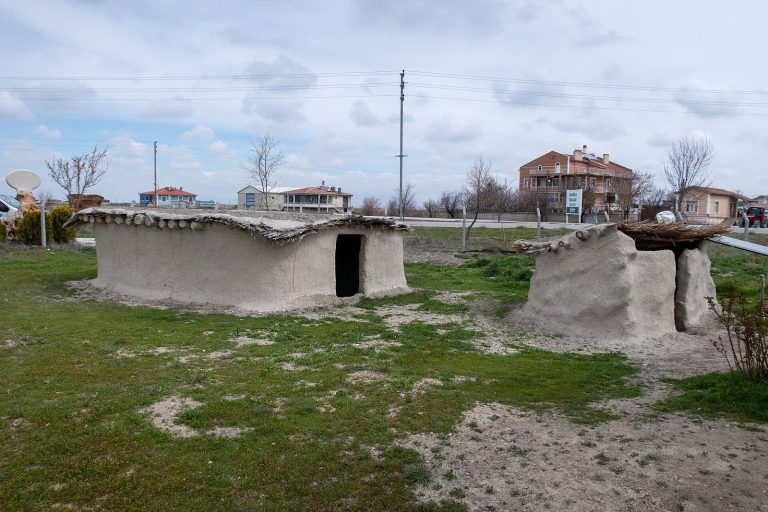
Most houses were built from mudbrick and clay with wooden roof beams. Their estimated usable life was about 70 years, and fresh clay was added to their surfaces each year. Walls, roofs, interiors, and raised platforms were plastered, often with polished alabaster or smooth plaster. A typical house covered about 23 square metres, although recorded examples range from 11 to 48 square metres. The single-storey buildings generally accommodated five to ten people, and no recorded house contained more than eight beds.
Most houses were entered through roof openings reached by ladders or stairs from inside and outside. The opening also provided the principal ventilation route, allowing fresh air to enter while smoke from hearths and ovens escaped. Some excavated buildings also had side doors. The principal room contained a hearth or oven, a fireplace, benches, low raised platforms, and food-storage containers. Cooking installations and the main roof opening were generally placed on the southern side, while small storage rooms were reached through low openings in the walls.
Domestic activities included cooking, storage, craft production, and the manufacture of figurines, beads, and other objects. Some larger rooms had elaborate wall paintings, although their particular purpose remains uncertain. Houses also served as burial places, with human remains placed beneath floors, especially under hearths, platforms, and other raised interior areas. One house contained the remains of 68 people. Bodies were tightly flexed and were often placed in woven baskets or wrapped in reed mats. Disarticulated skeletons, meaning bones no longer joined in their original anatomical arrangement, suggest that some bodies may first have been exposed before their bones were collected and buried.
Mortuary structures
The 2025 House of the Dead contained 20 individuals beneath its floor. It was associated with a larger painted ceremonial structure supported by 14 platforms and a smaller plastered structure. Together, these features were interpreted as a mortuary or ritual complex within the settlement. Grave offerings from Çatalhöyük included precious and semiprecious stones, weapons, textiles, and wooden vessels, linking burial practices to the material life of the houses.
Painted and sculpted interiors
About one-third of the houses were more elaborately decorated than others. Their features included cattle heads fixed to walls or low platforms, with some arranged in rows. A room dating to approximately 6200 BC contained four human skulls positioned behind cattle heads on the walls. Later excavations found similar rooms in several parts of the Eastern Mound, and micromorphological analysis identified domestic activities within them. These results place decorated buildings within the wider life of the settlement rather than in an exclusively religious quarter.
Wall paintings and reliefs
Paintings and reliefs covered interior and exterior surfaces. Their subjects included geometric designs, hunting scenes with aurochs or deer, men with erect phalli, large extinct ungulates, vultures, predators, and headless human figures. One painting consists of rows of forms interpreted by some researchers as houses, with a two-peaked image at the centre identified as Mount Hasan erupting as seen from Çatalhöyük. It has been described as an early landscape painting or map, while other interpretations identify it as a geometric design or a leopard skin.
Another painting shows a person working or dancing while holding a curved object, possibly a bow, and wearing a leopard-skin loincloth. Reliefs include paired large cats, probably leopards, together with other animal imagery. These scenes and sculptures provide evidence for the visual and symbolic practices that accompanied domestic activities, burial, hunting, and the management of animals.
Figurines
More than 2,500 Neolithic clay figurines have been reported, most depicting animals. Fewer than 5 percent represent women. Female figurines were made from marble, brown and blue limestone, calcite, schist, basalt, alabaster, and clay. The best-known example is a 16.5-centimetre-high fired-clay figure of a seated, corpulent woman associated with a weapon and resting on two large cats. The animals have been identified as lions or leopards, and the figure has also been interpreted as a woman about to give birth. Its identification as a Mother Goddess remains disputed.
Other female figurines include examples with a hole in the back, possibly intended for inserting grain. One distinctive figure has full breasts, a damaged or missing head, very thin arms, and a form on its back that may represent bones, a skeleton, or wrapping. Its meaning remains open to several interpretations.
Technology, food, and exchange
The settlement records a transition from the Pre-Pottery Neolithic, the period before ceramic vessels became widespread, to the Pottery Neolithic. Pottery is absent from the oldest layers but became common between approximately 7050 and 6800 BC. It was probably first used mainly for storage, then for cooking around 6500 to 6400 BC. The youngest layers contain vessels with simple geometric decoration, while vessels from the Western Mound have more complex geometric patterns.
Obsidian tools include blades, flakes, projectile points, scrapers, daggers, sickle blades, knives, and spear points. Some were carefully polished and may have served as mirrors, leading to Çatalhöyük’s description as an early centre of mirror production. Two flint knives had carved bone handles. Other materials include fragments of textiles, wooden cups, stone, bone, and clay beads, baskets, and expanded-clay objects used in cooking. Textiles are often preserved in burial contexts, frequently burned, and survive as fragments.
Food residues and proteins preserved on pottery include cereals, pulses, blood, and milk products. Residues from vessels on the Western Mound, dating to approximately 5900 to 5800 BC, contained barley, wheat, peas, and grass pea, together with traces of cow, sheep, and goat blood and milk. Barley endosperm suggests brewing, while a vessel containing only milk whey points to the production of cheese or yogurt. Dome ovens occur in early layers, and later rooftop areas may have held large communal ovens.
Animal pens and dung deposits, together with cattle and sheep remains, provide evidence for animal management or domestication. Hunting, fishing, and collecting birds continued alongside cultivation. The physical remains therefore preserve an economy that combined farming, herding, hunting, gathering, craft production, and long-distance movement of raw materials.
Later occupation and archaeological setting
A smaller settlement existed west of Çatalhöyük, while a later Byzantine settlement was found several hundred metres to the east. The Eastern Mound was occupied sporadically in Phrygian, Hellenistic, Roman, Byzantine, and Ottoman periods. A fort was built there during the Roman period, and Byzantine coins were recovered. Most excavated original objects are held at the Museum of Anatolian Civilizations in Ankara. A small museum beside the mound displays copies and reconstructions, while the excavation area and reconstructed houses form part of the site’s interpretation.