Boncuklu Höyük: An Early Epipalaeolithic and Neolithic Settlement in Türkiye
Site at a Glance
- Rating
- 4.2
- Popularity
- Low
- Country
- Turkey
- Primary era
- Stone Age
- Eras represented
- Stone Age
- Civilizations
- Unclassified
- Site type
- Domestic
- Remains
- House
On this page9 sections
History
Boncuklu Höyük is an Epipalaeolithic and Neolithic settlement in Türkiye, near Hayıroğlu on the Konya Plain, occupied from about 8300 to 7800 BC. Its inhabitants were settled hunter-gatherers, and the site belongs chronologically to the later phase of the Early Pre-Pottery Neolithic B, an early Near Eastern period before pottery became widespread. Boncuklu Höyük is regarded as one of the earliest known villages and as an important predecessor to the later settlement at Çatalhöyük, about 9 kilometres away.
A settled community before full agriculture
The Epipalaeolithic was a period immediately before or overlapping the early Neolithic, when mobile and semi-mobile hunter-gatherers increasingly adopted permanent settlements. Boncuklu Höyük provides evidence for this gradual change. Its community lived in houses and used the settlement repeatedly, while its economy still relied heavily on wild animals and the resources of the surrounding wetlands.
Domesticated wheat, specifically emmer, and barley were found at the site. Douglas Baird considered these cereals to have been imported rather than grown locally. The settlement is therefore interpreted as being at an early stage in the transition toward agriculture, before the larger-scale farming developments associated with Çatalhöyük. Its evidence helps illuminate the emergence of sedentary life, cultivation, and herding in Anatolia and the later spread of Neolithic practices toward the Balkans and Europe.
Landscape and later activity
During the Epipalaeolithic and Neolithic periods, the Konya Plain contained extensive freshwater lakes and marshes. This lake and wetland setting provided favorable conditions for hunter-gatherers, while the settlement’s slight elevation helped protect it from flooding. The mound was later used as a threshing floor, and several paths damaged parts of its archaeological layers.
Early Bronze Age burials and other activities show that the location continued to be used after the Epipalaeolithic and Neolithic occupation. The Early Bronze Age was the opening phase of the Bronze Age, when communities increasingly used bronze and developed more complex settlements and forms of social organization.
Identification and excavation
Boncuklu Höyük was identified by Douglas Baird during the Konya Plain Surveys in 2001, although local residents had already noticed beads on the surface. The name comes from boncuk, the Turkish word for bead. Excavation directed by Baird began in 2006.
The first excavation season opened areas H, K, and M, each measuring 5 by 5 metres. Area M contained extensive refuse deposits, chiefly ash, together with building remains, while House I was uncovered in area K. In 2007, work expanded to area O, which measured 11 by 6 metres, and to area Y outside the main settlement. The project brought together specialists and students from the universities of Liverpool, Queensland, Reading, and Bournemouth, as well as University College London. Louise Martin studied the animal bones, and Elena Asouti examined charcoal to help reconstruct the ancient environment.
Remains
Mound and settlement layout
The tell, or höyük, is an artificial mound created by settlement remains accumulating and being rebuilt in the same place. Boncuklu Höyük occupies about 1 hectare on a low hill of marl, a soft sediment made mainly from clay and carbonate minerals. The mound measures approximately 180 by 120 metres and rises about 2 metres above the surrounding ground. Its cultural deposits are between 1 and 2 metres thick.
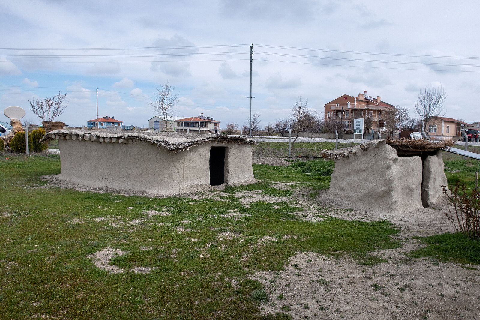
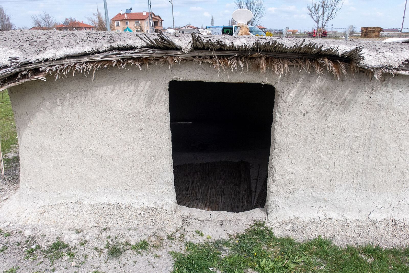
Small oval mudbrick houses formed the settlement’s main architecture. Most covered about 15 to 20 square metres. Their entrances opened at ground level, unlike the entrances at Çatalhöyük, and their floors were repeatedly renewed. Houses were rebuilt in stable locations: one structure in area K was constructed six times on the same spot and according to the same plan.
Houses and interior features
House I in area K measured 5 by 3 metres and had at least two building phases. In its earlier phase, a single row of mudbricks formed the walls, while the floor was replastered five times. The later phase added a second row of mudbricks to reinforce the walls, followed by two more layers of plaster. At least two earlier structures may lie beneath the excavated house.
Postholes within the houses indicate that wooden posts were used at different stages of occupation. Four postholes beside the southern wall of House I belong to this pattern of internal construction. Round hearths occupied the northwestern parts of the houses. Floors in that area were more heavily soiled, while the higher southeastern areas received more carefully finished surfaces.
Some floors were painted wholly or partly red. Phytoliths, microscopic silica bodies formed in plants, show that mats covered parts of the floors, and a cross-woven mat survived on the uppermost plaster floor of House I. Painted reliefs occurred on some northern walls. Red and orange painted areas were also found against a north wall, although their motifs cannot yet be interpreted securely. Machinery damaged parts of the wall reliefs.
Large cattle skulls mounted on walls formed another feature of the settlement’s domestic spaces. Human burials were placed beneath house floors, with the number varying between houses. Early Bronze Age burials were also recovered from the mound, adding evidence for the site’s later use.
Tools, ornaments, and decorated objects
The chipped-stone industry was dominated by microliths, very small stone tools or tool components often used in composite implements. Obsidian, a volcanic glass that can be flaked into sharp edges, was the principal raw material. Projectile points show influence from the Pre-Pottery Neolithic B, while the wider assemblage has similarities to material from the earliest layers of Çatalhöyük and Can Hasan III.
Beads were made from stone and from marine shells, including Nassarius. Bone tools included spatulae, while clay figurines were rare. A decorated stone was found between houses near a refuse heap, and other decorated stones and decorated arrow-shaft smoothers were also recovered. Wall painting and wall relief at Boncuklu Höyük have been described among the earliest known practices of their kind, and the site also produced the earliest known ceramics in Anatolia.
Animals, plants, and wetland surroundings
Wild boar and aurochs dominated the analyzed animal remains, with wild boar most common and aurochs making up approximately 33 percent of the assemblage. Equids, goats, deer, carnivores, birds, and turtles were also represented. Together with the plant remains, these finds reflect a community drawing on a varied landscape of lakes, marshes, and surrounding dry ground.
Plant remains included emmer wheat and barley. Charcoal and plant material associated with wetland fauna provide evidence for reconstructing the vegetation and environmental conditions around the settlement. Elena Asouti’s study of the charcoal contributed to this environmental picture, while Louise Martin’s analysis of animal bones helped clarify the community’s relationship with wild species.