Castro of San Cibrao de Las: A Fortified Gallaecian Settlement in Spain
Site at a Glance
- Rating
- 4.6
- Popularity
- Medium
- Country
- Spain
- Primary era
- Classical
- External website
- Open
- Eras represented
- Classical
- Civilizations
- Roman
- Site type
- City
On this page20 sections
History
Castro of San Cibrao de Las is a fortified settlement in Spain, established during the second century BC by communities of the castro culture, a tradition of fortified towns and villages in the northwest Iberian Peninsula. Occupied continuously from the second century BC to the second century AD, it flourished during the first century AD as Roman rule expanded through Galicia. Its development reflects Romanization, the gradual adoption and adaptation of Roman political, economic, social, and cultural practices by local communities, which produced a society combining Gallaecian and Roman traditions.
Settlement and Romanization
The settlement occupied a defensible elevation with access to cultivable land and control over the surrounding territory. Its position also placed it near the gold-mining area of Laias and other ancient mining zones. The inhabitants combined agriculture, animal husbandry, hunting, mining, textile production, pottery manufacture, and the making of personal ornaments. Cereal cultivation took place on the plains of Las, Loucía, Eiras, A Torre, and Vilar. Oak woodland supplied acorns that were processed into flour, while abundant grinding equipment points to the importance of food processing.
Textile production formed another part of daily life, as shown by numerous loom weights and spindle whorls. Pottery was the most abundant archaeological material. Locally made vessels served for storage and cooking, while imported ceramics show that the settlement participated in wider contemporary trade networks. Large transport vessels carried wine and garum, a fermented fish sauce used in Roman cuisine. Fine tableware arrived from Braga and included terra sigillata, carefully finished Roman tableware that was often stamped or mould-made.
The settlement’s original name remains uncertain. The forms Lambrica, Lanobriga, Lansbrica, and Lansbricae come from different readings of inscriptions, particularly a Roman altar dedicated to Bandua, an indigenous deity worshipped in parts of western Iberia. The site was also traditionally known as A Cidade, meaning “The City.” The altar’s Latin text and Roman lettering, combined with its dedication to a local god, illustrate the coexistence of indigenous religious traditions and Roman cultural forms.
Archaeological investigation and protection
Florentino López Cuevillas and Vicente Risco first examined the hill fort in 1921, and excavation permits were obtained the following year. Between 1922 and 1925, López Cuevillas directed exploratory work in the inner enclosure and the southeastern part of the outer enclosure. These investigations identified the foundations of a square building, confirmed that the inner enclosure was bounded by a single wall, and revealed buildings with elliptical, circular, oval, rectangular, and square plans, together with a cistern or spring installation.
Further campaigns took place between 1948 and 1950 under the direction of Xaquín Lorenzo, with the collaboration and guidance of López Cuevillas. Work exposed the eastern and western gates of the inner enclosure, examined circular and rectangular buildings, and investigated the western sector of the outer enclosure, its second wall, forward ditch, and cistern.
Participants in the Third National Congress of Archaeology recognized the site’s importance and monumentality in 1953. Years of abandonment followed, along with extensive stone removal. Xesús Ferro Couselo intervened when stone was being extracted for road gravel in Carballiño and the surrounding area, helping to stop the destruction.
The construction of a football field beside the hill fort in 1980 led to the discovery of a Paleolithic archaeological site. Clearance and maintenance at San Cibrao de Las then began a gradual recovery of the hill fort itself. Since that time, previously excavated structures have been consolidated, while new investigations have concentrated on the eastern sector of the outer enclosure and have also continued in the west. A project within the Galician Archaeological Heritage Network began in 2001 and included the creation of the Archaeological Park of Castro Culture. Its interpretation center opened on 8 March 2014. The site remains under excavation and study, and excavated objects are housed in the Provincial Archaeological Museum of Ourense.
Remains
Setting and overall layout
The hill fort occupies a small elevation about 473 metres above sea level beside Monte de San Trocado, which rises to approximately 550 metres. It lies at the edge of the plains of Las and Eiras, between the municipalities of Punxín and San Amaro. Monte de San Trocado blocks direct visual contact with the Miño River, while the settlement maintains visual connections with the hill forts of Santa Ádega, Trelle, and Coto do Castro, as well as with the Sierra de San Mamede, Monte Faro, Pena Corneira, and the heights of Vieiro.
The defensive position is naturally strongest on the eastern side, where the slopes are steep. The northern slopes are gentler, and the western and southern approaches are comparatively gradual. Within its walls, the settlement covers approximately 95,900 square metres. About 8,750 square metres belong to the inner enclosure, or acropolis, and approximately 87,150 square metres to the outer enclosure, or anteacropolis. The plan consists of two nearly concentric elliptical enclosures, slightly elongated from northeast to southwest. The east-west axis measures 294 metres, while the major axis measures 420 metres.
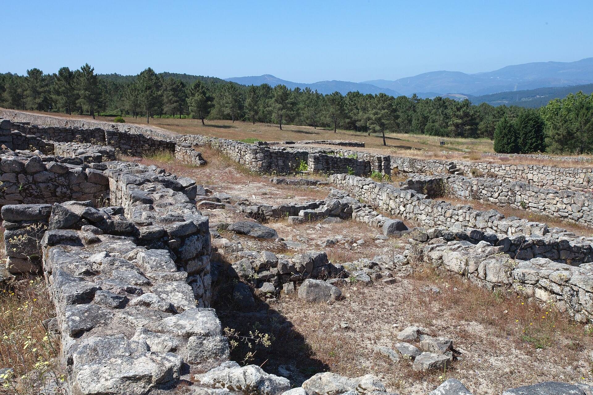
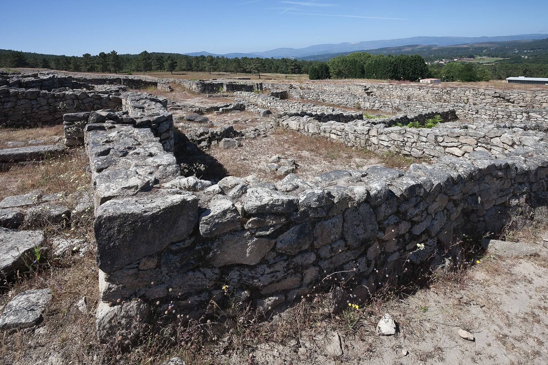
Straight streets produce an almost orthogonal layout, with rectangular buildings predominating over circular ones. This organized arrangement has been interpreted as an evolutionary development associated with Romanization. In the anteacropolis, peripheral streets follow the inner faces of the walls and transverse or radial streets distribute buildings in alignments adapted to the terrain. Some routes were paved with stone slabs.
Inner enclosure
Acropolis walls and gates
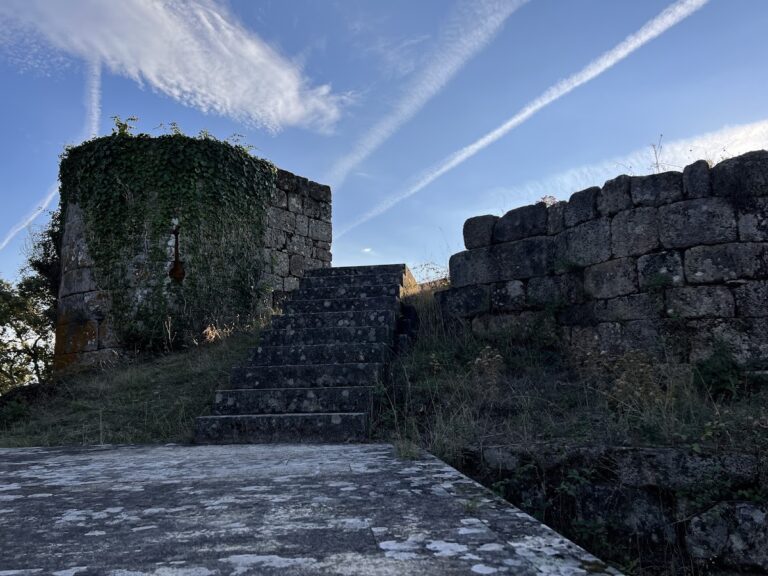
The acropolis is the inner or higher fortified enclosure of the settlement. It is bounded by a granite wall averaging about 3 metres in thickness. A paved walkway may have run along its upper part, reached through lateral passages and stairways built into the wall. These included single- and double-splay stairs. The western and eastern gates were protected by projecting masonry towers or bastions.
Eastern gate
Excavated in 1982, the eastern gate contains two open rectangular guard chambers set within two towers. Continuous benches run along the interiors, and a paved passage with a step-like form leads through the entrance. Access to the acropolis used stairs at the entrances, preventing carts from entering directly.
Western gate
The western gate had two flanking towers, one semicircular and attached to the wall, the other elongated. Its guard chamber was less developed than that of the eastern entrance. When excavated in 1948, the gate stood about 3.5 metres high. The entrance pavement used stones with carved rebates, and the guard chamber contained a fragmentary inscription whose surviving reading is approximately “MI / VLE.”
Buildings and inscriptions
Near an acropolis gate, excavations in 1922 revealed a nearly square granite building with a granite-paved interior. Other structures found by Xaquín Lorenzo had circular or rectangular plans and stood separately from one another. Beside the inner wall, a stone bears a brief dedication to Iuppiter, the principal Roman deity and equivalent of the Greek Zeus.
Outer enclosure
Walls and defensive approaches
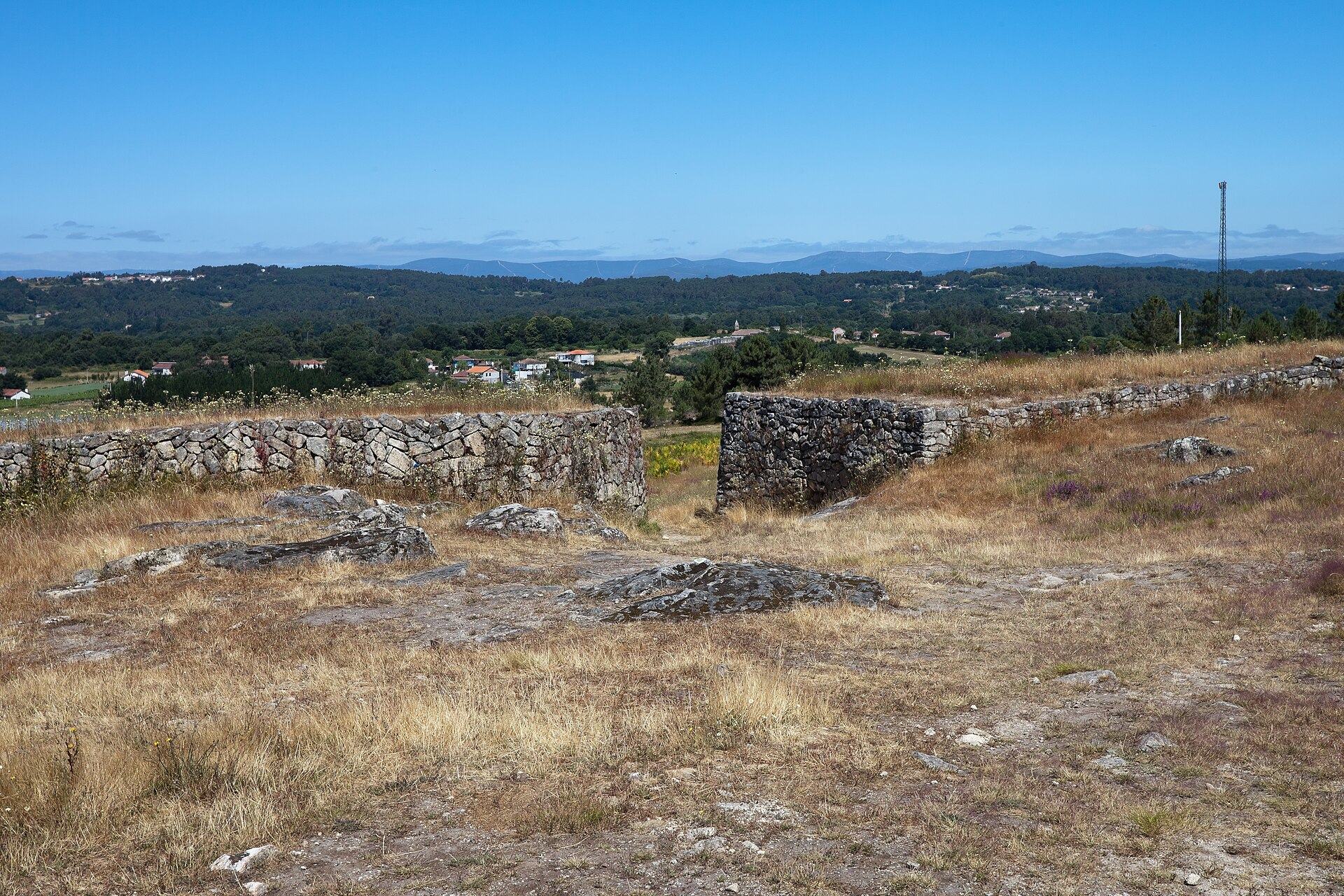
The anteacropolis, the larger outer fortified enclosure, is bounded around most of its circuit by two walls and corresponding ditches cut into soil and granite bedrock. Sections of the defenses were strengthened by an exterior parapet. Western, eastern, and southern gates had flanking towers, some with guard chambers. A third defensive wall began near the western gate, extended 60 metres beyond the southern gate, and joined the second wall.
At the western gate, where the shallow slope made defense more difficult, the wall reaches about 6 metres in thickness and averages 3 metres. It rests on a soil layer no more than 15 centimetres deep, which aided drainage and protected the foundations. Two faces of polygonal granite masonry enclose an interior filling of rubble and earth.
Southern gate
The southern gate rests on granite bedrock and preserves traces of cart ruts and gate joinery. Two projecting towers flank it, and the entrance opens toward a broad ditch between the gate and the second outer wall. The approach forced entrants into this ditch, which may explain why the southern entrance is considered probably the oldest. The ditch continues beyond the gate, possibly as a deceptive defensive feature. A cart road has largely destroyed the southern gate and the nearby walls, leaving the bedrock exposed and the entrance identifiable mainly through archaeological evidence.
Western and eastern sectors
In the western anteacropolis, rectangular and angular buildings predominate, while circular structures form a smaller group. Many buildings were arranged around courtyards, creating courtyard-house groups, and others stood independently. A principal transverse street runs from the western gate toward the central enclosure. The eastern sector remains under systematic excavation by a team from the Provincial Archaeological Museum of Ourense. Its exposed structures display a spatial organization similar to that of the western sector.
Barrio Cuevillas
The southern anteacropolis contains Barrio Cuevillas, named in honour of its discoverer. The group consists of three circular and oval structures enclosed within a rectangular plan with rounded corners. Its shorter side measures 26 metres.
Water installations and central features
Main cistern
The principal cistern or spring lies beside the western gate of the anteacropolis. It has a rectangular plan, with one short side ending in an apse, or semicircular end. It may originally have been covered by a false vault. An underground channel carries a considerable flow of water. The position of the cistern influenced the arrangement of the residential area, which was set back where transverse and peripheral streets met. Beyond the installation, the street approaches the wall while preserving a regular passage about 5 metres wide.
Southeastern spring-cistern
A second spring-cistern was excavated on the southeastern slope in 2008 and 2009. It has an irregular plan and rudimentary stairs, and it lies outside the defensive wall.
Three-stepped structure
Near the eastern entrance to the acropolis stands a square structure formed by three steps. Its shape resembles a traditional wayside cross and may represent a pedestal for a statue. A small hoard of bronze coins from the mid-fourth century AD was found beneath one of the steps.
Objects and religious evidence
The excavations have produced bronze personal ornaments, including pins, hair fasteners, pendants, brooches, and buckles. Omega-type buckles predominate. One of two antenna daggers found at the site, a type whose hilt ends in projecting antenna-like elements, was recovered with associated pottery that included terra sigillata and roof tiles.
Bronze coins dating from the early first century AD came from mints in the middle Ebro valley or Mérida. The later coin hoard beneath the three-stepped structure adds evidence for activity in the fourth century AD. Loom weights and spindle whorls reflect textile production, while numerous grinding implements relate to the processing of food and acorns.
Local pottery includes large storage jars and smaller vessels for use on the hearth. Imported pottery includes large transport containers, Bracarense ceramics associated with the Braga region, and terra sigillata. Near the western gate of the central enclosure, two inscriptions found during the 2003 campaign include one reading “SADU / ULAD / V” and a stone marker inscribed on both faces with unclear characters. The altar dedicated by Aemilius Reburrinus to Bandua is associated with the settlement’s territorial sphere, although its exact findspot is uncertain. It has long been kept in a private house in the nearby parish of Eiras.