Castra Gerulata: A Roman Auxiliary Fort on the Danube Frontier
Site at a Glance
- Popularity
- Medium
- Country
- Slovakia
- Primary era
- Classical
- Eras represented
- Classical
- Civilizations
- Roman
- Site type
- Military
- Remains
- Fort
On this page25 sections
History
Roman foundation and frontier role
Castra Gerulata was a Roman auxiliary fort at Rusovce, now part of Bratislava, Slovakia, probably established under Emperor Domitian in the late first century AD. An auxiliary fort housed units serving alongside the Roman legions. Gerulata formed part of the Danube frontier, a zone of military installations and surveillance, and may have been Rome’s first auxiliary fort east of Carnuntum.
The wider Bratislava region had a Celtic fortified settlement during the La Tène period, an Iron Age culture associated with Celtic peoples across much of central Europe. Roman military occupation along the Danube began in the first century AD. Gerulata’s foundation is linked tentatively to the Dacian crisis of AD 85-89, Rome’s conflict with Dacia. The fort watched a narrow corridor between the wooded Little Carpathians and the Great Rye Island, where the landscape narrowed towards the Danube. It probably helped protect a river crossing, the mouth of the Morava, and roads connecting Carnuntum with other frontier forts. The area also lay at a meeting point for long-distance routes, including the Amber Road, so military activity served economic interests as well as frontier defence.
The earliest fort was built of timber and earth. Its construction has been associated with a detachment of either Legio XIV Gemina or Legio XV Apollinaris, and possibly Cohors V Callaecorum Lucensium. The later garrison included Ala I Cannanefatium, transferred from Lopodunum in Germania, as well as Cohors XVIII Voluntariorum Civium Romanorum and Cohors Aelia Sagittariorum. Soldiers from Legio X Gemina and Legio XIV Gemina are linked to rebuilding work. Equites Sagittarii, mounted archers, are associated with the fort in the late Roman period.
Ancient records preserve several forms of the place name. It appears as Gerulata in the Itinerarium Antonini, as Gerulatis in the Tabula Peutingeriana, and as Gerolate in the Notitia Dignitatum.
Stone rebuilding and late Roman transformation
The timber-and-earth fort was replaced by a stone installation in the second century, probably during the reign of Antoninus Pius (AD 138-161). The new fort may have undergone a further rebuilding. It was likely damaged or destroyed during the Marcomannic Wars, second-century conflicts between Rome and the Marcomanni and their allies. The extent of the destruction is uncertain, but the fort was rebuilt in the late second or early third century.
From the late third or early fourth century, during or after military reforms associated with emperors Diocletian and Constantine, Gerulata was reduced and altered into a late Roman stronghold. Under Valentinian I, probably during frontier campaigns in AD 374-375, the remaining garrison withdrew into a small fortified enclosure. The larger walled area appears to have passed into civilian use and developed as an oppidum, or fortified settlement.
Civilian life and abandonment
A civilian settlement, or vicus, grew around the fort. Traders and craftspeople supplied the soldiers, and workshops operated among other buildings. Gerulata may also have served as a regional trading centre during its first two centuries. The surrounding area included a separate settlement and a villa estate, reflecting a wider pattern of civilian occupation beyond the fort.
The fort was probably abandoned during the first third of the fifth century. By about AD 433, when Pannonia was ceded to the Huns, its Roman inhabitants had left.
Investigation and protection
English travellers Richard Pococke and Jeremiah Milles described Roman ruins at Rusovce in 1737, and Mátyás Bél wrote about the remains in 1777. Ágoston Sőtér’s excavations in 1889-1891 uncovered the late Roman stronghold and graves. Further investigations followed in 1932-1933 and the early 1940s. In 1947, Vojtěch Ondrouch prepared a plan of the Roman settlement using finds recovered during agricultural and building work; excavations in 1949 uncovered a child’s grave with burial goods.
Earthworks in the 1960s exposed parts of a late Roman building and led to renewed archaeological work. Excavations continued between 1965 and 1972, followed by further campaigns in 1976. After building restrictions in Rusovce were lifted in 1990, construction and infrastructure projects prompted rescue excavations by several institutions. Later investigations, including work in the museum area in 2006-2007, added evidence about the fort and its civilian settlement and prompted a reassessment of their development. Inscriptions found during conservation of the late Roman stronghold’s walls attest to a nearby temple of Jupiter Dolichenus, a Roman military-cult deity associated with Doliche in Syria. The fort, civilian settlement, and cemeteries are protected under Slovak heritage law and have formed part of the UNESCO-listed Danube Limes of the Roman Empire since 2021.
Remains
The remains occupy a gently raised, roughly rectangular alluvial terrace about 130-136 metres above sea level. The sequence of military buildings runs from a timber-and-earth fort to a stone fort and a compact late Roman stronghold, while the civilian settlement and burial areas spread around them. The terrace lies beside a former branch of the Danube; the river’s present main channel is about 1.3 kilometres away.
The earliest fort
Timber-and-earth defences
The earliest fort stood on the western bank of the Rusovce channel, on ground that drops more than three metres towards the former riverbed. The Danube eroded parts of its northern and eastern sides. Two V-shaped ditches formed its outer defences, set about five metres apart and measuring 1.3 and 1.8 metres deep. Excavation traced 27 metres of the southwestern ditch, while the fort’s maximum width is estimated at about 113 metres. Italian and Gallic terra sigillata, fine red-slip Roman tableware, and a Loeschcke IXc lamp from the ditches support a date under Domitian. The ditches were probably filled during Antoninus Pius’s reign.
Timber-framed barracks
A barracks dated to the Domitianic or Trajanic period was partly excavated. Its walls used upright timbers with woven rods between them, covered with clay infill, mortar plaster, and limewash. The plan included four rooms in two parallel rows and two small ovens, aligned with the Rusovce channel. Fire destroyed the building. Its internal plastering suggests that it may have been one structure divided by a central corridor, although it could instead have comprised two buildings placed back to back.
Room 1 measured about 3.10-3.12 metres across and 2.20-2.70 metres long. It retained a packed-earth floor and grey lime-and-sand plaster, which survived in places to 10 centimetres high and reached 40 centimetres at the northeast corner. A passage between Rooms 1 and 2 was 0.60-0.80 metres wide and had rubble-stone thresholds. Room 2 measured about 3.02-3.10 by 3.60 metres. Its gravel floor was covered with lime mortar containing crushed brick, and impressions in the south wall preserve the positions of square timber supports with interwoven rods.
An oval oven beside Room 2 measured about 62 by 52 centimetres and was 20 centimetres deep. Its clay walls contained limestone, quartz, resin, and mica. The oven was rebuilt at least once, with parts of the earlier structure reused in the later base; brick tiles and fragments of the earlier oven paved the area in front of its opening. A second oven, about 52 by 35 centimetres, stood in Room 3 beside the partition with Room 2. Room 3 had a packed-earth floor, and only the northwest corner of Room 4 was exposed.
The second-century stone fort
Enclosure and internal buildings
The stone fort was built after the early ditches had been filled, probably under Antoninus Pius. Its estimated width was 133-166 metres. A section of the southern defensive wall, about one metre thick, was uncovered beside the Rusovce channel, with an earthen rampart running along its inner side. A double ditch associated with this fort was found in the northwest near St. Magdalena’s Church.
At Irkutsk Square, excavators found stone buildings and a 10-20-centimetre layer of broken bricks, apparently levelled during a later building phase. A wall 40-60 centimetres wide, probably part of the fort’s interior, was also observed in the area later occupied by the stronghold.
Ditches beyond the fort
Two further ditches found in Ulica Pohranicnikov ran northeast to southwest, about 300 metres from the earlier fort beside the channel. Each was 6-7 metres wide and 2.5 metres deep, and they lay 4.5-5 metres apart. A coin of Marcus Aurelius suggests they were levelled after the Marcomannic Wars. Their purpose remains uncertain: they may have defended the western civilian settlement or belonged to another military installation.
The late Roman stronghold
Reduced defences
The late Roman fort was smaller than its predecessors and substantially altered. A coin of Aurelian, found in collapsed masonry, gives only a broad indication of when rebuilding may have begun. Defensive remains were found beneath the parish granary south of the museum area. Horseshoe-shaped and fan-shaped towers have been proposed for this phase, but their presence is uncertain.
The square fortified building
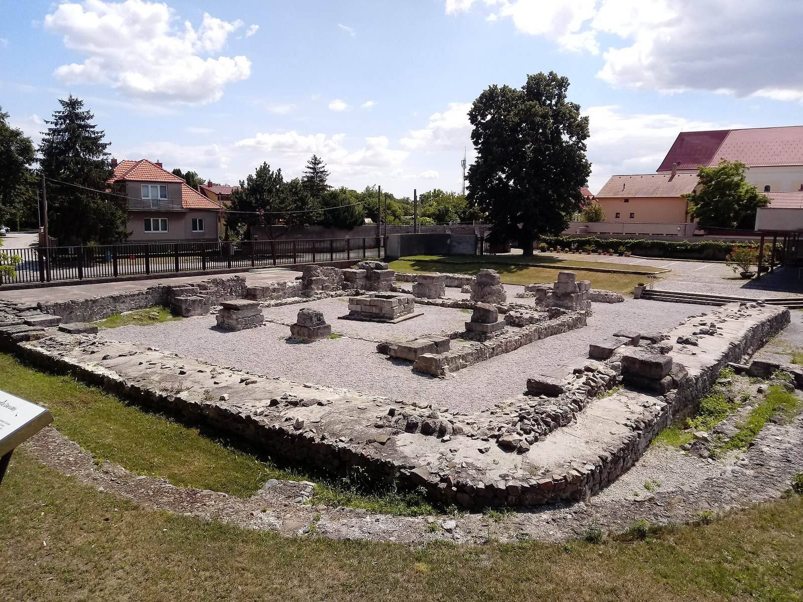
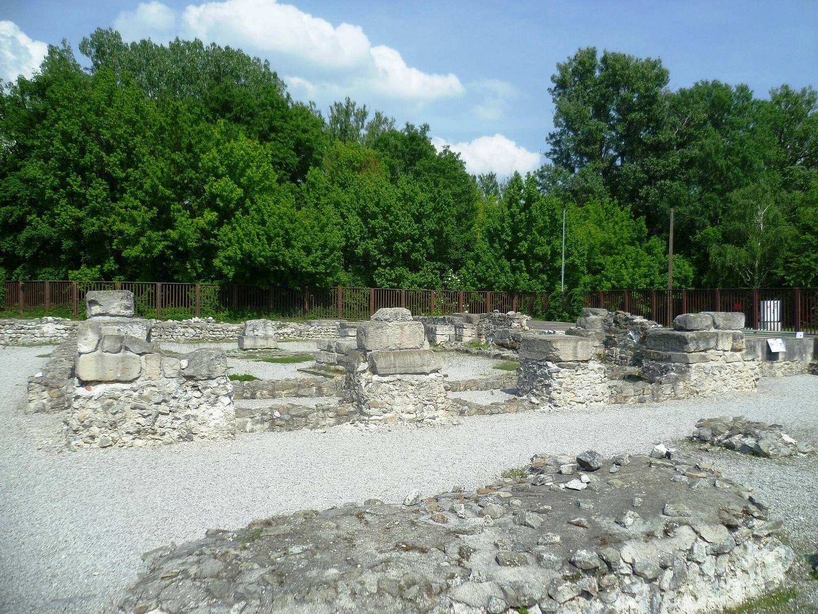
The best-preserved fortification is a square burgus, a compact late Roman stronghold, measuring about 30 by 29 metres. Twelve piers surrounded an open courtyard about 12 by 12.4 metres across and supported the roof. Their foundations extended three to four metres into the ground, while the walls, built using cast masonry, reached 2.4 metres thick. The construction suggests a building that may have risen to three storeys. The ground floor opened onto the courtyard, and the upper floors were probably occupied. A stone-lined well about eight metres deep stood in the courtyard.
The building’s construction varied across its plan: the south and west perimeter walls do not bond with the adjoining walls at the corners. The burgus has been compared with post-Valentinian fortifications in Noricum and Pannonia and may have stood in the fort’s front-left corner. Tombstones, votive altars, and carved reliefs were reused in its piers and walls, including the lining of the well. Some of these pieces are displayed in the museum lapidarium. In the south wing, builders later blocked openings between the piers to create a grain store, the last Roman building work identified at Rusovce. Conserved foundations are presented in the outdoor exhibition area.
Civilian settlement and surrounding occupation
The settlement around the fort
The civilian settlement extended mainly northwest and southwest of the fort, with built-up areas also surrounding it on three sides. Its western sector occupied a low rise, while the eastern part lay in a shallow hollow. A branch of the Danube bounded its northern and western sides. Early buildings included simple sunken huts and mud-brick structures. Flavian-period remains were found in Pohranicnikov Street, and rescue excavations in 1998 showed that the settlement extended to Balkanska Street.
The largest area lay beyond the fort’s western gate, where workshops and several layers of occupation were excavated. Some of the settlement’s most prominent buildings stood north of the fort along the road. Stone foundations there included a building with underfloor heating, or a hypocaust. It underwent at least one rebuilding before its destruction; simple wooden huts were then built on the site in the late fourth century. Lime and brick kilns were found near Cemetery II.
Nearby settlements and villa estate
A separate Roman settlement lay about 2.5 kilometres southwest of the fort. A villa estate about three kilometres south comprised as many as six buildings and dates to the Severan period, the era of a Roman imperial dynasty in the later second and early third centuries. Finds in the surrounding area include sunken timber-framed dwellings with pitched roofs. The area appears to have remained largely inhabited by an indigenous population with substantial Celtic influence in the second century. In the third century, rectangular ditches divided part of the settlement into plots, and two buildings with stone foundations were added.
Cemeteries and burials
Five cemetery areas formed an arc northwest and west of the settled area, and more than 300 graves have been excavated. Their burial practices changed over time: cremation was used in early periods, while inhumation became more common in Late Antiquity, the later centuries of Roman history. Graves include simple pits and brick-tile constructions; gravestones and fragments of larger monuments point to more elaborate markers, and one sarcophagus was found.
Cemetery Ia/Ib
Cemetery Ia/Ib, at the school, dates from the second to fourth centuries and contains both cremation and inhumation burials.
Cemetery II
Cemetery II, at the village cemetery, dates to the first and second centuries and served people associated with the timber-and-earth fort and its canabae, a settlement connected with a legionary camp. It contains the earliest graves identified at Gerulata. Cremations included burials in pits and at designated burning places.
Cemeteries III, IV, and V
Cemetery III, near St. Vitus Church, dates to the fourth century and may have formed part of Cemetery II; it may also have followed the main frontier road. Cemetery IV was likewise near St. Vitus Church, while Cemetery V was near the railway station. Cemeteries I and V began in the Trajanic period. A skeleton grave northwest of the fort probably lay near the boundary of the oldest civilian settlement area.
Objects and carved remains
Trade goods and everyday objects
Finds from Gerulata include coins of Galba, Vespasian, Titus, and Domitian, as well as imported objects that point to connections with southern parts of the empire. These include bronze vessels, amber amulets, a gold amulet showing Victoria, the Roman personification of victory, an iron vessel with a bronze foot, a mirror frame depicting the Dioscuri, the twins Castor and Pollux, a faceted beaker, clothing brooches, lamps, and an oil amphora marked with an inscription and measuring marks. Tableware from the Domitianic period came from workshops in La Graufesenque, central and eastern Gaul, Rheinzabern, and Raetia.
A marble cornucopia fragment made in northern Italy probably belonged to an over-life-size statue of Fortuna, the goddess of fortune. Other finds include a burial with bronze and iron knee brooches, tweezers, and shoe nails, found among brick waste that may have come from a privately operated brickworks associated with the fort’s first building phase. Horse skeletons, a lime kiln, and a glass furnace were also found south of the fort or nearby.
Military equipment and reliefs
Military finds include a decorated parade helmet dated to the first or second century, spearheads, ring daggers, belt fittings, amulets, and the head of a silver-plated statuette. Among the carved reliefs reused in the stronghold is one showing a horseman with a spear and smithing tools; another depicts an eagle and a rosette between two cornucopias. A painted relief of Daedalus and Icarus retains traces of its original colour, while a fragment from a grave monument shows a figure with two griffins.