Caisses de Jean-Jean Oppidum: A Fortified Gallic Settlement in France


Site at a Glance
- Rating
- 4.7
- Popularity
- Low
- Country
- France
- Primary era
- Classical
- External website
- Open
- Eras represented
- Iron Age, Classical
- Civilizations
- Celtic, Roman
- Site type
- Military
- Remains
- Fortified Town
On this page22 sections
History
Caisses de Jean-Jean Oppidum is a fortified Gallic archaeological site in Mouriès, France, occupied from the Iron Age around 700 BC until the end of the 3rd century AD. Built within a naturally protected limestone basin, it developed through successive phases of fortification and settlement before its population gradually moved toward the plain and the Jean-Jean foothills.
Iron Age Origins
The basin is oriented from east to west. Steep limestone cliffs protected its northern and southern sides, while their eastern convergence formed an acropolis, the elevated and especially defensible part of an ancient settlement. The western approach was more open and led toward an esplanade about 300 metres long, making this side the focus of the settlement’s defenses.
Occupation began in the Early Iron Age, and a sanctuary probably existed here during the 7th or 6th century BC. Its later abandonment is indicated by limestone votive stelae reused in the principal rampart between the 4th and 3rd centuries BC. These objects preserve evidence of an earlier sacred phase within the history of the settlement.
Fortifications were established from the 6th century BC and repeatedly enlarged or altered through the 1st century BC. The first western rampart predates 500 BC, while its final rebuilding, represented by the remains visible today, took place between 180 and 150 BC. Archaeological evidence points to particularly intensive habitation between the 5th and 2nd centuries BC, although occupation continued across a longer period.
Expansion and Rebuilding
The western entrance and its defenses were developed during the 6th century BC. Four ditches, earth embankments, and a line of projecting stones known as a chevaux de frise were eventually added to obstruct attackers, animals, and wheeled vehicles. The two ditches nearest the principal rampart belong to the period between the 6th and 4th centuries BC. The outer two ditches and the stone obstacles were added at the end of the 2nd century BC.
A violent fire around 100 BC destroyed the entrance and the settlement’s buildings. The entrance was rebuilt with a curved defensive arrangement called a clavicula, which forced approaching traffic to turn. Buildings in the settlement were reconstructed during the first part of the second half of the 1st century BC, but this renewed occupation was brief. The upper part of the oppidum was abandoned around the transition from the 1st century BC to the 1st century AD.
Roman presence from the middle of the 1st century BC ended the principal rampart’s defensive role. As the Romanization of Provence accelerated under Augustus, the first Roman emperor, the rampart was abandoned and gradually deteriorated. The southern slope and the spur remained inhabited until the end of the 3rd century AD. A former collective building was eventually used for agricultural purposes as inhabitants moved toward the foothills, before the site was finally abandoned.
Roman-Period Settlement and Interpretation
The southern foothills had been occupied since the Early Iron Age. Surface finds and a limited sounding indicate a rural settlement of some importance during the Gallo-Roman period, probably a vicus, a small Roman settlement or locality. The area has not been systematically excavated, but pottery, coins, roof materials, and other remains indicate that settlement continued beyond the decline of the upper oppidum.
The relationship between the oppidum and Tericiae, a place-name preserved in the Peutinger Table, remains uncertain. One interpretation places Tericiae in the plain below, where people may have moved after the establishment of Roman peace. Another treats the oppidum and Tericiae as contemporary settlements with peripheral quarters rather than as one site.
Archaeological Investigation
Fernand Benoit excavated the oppidum during the 1930s and early 1940s. His work found no residential walls between the two principal ramparts, but indigenous pottery from the area reinforced the evidence for intensive occupation between the 5th and 2nd centuries BC. Soundings at the basin took place in 1962, further stelae were found at the foot of the rampart in 1965 and in 1985–1986, and the Zone 01 habitation was excavated between 1978 and 1982.
The site was listed as a historic monument in 1937 and is protected under France’s Heritage Code. Its archaeological remains and movable finds are therefore subject to legal protection, including prohibitions on unauthorized collection, digging, and metal-detector use.
Remains
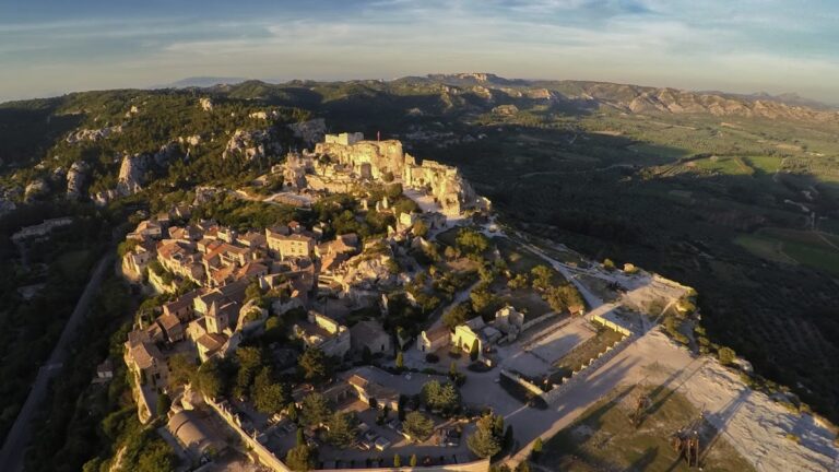
The surviving site occupies a limestone basin enclosed by cliffs and organized around a heavily defended western approach, an eastern acropolis, slopes, and residential areas. The principal rampart appears as a broad mound of stone and earth between the cliffs, while ditches, embankments, gates, dwellings, ritual objects, and water-management features preserve parts of the settlement’s changing layout.
Western Fortifications
Advanced Rampart
The first rampart lies about 300 metres west of the principal rampart and crosses the basin between two rocky ridges. It is approximately 4 metres wide, with lateral faces retaining a rubble core. The modern track passes through the position of its former gate. The area behind this advanced wall may have served to corral livestock or to shelter people living outside the fortified settlement.
Principal Rampart and Tower
The principal rampart consists of successive walls placed in front of one another between the 6th and 1st centuries BC. This construction created a defensive mass more than 10 metres thick. A semicircular central tower projects from it, measuring about 10 metres across at its widest point. The tower probably belongs to the later defensive phase associated with the two westernmost ditches and their embankments. Its scale combined a defensive function with the display of the settlement’s status.
Ditches and Stone Obstacles
Four dry ditches extended across the western defenses, separated by earth embankments, or aggers. Irregular blocks were placed in a staggered line beyond them as a chevaux de frise, an obstacle intended to hinder war machines and infantry charges. Ditch S1 is about 5 metres wide and 1.10 metres deep. Ditch S2 was cut into the limestone, reaching approximately 6 metres in width and 1.90 metres in depth, with rock-cut sides that made crossing difficult.
Ditch S3 is narrower, about 1.50 metres wide at its opening, with near-vertical sides and a flat bottom roughly 0.80 metres wide. It cuts about 1 metre into the rock and is reinforced by the A2 embankment and wall MR1. Ditch S4 is also rock-cut, approximately 3 metres wide and up to 1.50 metres deep. Its near-vertical sides and flat base create a U-shaped profile, while its fill contains earth, stones, and blocks that fell from wall MR1.
Additional Ramparts and Entrance
Peripheral Defenses
Other ramparts enclosed parts of the basin and slopes. The eastern rampart followed the incline from the northern cliff toward the southern cliff and remains visible for about 50 metres before disappearing where it was destroyed. It overlies a 2nd-century BC habitation that included walls beside a large refuse pit and a hut floor cut into the rock.
On the southern slope, a western rampart occupied the narrowest ground. A vertical cliff protected its northern side, while a rocky projection to the south stood above a new cliff between 8 and 10 metres high. A stepped natural limestone ridge connected these defenses. Only fragmentary traces survive from a fortification once placed on the summit of the southern cliff, and another rampart is known from surface evidence.
Western Gate
The western gate was the settlement’s sole entrance and stood against the southern cliff. The present path follows the ancient approach, and a guard room occupied the space between the gate and the cliff. After the fire around 100 BC, the rebuilt entrance included a bent, bayonet-shaped clavicula. Deep wheel ruts around the turn were formed by carts using the entrance.
Beyond the gate, the route turned north at a right angle along an ancient street between residential blocks. A natural stairway-like passage on the western side led toward the Servanes plain and its permanent spring. Routes also connected the oppidum with contemporary settlements in the Alpilles, including the Castellas of Maussane and Aureille.
Residential Areas
Zone 01
Zone 01 preserves a 5th-century BC dwelling that was abandoned during the 4th and 3rd centuries BC. During a large-scale reoccupation in the 2nd century BC, it was replaced by a four-room building arranged on either side of a pedestrian lane. Room 1 probably served as storage, since it contained urns, large storage jars, and amphorae, as well as an earlier pit used for extracting clay. Room 2 had a hearth and probably functioned as a living room, while the purposes of Rooms 3 and 4 remain uncertain because excavation was incomplete.
After the fire around 100 BC, the building was reconstructed during the first part of the second half of the 1st century BC. A deflecting wall and pavement protected Room 1 from rainwater. Room 4 incorporated a reused monumental doorway threshold in the Hellenistic tradition, probably taken from an earlier public or private building that had been destroyed.
Zone 06 and the Eastern Plateau
An Augustan-period house occupied the end of a residential block in Zone 06, between a wall parallel to the later rampart and a street to the east. Its foundations cut into an earlier rampart, its destruction mound, and a large ash mound. The house contained several rooms, reflecting Roman architectural influence in contrast with the predominantly single-room Gallic dwellings.
The house replaced a short-lived 5th-century BC habitation of three modest rooms, each about 10 square metres. For more than a century, the occupants accumulated an ash mound over 10 metres in diameter and up to 1.30 metres thick. Its purpose is uncertain. It may have been connected with ritual activity, communal feasting, a hearth dump, or craft work. Pottery fragments and kitchen waste were found within it.
By the middle of the 1st century BC, a row of houses had been built against the rampart. Their walls were made entirely of stone, sometimes covered with plaster, and some roofs used tiles. This group was gradually abandoned during the final years of the 1st century BC after an occupation of about forty years.
Four houses on the eastern plateau retain walls approximately 1.50 to 2 metres high. Their substructures may date from the 5th or 4th centuries BC, while the visible houses are generally assigned to the 1st century BC. They were built with adobe, or sun-dried mud brick, without dressed-joint masonry, and reused limestone roofing slabs with drip edges. A Greek graffiti inscription, small bronze bull figurines, and a coin from Massalia, the ancient Greek colony at modern Marseille, attest to activity or rebuilding in this residential area.
Collective Building and Water Management
Collective Building
Beneath the southern cliff, a collective building about 12 metres long and more than 4 metres wide was constructed around the second half of the 2nd century BC. An eastern canopy with a hearth sheltered the entrance, while a bench ran along three interior walls. Yellow clay covered the walls and floor, and only a few broken vessels remained on the floor.
The building burned around 100 BC and was rebuilt a few years later on the same plan, shifted northward, possibly because rainwater flowed down from the cliff. The reconstruction used stonework bonded with earth and incorporated many blocks from the roof of a destroyed Hellenistic monument.
Runoff Reservoir
Several substantial walls surround a hollow at the lowest point of the oppidum, where rainwater converges. The hollow may have functioned as a reservoir for runoff. A channel may have carried overflow toward a collector beneath the gate’s guard room, linking water management with the fortified entrance.
Ritual and Foothill Finds
Votive Stelae
Iron Age limestone votive stelae were reused in the principal rampart. About 1.80 metres high, they have four decorated faces and rounded tops. Their carvings include horses, mounted figures, birds, pectiform signs, and sometimes a radiant-headed figure. The riders appear as heroic horsemen carrying javelins. The stelae are now preserved at the Musée départemental Arles antique.
Southern Foothills
Material from the southern foothills includes pottery sherds, coins, a fired-clay firedog, roof tiles, and sawn limestone roofing slabs with drip edges. A limited sounding exposed a habitation floor containing charcoal, daub fragments, and handmade pottery. A fibula fragment dates this floor to the 6th or 5th century BC.
A paved area made from reused sawn limestone roofing slabs was exposed by clandestine excavation. Surface walls and abundant Late Iron Age and early Imperial pottery indicate a substantial rural settlement in the foothills during the Gallo-Roman period. The area also preserves evidence for later agricultural use as settlement shifted away from the upper fortified site.