Burg Gleichen: A Medieval Hilltop Castle Ruin in Germany


Site at a Glance
- Rating
- 4.6
- Popularity
- Medium
- Country
- Germany
- Primary era
- Medieval
- External website
- Open
- Eras represented
- Medieval, Early Modern, Modern
- Civilizations
- Holy Roman Empire
- Site type
- Military
- Remains
- Castle
On this page23 sections
History
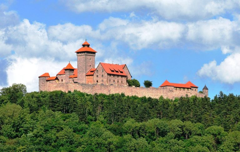
Burg Gleichen is a medieval hilltop castle ruin in Germany, near Wandersleben in Thuringia. The castle is generally dated to the eleventh century or the period around 1000 to 1100, and it formed part of the Drei Gleichen group of castles. Its position above routes through central Thuringia gave it a military and administrative role that changed repeatedly during the Middle Ages and early modern period.
Early fortification and the eleventh century
Fortified activity on the hill began as early as the beginning of the eighth century. The installation was probably connected with the Frankish conquest, although no built remains from that phase survive. The medieval castle was first mentioned in 1034, when the annals of Reinhardsbrunn Abbey called it “Gliche.” The name probably comes from the Celtic word glich, meaning “rock.”
Burg Gleichen entered the history of the Saxon revolt against Emperor Henry IV in 1088. Margrave Ekbert II of Meissen, a leading member of the Saxon aristocratic opposition, sought refuge in the castle. An imperial army began its siege on 14 August. On Christmas Eve, a surprise sortie broke through the besieging force. Archbishop Siegwin of Cologne and Bishops Burkhard of Lausanne and Otto of Regensburg, who were present with contingents in the imperial camp, were killed or captured. The early fortification was later destroyed, and the surviving castle does not preserve remains from that first medieval installation.
Mainz, the Counts of Tonna, and renewed conflict
Around the turn of the twelfth century, Burg Gleichen came into the possession of Henry II of Laach, the first known Count Palatine of the Rhine. This was a high-ranking imperial office associated with major political standing and territorial authority. Through his marriage to Adelaide of Weimar-Orlamünde, the daughter of a Thuringian count, Henry was related to the Ascanian family. He used the castle as a staging post and as an administrative center for his possessions in Thuringia and Saxony.
Between 1134 and 1137, Henry’s grandson, Count Palatine William, and William’s mother transferred the castle to the Archbishopric of Mainz. Mainz was both an important ecclesiastical territory and a political principality of the Holy Roman Empire. In 1162, its archbishop granted Burg Gleichen as a fief to the Counts of Tonna. A branch of that family later took the title Counts of Tonna and Gleichen, which was eventually shortened to Counts of Gleichen. The identity of the family member responsible for the initial transfer to Mainz remains uncertain in the surviving tradition, which attributes it either to Count Ernst I or to his brother, Count Lambrecht I.
The castle strengthened Mainz’s position against the rising Thuringian dynasties of the Ludowingers, Schwarzburgs, and Kevernburgs. The Counts of Tonna were Mainz’s allies and acted as protectors of Erfurt, the city’s Peterskloster, and other possessions in central Thuringia. In 1170, Count Ernst II of Gleichen-Gleichenstein, a member of a family branch representing Mainz in the Eichsfeld, was captured while defending Harburg and executed with imperial approval. Conflict with the Thuringian landgraves followed, and Burg Gleichen was besieged and destroyed again in 1178.
Expansion, fire, and declining influence
Relations between the landgraves and the Counts of Gleichen later improved. The family expanded its possessions through grants, offices, inheritances, and purchases. Its holdings included Emleben, Günthersleben, Wechmar, Schwabhausen, Gräfenhain, Ohrdruf, Sülzenbrücken, Wandersleben, estates in the old town of Erfurt, and the Steinsee below Burg Gleichen. Members of the family also took part in crusades, and around 1200 some held influential positions at the Danish royal court.
Financial pressure eventually led to the sale or pledging of possessions. Gräfenhain was sold to Georgenthal Abbey in 1230. On 31 May 1231, lightning caused a major fire at Burg Gleichen. Repairs followed during a period of growing tension with Erfurt, but the family’s influence in the city declined. Its bailiwick rights were pledged to Erfurt in 1283, and its authority over the Peterskloster ended in 1373.
The family recovered some of its position through territorial transfers and inheritances. Landgrave Balthasar granted the Counts of Gleichen territory centered on Ohrdruf in 1385, and further acquisitions followed in 1409 and 1416. The family divided its possessions among three lines, Gleichen-Blankenhain, Tonna, and the line that retained the core county around Burg Gleichen. The male line of the Counts of Gleichen became extinct in 1631.
Renaissance residence and abandonment
The Peasants’ War and the Reformation affected the county during the sixteenth century. As the family developed other residences, including Schloss Ehrenstein at Ohrdruf, Burg Gleichen ceased to serve as its principal residence. It continued to function as an administrative center and prison, but began to decay. In 1588, Count Philipp Ernst of Gleichen built a Renaissance residence in the western part of the castle. The official residence moved to Ohrdruf in 1590, and Philipp Ernst abandoned the mountain castle in 1599.
After the Counts of Gleichen died out, the Archbishopric of Mainz became the owner again. By 1639 the castle was uninhabited and had been plundered. The Counts of Hatzfeld then received the lordship of Gleichen, including the castle and Wandersleben, as a fief and adopted the title Counts of Gleichen and Hatzfeld. They remained in their hereditary lands and appointed only an administrator in Thuringia, so the ruin continued to deteriorate. The Hatzfeld line ended in 1793, and the fief returned to Mainz.
Ownership and preservation
Burg Gleichen remained under the Archbishopric of Mainz until 1803, when the Reichsdeputationshauptschluss transferred it to Prussia. French rule followed in 1806, and the ruin was threatened with demolition for building materials. Professor Placidus Muth of the University of Erfurt appealed to Napoleon, the French military ruler and emperor, after which the castle was donated to the university. It returned to Prussian state ownership in 1816, following the dissolution of the University of Erfurt on 12 November that year.
Prussian General Baron Karl von Müffling purchased the ruin for 800 thalers in 1817 and ordered repairs to some stairways. In 1841, the remaining roof of the Renaissance building was removed because cracks had raised concerns about the stability of its supporting walls. Without the roof, rainwater entered the masonry and accelerated the ruin’s decay.
Initial repair work began in the winter of 1897 at the initiative of the Erfurt section of the Thuringian Forest Association. Donations supported emergency stabilization and the construction of a new cistern before the First World War. Repeated vandalism led the Duke of Saxe-Coburg and Gotha to secure the ruin with barbed wire and prohibit entry. In 1934, after negotiations involving the Erfurt section of the German Heritage Protection Association, the city of Erfurt received the ruin as a gift and granted the association a 90-year heritable building right. Visitors were readmitted on 31 October 1934 after decades of inaccessibility.
After the Second World War, and officially from 1960, the Working Group for the Care and Preservation of Burg Gleichen managed the ruin as an open-air museum. The keep was adapted as an observation tower and housed a collection on the castle’s history. The Erfurt city museums assumed management in 1984, and the Stiftung Thüringer Schlösser und Gärten took over in 1998. The wider Drei Gleichen landscape has been protected since 3 February 1960 and was later supplemented by additional nature reserves.
The Count of Gleichen legend
Burg Gleichen is associated with the legend of Count Ernst of Gleichen. According to the story, he joined the Fifth Crusade in 1227, was captured, and escaped with the help of the Sultan’s daughter Melechsala, whom he promised to marry. The tradition says that she was baptized Angelika and that the pope allowed Ernst to enter a second marriage.
The legend probably drew on the tomb slab of Lambert II of Gleichen in Erfurt Cathedral. The slab depicts Lambert with his first wife, Ottilia, and the woman he married after Ottilia’s death. From the fifteenth century onward, the Counts of Gleichen used the double-marriage story to enhance their social prestige. They commissioned a richly illustrated tapestry, and around 1800 visitors were shown an unusually wide bed in the castle’s “Junker’s Chamber” as the supposed shared bed of the three spouses.
Veit Winsheim, a pupil of Philipp Melanchthon, later reshaped the story to support Landgrave Philip I of Hesse’s attempt to justify a second marriage. The tradition continued to influence literature and music, including Johann Karl August Musäus’s Melechsala of 1786 and Franz Schubert’s unfinished opera Der Graf von Gleichen, composed in 1827 and 1828 with a libretto by Eduard von Bauernfeld.
Remains
Burg Gleichen occupies a conical summit at 369.6 metres above sea level, about 100 metres above the landscape shaped by the Gera and Apfelstädt rivers. Its polygonal plan follows the summit plateau. The hill belongs with the nearby Kaffberg, Röhnberg, and Kallenberg to the Eichenberg-Gotha-Saalfeld fault zone. Its geological layers consist mainly of Steinmergelkeuper of the Arnstadt Formation, capped by Buntsandstein. Travertine at the foot of the hill provided easily quarried building material.
The southern slope has exposed Keuper layers, dry sunlit conditions, xerophytic vegetation, and rare steppe-heath plants. The summit has no natural springs, making cisterns and stored water essential. Burg Gleichen also controlled a section of the Via Regia, a major medieval long-distance route linking parts of western and central Europe. Between Burg Gleichen and the neighboring Mühlburg lay a depression containing the shallow medieval Steinsee, which belonged to the castle estate.
Defensive enclosure and entrance
Ring wall and approach
Building investigations on the plateau began in the 1960s and identified eleven construction phases beginning in the first half of the twelfth century. The surviving complex therefore combines masonry and architectural forms from different periods. The first ring wall was smaller than the later enclosure, and fragments of it were excavated beneath the castle buildings.
An approach from the north served the earliest phase. Because this side was vulnerable, it was reinforced in the late Middle Ages, first with a palisade and later with a wall and outer gate. The entrance eventually gained a gate enclosure, an outer ditch, and an outer gate with a drawbridge. Building evidence places this arrangement around 1500. The castle area was enlarged by a ring wall strengthened with buttresses, while buildings attached to the wall produced the characteristic plan of a ring-wall castle.
Main gate and courtyard
The original gate was retained and extended with wall flanks set at an angle. The masonry above the entrance is thought to have belonged to the castle chapel. The main gate opens into a large courtyard. Its arrangement reflects the repeated adaptation of the hilltop fortification to changing siege techniques. In the sixteenth century, improved artillery made further medieval-style defensive alterations impractical, and part of the enclosure was converted into a residential Renaissance castle.
Medieval residential and service buildings
Palas
On the right side of the courtyard are the remains of a two-storey residential building identified in the castle guide as a twelfth-century palas. A palas was the principal residential and representative building of a medieval castle. Small Romanesque windows survive on its ground floor. A change in the masonry of the upper storey records rebuilding after the fire of 1231, which destroyed the building’s wooden intermediate floors and roof structure.
The rebuilding created separate entrances from the courtyard, reached by wooden external stairways. Their door openings and corbel stones remain visible. An eastern stone platform was built above the courtyard entrance to a vaulted cellar. These remains preserve the relationship between the residential building, the courtyard, and the circulation arrangements established after the fire.
Service buildings
To the left of the gatehouse are ruins of buildings used in the later period for an archive cellar, kitchens, storage, and accommodation for guards and servants. This group was completed during the fourteenth and fifteenth centuries, when the counts increasingly avoided living at the castle. The western courtyard contains the remains of a former kitchen building, probably attached to the ring wall in half-timbered construction. Its masonry vault and chimney survived, and the building remained useful to the last residents, which explains its continued maintenance.
Keep and water supply
Square keep
The square keep on the southeastern side is the most prominent surviving structure. It retains a height of 18.85 metres and shows three construction phases in its masonry. Its foundation uses bossed, or humpback, ashlar, a monumental treatment associated with many high-medieval stone fortifications of the Staufen period, the era of the Hohenstaufen dynasty’s rule in the Holy Roman Empire.
The keep contained living quarters, including timber rooms in its upper levels, allowing the lord to remain protected there during a siege. These rooms burned in the lightning-caused fire of 1231 despite walls about one metre thick. During the rebuilding, fire-damaged masonry was renewed almost to plateau level with yellowish dolomite stone. An external garderobe, a medieval latrine projecting from or built into a fortified structure, was also attached to the tower.
During the late nineteenth-century adaptation for tourism, the keep’s upper storey was rebuilt and topped with a viewing platform and parapet. A new wooden stairway and intermediate floors were installed inside, giving the surviving tower its later internal arrangement.
Cisterns
Because the summit had no natural springs, the castle depended on cisterns and large water barrels in its cellar vaults. A high-medieval filter cistern stood west of the palas. A second cistern in the courtyard was built during the conversion of the castle and dates from around 1600. It was repaired in the twentieth century to support masonry work.
Renaissance residence and boundary markers
Residential castle
The residential castle erected in 1588 on the northwestern side of the courtyard has two wings and is the youngest and best-preserved part of the complex. Its courtyard portal is decorated with diamond-pointed ashlar. Above the keystone is a panel bearing the Counts of Gleichen’s coat of arms. Travertine surrounds the doors and windows, although parts of these frames have weathered away.
Construction of the residence destroyed earlier buildings thought to have included storage buildings, sheds, stables, and a brewhouse. Their functions were transferred to Vorwerk Freudenthal in the valley. The western kitchen building remained in use because it continued to serve the castle’s last residents.
Dreiherrenstein
A three-sided stone with heraldic decoration stands in the courtyard after being moved there from the flank of the castle hill. Known as a Dreiherrenstein, it marked an important boundary point in the surrounding territory.
Medieval stone crosses
Southern cross
Two medieval stone crosses stand near the Freudenthal inn, about 100 metres apart. The southern cross dates from the middle of the fifteenth century and was found in March 1998 during excavation work at the old ford across the Apfelstädt. It measures 90 centimetres above ground, 60 centimetres across the arms, and 30 centimetres in thickness. It was placed in its present position on 21 May 1998.
The earlier cross at that location had been moved to the Mondgarten on the castle hill in 1931. It was stolen in 1991 and replaced by a replica in 1993.
Bishop’s Cross
The second cross dates from the late fifteenth century and is popularly called the Bishop’s Cross or Murder Cross. One tradition associates it with the death of Bishop Burkhard of Lausanne and Oltigen during the siege of 1088. Another connects it with the killing of a traveling craftsman. Nineteenth-century directional inscriptions obscured older lettering, while the partly damaged surviving inscription reads “Way to Wandersleben.” The cross was restored and re-erected without alteration in September 2009.