Bourzey Castle: A Byzantine and Crusader Fortress in Syria
Site at a Glance
- Rating
- 5
- Popularity
- Very Low
- Country
- Syria
- Primary era
- Medieval
- External website
- Open
- Eras represented
- Medieval
- Civilizations
- Ayyubid, Byzantine, Crusader, Mamluk, Principality of Antioch
- Site type
- Military
- Remains
- Castle
On this page14 sections
History
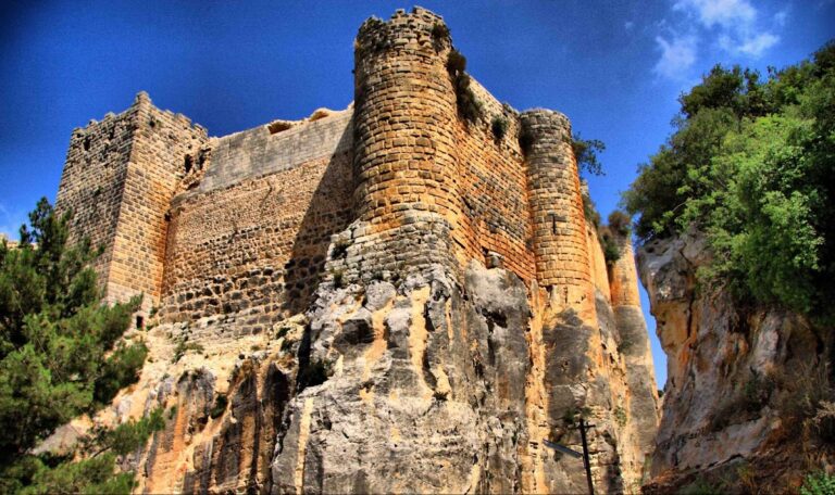
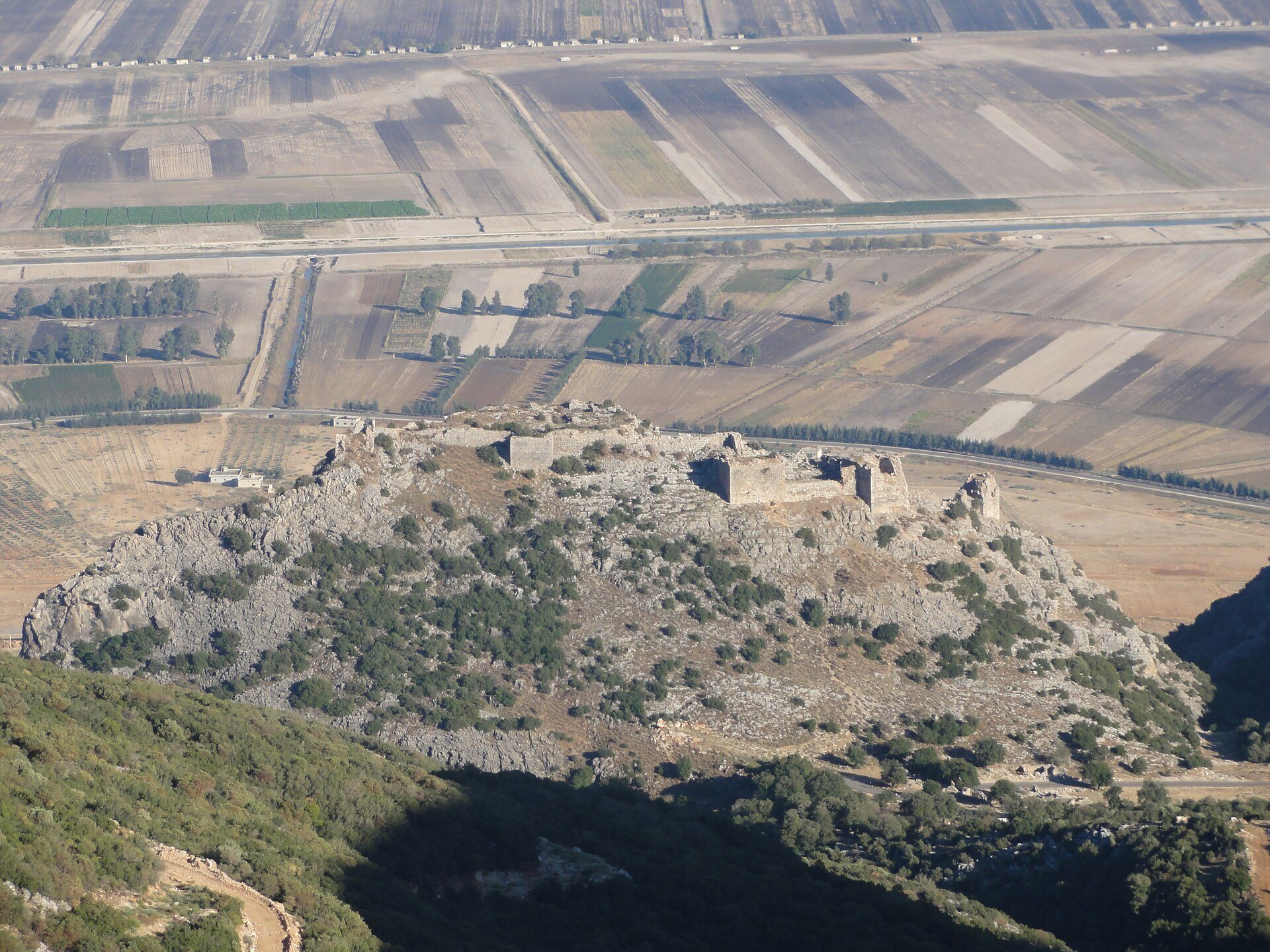
Bourzey Castle is a ruined fortress in Syria, on the eastern slopes of the coastal mountains overlooking the Orontes River and the Ghab Plain. The hill first served a strategic role during the Seleucid period, and the principal surviving castle works belong largely to the first Crusader phase of castle building, approximately 1100–1140. Known in different periods as Rochefort and Lysias, the stronghold guarded an important route and later formed part of the defensive system of the Principality of Antioch.
From the Seleucid period to Byzantine rule
During the Seleucid period, when the rulers of a Hellenistic empire founded after the conquests of Alexander the Great controlled the region, the hill was known as Lysias. Its position helped secure the connection between Laodicea and Apamea. Around 65 BC, the Roman general Pompey expelled Jewish insurgents from the fortification.
The Byzantines, the medieval continuation of the eastern Roman Empire, later established a fort on the hill. In 948–949, the commander Abu al-Hagar captured it for Sayf al-Dawla, the Hamdanid emir of Aleppo. The Hamdanids were an Arab dynasty that ruled parts of northern Syria and northern Mesopotamia during the tenth century. In 975, the Byzantine emperor John I Tzimiskes recaptured the fort from the Hamdanids of Aleppo.
Seljuk and Crusader control
After the Byzantine defeat at the Battle of Mantzikert in 1071, Muslim powers regained control of northern Syria. Aq Sunqur al-Hajib, the Seljuk governor of Aleppo, took possession of the castle in May 1090.
Crusaders from the Principality of Antioch captured the fortification around 1103, during the rule of Bohemond I, the first prince of Antioch. The Crusaders were Latin Christian forces and settlers who established states in the eastern Mediterranean during the medieval Crusades. The main surviving works are attributed on architectural and constructional grounds to this first Crusader building phase, dating approximately from 1100 to 1140. The castle was also called Rochefort and Lysias during its medieval history.
Saladin’s siege and later use
Saladin captured Bourzey Castle on 23 August 1188, after a siege that began on 20 August during his campaign following the Battle of Hattin. Saladin was the Muslim ruler and commander who founded the Ayyubid dynasty, which ruled Egypt and much of Syria during the twelfth and thirteenth centuries. The castle’s reputation for impregnability rested partly on the difficulty of bringing siege engines close to its walls.
Saladin’s troops failed at first to position their machines effectively. They then attacked the western wall in successive waves and eventually forced the garrison to surrender. The commander and seventeen members of his family were allowed to withdraw to Antioch. The medieval historian Ibn al-Athir also preserved a tradition that the commander’s sister-in-law revealed the Franks’ secrets to Saladin, helping to weaken the garrison’s resolve and contributing to the family’s survival.
Saladin did not retain the castle permanently. The Crusaders later reoccupied it, and it continued to serve an important role in the defensive system of the Principality of Antioch. After the Byzantine period, Ayyubid rulers added towers in an Arabic architectural style, while the Mamluks, the military ruling elite who later established a sultanate centered in Egypt and Syria, strengthened the southern towers.
Historical descriptions and survival
Ibn al-Athir described the northern and southern sides as effectively unassailable, the eastern side as difficult to climb, and the western valley as the area from which siege stones and arrows could reach the fortress. Yaqut al-Hamawi, a medieval geographer, characterized Barziya as a strongly fortified castle near the Syrian coast, standing on a high mountain surrounded by valleys.
The castle was damaged and partly destroyed by earthquakes and other natural forces. Its ruins preserve evidence of Byzantine, Crusader, Ayyubid, and Mamluk building phases. The site lies near the Shathah and Jorin areas, approximately 25 kilometres from Jisr al-Shughur. It is administratively associated with Hama Governorate and archaeologically recorded under the Latakia antiquities administration.
Remains
Mountain setting and overall layout
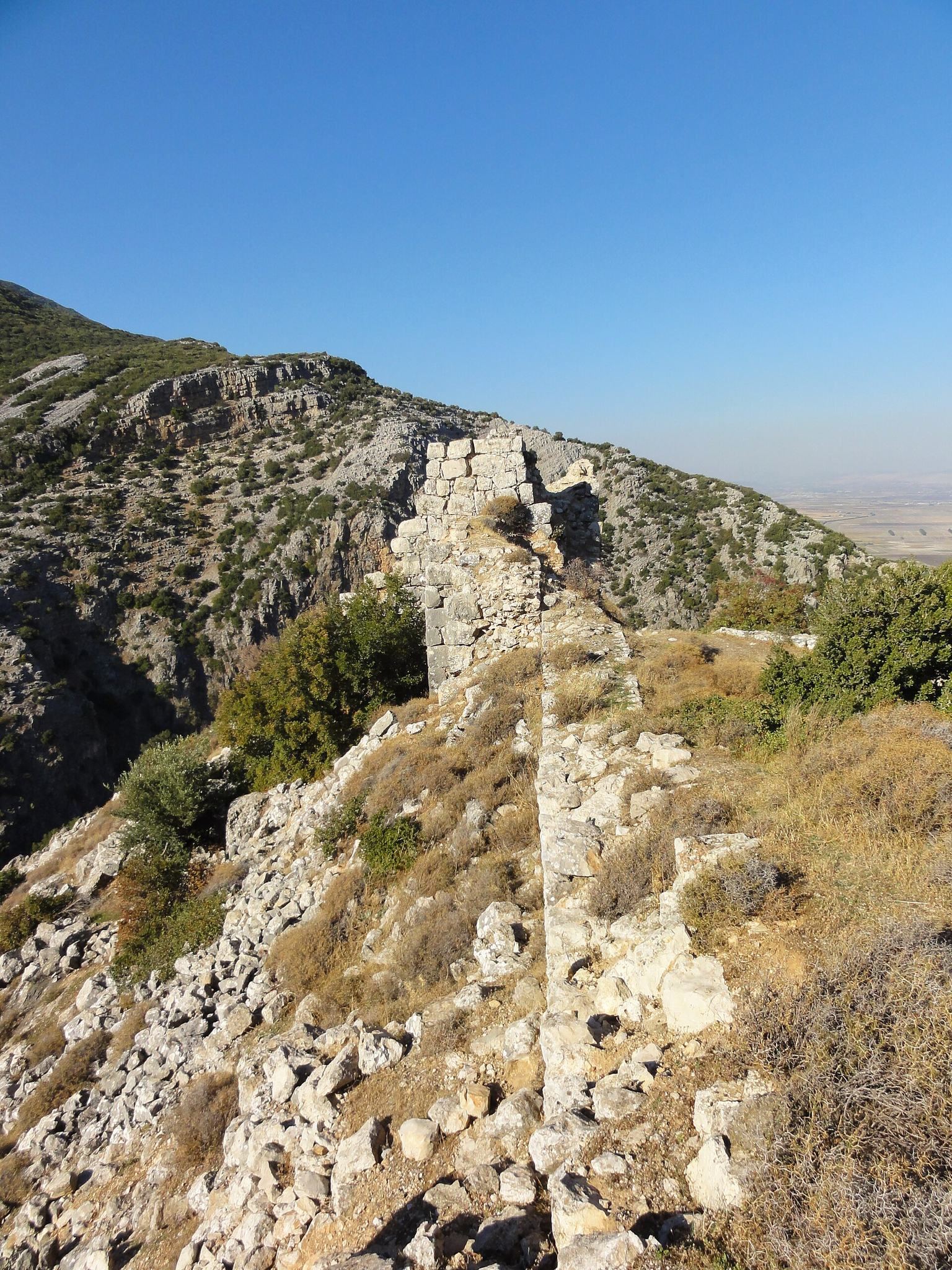
Bourzey Castle occupies a high, steep-sided mountain spur at the eastern edge of the coastal mountains. Its plan is broadly trapezoidal, measuring approximately 175 metres across the west, 50 metres across the east, and about 275 metres from east to west. The complex has an upper inner fortress and a lower outer enclosure, both enclosed by walls and towers.
Deep valleys and steep gorges protect the northern and eastern sides. The western slope is less steep and provides the most practicable approach, so the defenses are concentrated more heavily there. The approach reaches the western slope before rising steeply toward the fortress. The northern walls are thinner because the terrain reduced the need for massive fortification on that side.
Outer defenses and entrance
Western entrance
The principal entrance lies on the western side, where the natural approach is weakest. The original route passed between the first and second towers, turned right, and entered through the second tower. Later restoration altered the entrance arrangement.
Walls and towers
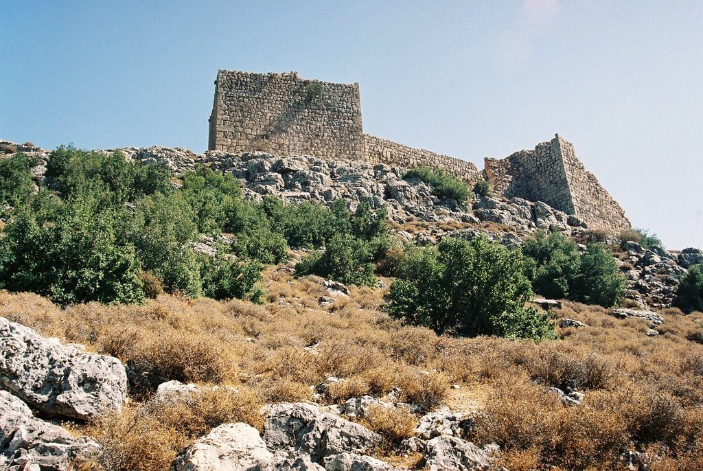
The outer walls are built of white limestone. Large, carefully worked stones form the western and southern sections, while the northern wall is thinner. Between towers 2 and 3, the western wall contains four arrow slits, narrow openings through which defenders could shoot while remaining protected.
The outer towers are integrated with the perimeter walls, while the inner towers belong to the central fortress. Large towers protect the western side. Towers 6, 7, and 8 defend the south, and tower 11 forms a large eastern watchtower overlooking the Ghab Plain. The northern towers are smaller and connect with the thinner northern wall. The castle also contains several arrow bastions and numerous defensive towers intended for observation, warning, and combat.
Inner fortress and water systems
Inner fortress
The inner fortress occupies the northwestern part of the complex. Inner walls and towers enclose it on the south, and its substantial masonry consists of large, finely worked stones set on firm bedrock. In places, the rock was cut down to increase the height of the defenses. The inner fortress has two levels. Its upper section rises considerably above the rock, whose edges were carved vertically.
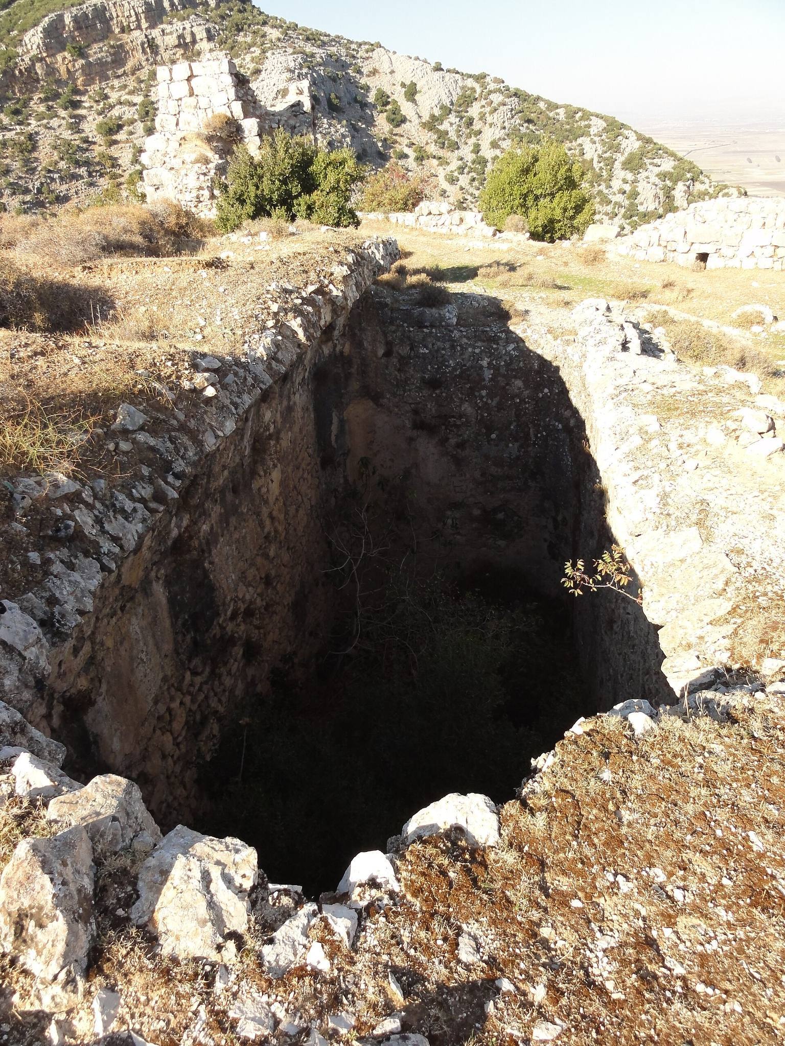
Rock-cut reservoirs
The lower level contains numerous rock-cut water reservoirs covered by pitched or gabled stone roofs. Similar reservoirs of different sizes occupy the area between the inner fortress and the outer walls on the eastern side, where they also have pitched coverings. Underground rooms form another part of the complex. These water installations and enclosed spaces survive among the principal remains of the fortified site.
Church and present condition
A small church stands within the castle area. The surviving complex is in a ruined condition, with sections damaged or destroyed by earthquakes and other natural forces. Its walls, towers, rock-cut reservoirs, underground rooms, and church preserve the physical results of successive Byzantine, Crusader, Ayyubid, and Mamluk interventions.