Ebla: An Ancient Syrian Kingdom and Archaeological Settlement

Site at a Glance
- Rating
- 4
- Popularity
- Very Low
- Country
- Syria
- Primary era
- Bronze Age
- Eras represented
- Bronze Age
- Civilizations
- Unclassified
- Site type
- City
On this page19 sections
History
Ebla is an ancient Syrian kingdom and settlement at Tell Mardikh in Syria, first established around 3500 BC and developed into a major political and commercial center. Its history is divided into archaeological phases known as Mardikh I, II, and III, followed by later settlements. During the third millennium BC, Ebla became one of the leading powers in Syria, with extensive diplomatic, military, and trading connections across the Near East.
Settlement and the First Kingdom
The earliest settlement belongs to Mardikh I, when Ebla grew from a small agricultural community. Mardikh II, dating approximately from 3000 to 2000 BC, includes the first and second Eblaite kingdoms. Ebla is often connected with the Kish civilization, a cultural sphere of East Semitic-speaking communities extending from central Mesopotamia into the western Levant.
The first kingdom lasted approximately from 3000 to 2300 BC. During its early phase, Mardikh IIA, Ebla acquired substantial public and royal buildings. Building CC and parts of building G2 belong to this period, with G2 apparently serving as a royal palace constructed around 2700 BC. By the later third millennium, the kingdom had become a major regional power.
Ebla entered a prolonged conflict with Mari toward the end of the early period. Mari gained the advantage under King Saumu, but King Kun-Damu defeated it in the mid-25th century BC. Ebla’s power declined after Kun-Damu’s reign. The surviving written archives begin during the reign of Igrish-Halam, when Ebla paid tribute to Mari and the Mariote king Iblul-Il conducted campaigns against Eblaite cities along the middle Euphrates.
Recovery, Expansion, and Administration
Ebla recovered under King Irkab-Damu around 2340 BC. The kingdom became prosperous again and launched a successful counteroffensive against Mari. Irkab-Damu also concluded a peace and trade treaty with Abarsal. During the reign of Isar-Damu, conflict with Mari continued. After Mari defeated Ebla’s ally Nagar, trade routes linking Ebla with southern Mesopotamia were obstructed. Ebla then allied with Nagar and Kish, and an army led by the grand vizier Ibbi-Sipish won a battle near Terqa. It attacked Armi and installed Ibbi-Sipish’s son, Enzi-Malik, as governor there.
At its greatest extent, the first kingdom controlled territory from Ursa’um in the north to the region around Damascus in the south, and from Phoenicia and the coastal mountains in the west to Haddu in the east. More than sixty vassal kingdoms and city-states were connected to it, including Armi, Hazuwan, Burman, Emar, Halabitu, and Salbatu. A vassal kingdom retained its own ruler while owing allegiance and other obligations to a stronger state.
The grand vizier was Ebla’s highest-ranking official and directed much of the administration, the council of elders, military campaigns, and diplomacy. Ibrium was the most powerful known vizier. He campaigned against Abarsal and held office for eighteen years, with warfare taking place in all but one of those years. The administration also included thirteen senior court officials and a bureaucracy of approximately 11,700 people. The queen shared responsibility for state affairs with the king, while the crown prince handled internal matters and a second prince dealt with foreign affairs.
Ebla’s administrative titles reflected a division between the capital and subordinate territories. A lugal was a governor directly answerable to the capital, rather than a king as the title generally meant in Mesopotamia. Fourteen lugals are recorded, suggesting that the kingdom was organized into fourteen districts, two in the capital and twelve elsewhere. The title ugula, meaning superintendent or administrator, was used by officials governing cities or tribal groups.
The king’s directly controlled economic hinterland, known to archaeologists as the chora, covered approximately 3,000 square kilometers. Agriculture, animal husbandry, manufacturing, and long-distance trade supported the kingdom. Trade reached Sumer, Mesopotamia, Egypt, Cyprus, the Syrian coast, and regions as distant as Afghanistan. Textiles were probably exported to Cyprus, perhaps through Ugarit, while river boats carried much of the trade with Mesopotamia, especially toward Kish. Ebla used treaties, political and military alliances, and marriage agreements to manage its relations with neighboring states. It recruited troops and mercenaries when military forces were required rather than maintaining a permanent army.
The Archive Period and First Destruction
The later phase of the first kingdom, Mardikh IIB1, is known as the archive period because royal cuneiform tablets survive from it. Cuneiform was made by pressing wedge-shaped marks into clay. Approximately 17,000 fragments from the royal archives were recovered and assembled into about 2,500 complete tablets, while other estimates distinguish around 4,000 tablets in the library and roughly 12,000 texts represented by fragments.
The texts include administrative and economic accounts, royal letters, treaties, legal material, agricultural and manufacturing records, school exercises, hymns, myths, and vocabulary lists. About 80 percent use the conventional Sumerian combination of logograms and phonetic signs. The remainder represent Eblaite, a previously unknown Semitic language, in cuneiform. Bilingual Sumerian-Eblaite vocabulary lists helped make these texts intelligible. Annual metal accounts and monthly linen accounts, together with changes in script, grammar, and the names of court members, have established a relative sequence of approximately fifty years even though the archive’s absolute chronology remains uncertain.
The archive period ended with the first destruction around 2300 BC. Palace G was burned, and the heat baked the clay tablets, preserving them. The identity of the destroyer and the precise date remain uncertain. Proposed explanations include campaigns by Sargon of Akkad or his grandson Naram-Sin, retaliation by Mari after the battle of Terqa, and a natural catastrophe. One interpretation places the fire around 2290 BC and finds that destruction was concentrated around the royal palace without convincing evidence of looting.
The Second Kingdom
The second kingdom, Mardikh IIB2, lasted approximately from 2300 to 2000 BC. A new local dynasty ruled Ebla, but it continued the traditions of the first kingdom, including its architectural style and the sanctity of earlier religious places. A new royal palace was built in the lower town, while written evidence became scarce apart from an inscription from the end of the period.
During this phase, Ebla included or maintained connections with Urshu north of Carchemish. Texts from the seventh year of Amar-Sin, around 2040 BC, mention a messenger of Ebla’s ensi, or ruler. The government of the Third Dynasty of Ur treated Ebla as a vassal, probably requiring tribute and formal recognition of Ur’s authority as a condition for trade.
The second kingdom ended in a second destruction by fire sometime between 2050 and 1950 BC, with 2000 BC used as a formal approximate date. Destruction evidence occurs outside the Temple of the Rock and around palace E on the acropolis. The cause is unknown. A possible Hurrian invasion around 2030 BC, led by the former Eblaite vassal Ikinkalis, has been proposed.
The Third Kingdom and Later Settlement
The third kingdom, Mardikh III, lasted approximately from 2000 to 1600 BC. It is divided into Mardikh IIIA, about 2000 to 1800 BC, and Mardikh IIIB, about 1800 to 1600 BC. Ebla was rapidly rebuilt as a planned city over the remains of Mardikh II, with new palaces, temples, streets, fortifications, and large public buildings.
The first known king of this period was Ibbit-Lim, who called himself the mekim of Ebla. The precise administrative meaning of this Eblaite royal title is uncertain. His father was Igrish-Khepa, and Ibbit-Lim’s name is considered Amorite by some scholars. The population of third-kingdom Ebla was probably predominantly Amorite.
From the beginning of the eighteenth century BC, Ebla became a vassal of Yamhad, the Amorite kingdom centered at Aleppo, and remained subordinate during the reign of Yarim-Lim III. King Immeya received gifts from the Egyptian pharaoh Hotepibre. An Eblaite princess married a son of King Ammitaqum of Alalakh, a member of a branch of the Yamhadite dynasty.
Ebla was destroyed for the third time by the Hittite king Mursili I around 1600 BC. Indilimma was probably its last king, although the seal of Maratewari, found in the western palace, has led Alfonso Archi to propose that Maratewari may have been the final ruler.
Ebla never regained its earlier importance. Mardikh IV, approximately 1600 to 1200 BC, was a small village mentioned in the records of Alalakh as a vassal of the Idrimi dynasty. Mardikh V, approximately 1200 to 535 BC, was a rural Early Iron Age settlement that later expanded. Mardikh VI continued until about AD 60, and Mardikh VII began in the third century AD and continued until the seventh century. The site was then abandoned.
Religion, Discovery, and Modern Damage
Ebla was a polytheistic state whose religious tradition was mainly North Semitic, while also incorporating Mesopotamian, Hurrian, and Sumerian deities. During the first kingdom, dead kings were worshiped. In the third kingdom, Hadad became the principal god, and Ishtar replaced Ishara as the most important goddess apart from Hadad.
Italian archaeologists from the University of Rome La Sapienza began excavating Tell Mardikh in 1964 under Paolo Matthiae. In 1968 they found a basalt votive statue dedicated to Ishtar and inscribed with the name of King Ibbit-Lim. Its inscription identified the mound with ancient Ebla, which had previously been known from Lagashite and Akkadian records. Claims that the discovery proved connections with Yahweh, the biblical patriarchs, Sodom, or Gomorrah arose from preliminary readings and speculation and are now widely discredited. Ebla is generally studied as an independent civilization.
Excavation and research stopped in March 2011 because of the Syrian civil war. After opposition forces took control, the site was used as an observation point and was heavily looted. Tunnels were dug, a crypt containing human remains was disturbed, and soil was removed from nearby areas for ceramic linings used in bread ovens. The Syrian Arab Armed Forces captured the site on 30 January 2020 during the fifth Northwestern Syria offensive. Remote-sensing evidence indicates severe damage from military activity and associated looting. In 2024, archaeologists from Sapienza University of Rome conducted a recovery and restoration campaign, assessing the damage, restoring some buildings, including the Sanctuary of the Deified Ancestors, and discovering a previously unknown basalt royal statue dating to the second millennium BC.
Remains
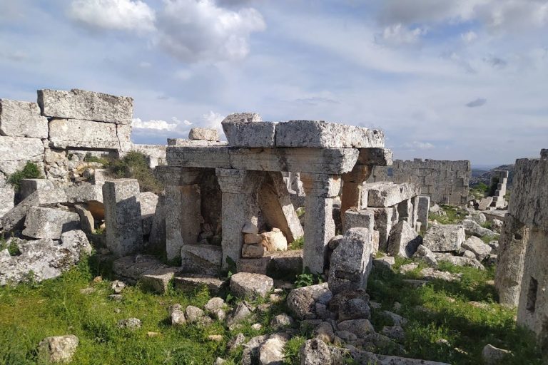
Ebla was a tell, an artificial mound formed by successive settlements, with a raised central acropolis and a lower town. During the first kingdom, the settlement covered approximately 56 hectares and was enclosed by mud-brick fortifications. Four districts occupied the city, each with its own gate in the outer wall. During the third kingdom, the settlement expanded to nearly 60 hectares and was protected by a fortified rampart with gates divided into two chambers.
First-Kingdom Acropolis
Palace G
Palace G occupied the southern and southwestern part of the acropolis and formed the principal building of the archive-period city. Its western administrative sector contained a large courtyard, a columned entrance, and a reception hall with a throne platform made from sun-dried brick. Earlier construction in Mardikh IIA included building CC and parts of building G2, apparently a royal palace built around 2700 BC. Palace G was later constructed over G2.
The palace combined royal, administrative, storage, and archive spaces. Imported materials included more than 20 kilograms of lapis lazuli, probably brought from Afghanistan, fragments of diorite vessels, and Egyptian alabaster. Archive rooms included L.2586, L.2712, L.2769, L.2764, L.3769, L.2875, and L.3764. Room L.2769 is identified as the royal library. The tablets had been arranged by subject, size, form, and content. Larger examples were placed on wooden shelves and fell when the palace burned, leaving patterns that allowed excavators to reconstruct their original arrangement. The collection therefore served at least partly as a library rather than only as an administrative archive.
Temples and Royal Burial
The acropolis contained one of Ebla’s two temples dedicated to Kura, known as the Red Temple. The other Kura temple stood in the southeastern lower town and is known as the Temple of the Rock. The first-kingdom kings were generally buried outside the city. The last ten kings, ending with Irkab-Damu, were buried at Darib, while earlier kings were placed in a royal mausoleum at Binas. Only one first-kingdom royal tomb has been discovered within Ebla.
Hypogeum G4
The royal tomb within palace G, designated hypogeum G4, is an underground burial chamber probably dating to the reign of Isar-Damu. It lies almost 6 metres beneath the western part of the palace and was excavated between 1992 and 1995. Two connected rectangular rooms have lime-plaster floors. The eastern room, L.6402, is 4 metres wide and more than 3.5 metres long, while the western room, L.5762, measures 5.20 metres long and 4 metres wide. Both rooms are oriented from east to west.
Second-Kingdom Buildings
Palace P5 and Temple D
During the second kingdom, palace P5 was constructed in the lower town northwest of the acropolis. It continued in use during Mardikh IIIA and was later replaced by the Intermediate Palace during Mardikh IIIB. Temple D was built over the destroyed Red Temple, continuing the use of this religious area through a later phase of the settlement.
Third-Kingdom Palaces and Temples
Palace E and the Acropolis Temples
Third-kingdom Ebla was laid out with new public buildings, palaces, temples, streets, and fortifications. Palace E stood on the acropolis during Mardikh IIIB. In area D, a temple dedicated to Ishtar was built above the former Red Temple and Temple D. A second Ishtar temple occupied the northern lower town, while the earlier Temple of the Rock was replaced by a temple dedicated to Hadad.
Western Palace and Other Public Buildings
Other third-kingdom buildings included the vizier’s palace, the Temple of Shamash or temple N, the Temple of Rasap or temple B1, and the northern palace. The western palace in area Q was built around 1900 BC and excavated in 1978. It covered more than three-quarters of a hectare and stood above a royal necropolis.
Royal Necropolis
The royal necropolis beneath palace Q contains several underground tombs, of which three have been excavated. The Tomb of the Princess dates to approximately 1800 BC and is the oldest and smallest excavated tomb of the third kingdom. The Tomb of the Cisterns is the most damaged. The largest is the Tomb of the Lord of the Goats, whose occupant is unknown. King Immeya is a possible occupant because a silver cup bearing his name was found there.
Inscriptions and Recent Preservation
Only the torso survives from the basalt votive statue of King Ibbit-Lim discovered in 1968. Its 26-line Akkadian cuneiform inscription mentions Ebla twice and established the ancient name of Tell Mardikh. The palace archives contain texts in both Sumerian and Eblaite, linking the surviving written material with the political and administrative structures of the settlement.
Military trenching, looting, and the movement of archaeological soil altered the central mound, acropolis, palace areas, fortifications, and lower town. The 2024 recovery campaign restored some surviving buildings, including the Sanctuary of the Deified Ancestors, and recovered a new basalt royal statue dating to the second millennium BC.
Nearby sites