Boldogkő Castle: A Medieval Fortress in Hungary
Site at a Glance
- Popularity
- High
- Country
- Hungary
- Primary era
- Medieval
- Eras represented
- Medieval, Early Modern, Modern
- Civilizations
- Austria-Hungary, Habsburg, Hungarian
- Site type
- Military
- Remains
- Castle
On this page24 sections
History
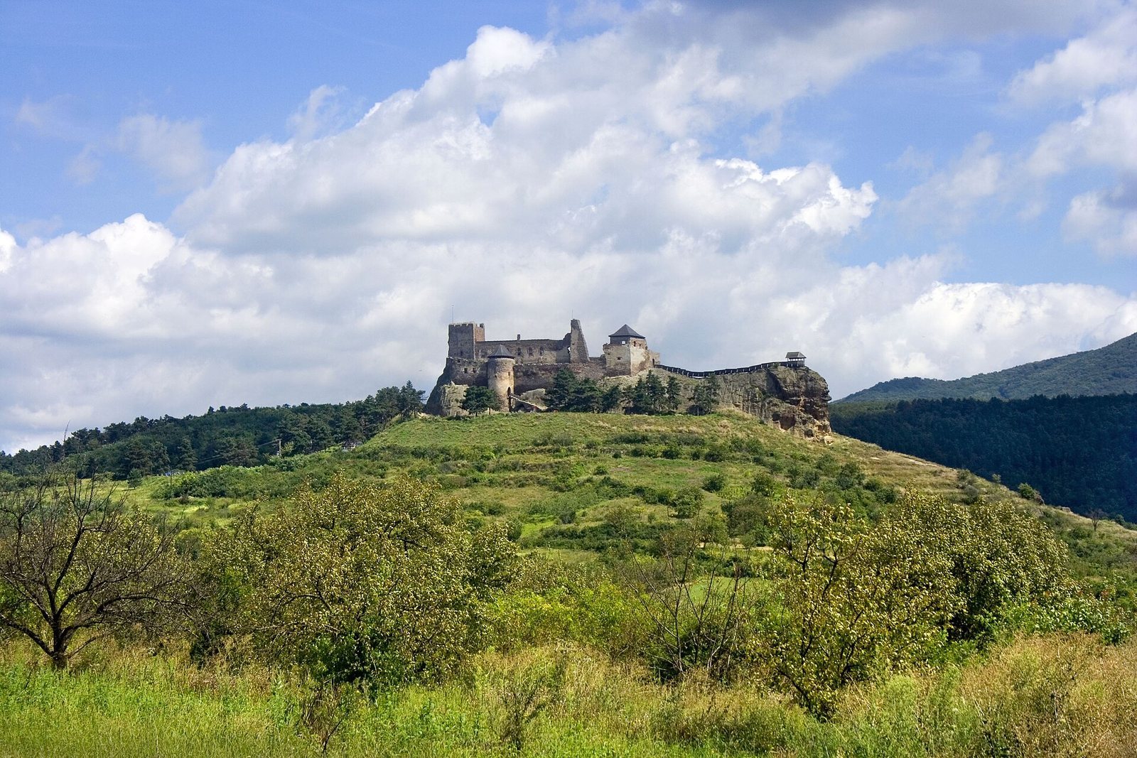
Boldogkő Castle is a medieval Hungarian fortress near Boldogkőváralja in Hungary, above routes through the Hernád Valley. Its earliest remains probably date to around 1280, during the expansion of stone-castle building after the Mongol invasion. Its position gave it military and economic importance, though the identity of its founder remains uncertain.
Origins and the Aba lords
A local legend links the castle to Béla IV’s escape from the Mongols after the Battle of Mohi, a major Hungarian defeat in 1241. In the story, an old fruit-drying master named Bodó helped the king and received land on condition that he build a castle. Bodó’s seven daughters married men who each worked on the building for a year, completing it in seven years. The tale connects the name Boldogkő with the daughters’ happiness, but it is a foundation legend rather than a confirmed account of the castle’s construction.
Two possible founders have been proposed: Tyba, son of Jaak of the Tomaj noble lineage, and a member of the Aba lineage, particularly the regional lord Aba Amadé. A charter from about 1295 refers to Boldua and records King Andrew III granting it to Tyba in exchange for Rezi and Zsid, which Tyba had earlier received from King Ladislaus IV. An earlier charter, from around 1280, describes a similar exchange but does not name Boldua. Neither reference securely identifies Boldogkő Castle.
From the early fourteenth century, the castle belonged to the Aba lords, whose influence grew after the Árpád dynasty ended. Aba Amadé was killed during unrest in Kassa in 1311. His sons initially submitted to Charles I of Hungary under an agreement made that October, but fighting resumed. After Charles’s victory at Rozgony, the sons retained Boldogkő and Nevicke and an office in Ung County. By 1317 their power had been reduced to that county. They rebelled again, were defeated, and left the kingdom; the crown confiscated their estates.
Royal grants and fifteenth-century rebuilding
After the confiscation, Boldogkő passed to the Drugeth family, loyal to Hungary’s Angevin rulers. Philip Drugeth held the castle, followed by William around 1339, and the family probably owned it until 1351. They are thought to have expanded the upper fortress. Ownership after the Drugeths is uncertain until the castle appears among royal possessions in 1383 and again in 1388. That year, King Sigismund pledged it and its dependent villages to Peter Cudar, a former senior royal official, for 8,838 gold florins. Cudar’s heirs kept the pledge after his death. Rebels later seized the castle, and Peter Perényi retook it for the king in 1403.
After 1422, Boldogkő belonged to the Serbian ruler Stefan Lazarević and, from 1427 to 1453, to George Branković, along with Tállya, Tokaj, Regéc, and Munkács. The castle returned to the royal holdings after 1456. In 1461 Matthias Corvinus granted it and its associated lands to the Parlagi brothers, Paul and Ladislaus. Kassa held it as security from 1467 to 1471. A royal letter of 1464, associated with its transfer to Imre Szapolyai, contains the earliest known use of the name Boldogkő. By 1471 it was again described as a royal castle, with several villages among its dependent properties.
Major building work enlarged the fortress during the fifteenth century. It later passed to the Szapolyai family. Before 1526, John Szapolyai gave it to George Tomori as a baptismal gift. Mátyás Dévai Bíró, who later became a Reformation leader, served as the castle’s chaplain while still a Catholic priest.
Sixteenth-century contests and changing owners
After the Battle of Mohács in 1526, Boldogkő repeatedly changed hands during the struggle between Ferdinand I and John Szapolyai, rival claimants to the Hungarian crown. Ferdinand granted it to Stephen Báthory in 1527. John retook it by siege in 1528, together with Regéc. That August, Ferdinand’s supporters Gáspár Serédi and Captain Ferenc Bebek besieged Boldogkő for six weeks. They probably compelled its castle commander to surrender and accept an agreement not to attack them. By 1530, Tamás Nádasdy administered the fortress for John and repelled attempts by Bebek and Rupert Herberstein to recapture it. Boldogkő later belonged to Egyed Tomory and Cardinal George Martinuzzi, before Ferdinand’s forces captured it in 1537 under Leonard Fels.
Ferdinand exchanged the castle with Ferenc Patóchy in 1542 for Gyula Castle. Patóchy’s daughter Zsófia married Baron George Bebek, and Boldogkő passed to the Bebek family in 1556. George established a counterfeit-coin workshop there. In 1560, he exchanged the castle with István Mihály Sárközy for the captured Ottoman commander Amhát Pasha.
Ownership then passed from Sárközy’s son to the Serényi family. In 1578 Rudolf II confirmed inheritance rights for Gábor and Mihály Serényi and their wives’ descendants; the property eventually went to Mihály’s younger brother Ferenc and his heirs. A dispute over Sárközy’s will led to prolonged litigation, during which the castle was entrusted to Miklós Perlaky. Ferenc Serényi sold it in 1612 to György Palochay Horváth. After György’s death in 1617, his son Gábor and then grandson István inherited it. The castle was probably pledged to Mátyás Szikszay from 1627, belonged to János Várkonyi from 1630, and later returned to the Palochay family.
Seventeenth-century conflict and destruction
In 1663, Upper Hungarian counties decided at Kassa to raise forces against the Ottomans, and troops gathered at Boldogkő under Gábor Bakos. The castle itself was not captured in 1666, although fighting in the surrounding area is considered likely. It stood away from the main Ottoman frontier, but clashes with raiding parties heading toward Upper Hungary are recorded.
János Terjék took the castle on 29 June 1667 on behalf of Archbishop György Szelepcsényi and managed it for nearly a decade. Gábor and István Palochay formally pledged the fortress and its associated properties to Szelepcsényi in 1671, and he retained it until his death in 1685. Kuruc, or anti-Habsburg insurgent, forces besieged Boldogkő in 1674 and 1675 but failed to take it. Captain Ferenc Becskereky probably contributed to its defense. The emperor ordered several castles, including Boldogkő, to be made unusable to discourage rebellion. The measures may have involved explosions, fires, or demolished defenses, but the damage at Boldogkő did not prevent continued use.
Imre Thököly’s forces captured the castle in 1678, and Ferenc Fajgil became its captain. Thököly announced plans to rebuild the castles under his control in 1683, but an armistice with Vienna protected Szelepcsényi’s estates and stopped the work. Under the archbishop’s will, the Esztergom Chapter inherited Boldogkő in 1685. After Ottoman governor Ahmed Pasha of Várad arrested Thököly that autumn, garrisons in occupied castles surrendered to advancing imperial troops. Boldogkő passed to Habsburg forces without a fight.
In 1701 an imperial detachment blew up parts of the defenses, including the old tower, residential tower, and palace. The ruined fortress played no military role in the Kuruc War of Independence. In 1715 Jesuits from Levoča used its buildings to store grain, which helped keep the walls from being dismantled.
Later use, restoration, and investigation
Royal councillor Gábor Péchy bought the castle in 1753. He first lived in a manor below the fortress, then in a Baroque mansion he built in the valley village in 1768 rather than in the inconvenient ruin. In the late nineteenth century, the Péchy family rebuilt some collapsed wall sections and altered palace openings with pointed Gothic-style frames. These changes obscured the earlier appearance of many windows and doors. After Count Manó Péchy died in 1889, his daughter Jequelin, wife of Rezső Zichy, inherited the property; the Zichy family held it until nationalization.
The castle and a 4,000-cadastral-hold estate were nationalized in 1945. Surveyors made a detailed record of the ruins in 1952, and archaeological work began in 1963 under Katalin Kemenczeiné Végh. Investigation continued in later decades and resumed on a larger scale in 2002. Conservation and reconstruction from 2009 onward restored parts of the lower-castle gate, northern defenses, and dry mill, while adding protective roofs and a wall walk. The castle and its surroundings have formed part of the Zemplén Landscape Protection Area since December 1984.
Remains
Setting and overall plan
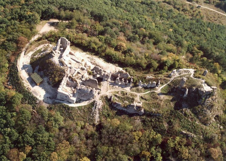
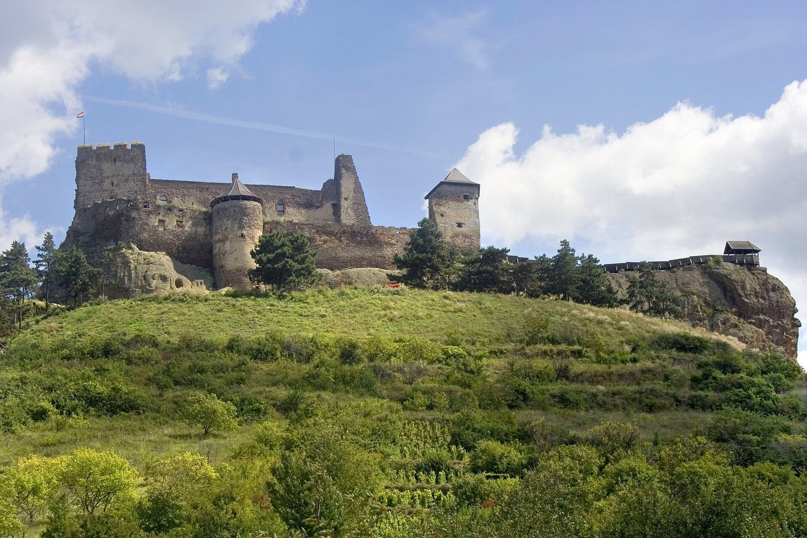
The castle stands about 245 metres above sea level on a rocky spur east of the Hernád Valley, near Boldogkőváralja. The ridge, called Bodókő, runs north to south and consists of andesite tuff, volcanic rock formed from consolidated ash and fragments. The fortress has an upper and a lower castle. The upper section follows the ridge crest, east of the lower yard and about 10 to 11 metres higher on average. Its main features include the upper yard, the old tower, a triangular residential tower, and the palace. Long-established viticulture probably contributed to the loss of the region’s original oak woodland. Around abandoned plots near the village, woodland plants are returning alongside steppe vegetation; local habitats include woodland, scrub, dry grassland, and rocky slopes.
Upper castle
Old tower
The oldest surviving structure is the thirteenth-century old tower, which initially stood alone and also served as a residence. Its interior measured about 5.5 metres square, and parts of its walls reached 2.8 metres in thickness. The northwest corner survives, but erosion has badly damaged several walls. Little remains of the south wall, so the original entrance cannot be located with certainty. A posthole near the east wall may indicate an earlier access stair, possibly a spiral stair. A small later bastion, about 8 metres long and 2.85 metres wide, stood close to the tower’s east side.
Southeast room
A room with brick supports adjoined the tower at its southeast corner and may have extended east to the outer wall. Plaster traces remain on one wall, and the floor was the smoothed rock surface. A later stone-walled room occupied the southeast corner of the old tower.
Rock-cut dungeon
South of the adjoining room, a dungeon was cut 5.6 metres into the ridge and lined with brick. Its stone roof has collapsed, and access may once have been through that roof. Two coins were recovered inside, including one from the Rákóczi period dated 1703. Another coin, issued under Ferdinand and dated 1552, came from the rock surface south of the dungeon.
Cistern
North of the old tower is an enclosed cistern, a structure for storing water, about 26 metres deep and bounded by walls on three sides. It was probably built during the Drugeth period. It may first have been dug as a well, but the porous rock let water escape too quickly. The shaft was later used partly to gather rainwater and partly filled with water carried up to the castle.
Residential tower
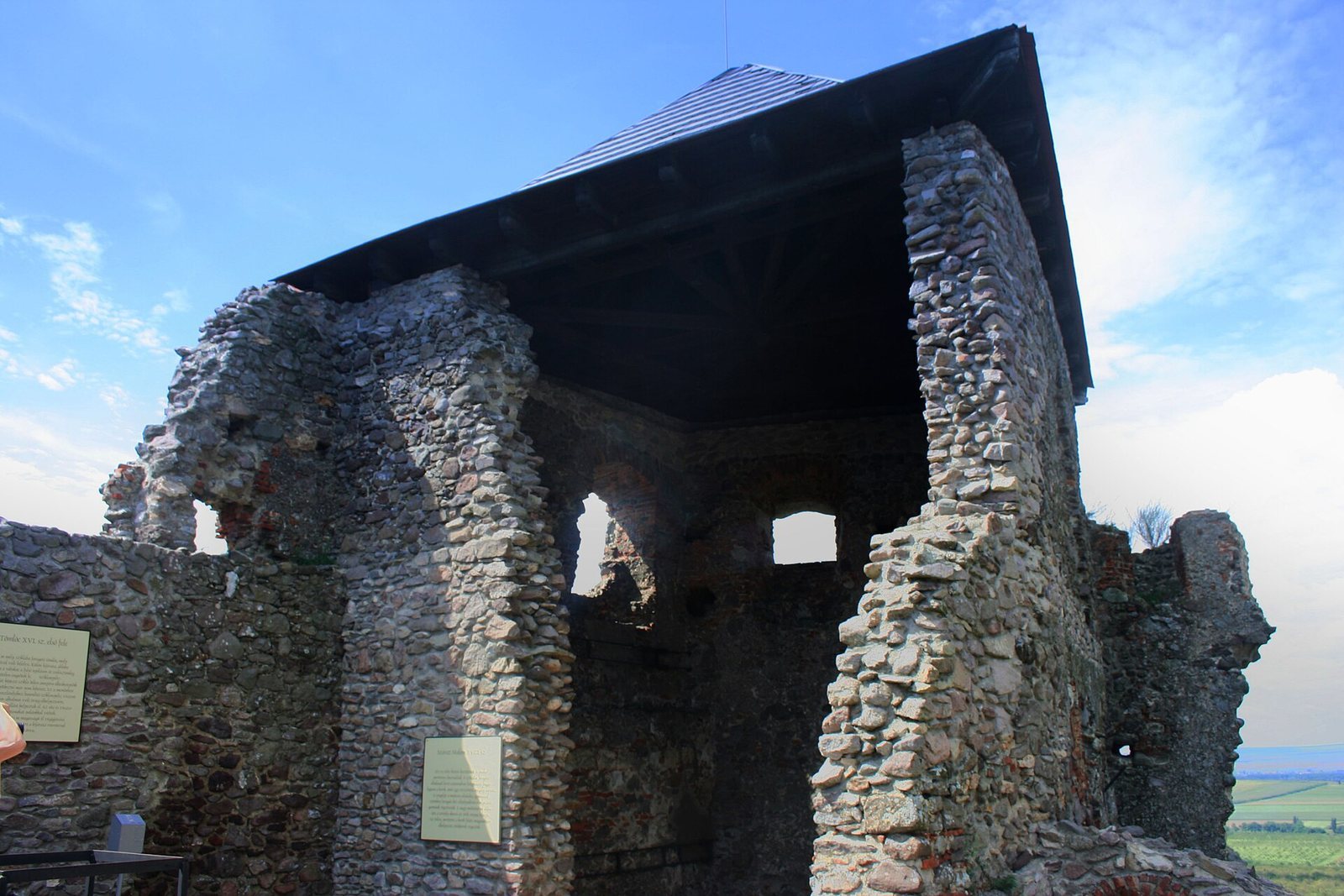
At the north end of the upper castle, a triangular-prism-shaped residential tower protected the palace from the north. Its walls survive, but its curved stone ceilings have collapsed. At the interior’s north end, traces of a circular structure founded on the rock may mark a spiral stair to the upper floors. During a later alteration, stone and sandy earth were packed inside the tower.
Palace
The partly preserved palace has four narrow openings near ground level in its outer wall, each about 20 by 120 centimetres. These were followed higher up by flat-stone windows with shallow arches, now blocked. The present windows have pointed frames added in the nineteenth century. The earliest known interior vault, dating no earlier than the sixteenth century, has collapsed. Fill on the east side is shallow, while a thicker layer on the west helped level the sloping rock. A partition divided the ground floor into a smaller north room and a larger south room. Debris above the floor included an iron spoon, pottery fragments, half a millstone, and an elongated grinding stone.
Eastern curtain wall
An outer curtain wall, a fortified wall enclosing or joining parts of a castle, ran beside the palace’s east side and can still be traced toward the old tower, although it is badly eroded. A defensive barrier of upright stakes may have preceded the wall. A gate may have stood near the palace corner.
Later towers and defenses
Fifteenth-century additions included an irregular four-sided tower on the south, with a defensive stake wall attached, and a horseshoe-shaped gate tower linked to a defensive wall. An outer wall was also built around the palace on its east side. These additions altered the earlier arrangement, which had centered on the old tower.
Lower castle and defenses
Gate bastion
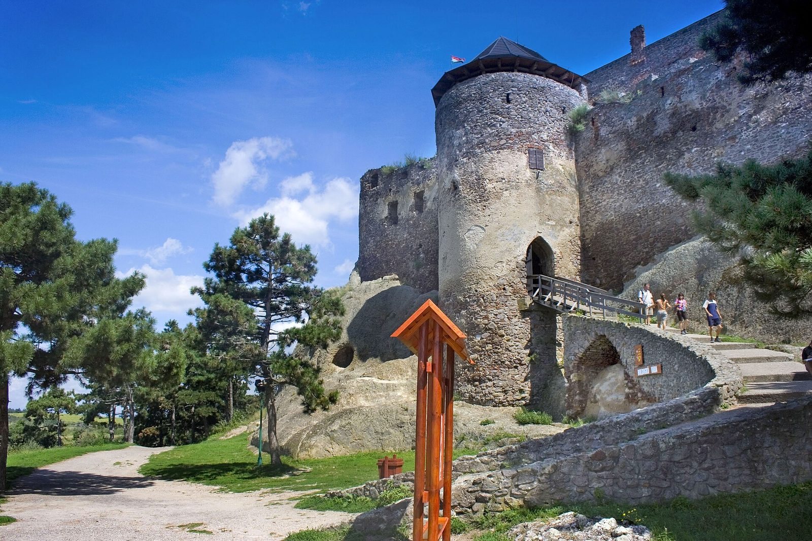
Entry to the lower castle passes through a semicircular bastion, a projecting defensive structure. A drawbridge once stood at the entrance. The bastion has narrow openings, or loopholes, for observation or firing; its openings facing outward and toward the yard now have pointed frames. Excavation showed that the foundations descend about 1.5 metres. Postholes at the yard entrance may mark an earlier wooden defense, perhaps a barrier of upright stakes.
Lower yard
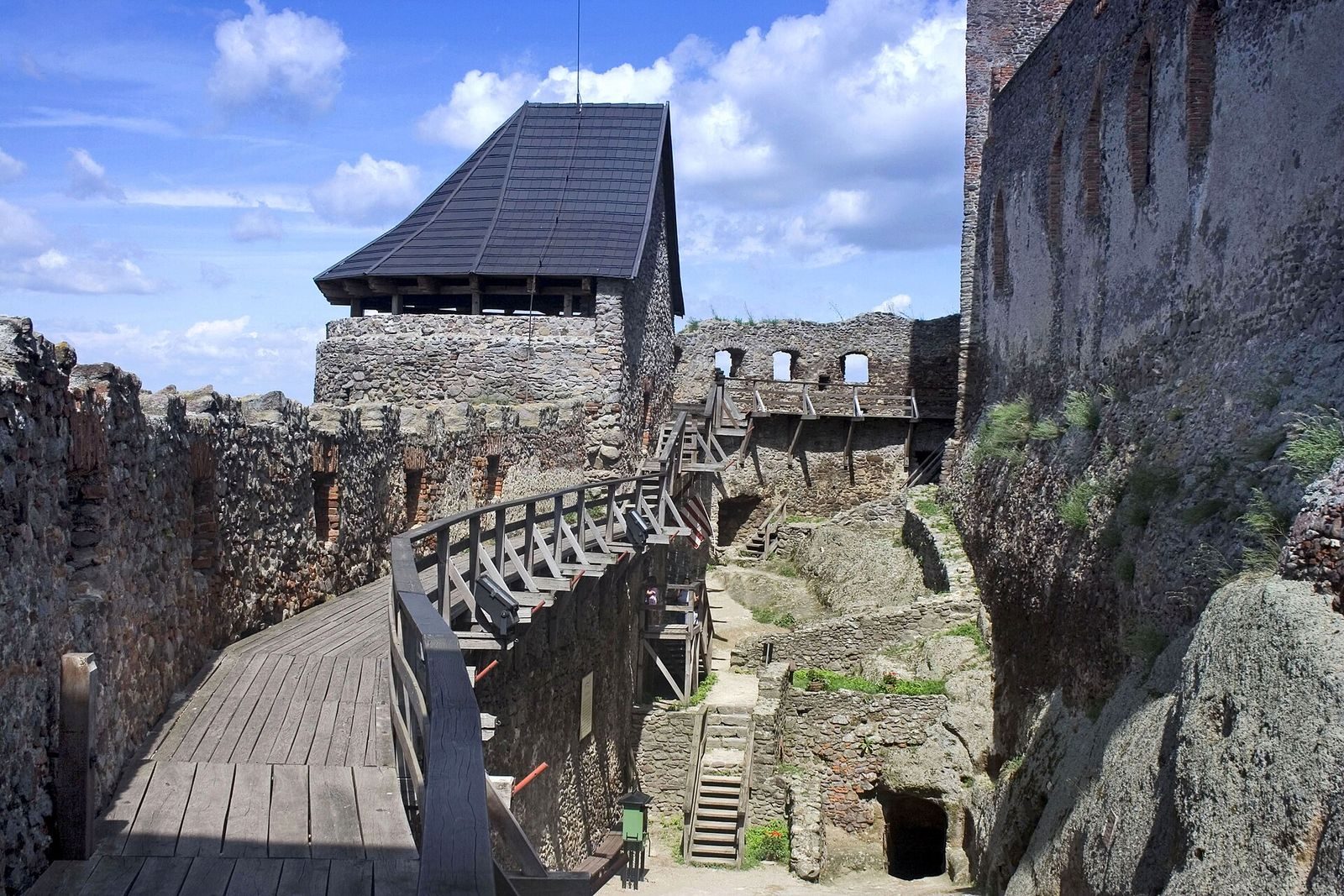
The lower yard, also called the wall corridor, occupies the space between the inner and outer walls. A wall walk, a passage along the top of a defensive wall, follows the thick western outer wall, whose loopholes narrow toward the exterior. At the northeast corner, a descent leads to the cellar beneath the palace. A steep stair cut into the rock at the southeast corner rises about eight metres to the upper yard. More than a hundred postholes in the yard’s western part may mark an earlier structure, probably a double stake barrier filled with earth, which preceded the western wall.
Truncated bastion
At the north end of the lower yard, the truncated bastion continues the western outer wall and meets the palace’s triangular bastion on the east. It probably belongs to the fifteenth-century defenses. Two low gun openings were found in its wall, with outward-narrowing loopholes and windows above, accessible from a wall walk. A wall beside the cellar entrance bounds the bastion to the south; it is about 60 centimetres thick and 1.4 metres high. Interior walls divided the space into rooms.
Rubble inside the bastion, possibly deposited by the 1701 explosion, contained iron tools and stove tiles. One unglazed tile painted with a mounted soldier helps date part of the material to the second half of the fifteenth century. Excavation also uncovered a flat-bottomed basin carved horizontally into the rock, about 120 by 200 centimetres, with a small channel on its southeast side. It may have been used to wash copper ore. Nearby, a furnace cut into the tuff may have smelted copper ore and tin. A bronze casting and iron slag point to bronze production and the working of iron; the casting method reflects sixteenth-century practice.
Cellar
A cellar with four branches lies below the truncated bastion. Its entrance is in the lower yard, beside the gate opening.
South tower and dry mill
The irregular four-sided south tower forms the lower yard’s southern boundary. Narrow openings in its upper walls were later blocked. Its entrance from the lower yard was closed, after which the tower could be entered only from the east, through a doorway facing the upper yard. A basin and channels cut into the rock, together with broken millstones found during excavation, suggest that a dry mill operated there. A dry mill works without water power.
Southern dungeon and rock projection
A deep dungeon lies in front of the south tower. A passage leads from this area toward the observation bastion at the tip of the rocky ridge. A lookout was later established on the rock projection at the former bastion’s location.