Beerfurther Schlösschen: Medieval Tower Castle in Reichelsheim, Germany


Site at a Glance
- Rating
- 4
- Popularity
- Very Low
- Country
- Germany
- Primary era
- Medieval
- External website
- Open
- Eras represented
- Medieval
- Civilizations
- Holy Roman Empire
- Site type
- Military
- Remains
- Castle
On this page10 sections
History
Beerfurther Schlösschen is the ruin of a medieval tower castle in Reichelsheim, Germany, built on a wooded spur above Beerfurth in the Odenwald. Its date is uncertain, although its construction technique may point to a predecessor of nearby Reichenberg Castle, whose origins date to around 1200.
Ownership and possible beginnings
The castle’s early history remains uncertain. Before the Counts of Erbach acquired the allodial territory of the upper Gersprenz Valley at the beginning of the thirteenth century, landholding in the area was divided among several owners. An allodial territory was land held as hereditary property rather than as a feudal tenure dependent on a superior lord. The builders of Beerfurther Schlösschen may therefore have belonged to an earlier owning family, possibly the Lords of Crumbach, a medieval local noble family.
Ruins and archaeological investigation
The first known documentary mention dates to 1740. At that time, residents of Beerfurth removed stones from the ruins to build a schoolhouse. The government of Erbach prohibited the removal, apparently with limited success.
A land survey of Kirch-Beerfurth made between 1853 and 1857 showed the site as a considerably oversized building with an unusual plan containing several projections. The survey labelled it “Kirchbeerfurfurth Castle,” although that designation appears to have been crossed out soon afterward.
Archaeological excavations began in 1887 under Eduard Anthes, a German archaeologist and historian. Only a few finds were recovered, and this led to the possibility that the castle had remained unfinished. The limited evidence has left both its date and its original builders unresolved.
Remains
The fortified core
Square tower
The castle stood on a projecting ridge, or spur, at about 363 metres above sea level, east of Kirch-Beerfurth, south of Hutzwiese, and near the Vierstöck inn. The wooded spur overlooks the Gersprenz Valley and forms the northwestern end of the 404-metre Burgberg. At the centre of the fortification was a square tower measuring 14 metres on each side. Its walls were approximately 2 metres thick, and the tower base survives.
Ring wall
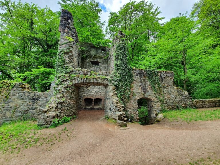
A ring wall, meaning a defensive wall enclosing the central part of a castle, surrounded the tower. It stood about 5 metres away on the south, east, and north sides, and about 10 metres away on the west. Parts of the wall’s infill masonry remain, along with sections of its inner facing made from small ashlar blocks. These surviving portions have been secured.
Earthworks and outer defences
Neck ditches
Several ditches and ramparts shaped the castle’s defensive setting. On the eastern side, a neck ditch ran from the south toward the northeast. A neck ditch is a transverse ditch cut across the narrow connection between a fortified spur and the higher ground behind it. A second ditch lay about 7 metres farther east and is now almost filled in. The northwest side retains the ring wall, tower base, and large neck ditch.
Outer bailey and spur ramparts
Anthes’s excavations identified parts of an outer bailey beyond the eastern neck ditch. An outer bailey was a subsidiary enclosed area outside the castle’s principal defensive core, and only weak traces of this feature remain visible in the terrain.
Three clearly visible, parallel ramparts and ditches follow the castle and the line of the spur. They probably protected the southern side of the stream valley leading toward the Gersprenz Valley. Together with the tower base, ring-wall remains, and neck ditches, these earthworks preserve the broad defensive arrangement of the medieval fortification.