Azetium: An Ancient Peucetian Settlement in Italy
Site at a Glance
- Popularity
- Medium
- Country
- Italy
- Primary era
- Classical
- Eras represented
- Classical
- Civilizations
- Roman
- Site type
- Settlement
- Remains
- Town
On this page17 sections
History
Early occupation and urban growth
Azetium was an ancient Peucetian settlement on Torre Castiello hill near present-day Rutigliano, Italy. A stable settlement spread across the hill from the 4th century BC, and the site preceded the medieval settlement in the area. Its name probably derives from the Paleo-Italic form Ausetium; Ehetium, Ezetium, Azetium, and the Italianized Azezio are also associated with it.
Human activity on the hill began in the Neolithic and continued through the Final Bronze Age, from the 11th to the 8th centuries BC, and the Iron Age. Azetium developed an urban character during the classical period, as urbanization spread through Peucezia, the territory of the Peucetians. Regional conflicts between Taranto and the Messapian and Peucetian communities culminated in the campaign of Alexander the Molossian, king of Epirus, in 334–332 BC.
Hellenistic prosperity and Roman connections
From the 4th century BC through the Hellenistic period, the settlement reached its greatest urban and economic expansion. In the 3rd century BC, agriculture, trade, and routes between inland communities and the coast supported stable social and economic conditions. Azetium was then a civitas sociorum, an allied community within Rome’s political system.
Many Peucetian settlements declined amid the disruption that followed the Second Punic War, but Azetium remained prosperous in the 2nd century BC and at least until the middle of the 1st century BC. During the Roman Republican period, the town benefited from an inland route known as the mule track of Strabo, identified with the Via Minucia. It offered an alternative to the coastal Via Traiana and connected Bitonto with Egnazia through Caelia, now Ceglie del Campo, Azetium, and Norba, now Conversano. Secondary tracks led toward the Adriatic; Cala Paduano, between Torre a Mare and Mola di Bari, is considered a possible port outlet for the settlement.
Roman rule and later contraction
After the Social War of 91–88 BC, a conflict between Rome and its Italian allies that led to the extension of Roman citizenship, evidence from Azetium shows a marked break in activity. A hoard of 80 late Republican silver denarii was buried around this period of crisis. Following Rome’s reorganization of Italy and the grant of citizenship in 90–88 BC, Azetium’s inhabitants were probably enrolled in rural voting tribes. Peucetian communities may have been assigned collectively to the Claudia tribe, and Azetium may consequently have become a municipium, a community with municipal status in Rome’s civic system. This possibility is supported in part by Pliny the Elder’s listing of the Aezetini among Italian communities.
From the later 1st century BC, changes to settlement patterns and local production accompanied a gradual contraction. The name Ehetium appears in imperial-era geographical references, including the works of Pliny the Elder and the Ravenna Cosmography. It also appears in the Peutinger Table, a map of Roman routes dating to the 3rd–4th centuries AD, which places it between Celia and Norve, and in the geographical work associated with the medieval writer Guidone. Settlement continued sporadically into the late imperial period, including the 5th–6th centuries. The hill was eventually abandoned as a settlement and turned to agricultural use.
Rediscovery and modern investigation
Domenico Romanelli first reported the site’s location in 1818. Early 19th-century notices largely concerned chance discoveries, finds with uncertain locations, museum acquisitions, and objects seized in connection with clandestine digging. Franco Biancofiore conducted the first excavations in 1955, along the northern defenses. Work resumed in the 1980s in the northern sector and included the excavation of eight graves. Systematic work in the hill’s southeast in the late 1980s revealed two buildings, while surface surveys in the late 1990s mapped earlier finds and assessed the remains.
Archaeological protection rules were established in the 1980s, but expanding table-grape cultivation, stone-breaking, and deep ploughing have continued to disturb deposits. A viaduct at the southern entrance, locally called the Roman Bridge, collapsed during a major flood in January 1984. Changes to agriculture over the preceding century, including the expansion of vineyards, had altered local water flows and contributed to the collapse.
Remains
Hilltop setting and defenses
Landscape and early settlement
The archaeological area occupies Torre Castiello, a low hill about 2.5 km northeast of Rutigliano. Its southern and southwestern edges border the karstic ravine of Lama di Mosca–Giotta, terrain shaped by the dissolution of limestone. The ravine was formerly a watercourse, supplied the settlement with water, and formed a natural defensive boundary. The hill is now intensively cultivated, especially with trellised table grapes.
Surface finds from the hill’s southern part, near Lama Giotta, include Neolithic pottery that may relate to the nearby settlement of Torre delle Monache on the opposite bank. Iron Age material is concentrated on the northern promontory and includes brown and glossy black pottery, plaster fragments, and traces of stable occupation, probably by a small group of huts made from clay and straw. In the Archaic and classical periods, activity was concentrated southeast of the hill. Pottery and red-painted roof tiles with flat tiles and curved covers point to one or more nearby settlements, with stone-founded buildings and polychrome terracotta roofs.
Fortifications
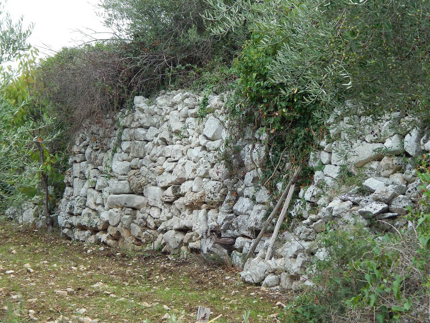
The defensive circuit runs for about 3,450 m around an area of approximately 6 hectares. Its walls have two masonry faces with a central rubble core. Large basal blocks, fitted together without mortar in polygonal masonry, support courses of progressively smaller stones. Depending on preservation, the walls stand 4–6 m high and reach about 5 m thick in some places. The circuit is traceable, and substantial stretches survive in their original positions.
Square structures project from the perimeter, which probably also had watchtowers. Some towers remain on the northern slope, including the steeply situated Torre Belvedere. The northern defenses are particularly massive and include an additional parallel outer wall on the Adriatic-facing side, where the settlement was more exposed. The southern wall is less substantial, facing the protection of the Lama di Mosca ravine. Dry-stone walls follow the line of the circuit, and ancient blocks have been reused in local trulli, traditional Apulian dry-stone buildings, and sheds. The circuit remains visible around the hill.
Southern entrance viaduct
A viaduct once crossed the deep ravine at the southern entrance. It is locally known as the Roman Bridge, although that name does not establish when it was built. The structure is now collapsed.
Burials and civic features
Graves
Classical-period burials include pit graves, semi-chamber tombs with partly enclosed burial chambers, and stone-cist tombs, which use stone-lined burial spaces. Most had been plundered by the time they were found. Eight pit graves excavated in the northern sector date from the late 4th to early 3rd century BC; a separate tomb dates to the 4th century BC.
Acropolis and public evidence
The acropolis, the elevated area of an ancient settlement, was probably at the top of the plateau. Fluted column drums found fallen there have prompted the proposal that a public building stood nearby. Civic bronze coins bear the community’s name in Greek characters. An inscribed architectural piece in the Apulian alphabet, a script used in ancient Apulia, has also been linked to a public building.
Cistern
A flask-shaped cistern identified in the late 1970s is broadly dated to the imperial period. Pottery and three coins found inside it support that dating.
Excavated buildings
Residential and productive complex
One complex excavated in the southeast of the hill dates from the 3rd to the 1st century BC. It appears to combine a residential area with a productive sector, an arrangement characteristic of a rural estate. The residential buildings used limestone and tuff, rock formed from consolidated volcanic ash, and had plaster frescoes and projecting stucco cornices. Floors included compacted earth, crushed stone, and ceramic fragments; others were made with tiles set on edge and covered with mortar.
The less carefully built productive area contained a cistern and large buried storage vessels. A semi-chamber tomb beneath the buildings held pottery and a silver coin, finds that helped establish the complex’s date.
Southern building
A second building farther south was also constructed of limestone and tuff blocks and had decorated plaster and stucco cornices. Dating broadly to the 3rd–2nd centuries BC, it was built over earlier structures, including a large basin. Three bronze asses, Roman coins, were found there.
Cultivation continues across the area and brings decorated pottery fragments, handles, and other pieces of everyday ceramic vessels to the surface.