Obertagstein Castle: A Medieval Hill Castle in Switzerland


Site at a Glance
- Rating
- 4.9
- Popularity
- Very Low
- Country
- Switzerland
- Primary era
- Medieval
- External website
- Open
- Eras represented
- Medieval
- Civilizations
- Holy Roman Empire
- Site type
- Military
- Remains
- Castle
On this page11 sections
History
Obertagstein Castle is a ruined medieval hill castle in Switzerland, above Thusis in the canton of Graubünden. It was probably built around 1300 by the Masein or Rialt family, near Untertagstein Castle, during the late thirteenth century. Its strong defensive construction combined with residential and domestic facilities reflects a period when castles served both as fortified residences and as centres of local lordship.
The Rialt and Bärenburg Connections
Obertagstein was associated with the noble owners of Tagstein Castle near Masein. In 1316, Margareta von Rialt left her properties in Tagstein to her nieces. The first recorded reference to a castle in the area dates from 1322, but it probably concerned Untertagstein rather than Obertagstein. This uncertainty has left the early documentary history of Obertagstein incomplete.
The male line of the Rialt family ended in 1322, and its holdings passed to the Bärenburg family. The Bärenburgs were ministeriales, legally unfree members of the medieval military and administrative elite who served a higher-ranking noble family. They had served the Vaz family, but after the Vaz line became extinct in 1337, the Bärenburgs became vassals of the Counts of Toggenburg. The counts then granted the castle to the Tumb family.
The Tagstein Name and Later History
The Tumb family began using the name von Tagstein, although this designation probably referred to Untertagstein. References to Untertagstein in 1385 and 1387 help establish a relationship between the two Tagstein sites, but they do not resolve which records belong specifically to Obertagstein. The castle’s inhabitants remain unknown, and no noble family actually called Tagstein is known. Hereditary noble names had already become established by the time the castle was built.
A fire destroyed Obertagstein during the late medieval period. The castle was then abandoned, and by 1512 its ruins were listed among the possessions of Cazis Priory, a religious house in Cazis. Red-ochre inscriptions made in the plaster of the window reveals show that people still visited the ruins during the sixteenth century.
Preservation and Archaeological Work
Modern preservation began with a fundraising campaign on the television program Grüezi mitenand in 1972. Under Felix Nöthinger, the Burgenverein Graubünden cleared and structurally secured the ruin. Archaeological investigations led by Lukas Högl uncovered material in the debris left by the fire, including evidence of the castle’s kitchen activities. The access route was renewed in 2015, supporting safer visits to the interior.
Remains
Layout and Construction
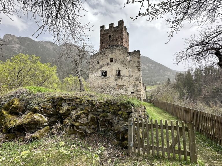
The ruin occupies the summit of a small rock outcrop at about 1,150 metres above sea level, southwest of Thusis on the slope of Piz Beverin. The rock falls steeply on all sides, and the castle complex covers approximately 15 by 15 metres. Roughly laid rubble stone forms most of the walls, while isolated sections use opus spicatum, or herringbone masonry in which stones are set at alternating angles. During construction, the builders left the trunks of two trees standing and incorporated them into the wall. At least two building phases show that occupation continued through an extended period.
Shield Wall and Residential Building
A powerful shield wall protected the uphill side of the castle. The earliest phase occupied only the western corner of the rock and included a five-storey palas, the principal residential building of a medieval castle, attached to the wall. Its ground-level entrance was on the east. A latrine bay projected from the northern side, while a large round smoke outlet survives in the southwest corner. At fifth-floor level, a double round-arched window has surrounds made of tuff, a soft volcanic stone used for architectural details.
On the northern interior side, the palas rose no higher than two storeys, although an additional wooden upper floor may have existed. The original gate stood at the southwest corner and was later blocked. Beam holes beneath it mark the former wooden approach. After a section of the shield wall collapsed beside the cistern, the entrance was moved into the resulting breach. The new gate was probably reached by a wooden bridge and led through the former cistern area into the castle, while the original gate was blocked and fitted with a loophole.
Cistern and Water Collection
The earliest phase also included a cistern set within the shield wall and a natural cleft in the rock. Roof water was collected and carried through wooden channels, then through a small conduit beneath the window sill directly into the reservoir. These arrangements remain clearly visible and explain how the castle stored water on its exposed rocky summit.
Entrances and Defended Passage
From the original southwest gate, a narrow zwinger, or defended passage between fortifications, followed a ledge around the southern side of the rock. It led to a gate on the southeast side and then to the inner entrance. A later route crossed a wooden bridge from the southern outer passage to a lower eastern gate above the sheer drop. From there, a stairway led upward to the palas.
Eastern Enclosure and Kitchen
During the second building phase, construction extended across the entire rock. A wall enclosed the previously open eastern area, and the former northern latrine bay was converted into a projecting bay. A new latrine bay was built farther east in the new wall and remains in use. The second phase also added a kitchen in the southeast. Fire debris from the castle contained grain, nutshells, and kitchen equipment, including rocking knives and copper kettles.
Courtyard and Outer Buildings
The complex included a small courtyard and probably had storage buildings and workshops on the uphill side of the rock. A ditch separated these areas from the castle, and a ring wall above the ditch remains largely standing. Artificial terraces southwest of the castle probably supported further service or agricultural buildings, although their structures do not survive.
Nearby sites