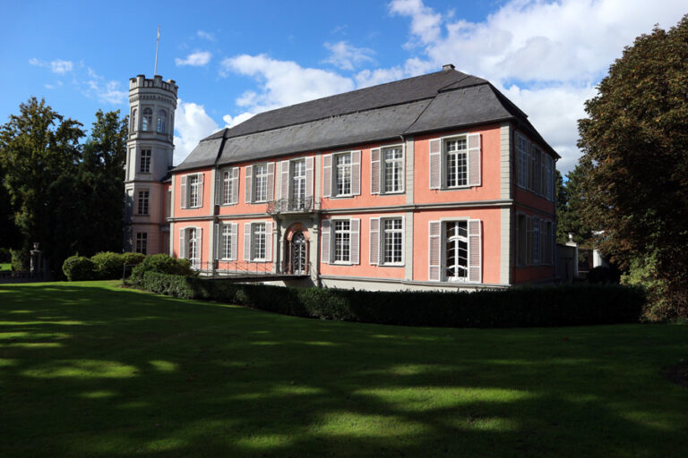
Festung Jülich: Renaissance Citadel and Early-Modern Fortress in Germany


Site at a Glance
- Rating
- 4.4
- Popularity
- Low
- Country
- Germany
- Primary era
- Early Modern
- External website
- Open
- Eras represented
- Medieval, Early Modern, Modern
- Civilizations
- Electorate of Bavaria, French, Holy Roman Empire, Spanish
- Site type
- Military
- Remains
- Citadel
On this page26 sections
History
Festung Jülich is a historic fortress complex in Germany, centred on the town of Jülich and developed in its Renaissance form during the sixteenth century. Built over earlier Roman and medieval defences, it combined a ducal residence with a modern citadel and separate town fortifications. The surviving Renaissance citadel and Napoleonic bridgehead form one of Germany’s most important ensembles of early-modern military architecture.
Roman and Medieval Origins
Jülich began as the Roman vicus of Iuliacum, a settlement that was not normally organized as a full Roman colony or municipium. It stood on the road from Boulogne through Heerlen to Cologne, beside one of the few usable crossings of the Rur. A bridge probably existed here in Roman times, giving the settlement lasting strategic value.
During the fourth century, Iuliacum became a fortified Roman castellum, a military installation enclosed by a defensive circuit probably containing sixteen towers. The fort covered the area around the present market square and was intended to resist incursions from the east. During the Roman withdrawal in the fifth century, it passed into Frankish hands and became the nucleus of the Jülichgau. From this territorial district developed the County of Jülich and, in the fourteenth century, the Duchy of Jülich.
The lords of Jülich probably occupied the western part of the Roman fortification and may have incorporated part of its defensive circuit into their outer wall. A motte, or raised earthwork castle, was built in the present Altenburg district during the twelfth century and destroyed in the thirteenth. Around the turn of the thirteenth and fourteenth centuries, the town received a completely new fortification that enclosed a substantial part of the present old town. Designed for warfare with crossbows, this Gothic system included the Hexenturm and a surviving stretch of town wall between Stiftsherrenstraße and Große Rurstraße.
The Renaissance Reconstruction
By the sixteenth century, the dukes of Jülich had become wealthy and powerful, and Jülich formed part of the United Duchies of Jülich-Cleves-Berg. Duke Wilhelm V sought to extend his rule into Guelders, but Emperor Charles V, the Habsburg ruler, also claimed the succession. Wilhelm’s defeat in the Guelders Feud of 1543 forced him to surrender Guelders under the Treaty of Venlo and to marry a Habsburg woman.
The rapid capture of the duke’s medieval fortresses showed that they could not withstand modern artillery. Wilhelm therefore planned to turn several towns into modern territorial fortresses and, in some cases, princely residences. Düsseldorf was selected for the Duchy of Berg, Orsoy became the principal military stronghold of Cleves, and Jülich was chosen as the residence of the Duchy of Jülich.
Jülich had surrendered to Charles V without a fight and remained undamaged, although construction of a new rondel-based fortification had already begun. Wilhelm commissioned Alessandro Pasqualini, a Bolognese Renaissance architect and fortress builder who had worked extensively in the Netherlands, to oversee the expansion of the three major territorial fortresses and residence cities. Most of Jülich burned during the night of 25 to 26 May 1547. The area around the Hexenturm and present-day Kleine Rurstraße escaped the fire. Although some contemporaries suspected arson, the destruction allowed the town to be rebuilt according to Pasqualini’s ideal-city principles.
Pasqualini’s plan separated the fortress into a citadel containing the ducal residence and a distinct fortification around the town. The citadel was conceived as a palazzo in fortezza, a Renaissance arrangement that joined a princely palace to a military stronghold. The town was laid out as an elongated pentagon, with broad straight streets directed towards the citadel. A strict building code required stone construction and regulated street widths so that the debris from a collapsed house would block only half a roadway, leaving the other half open for movement and helping to limit the effects of fire and street fighting.
The projected citadel was to contain four bastions, each a projecting fortification designed to provide flanking fire along adjoining walls, and was planned at roughly 500 metres from bastion tip to bastion tip. A double defensive circuit would have enclosed the ducal palace, but the citadel ultimately built was about half the intended size. The completed fortress was regarded around 1580 as one of the most powerful and modern fortresses in Europe. Its citadel and town defences remained broadly stable until the end of the fortress period, although both were repeatedly enlarged and modernized with outer works and raised artillery platforms.
The Sieges of 1610 and 1621–1622
During the Jülich-Cleves succession dispute, imperial troops occupied the fortress in 1610. Emperor Rudolf II claimed that the duchy had reverted to the Empire after the ruling line became extinct, while Brandenburg-Prussia and Palatinate-Neuburg also asserted inheritance rights. Their competing claims led to war.
Dutch troops allied with Brandenburg and Palatinate-Neuburg, supported by forces from England, France, and the Protestant Union, began the siege on 28 July 1610 under Moritz of Orange-Nassau and Christian of Anhalt. The besieging army reportedly comprised 18,000 infantry, 3,000 cavalry, and 48 guns, while the garrison numbered about 2,500. Entrenchments isolated the fortress, and the besiegers took position on the Merscher Höhe northeast of the citadel, where the high ground offered a firing position over the works. Larger camps stood at Barmen, Broich, Stetternich, and Bourheim, with French auxiliaries quartered at Koslar.
Approach trenches advanced during the night of 31 July to 1 August. Batteries opened fire on 4, 9, and 14 August. Ravelin II and the counterguards, protective works placed before bastions, fell in succession, allowing breaching batteries to be established before Citadel Bastion II. Shortages of money and food weakened the defenders because the commandant and Jülich official Johann von Reuschenberg zu Overbach had not assembled sufficient supplies. After the imperial commissioner Archduke Leopold left the fortress, his silver tableware was cut into small stamped pieces and issued as emergency money.
The besiegers crossed the partly filled ditch on 26 August, but the defenders rejected an initial demand for surrender. Miners then undermined Citadel Bastion II. By 31 August, their work and 200 artillery shots had opened a wide breach. The garrison surrendered on 1 September 1610, and the surviving defenders received permission to withdraw with honour.
After the siege, the garrison was divided equally between Brandenburg and Palatine-Neuburg troops. When the two victorious princes began disputing in 1614, the Dutch placed Jülich under their protection and appointed Frederik Pithan, a sergeant-major of the Dutch Nassau regiment, as commandant. The new authorities added outer works, especially earthen hornworks, concentrating on the vulnerable northern side of the citadel. The Treaty of Xanten assigned Jülich and Berg to Palatinate-Neuburg, while Cleves, Mark, and Ravensberg went to Brandenburg. The Dutch garrison nevertheless remained in Jülich.
Jülich was besieged again in 1621 and 1622 during the renewed Dutch-Spanish conflict and the opening of the Thirty Years’ War, a wider European conflict that began in 1618 and combined religious and dynastic struggles. Spain intended to use Jülich and Cleves as bases for an invasion of the Netherlands. Ambrosio Spinola commanded the Spanish forces. Count Heinrich von dem Bergh led 7,000 infantry and 700 cavalry against Jülich, and Ernst of Isenburg-Grenzau later arrived with another 4,000 men and eight guns.
The Spanish established their camp at Galgenberg near Broich on 5 September 1621 and again surrounded the fortress with entrenchments. Their main attacks came from the Merscher Höhe. The Dutch had withdrawn 1,000 soldiers before hostilities, leaving about 2,500 defenders under the seventy-two-year-old Pithan. The garrison strengthened its positions before the citadel and repeatedly made sorties. Spinola personally demanded surrender on 24 September, but Pithan refused. On 5 October, a sortie reached the Spanish camp during a fire that reportedly caused considerable damage.
Supplies became scarce because provisions from surrounding magazines had not been brought inside in time. The defenders issued emergency money, while disease spread through the town. Hopes of relief ended when Spinola blocked the Dutch army near Cleves. After the Dutch entered winter quarters, Spinola brought his full force before Jülich and intensified the bombardment from a raised artillery platform known as a cavalier.
Pithan opened negotiations on 17 January 1622, on the condition that no relief or provisions arrived within twelve days. Jülich surrendered to Spain on 3 February. Pithan and 2,000 soldiers were granted an honourable withdrawal, although he was later dismissed from his regiment because his superiors believed that the fortress had not been defended to the utmost.
Spanish, Palatine, and French Control
Spain occupied Jülich for the rest of the Thirty Years’ War and altered and extended its defences. Around 1648, Spanish forces probably moved the Aachen Gate from the extension of the Hexenturm to its present position. Spain left Jülich in 1660, when the fortress was restored to the Palatinate.
French troops blockaded Jülich during the Franco-Dutch War in 1678 but made no serious attack. From 1693, Palatine and later Bavarian authorities substantially enlarged the fortress. They strengthened the citadel with cavaliers, ravelins, counterguards, and a glacis, a gently sloping outer earthwork that exposed attackers to defensive fire. The town received similar but weaker outer defences.
French troops occupied Jülich with the duke’s permission around 1741 and again from 1756 to 1762 during the Seven Years’ War, a major European conflict involving Austria, Prussia, France, Russia, and other powers. They returned without permission from 1772 to 1778. The fortress declined during the late eighteenth century and surrendered without a fight on 3 October 1794, after French forces advanced following the Second Battle of Aldenhoven.
Napoleonic Expansion and the 1814 Blockade
After the Rhine frontier was established, Jülich, then called Juliers, became a French mairie in the Department of the Roer and gained renewed importance as a staging fortress on the military road between the Rhine and France. The French first built the Sternschanze on the Merscher Höhe, an earthen redoubt open at the rear and intended to control the high ground and prevent an enemy from establishing a position there.
Napoleon Bonaparte’s plans aimed to turn Jülich into a major operational base for a field army. They envisaged a greatly enlarged defensive area, military camps, retreats, and a ring of field fortifications. Much of this scheme remained incomplete, although work continued on smaller improvements. A powder magazine in Citadel Bastion St. Johannes was completed in 1811, while a smaller magazine at the bridgehead had been begun in 1806.
The French began constructing a large bridgehead protecting the southwestern front and the Rur crossing in 1799. A new Rur bridge, begun in 1806, was designed as a sluice bridge, with mechanisms that could regulate or impound the river and flood the ground south of the town. Three major forts on the Merscher Höhe were begun in 1804, and Napoleon personally laid their foundation stone. Work stopped after Wesel came under French control in 1806 and Jülich lost priority, despite substantial funds reaching the project. The forts remained at the level of excavated ditches and foundations, while additional forward lunettes, detached field fortifications, were built.
After Napoleon’s defeat at Leipzig in 1813, French forces withdrew behind the Rhine. Allied Prussian, Danish, Mecklenburg, and Swedish troops blockaded Jülich during the winter of 1814. The fortress did not surrender at once, and the besiegers bypassed it by building another bridge across the Rur several kilometres south of the town. Brigadier General St. Loup, the French commandant, rejected a surrender offer in March because supplies were adequate. The defenders capitulated on 28 April, and French troops withdrew on 4 May.
Prussian Fortress and Demolition
The peace settlement of 1814 transferred Jülich to Prussia. Prussia completed the French works apart from the unfinished forts on the Merscher Höhe and established seven forward lunettes, designated A to G, around the town. Five covered the citadel from different directions, while two protected the town from the south. The Neue Flesche was added between Lunettes C and D on the eastern flank.
The fortress was placed on alert in 1831, probably in response to the revolution in France and the Belgian struggle for independence. The order to disarm it followed in 1833, after which only maintenance work continued. New developments in metallurgy, manufacturing, rifled firearms, and accurate breech-loading artillery made older small fortresses increasingly vulnerable. The Prussian cabinet decided in 1859 to abolish the fortress. Local citizens petitioned King Wilhelm to preserve it, or at least the garrison, because many depended economically on fortress maintenance and military contracts.
Jülich remained a garrison town, and a preparatory school for non-commissioned officers was established in the citadel. This use helped preserve the citadel. From 8 to 29 September 1860, the Prussian high command conducted a large siege exercise using the latest Krupp rifled breech-loading guns with explosive shells and the Dreyse needle gun. The exercise demonstrated the advantage of modern weapons and created the Große Bresche, or Great Breach, in the northern face of Bastion Marianne.
Most of the fortifications around Jülich were systematically demolished between 1859 and 1861. The citadel and bridgehead were spared, while the town fortification and outer works were largely destroyed. Both surviving complexes later suffered severe damage during the Second World War and were adapted to new uses. Archaeological investigation, reconstruction, and preservation have maintained the remaining fabric and continued the historical interpretation of the fortress.
Remains
Citadel and Town Plan
The surviving fortress preserves two distinct systems, the citadel with the ducal residence and the separate town fortification. The citadel’s four bastions were Wilhelmus, or Citadel Bastion I; Marianne, or Maria Anna, also Citadel Bastion II; St. Salvator, also Citadel Bastion III; and St. Johannes, also Citadel Bastion IV. The town fortification had four corresponding bastions, St. Sebastianus, St. Eleonore, St. Jakob, and St. Franziskus, whose remains survive in fragmentary form.
The walls and bastions were built from earth faced with brick revetment walls. On the field side, these walls reached as much as five metres in thickness. Barrel-vaulted structures divided the earth inside the main rampart into smaller sections, limiting the flow of material after a breach and delaying the formation of an assault route. The citadel walls rose approximately twelve to fifteen metres, while the town walls reached about eight to ten metres. The citadel ramparts were as much as forty-two metres thick, compared with a maximum of twenty metres for the town rampart.
The lower sections of the walls were battered outward to strengthen them and deflect projectiles thrown from above towards an attacker. Bombproof casemates inside the bastions connected with gun courts in the recessed flanks. The citadel also contained communication passages behind the forward revetment and, in some areas, behind the courtyard wall. Some of these passages were added during later modifications.
Citadel Features
Bastion Marianne and the Große Bresche
Citadel Bastion Marianne, also known as Maria Anna or Citadel Bastion II, retains the Große Bresche in its northern face. The breach was created during the Prussian siege exercise of September 1860, when rifled artillery and explosive shells tested the defensive strength of the older fortress. Its surviving damage is therefore directly associated with the transition from early-modern fortification to nineteenth-century artillery warfare.
Bastion St. Johannes
Bastion St. Johannes, or Citadel Bastion IV, contained a powder magazine completed in 1811 during the French period. The magazine formed part of the fortress’s later military infrastructure and remains associated with the citadel’s Napoleonic modernization.
Gates and Town Defences
Kölntor and Aachen Gate
The Kölntor formed the eastern entrance from the old Roman road towards Cologne. An outer ravelin later protected it. Together with the Aachen Gate, it was one of the most important entrances for through traffic. The Aachen Gate, also called the Rur Gate, formed the southwestern entrance from the bridge over the Rur and was protected by several forward works. Its gate arch and the revetment wall of the adjoining southern curtain survive as far as Town Bastion III, while the adjacent ditch remains beside the present secondary school.
Bongardpforte and Düren Gate
The Bongardpforte cut through the southeastern town rampart and led to the ravelin before that front. It served as a sortie and supply gate rather than as a principal entrance and disappeared around 1633. The Düren Gate stood on the northern side between the citadel and Town Bastion I. It was never especially important and disappeared during the seventeenth century.
Town Bastions
The remains of Town Bastion I, St. Sebastianus, appear as ground undulations near the corner of Schirmerstraße and Bastionsstraße, marking the former ditch. Town Bastion II, St. Eleonore, survives as further ground undulations within the built-up block. Town Bastion III, St. Jakob, lies almost completely underground and includes extensive casemates. Town Bastion IV, St. Franziskus, retains part of its ditch behind the New Town Hall together with several underground vaults.
The Schwanenteich was originally made as a pond for fire-fighting and drinking water. The present promenade follows much of the line of the former town fortification, whose course remains legible in the surviving urban layout. Both connections between the town ditch and the citadel ditch can still be identified. At the western connection, part of the former sluice installation survives in the counterscarp, the outer slope or wall of the ditch, beneath the Bonhoefferhaus.
Ravelins and Counterguards
Ravelin I
Ravelin I, also called Ravelin Lyebeck, stood before the eastern curtain. A ravelin is an outer triangular or detached work positioned before a curtain wall or gate. Significant casemate remains survive beneath a kindergarten, where part of the structure was adapted as an air-raid shelter.
Ravelin II
Ravelin II stood before the northern postern. Sections of its wall and ditch remain on both sides of the access road. During the first siege of 1610, it was a principal focus of the allied attack and fell before the besiegers established their breaching batteries before Citadel Bastion II.
Ravelin III
Ravelin III, also known as Ravelin Judas, stood before the western curtain. It retains substantial earthworks and a sluice installation in the ditch area. Because the earthen work was not built over, it could be restored with relatively little effort.
Ravelin IV
Ravelin IV stood before the town-side postern. Its size remains indicated in the paving, and parts of its gatehouse survive.
Counterguards
Counterguard III before Bastion St. Salvator retains substantial rampart and ditch remains along the northwestern side of the ditch. Counterguard II before Bastion Maria Anna survives as a low earthen bank at the edge of the ditch in front of the bastion point.
Bridgehead and French Works
Rur Bridgehead
The French bridgehead protecting the southwestern front and the Rur crossing was begun in 1799. A bridgehead is a fortified position protecting a bridge or river crossing. The smaller powder magazine at the bridgehead was begun in 1806. The new Rur bridge, also begun in 1806, was designed as a sluice bridge capable of controlling the river and flooding the ground south of Jülich.
Sternschanze and Merscher Höhe Forts
The Sternschanze on the Merscher Höhe was an earthen redoubt intended to control the high ground and prevent an attacker from occupying it. It was probably built soon after the French took Jülich, later levelled to make way for projected forts, and rediscovered near the relocated settlement of Lich-Steinstraß during excavation for a housing development at the end of the twentieth century.
Three projected forts on the Merscher Höhe were begun in 1804 but remained at the stage of excavated ditches and foundations. Their traces were visible into the second half of the twentieth century and appeared in plans and aerial photographs. Later, a cemetery extension and construction of the Fachhochschule destroyed these remains. Minor remnants survive on post-office property near the shortwave-centre transmitter.
Prussian Lunettes and Surviving Traces
French forward lunettes were first built east, south, and west of the fortress and were later designated D to G. After the Merscher Höhe forts stalled, Lunettes A to C were added. Prussia retained and completed the seven-lunette system, with five works covering the citadel and two protecting the town from the south. The Neue Flesche covered the interval between Lunettes C and D.
The former positions of Lunettes A, B, and C can still be traced along Artilleriestraße. Wilhelmstraße follows the former covered way, a protected route along the outer edge of a ditch, from the Kölntor towards Lünette D. The plot of Lünette F remains identifiable in the cadastre, and its former access road is now called An der Lünette. Some earthworks of Lünette A also survive. The site of Lünette C is occupied by the guesthouse of the research centre, while the Kolfs Insel housing development occupies the site of Lünette F.
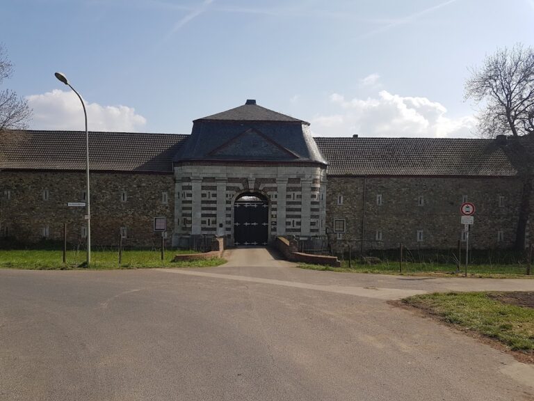
Although the town fortification was largely dismantled in the nineteenth century and later damaged, its surviving walls, ditches, underground casemates, earthworks, gates, and traces in the modern town preserve the outline of the system. The citadel and bridgehead remain the principal surviving complexes, carrying the physical evidence of Jülich’s development from a Roman river crossing and medieval town defence into a Renaissance residence fortress and a Napoleonic military position.