Fortress Ensemble of Mangup: A Byzantine and Feodoran Defensive System in Russia


Site at a Glance
- Rating
- 4.9
- Popularity
- Medium
- Country
- Russia
- Primary era
- Medieval
- Eras represented
- Medieval, Early Modern
- Civilizations
- Byzantine, Ottoman
- Site type
- Military
- Remains
- Wall
On this page10 sections
History
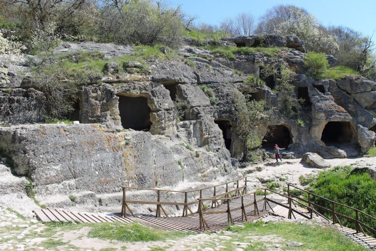
The fortress ensemble of Mangup is a large fortified refuge in Russia, built and developed on the Baba-Dag mountain plateau by Byzantine and later medieval powers. Covering about 90 hectares, it enclosed the city and its garrison while also providing shelter for additional troops, people from the surrounding valleys, livestock, and property. Its defenses combined massive walls with cliffs reaching up to 70 metres high, making the plateau difficult to approach.
Byzantine foundation
The earliest major fortification was the Main Line of Defense, constructed in the second half of the sixth century during the reign of Justinian I, the Byzantine emperor who ruled from AD 527 to 565 and sponsored extensive building and defensive works. The work was initiated by the administration of the Byzantine theme of Chersonesos, a provincial military and administrative district, and carried out under Byzantine engineers. A fragment of an inscription found in 1913 mentions Emperor Justinian, placing the construction no earlier than AD 562-563.
The Main Line blocked the accessible approaches to the plateau while the cliffs protected most of its perimeter. It remained nearly in its original form until the beginning of the sixteenth century, although damaged sections were repaired after warfare or natural forces. A later commemorative inscription, dating from the fourteenth century, may refer to rebuilding directed by Khuitan, a commander of a hundred. The wall in the Tabana-dere ravine was rebuilt in AD 994-995, when Mangup still belonged to the Byzantine theme of Chersonesos.
Khazar control and later medieval development
After the Khazars, a powerful polity of the Eurasian steppe, captured Mangup in the 780s, their authorities controlled the fortress for approximately sixty years. They rebuilt parts of the defensive system. In the Tabana-dere ravine, the early Byzantine wall was moved about 100 metres higher up the slope, using blocks taken from the earlier structure.
The mature arrangement of the fortress probably took shape no earlier than the fourteenth or fifteenth century, when Mangup became the capital of the Principality of Feodoro. This system comprised the Main Line of Defense, the Second or Inner Line of Defense, and the citadel on the Teshkli-Burun promontory. The city was destroyed in the 1390s. During its restoration under Prince Alexei in the early fifteenth century, the Second Line was built as an additional defensive position behind the principal fortifications.
Ottoman reconstruction and continued use
Following the Ottoman capture of Mangup around 1500, the Main Line was substantially adapted for firearms. Sections of the enceinte, or enclosing defensive wall, were moved higher up the slope, curtain walls were straightened, older towers were rebuilt, and new towers were added. These changes altered parts of the earlier defensive arrangement while preserving its basic role in controlling the approaches to the plateau.
The citadel continued to serve different purposes until the second half of the eighteenth century. It had also functioned as the princely palace of the rulers of Feodoro, giving the fortified promontory both a military and political role.
Remains
Main Line of Defense
Walls and fortified approaches
The Main Line consists of separate wall sections that close the upper ends of ravines and fissures leading toward the plateau, especially at the Chamnu-Burun and Chufut-Cheargan-Burun promontories. Walls and fighting parapets also blocked passages beside the southern cliffs. Several possible ascents on this side were fortified, including a principal stepped slope about 100 metres wide, two narrow ravines with paths, and several steep but passable fissures. Rock projections that might have allowed attackers to bypass the defenses were cut back, while short walls closed the fissures.
The walls used a double-shell construction up to 1.8 metres thick. Their outer faces were formed from regular courses of closely fitted stone blocks, some measuring approximately 0.92 by 0.65 metres and others about 0.29 by 0.45 metres. The core consisted of medium-sized broken stone set in lime mortar. Rectangular defensive towers stood on the longest sections crossing the ravines. In constructional terms, this was the earliest and most complex of the fortress ensemble’s three defensive elements.
The principal gate
Three approaches to the fortress have been identified. The route suitable for wheeled transport ran from the Almalyk-dere ravine beneath the cliffs of Teshkli-Burun to the main gate in the upper part of the Kapu-dere ravine. Its final stretch crossed an artificial embankment reinforced with large stones set vertically, probably built at the same time as the fortifications.
The principal gate was the fortress’s only gate, consistent with early Byzantine fortification practice. Carefully dressed and fitted stone blocks formed the entrance, which had a barrel vault supported on one side by a pier and on the other by the rocky base of Teshkli-Burun. The arch spanned 3.8 metres, and the passage was about 2.6 metres wide. By 1821, the vault had collapsed. The remaining gate pier, made from dressed stone, is regarded as an expressive example of monumental masonry from Mangup’s Justinianic period, meaning the architectural and military practices associated with Justinian’s reign.
The two other routes passed through the Gamam-dere and Tabana-dere ravines. They were steeper and probably unsuitable for wheeled vehicles, though they could have carried pack animals. Openings through the walls may have existed, while the small surviving gates belong to the Ottoman period.
Second or Inner Line of Defense
The Second Line is an almost straight wall about 620 metres long. It runs from the base of the Elli-Burun promontory toward the southern cliffs in a southwesterly direction, separating the uninhabited part of the plateau from the city. Its nine towers had open rear sides and reached up to 8 metres in height. The wall was no more than 1 metre thick and included crenellations and loopholes.
The line lacked a ditch and an advanced forework, indicating that it supplemented rather than replaced the Main Line. Tower spacing followed the perceived likelihood of attack, with intervals of about 46 metres allowing fire to cover the ground between them. The northeastern flank, which crossed the upper Tabana-dere ravine, extends for about 350 metres and contains six towers. The southwestern section has three towers, with intervals of 95 and 118 metres, an irregular arrangement attributed to the terrain.
Citadel on Teshkli-Burun
The citadel occupies the Teshkli-Burun promontory. A wall encloses the tip of the promontory, while a tower-donjon, a major fortified tower used as a stronghold or ruler’s residence, forms its principal structure. Built in the fourteenth century, the donjon also served as the princely palace of the rulers of Feodoro. The citadel therefore combined the defensive function of a strongpoint with the residential and political functions of the principality’s ruling household.