Aspendos: An Ancient City-State and Roman Monumental Centre in Türkiye



Site at a Glance
- Rating
- 4.8
- Popularity
- High
- Country
- Turkey
- Primary era
- Classical
- Eras represented
- Iron Age, Classical, Medieval
- Civilizations
- Ancient Greek, Byzantine, Roman, Seljuk
- Site type
- City
On this page17 sections
History
Aspendos was an ancient city-state of Pamphylia in present-day Türkiye, near the modern settlement of Belkıs and the Eurymedon River. Inhabited from the Early Iron Age, it developed into a prosperous regional centre whose best-preserved monuments belong mainly to the Roman period, especially the second and third centuries AD. The city remained occupied through the Byzantine and Seljuq periods before being abandoned in the eighteenth century.
Early settlement and Pamphylian identity
Aspendos stood in Pamphylia, an ancient region corresponding broadly to part of southern Anatolia. Its origins are uncertain. A later tradition placed its foundation around 1000 BC and attributed it to Greeks from Argos, while other traditions associated the city with an eponymous hero or with settlers linked to Mopsus, a legendary seer and hero of early Greek settlement traditions in Anatolia. The population included Greeks and Pamphylians, and many names preserved on funerary stelae were Anatolian. Some scholars connect the name Aspendos with Azatiwada, the ruler associated with the founding of the city at modern Karatepe in Cilicia.
By the fifth century BC, Aspendos had become one of the most important cities in Pamphylia. Its position beside the navigable Eurymedon supported river trade and linked the city with the Mediterranean coast. Salt, olive oil, wool, wine, cereals, fruit, horses, agricultural production, and nearby forests contributed to its wealth. Its economic strength exceeded its political influence, and relations with the neighbouring coastal city of Side were hostile.
Persian rule and the Battle of the Eurymedon
After a period under Lycian hegemony, Aspendos came under Persian rule in the mid-sixth century BC. The Achaemenid Empire, the Persian imperial dynasty that controlled much of the Near East and Anatolia before Alexander’s conquests, allowed the city a substantial degree of autonomy. Aspendos continued to issue coins in its own name and supplied the empire with horses and soldiers.
Around 465 BC, Cimon, an Athenian statesman and military commander, defeated a Persian fleet and army in the Battle of the Eurymedon near the river mouth. Aspendos subsequently became associated with the Delian League, the alliance of Greek states led by Athens and originally organized against Persia. Its alleged appearance in the league’s tribute lists remains uncertain.
In 411 BC, the Persians regained control of Aspendos and used the city as a military base. Around 388 or 389 BC, the Athenian commander Thrasybulus demanded payment from the inhabitants. They collected money to persuade him to withdraw without damaging the surrounding countryside. After accepting the payment, however, he allowed his men to trample the crops. The enraged Aspendians killed Thrasybulus in his tent.
Macedonian conquest and Hellenistic rule
Alexander the Great reached Aspendos in 333 BC after capturing Perge. The inhabitants first negotiated to avoid a Macedonian garrison, offering taxes and the horses that had previously been supplied to the Persian king. They later refused to ratify the agreement and prepared to resist. Alexander returned and besieged the city, forcing its inhabitants to withdraw to the acropolis and surrender under harsher terms. A Macedonian garrison remained, and Aspendos paid an annual tribute of 100 talents and 4,000 horses.
After Alexander’s death in 323 BC, Aspendos passed at different times under Seleucid and Ptolemaic control before becoming part of the Kingdom of Pergamon. Around 190 or 189 BC, the city surrendered to the Romans. During the Roman Republic, administration was largely directed towards extracting money and artistic treasures. The Roman magistrate Gaius Verres was later accused by Cicero of plundering artworks from the city.
Roman prosperity
Aspendos prospered particularly during the second and third centuries AD. Its river port, agricultural lands, forests, salt production, and commercial connections supported exports of salt, wine, textiles, furniture, wooden figurines, and horses for which the city was renowned. Philostratus, a Greek-speaking writer and sophist of the Roman imperial period, ranked Aspendos as the third city of Pamphylia.
Wine production also entered the city’s religious traditions. Although Aspendos produced wine, its inhabitants were said not to use it in religious rites because birds would not dare to eat grapes intended for the gods. Literary evidence records a sanctuary of Artemis under the local epithet Kastnietis. Cults, and probably sanctuaries, also existed for Athena, Zeus, Hera, and probably Hermes.
Aspendos began minting coins around 500 BC. Its mint issued staters at first and later drachms, continuing from the Archaic Greek period into the late Roman period. Early coins used abbreviations derived from the local Pamphylian name Estwedus. Their usual imagery included a slinger on the front and a triskelion on the reverse.
Byzantine and Seljuq occupation
The city declined from the late Roman period onward but remained an important settlement during the Byzantine era. For a time in that period it was known as Primopolis, although the ancient name Aspendos later returned. The city also became a Christian bishopric subordinate to the metropolitan see of Side in the Roman province of Pamphylia Prima.
Bishops associated with Aspendos included Domnus, linked with the First Council of Nicaea in 325; Tribonianus, linked with the Council of Ephesus in 431; Timotheus, associated with a synod of 448 and a later council at Ephesus; and Leo, associated with the Second Council of Nicaea in 787. The former bishopric is now a titular see of the Catholic Church.
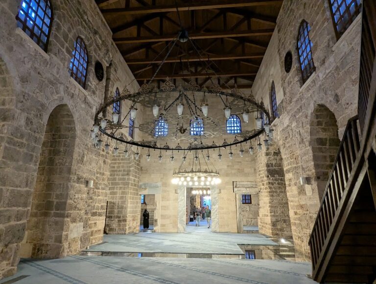
In the twelfth or early thirteenth century, Aspendos came under the Seljuq Sultanate of Rum, a medieval Turkish state centred in Anatolia. During the reign of Kayqubad I, the theatre was repaired and decorated in Seljuq style for use as a palace. The Seljuqs also used it as a caravanserai, a roadside lodging and service complex for travelling merchants and caravans. The city remained occupied into the Seljuq period and was abandoned in the eighteenth century.
The ancient theatre and aqueducts have been on Türkiye’s tentative list for nomination to the UNESCO World Heritage List since 2015.
Remains
Hilltop city and acropolis
Aspendos occupied a high, isolated, flat-topped hill immediately west of the Eurymedon. The hill rises approximately 39 metres and is divided by a depression into a larger western urban hill and a smaller eastern Theatre Hill. The city occupied the urban hill, while the theatre was built on the eastern slope. The acropolis overlooked the surrounding plain and river.
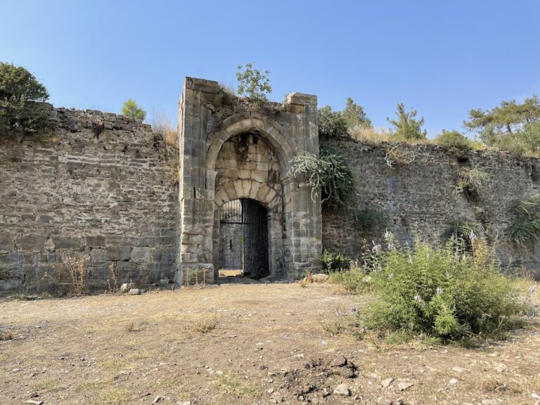
The urban hill was fortified by at least 333 BC. Its sides were mostly steep, while two channels on the eastern side led towards the eastern and southern gates. A third gate stood near the northern end of the hill. The visible remains are dominated by Roman construction, with later alterations reflecting the continued occupation of the site.
Agora and public buildings
The agora occupied the level summit of the acropolis and was bordered on three sides by public buildings. Its surviving surroundings include the basilica, a long market building, a stoa, a structure traditionally identified as a nymphaeum, and a building known as the bouleuterion or ekklesiasterion. A stoa, a roofed colonnade, formerly stood in front of the market building, and its position is marked by a surviving row of steps.
Basilica
The basilica on the eastern side of the agora was approximately 125 metres long. It consisted of a large main hall and an attached building at its northern end. The main hall had a higher roof and was divided from smaller side rooms by columns. The attached structure survives to more than 15 metres in height. It has three doors opening towards the main hall, another door on the north side, two windows in its southern wall, and four external buttresses on its western wall. A court lay inside the basilica. Substantial Byzantine modifications changed the building and removed many of its original features.
Market building
The market building on the western side of the agora was long and two storeys high. Its ground level contained twelve shops of equal size, with a passage behind them. The colonnaded stoa that once stood in front has disappeared, but the steps marking its position preserve the relationship between the market frontage and the open agora.
Monumental fountain building
The building conventionally called the nymphaeum occupies the northern side of the agora. A nymphaeum was a monumental fountain or fountain house, commonly decorated with columns, niches, and sculpture. At Aspendos, the structure survives mainly as a monumental wall approximately 50 metres long, 15 metres high, and 1.8 metres thick.
Its elaborate south-facing facade had two levels, each containing five niches. The central niche on the lower level was larger and may have served as a doorway. Marble bases indicate that columns formed part of the original facade. The interpretation as a nymphaeum is supported by its connection with the aqueduct and its resemblance to fountain buildings elsewhere. The structure has also been understood as a decorative facade for the agora.
Civic building and other acropolis remains
At the northwestern corner of the agora stands a building known as the bouleuterion, although its function remains uncertain. A bouleuterion was normally a meeting place for a city’s council, while an ekklesiasterion was a hall or space for a civic assembly. The building measures approximately 48 by 27 metres and has a rounded eastern end. It may have served as a council house, a covered odeon, or another roofed theatre.
Other remains on the acropolis include an exedra south of the basilica, an arch north of the monumental fountain building, a square northeast of the arch, and a Doric temple farther to the northeast. Parts of the main street survive, together with a well-preserved drainage system and several structures around the agora whose walls still stand to considerable heights.
Roman theatre
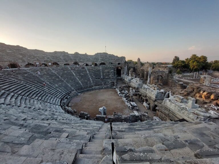
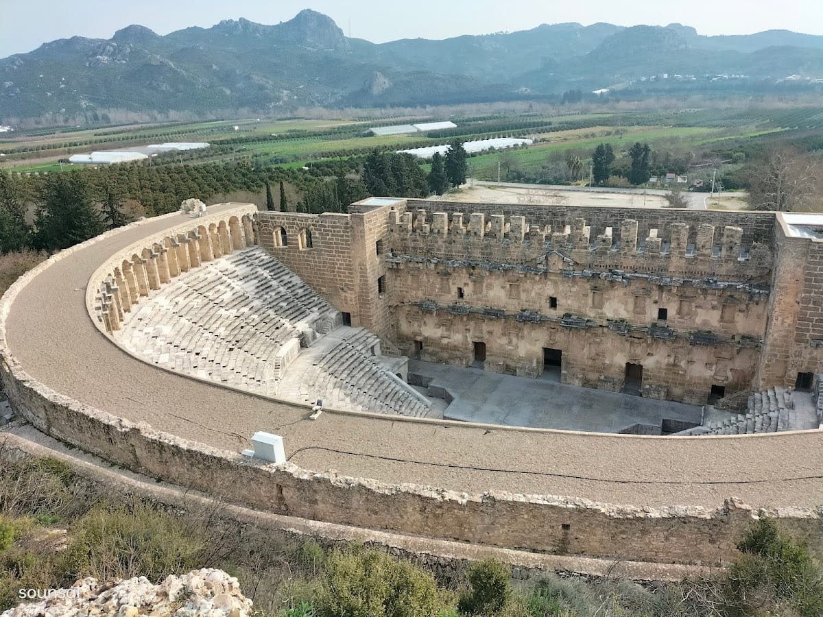
The Roman theatre was built in the second century AD, with proposed dates of 155 or, more broadly, around 160 to 180. It was designed by Zenon, a local Greek architect, and commissioned by Curtius Crispinus and Curtius Auspicatus. The building has a diameter of approximately 96 metres. Estimates of its original capacity range from about 7,000 to 15,000 spectators, while a later event demonstrated that more than 20,000 people could be accommodated.
Following Hellenistic design practice, part of the theatre was built against the hillside and the rest rested on vaulted arches. The cavea, or seating area, opens slightly towards the southeast and contains 41 rows divided by a horizontal diazoma, a passage separating seating levels. Twenty rows lie below the passage and 21 above it. Stairways divide the seats into sections, with ten below the diazoma and 21 above. Some seats carry carved names. An upper open passage bordered by an arched gallery has been repaired several times.
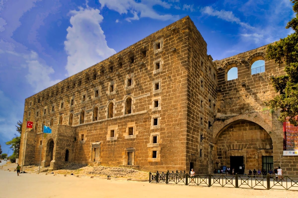
The stage building is approximately 100 metres wide and 22 metres high. Its outer facade has a large central doorway, two smaller side doors, and four rows of windows above them. Five doors in the inner wall open onto the stage. Facing the auditorium, the facade originally carried two rows of columns on each of two levels, with statue niches between them. Column-supported pediments stood above the niches, and a large upper pediment carried a relief of Bacchus, the Roman name for Dionysus, the god associated with wine, festivity, and theatre.
The stage was about 6 metres deep and slightly more than 1.5 metres high. The theatre was built from conglomerate and marble. Its high stage wall and architectural backdrop, or scaenae frons, remain largely intact, while the sloping wooden roof over the stage has disappeared. Fifty-eight post holes survive in the upper levels, marking the supports of a former velarium, a fabric awning stretched above spectators for shade. The orchestra, the central performance area in front of the stage, is approximately 23.9 metres in diameter, and the columned stage backdrop was about 15.7 metres high.
The Seljuqs repaired the theatre several times, used it as a caravanserai, and converted its stage building into a palace in the thirteenth century. The structure continues to host selected opera and ballet performances. A nearby modern arena was built because modern stage equipment had caused damage to the ancient theatre.
Stadium and lower city
The stadium lies north of the theatre on lower, level ground and follows an approximately north to south alignment. Its northern end is rounded, while the southern end is open. A vaulted passage beneath the seating allowed spectators to move through the building. Shops lined the eastern side, and small windows in their rear walls opened onto the passage.
Two buildings in the lower city south of the theatre have been identified as baths. An inscription mentions a hippodrome, although the structure has not been located. It may have been an open area without permanent seating.
Aqueduct and river crossing
The Roman aqueduct brought water from hills and marshland approximately 15 to 19 kilometres north of the city. Tiberius Claudius Italicus donated the construction, and an inscription records an expenditure of two million denarii. The aqueduct crossed a marshy valley on arches that also served as a viaduct.
Its final approximately 850-metre section survives prominently north of the acropolis, while smaller portions remain on the acropolis itself. The bridge piers reached about 30 metres in height. At the top of each pier, water passed from a pipe into an open basin, releasing air and improving the flow.
The system included an approximately 2-kilometre inverted siphon, a pressurized aqueduct section that descended into a valley and rose again to cross lower ground. It was divided into three bridge sections measuring approximately 592, 924, and 154 metres. Two square towers, each about 5.5 metres wide, separated the sections and allowed the water to change direction as it rose and fell.
The central section had 46 arches, of which 29 remain standing, reaching heights of up to 15 metres. Between the towers, the siphon descended about 40 metres, generating approximately 400 kilopascals of pressure and supplying about 5,600 cubic metres of water per day. Its pipes were made from carefully fitted limestone blocks sealed with mortar composed of lime and olive oil.
A Roman bridge crossed the Eurymedon near Aspendos. It was reconstructed in the thirteenth century, preserving another connection between the city and the river that supported its communications and economy.
Religious and funerary remains
The city’s religious landscape included the sanctuary of Artemis Kastnietis and cults, probably accompanied by sanctuaries, dedicated to Athena, Zeus, Hera, and Hermes. These associations belong to the religious life of Aspendos as a Pamphylian city with Greek and Anatolian cultural elements.
The necropolis lay along the road east of the acropolis. It contained several funerary buildings, a rock-cut tomb, and numerous Hellenistic funerary stelae. Many of the stelae have pediments and acroteria, ornaments placed at the apex or corners of a pediment, and their names reflect the Anatolian component of the city’s population.