Bukelon Fortress: A Roman, Byzantine, and Medieval Bulgarian Fortification
Site at a Glance
- Rating
- 4.8
- Popularity
- Low
- Country
- Bulgaria
- Primary era
- Medieval
- External website
- Open
- Eras represented
- Classical, Medieval
- Civilizations
- Byzantine, Roman
- Site type
- Military
- Remains
- Castle
On this page10 sections
History
Bukelon Fortress is a Roman, Byzantine, and medieval Bulgarian fortification near Matochina in southeastern Bulgaria, built in successive defensive phases above the Tundzha River. Its earliest enclosure is associated with ancient Adrianople, while the surviving medieval tower reflects the fortress’s later strategic role near the Byzantine frontier.
Roman and Byzantine phases
The earliest fortification is identified as a Roman castra, a fortified military settlement or stronghold, built to protect the perimeter of Adrianople, known today as Edirne in Turkey. The construction technique and surviving remains indicate that this earlier defence lay beneath the medieval fortress. Many scholars identify the site with Vukelon, a small stronghold mentioned in ancient and medieval sources.
The name appears as “Vukel” in a ninth-century triumphal inscription associated with Khan Krum, the ruler of the First Bulgarian Empire who expanded Bulgarian control into Byzantine territory. A marble inscription records that Krum captured Vukelon in 813 together with several other fortresses. A Byzantine lead seal belonging to Christopher, a frontier governor of Adrianople, dates to approximately 822–823 and is preserved in the National History Museum.
Many researchers have proposed that the Battle of Adrianople in 378 took place near the fortress. This battle formed part of the Gothic War of 376–382, a conflict between the Roman Empire and the Goths. The Roman army suffered a catastrophic defeat, and the emperor Valens was surrounded and killed by the Goths, although the exact battlefield remains uncertain.
Medieval rule and conflict
During negotiations in 1324 between Tsar Michael Shishman and the Byzantine emperors Andronikos II and Andronikos III, Vukelon remained under Byzantine control. In 1328 its garrison surrendered the fortress to Michael Shishman, who established a camp there for about a month while preparing for a possible battle. After negotiations, he returned the fortress to Byzantium, reportedly under threat of attack and, according to one account, in exchange for a large ransom.
In 1344, during a Byzantine civil conflict, Manuel Apokaukos left Adrianople and occupied Vukelon after joining the faction of John VI Kantakouzenos. The medieval donjon, the principal fortified tower of a castle with defensive and residential functions, was probably built between the twelfth and fourteenth centuries, although its exact date is uncertain.
Ottoman period and modern investigation
Under Ottoman rule, the fortress lost its importance and became deserted, while the surrounding area grew heavily forested. Sultan Mehmed IV hunted at the foot of the fortress and near the settlement in 1664. The settlement below the hill was destroyed in 1829 during the Russo-Turkish War. A contemporary description then recorded the fortress tower and the ruins of an old castle on the hill.
The first comprehensive architectural and archaeological investigation took place in 1961 under Stefan Boyadzhiev, with its results published in 1965. The ruins were declared an object of national importance in 1968, and limited conservation of the medieval tower followed in 1970. Further conservation was carried out in 2008 using an updated version of a 1982 project. Archaeological excavations began in 2017 under the National History Museum and archaeologist Mariela Inkova, confirming an earlier wall around the hill and revealing several phases of occupation and destruction. Bukelon Fortress is a state-owned cultural monument of national importance.
Remains
Hilltop setting and enclosure
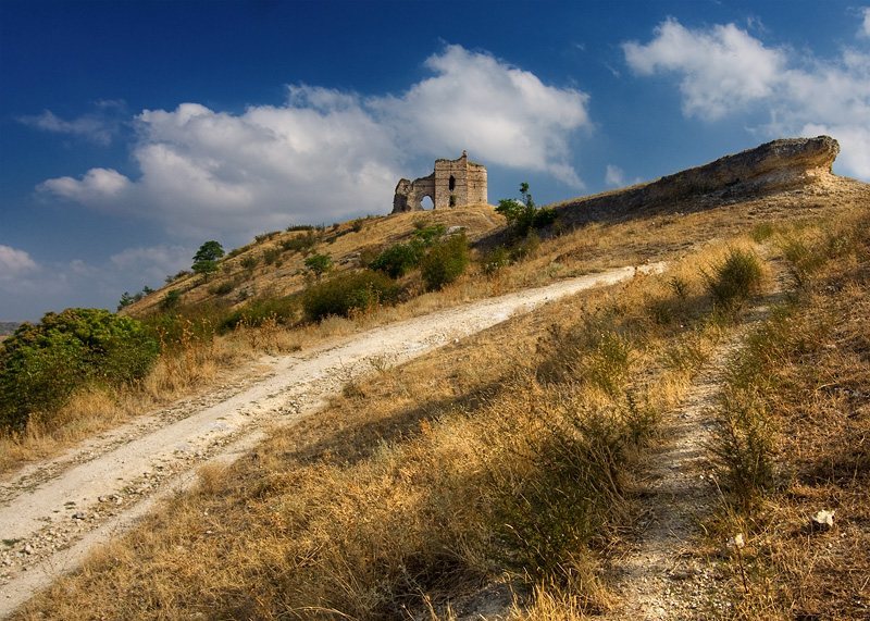
The fortress occupies a relatively small, fairly level plateau on a hill above the lowlands of the Tundzha River. Steep slopes make the hill difficult to approach, while the southern side provides the principal access from Matochina and leads to the only cart road. The plateau measures approximately 65 metres across and 150 metres in length.
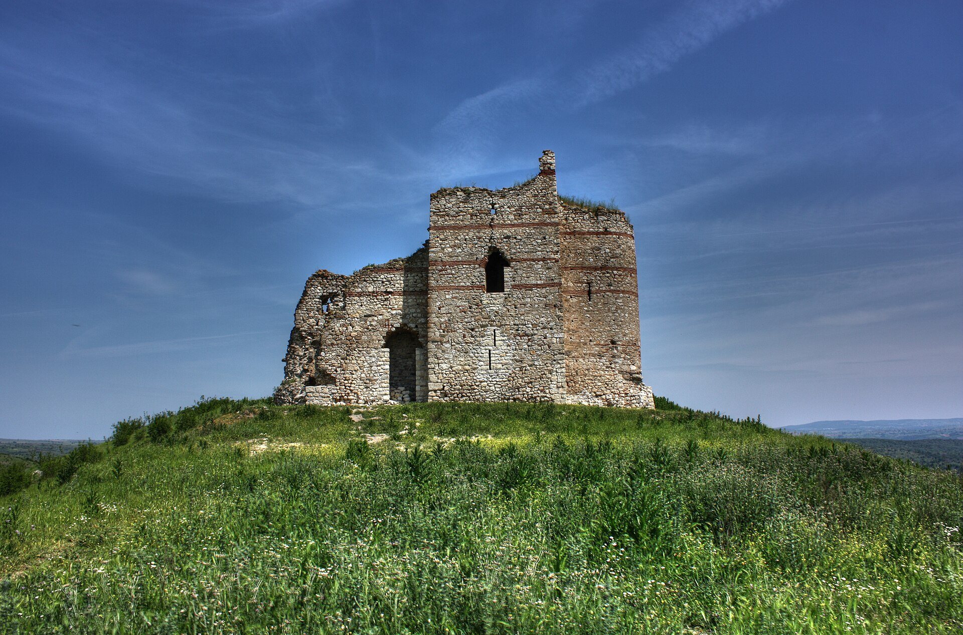
An earlier defensive wall encircles the plateau. It was built in opus mixtum, a Roman masonry technique combining stone and brick, and is associated with the ancient defensive system of Adrianople. The medieval tower was later constructed over part of this enclosure, which survived to approximately 1.80 metres in height when the tower was built.
Medieval donjon
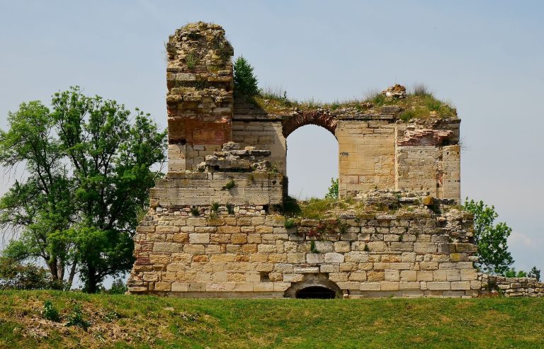
The surviving tower stands at the southern end of the hill, guarding the approach to the plateau and the cart road. Its masonry rises approximately 18 metres and forms the fortress’s prominent donjon. The structure is made from crushed stone bonded with plaster, while fired bricks decorate its facades.
The tower has an eastern semicylindrical section, a rectangular central body that contained accommodation, and a western corridor positioned over the earlier castle wall. A cross-shaped monogram with the letters M, N, L, and K appears at the entrance. Conservation carried out in 1970 and 2008 helped preserve the surviving medieval masonry.
Archaeological evidence
Structures and excavated finds
Little of the fortress’s other construction survives, but archaeological and surface evidence includes a water container or reservoir, possible cult places, spherical depressions cut into the rock, and traces of a small chapel. Excavations in 2017 exposed a fortification wall approximately 2 metres thick and several service or economic rooms. Arrowheads, domestic objects, and clothing ornaments were recovered from the excavated areas.
Seals, coins, and ornaments
The excavations produced a Byzantine lead seal bearing the Virgin Orans, an image of the Virgin Mary with raised hands in prayer, on one side and its owner’s inscription on the other. After restoration and examination, the inscription was read as referring to a protogerakarios, a Byzantine court title meaning chief falconer and tentatively dated to the late thirteenth or early fourteenth century. This is the second Byzantine lead seal associated with the fortress. The other, dating to approximately 822–823, belonged to Christopher, the frontier governor of Adrianople.
A burned coin of the emperor Justin II, who ruled from 565 to 578, provides evidence that the fortress was burned during the second half of the sixth century. Two tenth-century Old Bulgarian heart-shaped appliques indicate Bulgarian presence in the fortress area. From the tower and hilltop, the surrounding landscape extends toward the Sakar and Strandzha mountains, the Tundzha valley, the Turkish border, and the plain around Adrianople.