Castle of Loulé: An Islamic Fortification and Medieval Castle in Portugal

Site at a Glance
- Rating
- 4.3
- Popularity
- Medium
- Country
- Portugal
- Primary era
- Medieval
- External website
- Open
- Eras represented
- Medieval
- Civilizations
- Almohad, Portuguese
- Site type
- Military
- Remains
- Wall
On this page17 sections
History
Castle of Loulé is a fortified historic complex in Loulé, Portugal, whose earliest major development as an urban and military center took place under Islamic rule before the Christian conquest of the Algarve. The site preserves evidence of Roman occupation, Islamic fortifications, the medieval Christian castle, and later changes that absorbed much of the defensive circuit into the town.
Before and during Islamic rule
A settlement existed at Loulé before the arrival of Islamic forces. Roman troops occupied the site around the 2nd century BC, when it became a military, political, and administrative center. A fortified settlement known as a castro, a stronghold usually associated with pre-Roman communities of western Iberia, may have preceded the Roman presence. A votive altar is among the Roman remains, while other discoveries may belong to the Protohistoric period, the transition between prehistory and written history. The settlement has also been attributed to prehistoric, Carthaginian, and Roman origins, but these interpretations remain unresolved.
Islamic forces occupied Loulé in 715. During the Islamic period, the town was known as al-Ulya or Aloalia and became a prosperous regional administrative center. Shortly before the Christian reconquest, it belonged to the Taifa of Niebla under Ibn Mahfuz. Its fortified urban area was divided into an alcazaba, a citadel or military quarter, and a medina, the main urban settlement containing civilian and administrative functions.
The Almohads, a North African Islamic dynasty that ruled parts of North Africa and the Iberian Peninsula during the 12th and early 13th centuries, constructed the town’s rammed-earth defenses. The fortified settlement covered approximately five hectares. Archaeological work has found evidence of intensive occupation in the northern part of the former medina from the 10th century onward, together with sections of the Islamic defenses and their rampart walk.
Christian conquest and reconstruction
Loulé was briefly conquered in the 11th century by Ferdinand, King of León, but Christian control did not last. The town was definitively taken in 1249 by Paio Peres Correia, master of the Order of Santiago, a military religious order involved in the Christian conquest and administration of Iberian territories, during Afonso III’s campaign in the Algarve.
About seventeen years after the conquest, Afonso III ordered the reconstruction and enlargement of Loulé. He granted the town a foral, a medieval Portuguese charter defining municipal rights and obligations, in 1266 or 1267. The charter gave Loulé’s inhabitants rights comparable to those granted to residents of Faro, Silves, and Tavira. The rebuilt castle included a keep and a wall circuit with six gates. The scale of the defenses and the number of entrances indicate that the fortified town continued to support a substantial population. A document from 1266 also mentions several churches in Loulé.
The inner castle enclosure, or castelejo, was built after the reconquest. The alcaidaria, the residence or administrative seat of the castle governor, was established on the probable site of the former alcazaba, possibly over earlier Islamic residential structures. In 1280, Denis of Portugal donated Loulé and its domains to the Order of Santiago. In 1291, he established a fifteen-day fair in September, reinforcing the town’s administrative and economic role. Peter I stayed in the castle’s alcaidaria from 9 to 12 April 1359.
Late medieval rebuilding and royal connections
During the crisis of 1383 to 1385, a succession struggle that threatened Portuguese independence and involved Castilian intervention, Loulé was described as seriously depopulated. The castle had been abandoned, buildings were ruined, and the walls were neglected. Concern about a Castilian attack led the municipal council to repair the tower above the Faro Gate and raise the walls and battlements on the southern side of the town. John I later granted privileges intended to encourage residents from the surrounding territory to settle within the fortified enclosure.
Economic growth in the Algarve during Portugal’s period of overseas expansion benefited Loulé. The town exported wine, olive oil, fruit, dried fish, and salt. In 1422 or 1462, Henrique de Meneses, first Count of Loulé, rebuilt the walls and towers after receiving the title and lordship from Afonso V. The lordship later passed to Francisco Coutinho, Count of Marialva, and then to Guiomar Coutinho as her marriage dowry when she married Ferdinand, the son of Manuel I. As she left no descendants, the lordship eventually returned to the Crown before being granted to the Counts of Vale de Reis.
Manuel I issued a new charter for Loulé in 1501 or 1504. Sebastian of Portugal spent the night of 29 January 1573 in the castle’s alcaidaria, continuing the building’s association with the town’s governing and royal history.
Decline, urban transformation, and conservation
A survey of the Algarve’s defenses in 1617 and 1618 found most of Loulé’s rammed-earth walls damaged or ruined. After the Restoration of Portuguese independence, advances in artillery reduced the castle’s military value, while the expanding town increasingly incorporated the fortifications into ordinary urban development.
The earthquake of 1755 destroyed much of Loulé, including towers and substantial sections of the castle walls. During the 19th century, land beside the walls was divided for residential and commercial use. Further sections were demolished or built into later structures. The Vila Gate was destroyed in 1873, together with much of the surrounding walls and the Chapel of Our Lady of Carmo. Another section was demolished in 1907 during construction and urbanization around the Municipal Market.
Localized restoration during the 20th century included partial reconstruction of wall sections and towers by the Directorate-General for Buildings and National Monuments. The surviving remains were classified as a National Monument on 20 June 1924. An earthquake damaged the walls again in 1969. A Special Protection Zone established in 1985 also included the Parish Church, the Chapel of Our Lady of the Conception, the Misericórdia portal and wayside cross, and the ruins of the Church of Graça.
Management of the monument was transferred to the Portuguese Institute for Architectural Heritage on 1 June 1992. The castle complex now accommodates the Municipal Museum of Archaeology and municipal cultural services, and part of it has also been used as a municipal library. The Municipal Museum of Loulé opened on 25 May 1995. Its archaeological collection, which contained approximately 7,000 objects in 2017, includes material gathered since the 1930s from across the municipality, including occasional discoveries and test excavations inland and along the coast. The museum also holds collections associated with the writer Pedro de Freitas, the photographer Guerreiro, and the former Marçal Pacheco Philharmonic Society.
Remains
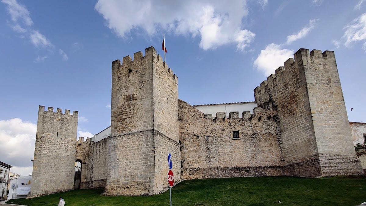
The surviving castle and defenses form a dispersed archaeological and architectural complex within the modern town. The original walled settlement covered about five hectares, but much of its circuit has disappeared, been demolished, or been incorporated into later buildings. The Almohad walls were made of taipa, a rammed-earth technique using compacted earth to create substantial wall sections. Their former route is also preserved by streets laid out while the defenses still stood and retained after parts of the walls were removed. Surviving fragments, towers, buried foundations, reused masonry, and sections of rampart walk appear throughout the historic center.
Walls and towers of the castle enclosure
Curved wall and three towers
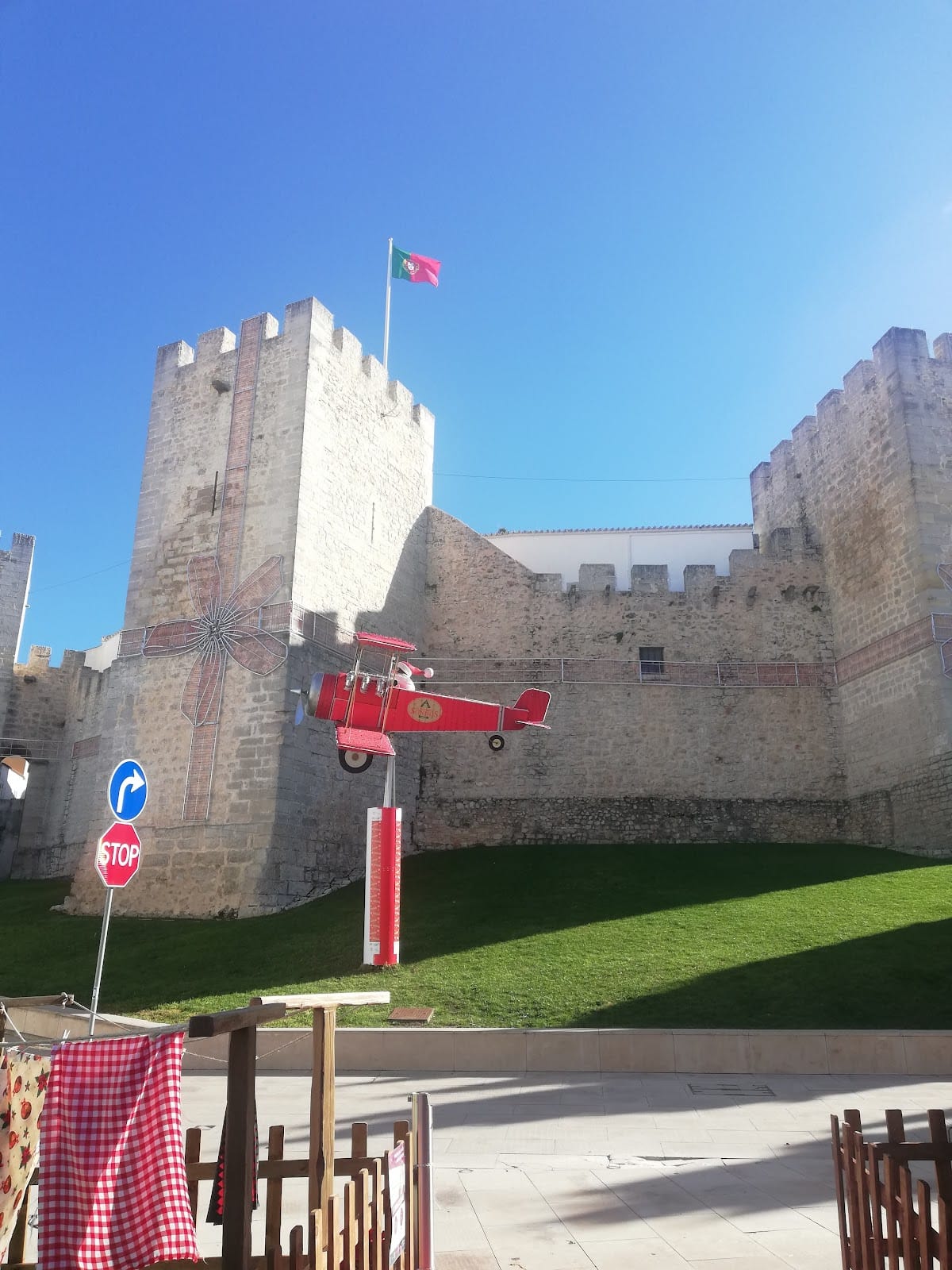
A principal surviving wall fragment curves through the site and includes three towers. The northern tower is an albarran tower, a structure projecting outside the main wall and linked to it by a bridge. It is one of two surviving towers of this type in Loulé. The central tower is attached to the outer face of the wall, while the southern tower has a rectangular plan and is partly incorporated into the wall. A rampart walk runs along the wall top and connects the towers. The masonry albarran tower beside Rua da Barbacã preserves indications of Islamic influence, although the surrounding castelejo belongs to the post-conquest castle. The surviving wall section probably marked the boundary of the former alcazaba.
Buildings beside the southern wall
South of the castelejo, a wall section supports a two-storey building facing Rua das Bicas Velhas. Its upper floor was rebuilt relatively recently, probably during the 20th century, while the older ground floor contains substantial arches that supported larger structures. This level communicated with an enclosure to the north, which was linked to the southernmost castle tower. Traces of an earlier arched doorway survive in that tower, and another blocked arched doorway in the ground floor faces the buildings known as Casas do Castelo.
Immediately south of Rua das Bicas Velhas, part of the wall remains behind the houses of Rua Garcia da Horta, together with a tower lower than the surrounding roofs. The wall continued toward Calçada dos Sapateiros, where traces survive in the street and inside buildings. Between the castelejo and the street opposite the Chapel of Our Lady of the Conception, other wall fragments are attached to buildings, including the courtyard known as Casas do Castelo. These buildings were used as barracks by a dragoon regiment, a military unit whose soldiers traditionally fought either mounted or on foot, during the 18th century.
Walls along Rua Martim Moniz and Rua Engenheiro Duarte Pacheco
The surviving section along Rua Martim Moniz is in comparatively good condition and has two distinct parts. The northern portion has lost its upper structure, while its lower half supports the ground of Jardim dos Amuados, a former municipal cemetery. The southern portion extends to the junction with Rua Engenheiro Duarte Pacheco and retains the complete wall and rampart walk, although its battlements have disappeared.
Further fragments along Rua Engenheiro Duarte Pacheco are attached to buildings and have lost their battlements and most of their rampart walk. The imposing Torre da Vela survives there as an earthen albarran tower outside the wall, together with its small connecting bridge. Later buildings now surround the tower.
Faro Gate and western defenses
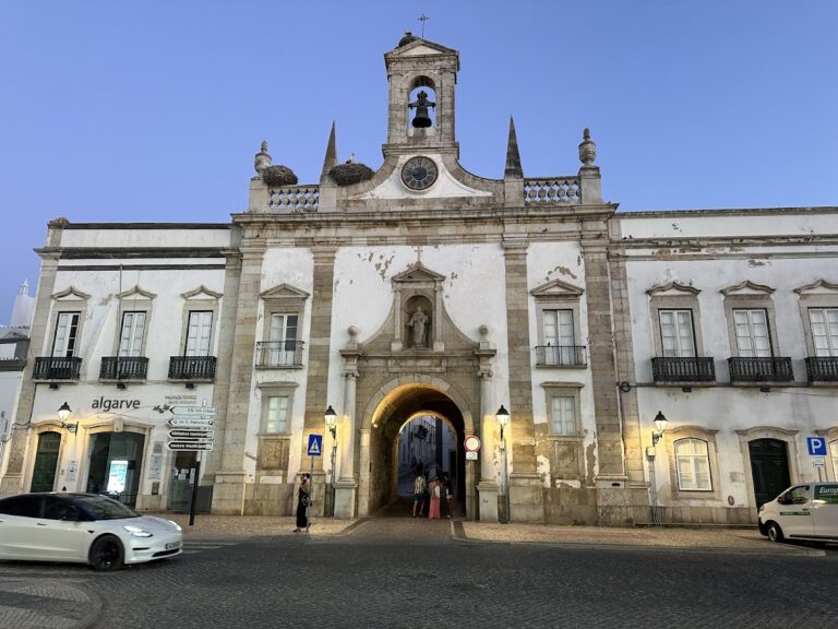
The former Faro Gate was one of the western entrances to the walled town. Although deeply altered, it retains features of Almohad construction. A later opening was made beside it for Travessa de Nossa Senhora do Pilar, while the original entrance was filled and blocked on its southern side by the Chapel of Our Lady of the Pillar. The chapel may incorporate materials from the gate complex, which included a tower.
A house with two windows and a roof terrace later occupied the site of the gate tower. Its stone-block masonry resembles that of the walls. The northern side of the former gate was discovered in 1969 during restoration work on the fortifications. Between the Faro Gate and Rua Primeiro de Dezembro, most of the wall has disappeared, leaving one tower and part of a wall with a rampart walk. Farther east, toward Avenida Marçal Pacheco, a small wall fragment remains attached to a courtyard. Muslim pottery, including large storage jars, was found there, and one of the jars is preserved in the municipal museum.
Gates and northeastern defenses
Vila Gate and the former Postigo Gate
The former Vila Gate stood at present-day Rua Pedro de Freitas, formerly Largo do Carmo, and was destroyed in 1873. Another entrance, the former Postigo Gate, also called the “treachery gate,” probably stood between the Municipal Market and the Town Hall in the area later called Rua Nove de Abril.
The wall probably formed an angle of about 90 degrees before running north toward the Municipal Market and then curving northwest. Unusually thick walls in buildings recorded in 1971, together with buildings misaligned with the modern street, may preserve parts of this former line. A tower identified by the local historian Ataíde de Oliveira as the Clock Tower was reportedly demolished around 1970 for the construction of a house on Rua Marçal Pacheco.
Town Hall and Chapel of Our Lady of the Conception
The wall formerly crossed the Town Hall building, leaving only a fragment behind the newer Clock Tower. The lower part of this tower is built in masonry resembling that of the old walls, while its upper portion is clearly modern. If a military tower existed at this location, it may have protected the entrance to Rua do Município, although this remains uncertain.
Further remains once extended along the northeastern boundary of the former Convent of Espírito Santo and ended beside the southwest wall of the Chapel of Our Lady of the Conception. The chapel reused part of the old fortification as a wall and may have been built on the site of a tower protecting the former Portugal Gate. Interior remodeling revealed two sections of wall and a tower belonging to the former Islamic defenses. The foundations of the Portugal Gate were also found, forming an elbow-shaped arrangement characteristic of Islamic fortifications. A windmill formerly stood opposite the chapel and may have been built over the foundations of a second tower protecting the gate.
Archaeological evidence and surviving urban traces
Islamic walls and buried foundations
Archaeological work in 2000 at a small house on Travessa de Martim Farto uncovered further Islamic walls and an associated rampart walk. Beneath the rear facade of Casa das Bicas, near Largo D. Pedro I, another wall was found measuring about three metres thick. It was built from local limestone blocks bonded with lime mortar. Additional investigations in the historic center have identified sections of the Islamic defenses and their rampart walk, adding buried evidence to the fragments visible above ground.
Parish Church tower
A surviving square-plan tower of the former medina was probably the minaret of the Islamic mosque. It was later adapted as the bell tower of the Parish Church of Loulé. The church area is probably the oldest part of the town, and the earliest known wall remains have been found there. The tower therefore preserves both the form of an Islamic religious structure and its later use within the Christian town.
The former alcaidaria, built on the probable site of the Islamic citadel, now contains the Municipal Museum of Archaeology on its ground floor, while other parts serve municipal cultural functions. Together with the isolated towers, partial walls, reused masonry, buried remains, and street alignments, it represents the surviving physical record of a fortified settlement reshaped by conquest, earthquake damage, demolition, and urban growth.