Bedrule Castle: A Medieval Stronghold in the Rule Valley
Site at a Glance
- Popularity
- Medium
- Country
- United Kingdom
- Primary era
- Medieval
- Eras represented
- Medieval
- Civilizations
- Kingdom of Scotland
- Site type
- Military
- Remains
- Castle
On this page13 sections
History
Comyn and Douglas control
Bedrule Castle is a ruined 13th-century castle built by the Comyn family in the Rule Valley, United Kingdom. On 30 September 1298, Edward I of England spent a night in Rule while travelling towards Jedburgh Castle, which surrendered to him on 17 October. In 1306, the Comyn lands were forfeited and the castle passed to the Douglas family, who made the Turnbulls its tenants.
The Turnbulls and border conflict
On 8 November 1511, James IV came to the Rule Valley and seized leading members of the Turnbull family. They submitted with drawn swords in their hands and willow switches around their necks, then were imprisoned in distant castles. In 1516, the Turnbulls joined Lord Home’s rebellion against Regent Albany, who governed Scotland on behalf of its monarch. A pardon issued that November by the young James V named several Turnbulls.
In July 1544, Master Clefforth, English soldiers, and men from Tynedale and Redesdale burned Bedrule and 15 or 16 other farms or farmsteads. The raiders took 300 cattle and 600 sheep from the Rule Valley, as well as three field guns, known as “basses,” belonging to the laird of Ferniehirst, a Scottish landowner. On 16 September 1545, English forces raided the area in retaliation for Scotland’s victory at Ancrum Moor earlier that year. This was part of England’s 1540s campaign to pressure Scotland into a marriage alliance, known as the Rough Wooing. Led by the Earl of Hertford and Sir Robert Bowes, 1,500 light horsemen raided along the Tyvyote and Rowle waters from 5 a.m. to 3 p.m., reaching six or seven miles beyond Jedburgh. They burned 14 or 15 settlements and much grain, with Bedrule among the places named. The castle may have escaped complete destruction in this attack.
Turnbull allegiance and the conflicts of the 1570s
After the Rising of the North, a 1569 rebellion against Elizabeth I, Thomas Turnbull welcomed Catholic fugitives at Bedrule, including Tristram Fenwyk, Robert Shafto, and Thomas Ogle. One night, English agent Robert Constable met Turnbull and Fenwyk by chance. Turnbull mistook Constable for another fugitive and invited him to Bedrule. On 19 April 1570, an English army under the Earl of Sussex burned the castle during the Marian Civil War, the struggle between supporters of Mary, Queen of Scots, and those of her son James VI. The house was described as belonging to Sir Andrew Turnbull. Lord Hunsdon said it had earlier sheltered Leonard Dacres, an English nobleman fleeing England. Elizabeth I and her ministers presented the invasion as a campaign against border outlaws, fugitives, and those who sheltered them, rather than an intervention on James VI’s behalf against Mary.
The Turnbulls supported Regent Lennox and his grandson James VI. On 29 August 1571, supporters of Mary declared Thomas Turnbull, laird of Bedrule, his son William, and other landowners forfeit for treason. In February 1572, Thomas signed a bond at Jedburgh pledging support for James VI, order on the English border, and opposition to the king’s enemies, especially Thomas Kerr of Ferniehirst. That November, Thomas attended the Edinburgh convention at which the Earl of Morton was chosen as regent. Soon afterward, the Turnbulls raided Robert Ker of Woodhead’s house at Ancrum, taking household goods, clothes, and farm animals.
Andrew Turnbull of Bedrule took part in the 1575 Raid of the Redeswire, an Anglo-Scottish border confrontation. Hunsdon sought to have Andrew sent to England as a hostage in exchange for English prisoners held by Regent Morton at Dalkeith Palace. Andrew’s companion Robert Shafto was shot dead during the confrontation.
Return and abandonment
The Turnbulls lost possession of Bedrule for a time. In May 1594, Harry Home of Coldenknowes sold the castle and its lands back to Walter Turnbull and his son William. Archaeological investigations indicate that the castle was permanently abandoned during the 16th century. Excavations took place in November 2021 and from September to October 2022 as part of the Twelve Towers of Rule project, launched in 2020 through Archaeology Scotland’s Adopt-a-Monument scheme. A geophysical survey followed in October 2022.
Remains
Setting and enclosure
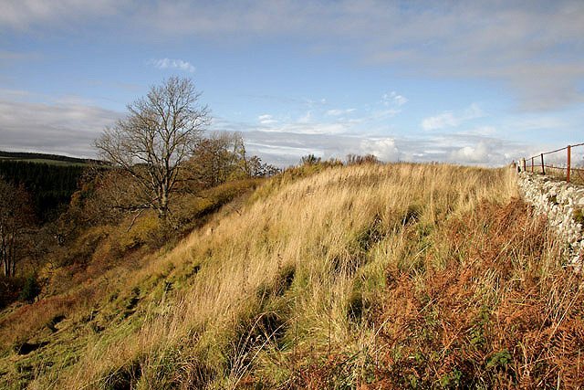
The castle occupies a partly artificial mound in the Rule Valley, with a broad view over the surrounding countryside. Rule Water follows the west side of the bluff, and the parish church stands about 200 yards to the southeast. The entrance appears to have been on the northwest, where two towered gatehouses may have defended access. A probable oval enclosing wall contained houses and smaller enclosed areas. Its stated northeast-to-southeast measurement is 200, though the unit is unclear; its transverse width is given as 130 feet. The site is now formed of grassy mounds and protruding stones. A wall extending northeast from the southwestern circular tower divides the ground unevenly, while cultivation has disturbed the northeastern area.
Towers and survey evidence
A circular tower stood at the southeast end of the castle, with two more circular towers to the west and southwest forming part of its defences. Two further towers may have occupied the northeastern half. Magnetic and electrical-resistance surveys detected a curved feature corresponding in position and shape to the eastern part of the enclosure earthwork. A broader, less distinct curve may have enclosed the main castle earthwork and continued an earthwork west of the dividing wall, although its date is uncertain. Several rectangular features west of the wall are thought to mark the keep, the castle’s principal fortified stronghold. In the northern survey area, other readings may indicate structures or walled enclosures added later. Areas of high resistance in the southern part of the eastern field may reflect rubble or buildings, while linear features there could be drains or trackways. Their dates and relationship to the castle remain uncertain.
Excavated structures and deposits
Keep corner
Trench 2 examined the southwestern corner of a square earthwork generally identified as the keep. Extended northwest by two metres during the 2022 work, the trench measured four by two metres. It exposed mixed collapsed material and two unmortared stone walls, each about two metres thick, meeting to form the castle’s southwest corner. Layers of soil suggest that at least part of the castle was damaged before abandonment; soil accumulated before the walls later collapsed. Cut stones from the castle, including facing blocks, floor slabs, and door and window lintels, were reused in the nearby church, the minister’s house, and local walls.
Banks and rubble
Trench 1, measuring one by 6.5 metres, crossed a curved bank running southeast to northwest. Stone lines at its northeast and northwest ends may be collapsed walls, but their interpretation remains uncertain. Trench 3 crossed a raised bank with stones visible on its surface. Beneath it were rubble layers and irregular stones that may belong to a partly fallen wall. The rubble had been disturbed after the castle’s destruction or abandonment, probably when local people took cut stone for reuse.
Northeastern corner
Trench 4 crossed the space between two low banks in the castle’s northeastern corner. It revealed a rough cobbled surface beneath gravelly clay, which may have formed an entrance to a large tower. Several pieces of post-medieval pottery, from the period after the medieval era, were also recovered.
Square structure within the enclosure
Trench 5 crossed the southern wall of a separate square feature inside the enclosure. The wall is 1.8 metres thick and has been assigned to an early-14th-century phase of the castle. Large stones facing its exterior are thought to belong to the wall’s initial construction, probably in the mid-to-late 13th century.