Tunnel of Eupalinos: An Ancient Aqueduct on Samos
Site at a Glance
- Popularity
- Very High
- Country
- Greece
- Primary era
- Classical
- Eras represented
- Classical, Medieval
- Civilizations
- Ancient Greek, Byzantine, Roman
- Site type
- Infrastructure
- Remains
- Aqueduct
On this page16 sections
History
The Tunnel of Eupalinos is an aqueduct, a system for carrying water to a settlement, built by the ancient Greeks in the mid-sixth century BCE on Samos, Greece. It carried fresh water through Mount Kastro to the island’s ancient capital, now Pythagoreion. The engineer Eupalinos, son of Naustrophos and a man from the Greek city-state of Megara, directed two teams digging toward one another from opposite ends. The exact construction date and the identity of the project’s patron remain uncertain. One proposal connects it to an early-sixth-century government that displaced the Geomori, a Samian political group, and gave citizenship to many Megarians, possibly including Eupalinos.
In his Histories, the fifth-century BCE writer Herodotus names Eupalinos as the builder and presents the tunnel as one of three outstanding works on Samos. He describes the aqueduct as operating when he visited the island around 460 BCE. Herodotus discusses it in his account of Polycrates, the sole ruler of Samos for much of the period around 540–522 BCE, but does not say that Polycrates commissioned it. The Homeric Hymn to Apollo, with its reference to “watered Samos,” may also allude to the water system.
Pythagoras, the Greek philosopher and mathematician, has sometimes been proposed as a contributor to the project’s calculations. That possibility remains conjectural; it has also been questioned because Pythagoras may have left Samos after disagreements with Polycrates.
Military use and decline
Carrying water underground helped protect the supply from enemies who might otherwise have cut it off. The tunnel may also have offered an escape route. In 439 BCE, however, Athenian forces entered through it and sacked the fortified city. The aqueduct supplied Samos for about 1,100 years. Sediment gradually impaired its flow, and although the system probably remained in reduced use during the Byzantine period, the later history of the eastern Roman Empire, it had stopped operating by the seventh century CE.
During the seventh century, the tunnel’s southern section was adapted as a defensive refuge. A cistern, or water-storage reservoir, was built underground to collect water seeping from the rock. A later supply system on Mount Kastro’s western and southern slopes gathered rainwater in another cistern. Clearing sediment and repairing local collapses were recurring needs. Further repairs and alterations took place in the Hellenistic era, after Alexander the Great’s conquests and before Roman rule, and under the Roman Empire.
Rediscovery and conservation
Nineteenth-century scholars searched for the aqueduct after reading Herodotus. Victor Guérin located its spring and the start of its channel in 1853. In 1882, a monk from the Agia Triada monastery made an important discovery. An effort that year to clear the tunnel and restore its water supply proved impractical, but the work allowed the archaeologist Ernst Fabricius to investigate the route. He published his findings in 1884.
Ulf Jantzen led extensive excavations from 1971 to 1973, removing silt along the tunnel’s full length. Hermann J. Kienast later conducted a detailed survey measuring positions and elevations precisely. Conservation has included cleaning, strengthening walls, and protecting the underground environment. The tunnel is part of the UNESCO World Heritage property Pythagoreion and Heraion of Samos, inscribed in 1992 for its evidence of cultural exchange and of a civilization. In 2017, the American Society of Civil Engineers named it an International Historic Civil Engineering Landmark.
Remains
The aqueduct crosses Mount Kastro in a route that includes a spring, a buried channel approaching from the north, the main tunnel, and a water channel below its floor. The main passage extends 1,036 metres through hard limestone. Its excavation reflects the need to reach the spring from the ancient city while keeping the watercourse underground.
Spring and northern approach
Spring reservoir
The spring lies near Ayiades at about 52 metres above sea level and once discharged approximately 400 cubic metres of water a day. It feeds through two rectangular openings, each 28 by 26 centimetres, into a roughly oval reservoir. Fifteen large stone pillars support a roof of massive stone slabs. Building the reservoir appears to have lowered the spring outlet by several metres. Before the nineteenth century, a church dedicated to St John was built above the reservoir, further concealing the spring.
Northern channel
From the spring, a buried channel follows the hillside for about 890 metres to the tunnel’s northern entrance, although the direct distance is only about 370 metres. Cut into bedrock, it measures roughly 60 to 70 centimetres across and about 5 metres deep. Stone slabs covered the channel before it was buried, and inspection shafts provided access along the route. Beneath a small hill, the final 150 metres were made by digging vertical shafts 30 to 50 metres apart and connecting them with a short tunnel.
Main tunnel and watercourse
Excavated passage
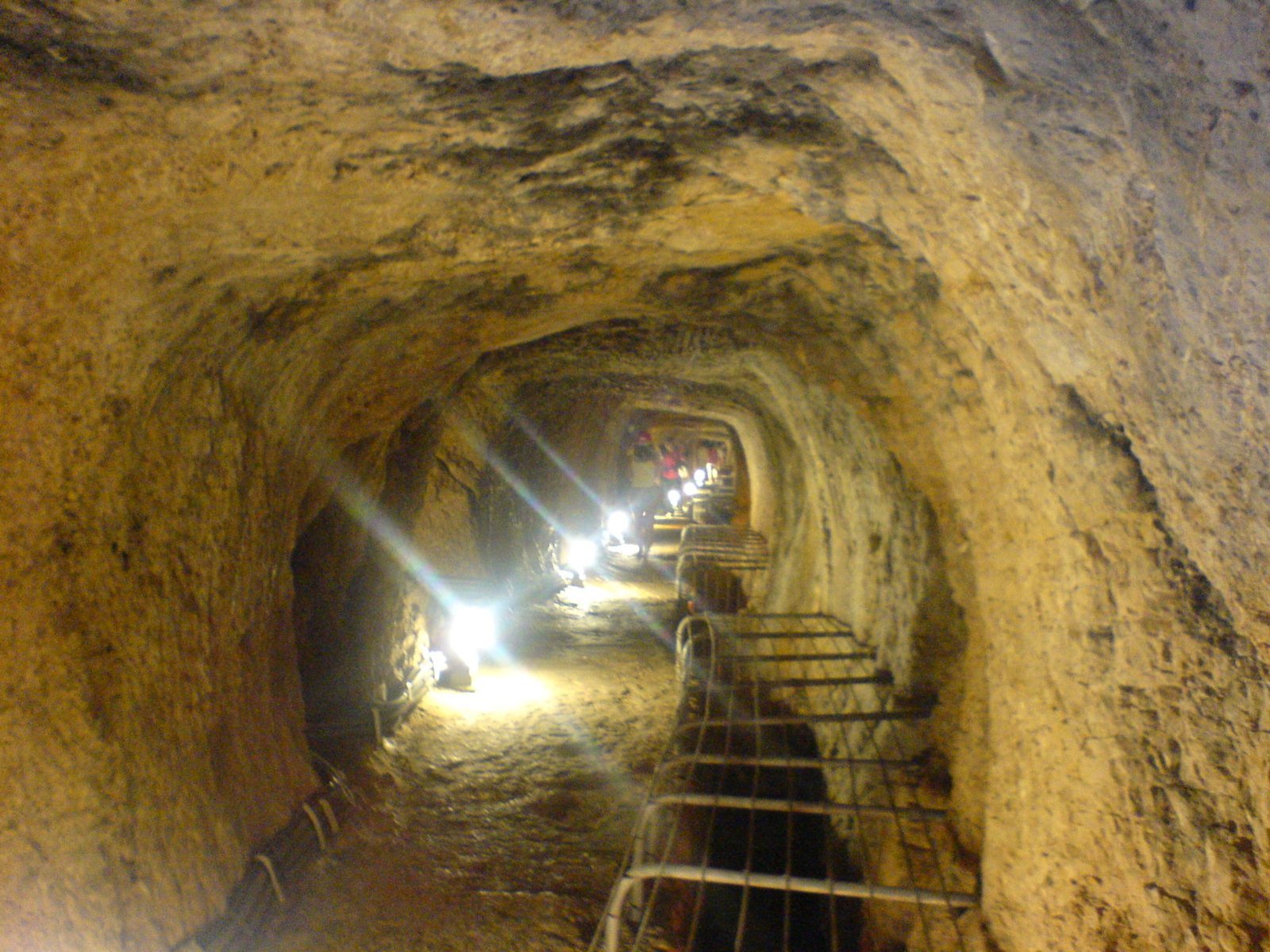
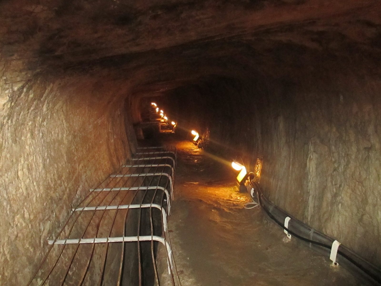
The main passage is generally about 1.8 metres wide and 1.8 metres high. It was cut through hard, partly crystalline limestone whose nearly horizontal layers helped the excavation. Most of the passage is not lined with masonry, and the exposed rock remains in good condition. The southern half is larger than the northern half, where some narrow stretches allow only one person to squeeze through. Stone slabs also line the access passages.
Stone-slab roofs protect three parts of the tunnel from rockfalls. Two sections near the northern end have a combined length of 153 metres; a third section at the southern end is 12 metres long. Large slabs face the walls of the northern sections, while the southern section uses polygonal masonry, made from stones with several-sided faces. During the Roman Imperial period, when Rome was ruled by emperors, builders reinforced other sections with barrel vaults, continuous arched roofs made of small stones and plaster.
Lower water channel and pipes
The nearly level floor of the main passage lies about 3 metres above the water level at the spring. A separate channel beneath the eastern half carries the water. Its depth increases from about 4 metres at the northern end to 8.5 metres at the southern end, and its downward gradient is approximately 0.45 percent. Vertical shafts link the two levels at intervals of about 10 metres. Workers used them during construction, and later for inspection; material removed while digging the lower channel was deposited in the main passage.
Water flowed through sections of terracotta, or fired clay, pipe about 71 to 73 centimetres long and 24 to 26 centimetres in diameter, with walls 2 to 2.5 centimetres thick. The sections fitted together with lime mortar, and roughly 5,000 were needed. Their upper quarters were cut away to allow sediment to be cleaned out; some also had covered maintenance openings. A break near the northern entrance let large amounts of mud enter the pipe and required frequent clearing.
Excavation and alignment
Survey marks and working methods
Painted marks on the tunnel walls preserve signs of the survey. Three on the eastern wall indicate positions for vertical shafts. Letters in sequence on the western wall recur at intervals of 20.59 metres, probably marking Eupalinos’ basic distance unit, one-fiftieth of the planned route. Workers dug by hand with iron chisels and hammers, and the confined passage could accommodate only two diggers at once. They may have included enslaved captives, particularly people from Lesbos. Oil lamps found during archaeological work show that lamps were used underground. Estimates for construction range from about 5 to 15 years, with roughly 10 often proposed; one calculation gives a minimum of eight years.
Two headings meet underground
Eupalinos established a line across the mountain and used northward and southward lines to guide the two crews. The route passed slightly west of the steep summit, where the ridge was more regular. Workers checked their course by sighting toward the entrances, and a notch cut into the rock in the southern half restored a sightline after a deviation.
About 273 metres from the northern entrance, weak, waterlogged rock forced that crew to turn west. They laid out the detour as a triangle with angles of 22.5, 45, and 22.5 degrees. After a measurement error carried the heading too far, it was redirected east. The southern crew kept to a straight course for 390 metres. Eupalinos used a 20.59-metre unit for distance and a 7.5-degree unit for directions.
The two routes join near the mountain’s centre in an offset bend, bringing the passages together at almost a right angle. Eupalinos adjusted both directions to make the possible meeting area about 17 metres wider. Near the junction, the northern passage’s roof rises by about 2.5 metres while its floor stays level; in the southern passage, the roof stays level and the floor drops about 0.6 metres. These precautions against a mismatch in height proved largely unnecessary, since the two sides differed by only a few decimetres. The crews may have been able to hear each other from about 12 metres away.
Southern continuation and water storage
Channel toward Pythagoreion
Shortly before the southern entrance, the water channel branches from the main tunnel and continues underground eastward toward Pythagoreion. About 500 metres of this branch have been excavated, and its full length is estimated at roughly 1,000 metres. Two large hillside fountains within the town appear to lie along its course. Each had a reservoir and a basin from which people could collect water.
Refuge cistern
A cistern about 400 metres from the southern entrance collected water dripping from a vein in the rock. Its position and function relate to the reuse of the southern tunnel section as a refuge.