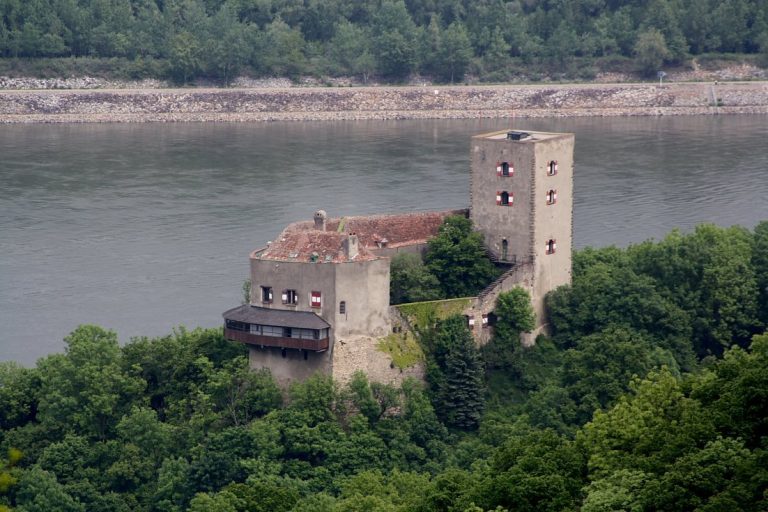
Comagena: A Roman Cavalry Fort on the Danube Frontier in Austria
Site at a Glance
- Popularity
- Medium
- Country
- Austria
- Primary era
- Classical
- Eras represented
- Classical, Medieval
- Civilizations
- Roman
- Site type
- Military
- Remains
- Fort
On this page23 sections
History
Comagena was a Roman cavalry fort on the Danube frontier at present-day Tulln, Austria, established in the late first century AD in Noricum, the Roman province of the eastern Alpine and Danube region. Its position allowed the garrison to oversee an important crossing of the Danube and the surrounding Tullnerfeld.
Foundation and stone fort
The fort was probably founded during the reign of Domitian, perhaps around AD 84. Its first defenses were made of timber and earth, and the camp was likely built by the Ala I Commagenorum, a cavalry regiment transferred from Commagene, an ancient kingdom in southeastern Anatolia. The unit’s transfer date and route are uncertain. This initial fort was used for about 30 years and received repairs before a stone fort replaced it in the early second century, during Trajan’s reign.
An inscription recovered during work on the eastern gate in 2000 names the cavalry regiment and associates the gate’s stone construction with Trajan’s reign. A fuller reading dates an otherwise unidentified building to AD 104 and gives the unit’s name as Ala (prima) Commagenorum Antoniniana. The honorific Antoniniana was added under Caracalla in the early third century, indicating the regiment’s presence at Tulln at that time. Inscriptions name the unit into the late third century, after which its history is unknown.
Later Roman occupation
Comagena served as a base for cavalry and, later, a Danube fleet. The Tabula Peutingeriana, a schematic map of Roman roads, and the Antonine Itinerary, a record of routes and distances, both refer to Comagena or Comagenis. Their route details differ. The late Roman Notitia Dignitatum, a register of offices and military units, lists lance-armed troops and a cavalry formation associated with Comagena. The Vita Sancti Severini, a text about the Christian monk Severinus, also mentions a nearby town called Comagensis.
The fort underwent several rebuilding phases. Repairs to the eastern gate and its towers point to episodes of damage or fire in the third century. Coin hoards place two such disturbances shortly after AD 258 and 283; civil conflict and struggles for imperial power are considered more likely causes than attacks from outside the empire.
A major refurbishment began between AD 337 and 371 under Ursicinus, a senior commander responsible for a frontier region. A serious fire in the second half of the fourth century destroyed the eastern gate and may have spread through much of the fort. Rebuilding followed quickly, and the southern passage of the gate was blocked. By the late fourth century, civilians occupied much of the fort, while a smaller garrison remained. The Vita Sancti Severini identifies its last troops as Germanic foederati, groups serving Rome under treaty. The fort was destroyed around AD 400, although civilian settlement continued into late antiquity.
End of Roman rule and medieval reuse
The Vita Sancti Severini recounts an earthquake during Severinus’s stay at Comagena. Evidence from the cemeteries indicates that the fort was abandoned after the campaigns against the Rugians, a Germanic people active in late antiquity. The Romanized population probably left following an order from Odoacer, a Germanic ruler in Italy, likely around AD 488.
Resettlement during Charlemagne’s campaign against the Avars in AD 791 has been proposed, but is not certain. Occupation is supported by archaeological evidence by the tenth century. A medieval castle was later built on the Roman ruins and converted into a monastery.
Rediscovery and archaeological work
Roman finds in the Tulln area attracted notice from the sixteenth century. In 1861, relief stones were recovered from debris from the demolished Vienna Gate, where they had apparently been reused in the town’s medieval defenses. A large cemetery, chiefly containing cremation burials, came to light near the railway station in the late 1860s, and further graves were excavated in the 1880s.
The first planned excavation took place in 1928, the year Tulln’s local museum was established to collect archaeological finds. Construction and rescue excavations after the Second World War revealed cemeteries south and west of the old town, as well as a hoard of more than 1,700 Roman coins. Systematic recording began after 1950. Excavations in 1980 exposed the eastern gate and remains of the earliest fort; work from 1991 to 2007 mapped further walls, buildings, ditches, settlements and burial grounds. In 2021, the archaeological site became part of the UNESCO World Heritage property Frontiers of the Roman Empire: The Danube Limes.
Remains
Comagena stood on a firm gravel terrace beside low-lying alluvial ground near the Danube. The fort’s short side faced the river, which gradually eroded the northern edge and removed about one-fifth of the camp, including its northern defenses. Before that loss, the stone fort had a rectangular plan and covered an estimated 4.2 to 4.5 hectares. Its remains include successive walls and ditches, defensive towers, internal buildings, civilian settlements, roads and cemeteries.
Fort walls and gates
The earliest enclosure
The first fort was built of earth and timber. Excavation exposed a sun-dried mud-brick wall, around one metre high and preserved for about 30 metres, resting on a foundation of loose-laid rubble. Postholes along its top indicate that it carried a wooden fence. A broad earth rampart rose against the wall from the west. The wall’s slight westward curve suggests an irregular early layout. Mortar masonry added over part of it shows that the defenses were adapted before the stone fort was constructed.
Postholes associated with the early entrance suggest towers around 3.3 metres wide. A central timber divider is thought to have separated two gate passages. Part of the outer ditch and concealed defensive pits were also identified. Mud-brick fragments in the western ditch suggest that the early western wall extended approximately as far as its later stone successor.
Stone walls and ditches
The fort’s defenses changed over time, with phases that used a double ditch, a single ditch with an outer rampart, and, in late antiquity, a V-shaped ditch. The southern perimeter wall, built from stone and brick fragments set in mortar, was about two metres thick. Along the western side, excavators traced a well-mortared stone wall about 1.2 metres wide, surviving in places to 2.2 metres above its foundation. Four ditch systems were identified along this side. Near a roadway, the ditches became shallower and ended; their fills above the road indicate that an earth bridge crossed the defenses.
The eastern gate
The eastern gate was about 22 metres wide, with carriage passages roughly 4.2 metres across. Its two rectangular towers projected about 1.8 metres beyond the fort wall. Each measured 5.7 by 7.45 metres externally and 3.3 by 5.1 metres internally, and probably stood about four metres high. Their front walls were 1.2 to 1.3 metres thick, while the other walls were about 1.1 metres thick. Each tower had a doorway on its western side, a smooth floor and plain interior plaster.
The gate’s outer walls were plastered with raised strips painted yellowish to imitate large cut-stone blocks. The transverse arches of the vaulted passages were painted red and white. Up to about two metres of masonry survives in places. The adjoining fort wall was about 1.5 metres thick and was later reduced to its foundations. In late antiquity, the blocked southern passage was adapted for living or storage.
Towers and buildings inside the fort
Corner and intermediate towers
Late Roman defenses included towers projecting beyond the walls, with rounded fronts, and fan-shaped towers at the corners. The southwest and southeast corner towers date to the middle of the fourth century. The southeastern tower, with walls up to 1.65 metres thick, was built over an earlier wall about 60 centimetres thick, dated to the second or third century. It survived to a height of 2.5 metres and stood beside an outer V-shaped ditch. Renewals of its white mortar floor indicate repeated use. Later occupation surfaces show that the area was used from the Carolingian period into the thirteenth century.
Drainage work in Bonvicini Street exposed part of a second horseshoe-shaped tower on the southern wall. The remains belonged to the western side wall of the eastern of two intermediate towers on the south front, between the corner towers and the rear gate.
The Salzturm
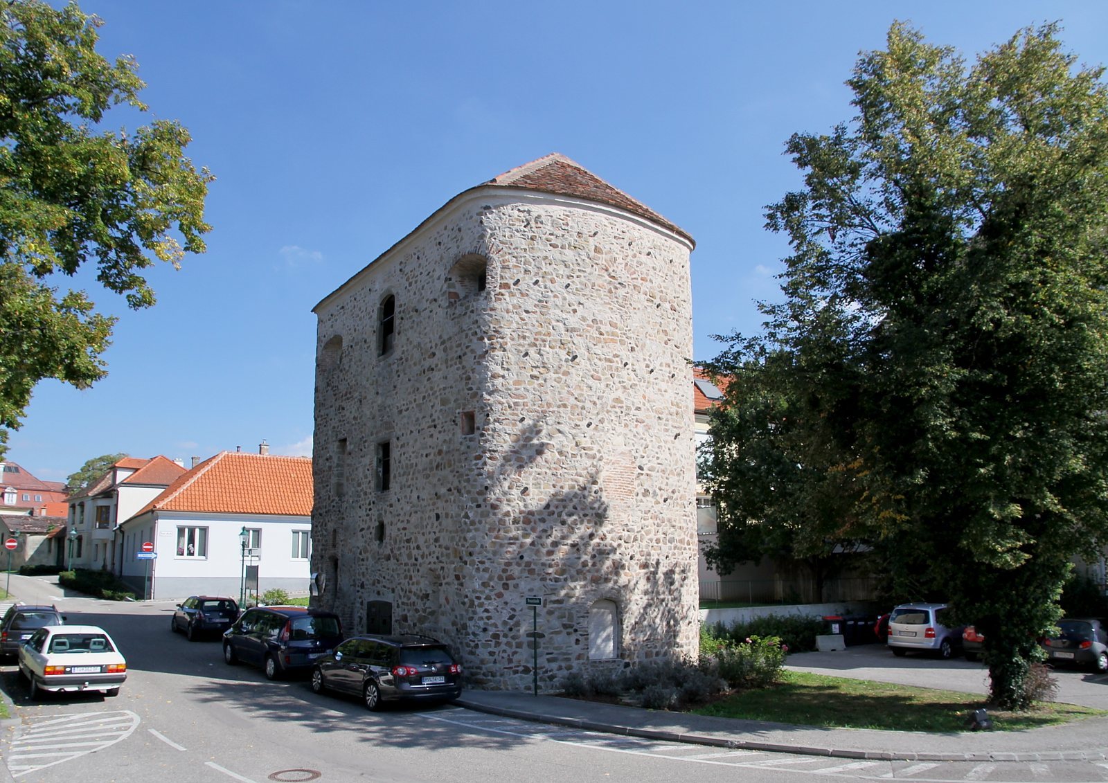
The Salzturm, also known as the Roman Tower, projects from the western wall near the modern Danube bank. Built in the first half of the fourth century, it survives largely in Roman masonry to the roofline. Its masonry is about 10 metres high and 1.4 metres thick, and the tower projects 3.1 metres into the fort. It had four levels, including a cellar, and its original entrance was on the east side. A blocked opening and marks in the adjoining wall indicate the former connection to the wall-walk. Holes in the exterior held construction scaffolding, and the ancient facade was plastered. Its masonry surface was conserved in 1984. The name Salzturm recalls its later use as a salt store in the eighteenth and nineteenth centuries.
Barracks, headquarters and streets
Excavations in the southeastern part of the fort found east-west-oriented barrack walls with traces of painted plaster. One wall survived to about 0.9 metres high and had apparently been dismantled in late antiquity. The fort’s headquarters building, the principia, was located at the former provincial hospital. Excavators also identified the principal street running through the fort, as well as a camp road at Ländgasse.
Civilian settlements and roads
Western settlement
The western civilian settlement included earth cellars, wells, deep pits, a Roman row house and buildings from several periods. In one area, a pit cut through the foundation trench of an earlier timber building and lay beneath later stone-building remains. Coins from the settlement date from AD 182 to 367/375. Coins of Domitian and Nerva found in the area indicate activity from the fort’s early phase.
Southern settlement
Remains of a second civilian settlement were identified near the Roter Turm, the charnel house, the parish church and Kirchengasse. Roman occupation layers beneath the parish church extended to a depth of three metres. At Kirchengasse, excavators found rooms with mortar floors and underfloor heating.
Roads and rural supply
The westbound road from the fort passed near Ländgasse and followed an alignment reflected in present-day Albrechtgasse, continuing toward Zwentendorf and Traismauer. The principal frontier road linked Carnuntum and Lauriacum across the Tullnerfeld. A further road linking Comagena to this network is associated with a milestone at Nitzing. Rural estates in the surrounding area supplied the garrison with food. One example was a farm estate at Freundorf, established in the second century.
Cemeteries
Southern cemetery
The southern cemetery lay between Frauentorgasse and the railway line toward the town park. It contained more than 300 burials from the early fourth to the first half of the fifth century. Excavated grave types include simple earth graves, graves lined with stone slabs, tile-covered graves and masonry shaft graves.
Western burial grounds
Two western cemeteries lie about 200 metres apart. Their dating remains debated, with the northwestern burial ground generally linked mainly to the fort’s earlier period and the southwestern one to late antiquity. Excavation across about 6,000 square metres in the northwestern cemetery uncovered roughly 164 graves, including five horse burials, dating from the late first to the fifth century. Cremations predominate from the late first to the third century; inhumations are more common in a later phase beginning in the late third or early fourth century.
Near Schießstattgasse, excavators uncovered part of the western cemetery’s burial road and 112 graves beside it. The road followed the line of the present street and led west from the fort. Most of the graves were cremations dating from the first to early third century, with a later group from the fourth century. A separate child’s grave of the middle Roman imperial period was found near Rosenarcade.
Eastern graves
Six east-west-oriented inhumations near Lazarettgasse, east of the fort, contained grave goods dated to the second or third century. Their location suggests a burial ground beside the eastern exit road.
Religious and other finds
A bronze ring with a raised panel bearing a Christogram, a Christian symbol formed from letters representing Christ’s name, was recovered at Wildacker in 1928 and provides evidence of early Christians at Comagena. A white-marble relief dedicated to Mithras was found in the Tullnerfeld around 1730, possibly at St Andrä or Königstetten. Its inscription dedicates it for the welfare of Comagenis and its inhabitants, or possibly of Commagene; the relief is now displayed at the Tulln Roman Museum. A Roman funerary lion is built into the south tower of Tulln’s parish church.