Segedunum Roman Fort: Hadrian’s Wall’s Eastern Fort
Site at a Glance
- Popularity
- High
- Country
- United Kingdom
- Primary era
- Classical
- Eras represented
- Classical
- Civilizations
- Roman
- Site type
- Military
- Remains
- Fort
On this page19 sections
History
Segedunum Roman Fort was a Roman auxiliary fort at Wallsend in the United Kingdom, on the north bank of the River Tyne. Built around AD 125–127, it became the easternmost fort in the chain along Hadrian’s Wall and remained in use for about 300 years, until around AD 400.
A Roman frontier fort
Emperor Hadrian, who ruled from AD 117 to 138, ordered a frontier barrier across northern Britain in AD 122. Its eastern end was first planned for Pons Aelius, the Roman fort and bridge at the site of modern Newcastle upon Tyne. Around AD 125–127, the Wall was extended about 6 kilometres through Byker to Segedunum. The extension helped protect the crossing at Pons Aelius and the surrounding area, including settlements of the Brigantes, a Celtic people of northern Britain. Segedunum also offered a clear view east along the Tyne toward Arbeia, a Roman fort near the river’s mouth at South Shields, and west toward the bridge. The river itself formed a natural defense at the Wall’s eastern end.
The fort stood on a narrow plateau above the Tyne and formed part of a frontier system of 16 forts. In the late second century, the region belonged to Britannia Inferior, one of Roman Britain’s administrative provinces; from the fourth century it was part of Britannia Secunda. The modern name Wallsend reflects the settlement’s position at the end of the Wall.
An auxiliary cohort was a Roman military unit that served alongside the legions. Cohors II Nerviorum was stationed at Segedunum in the second century. In the third and fourth centuries, the partly mounted Cohors IV Lingonum occupied the fort. Each unit is described as having 600 soldiers: 480 infantry and 120 cavalry. Inscriptions connect construction work at the fort’s main gate with Legio VI Victrix, one of Rome’s large military formations. An inscription naming Legio II Augusta was also recorded at Wallsend, and a now-lost inscription attributed a section of the Wall to that legion.
After Roman rule
Roman troops withdrew from Hadrian’s Wall around AD 410. The region subsequently faced incursions by Picts, peoples of northern Britain, and Anglo-Saxons, Germanic peoples who settled in Britain after Roman rule. Segedunum was probably affected by the Saxon devastation of the north in AD 547. Civilians may have continued to use the fort, and pottery from its headquarters suggests possible Anglo-Saxon activity. The fort was probably abandoned by the time of the Norman Conquest of England in 1066. Wallsend may have been established farther inland to reduce the risk of raids arriving by ship along the Tyne.
Development and archaeological work
For centuries, the ruins served as pasture. Coal mining began nearby in the late eighteenth century, and a mining settlement developed. Terraced houses, followed by the Swan Hunter shipyard and the Simpson Hotel, covered much of the fort. By about 1884, development had almost erased it from view. The decline of coal mining and shipbuilding by the mid-twentieth century later made extensive clearance and investigation possible.
Excavation at the west gate began in 1929. The demolition of nineteenth-century housing in 1975–1976 allowed work across the southern part of the fort from 1975 to 1984; Charles M. Daniels investigated the southeast area in 1979. Excavations in 1997–1998 showed that the Roman fort had been built over an Iron Age settlement. A project begun in 1997 combined further excavation with the creation of a museum and archaeological display area. The museum opened in June 2000. Segedunum forms part of the Hadrian’s Wall UNESCO World Heritage Site, a recognition of the Wall’s cultural importance.
Remains
The stone fort covered about 1.7 hectares and measured 138 metres from north to south and 120 metres from east to west. Its roughly square plan had rounded corners, and it projected farther beyond the line of Hadrian’s Wall than the other forts along it. Excavation has exposed the southern half; Buddle Street and housing cover much of the northern area. The display area makes the layout legible through preserved foundations and stone and gravel markings.
The fort
Perimeter and gates
A stone perimeter wall, about four metres high, enclosed the fort. Six intermediate towers and four towers at the corners reinforced it. An earth bank against the inner face supported the wall and provided a walkway. Outside, a ditch about 6.4 metres wide was separated from the wall by a berm, the strip of ground between a fortification and its ditch, about seven metres across.
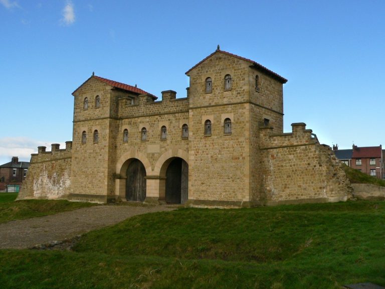
Four gates opened north, south, east and west. Each had two carriageways divided by a central pier, with a pair of square towers set behind the wall beside the entrance. The east and west gates stood north of the midpoint of their respective walls. The north, east and west gates lay beyond Hadrian’s Wall, while the south gate faced its inner side. The east gate was partly reconstructed in Wallsend Park in 1912. Excavation showed that the west gate and the adjoining stretch of Wall were built as one structure. A small postern, or secondary gate through the defenses, stood southwest of the west gate beside an intermediate tower.
Interior buildings and roads
The fort’s first stone-building phase, around AD 125, included the defenses and central buildings: headquarters, the commanding officer’s house, a granary, workshops, barracks and stables. A hospital near the west gate is considered probable. Infantry and cavalry barracks, along with buildings in the southern corner, were first built in timber. The barracks and stables were later rebuilt in stone, with the cavalry stables incorporated into their barracks.
Six infantry barracks and four cavalry barracks housed the soldiers. Infantry quarters occupied the forward part of the fort and cavalry quarters the rear. Barracks were divided into nine soldiers’ rooms, with larger quarters for officers at each end. The main east–west and north–south roads were interrupted or offset by central buildings. A road also ran around the interior beside the defenses, and another east–west road crossed the southern part of the fort. The headquarters and other principal buildings occupied the space between the barracks.
During a second building phase, dated AD 180–230, a small bath was added to the commanding officer’s house and a cistern was built by the west gate. The headquarters and granary were joined and extended by a hall running east to west. A hospital was constructed in the southeast corner, and the small postern was inserted into the west wall to provide protected access to the civilian settlement. A large reservoir near the west gate supplied fresh water and flushed the latrines; channels serving the hospital survive.
From the late third to early fourth century, most of the middle-period buildings were demolished and replaced by workshops and huts. Barracks were rebuilt with individual rooms instead of the earlier long, narrow spaces. The hospital site was occupied by simple rows of houses, and some interior areas were paved.
Hadrian’s Wall at Segedunum
The eastern extension
At Segedunum, Hadrian’s Wall met the fort at the southern flank tower of the west gate, then left it at the southeast corner and continued toward the Tyne for about 300 metres. It probably ended near the river’s high-water mark. A Wall built from the southeast corner extended almost two metres wide to the riverbank, at least as far as the low-water level. This section was narrower than other stretches, measuring about 1.98–2.29 metres across on a foundation about 2.4 metres wide. A lost inscription found near Wallsend around 1857 attributed its construction to Legio II Augusta. A memorial plaque marks the eastern end on the shipyard grounds.
The reconstructed stretch
North of Buddle Street, an 80-metre stretch of Wall at the fort’s northwest corner has been reconstructed to a height of about four metres. Stairs lead to a railed walkway. Part of the rear face is plastered and marked with red lines to resemble large blocks of stone, a finish also identified on original Wall fabric and at other frontier forts. A relief of a phallus forms part of the reconstruction. Original foundations remain near this stretch, with a few courses surviving closer to the Tyne.
Holes in front of the Wall held thorn scrub and probably formed an obstacle approaching the defenses. Most also contained post holes and may have belonged to a temporary timber barrier intended to protect soldiers building the stone Wall. Wooden stakes now mark the holes.
The bathhouse
Original building and reconstruction
The original bathhouse stood outside the fort, southwest of it in a hollow near the river, about 121 metres south of the southwest corner. A small stream ran through the hollow and may have supplied water. The bath was probably built around AD 120 and used for about 150 years; soldiers and civilians may both have bathed there. It was uncovered in 1814 during work to lay coal-wagon tracks, along with Roman coins and a cauldron. Exposure badly damaged the remains, which were later forgotten. Old maps and records helped identify their location beneath the former Ship in the Hole pub. Probing there in 2014 recovered Roman pottery, fragments of waterproof cement, parts of the heating system, building stones, wall remains and a well-preserved cold-water basin.
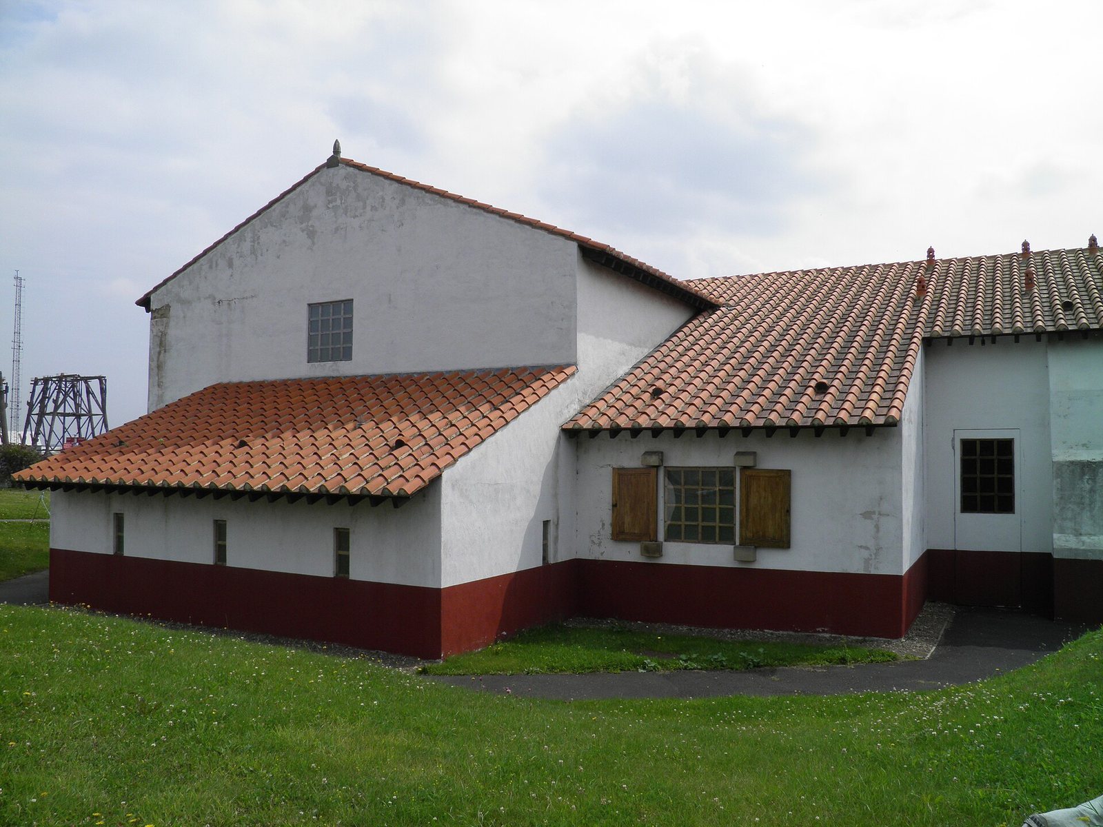
A reconstructed bathhouse was built elsewhere in 2014. Its design draws chiefly on study of the bath at Chesters and comparison with other military bathhouses along Hadrian’s Wall. On the east, an entrance hall served as a changing and exercise room, with niches for clothing. The communal latrine has seven stone seats above a flushing channel and a trough for cleaning sponges.
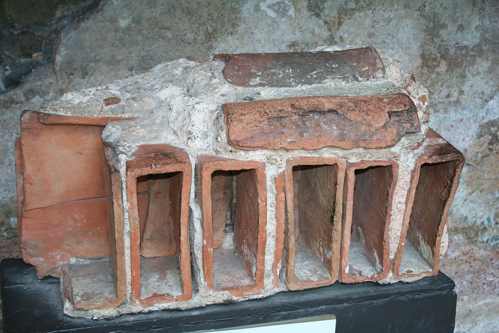
Two furnaces heated the hot-water pool, floors and wall channels. The reconstruction represents a hypocaust, a Roman system that circulated hot air beneath floors and through hollow wall tiles, with stacks of brick supports and cap tiles. An opening in the hot-room floor and wall reveals part of this heating arrangement. The heated rooms include a warm room and a hot room. Beside the latter, a small fountain has a Medusa-head waterspout, using the image of a figure from Greek mythology in its decoration; its design is based on a find from southern England.
The cold room has a basin sealed with waterproof cement. Marine-animal paintings take inspiration from Pompeian decoration, Roman art associated with Pompeii. A painted seated figure of Fortuna, the personification of fortune, holds a cornucopia, or horn of plenty. The figure is based on a bathhouse find at Birdoswald, and the wall niche follows an example from Ravenglass. A small adjoining garden contains plants used by Romans for cosmetics and medicinal purposes.
Settlement and religious evidence
The civilian settlement
A vicus, or civilian settlement associated with a Roman military site, lay northeast of the fort between it and the Wall. It extended westward along a military road for almost 600 metres, in an area now built over. Excavations revealed streets, evidence of craft work, possible pottery kilns and buildings dating to the third century. The settlement may have been defended during that century by a ditch and earth bank. Part of this defense was found about 65 metres west of the fort, south of the Wall; it may have turned south about 75 metres short of the Tyne. Another section was observed at the Swan Hunter shipyard in 2001.
The Wall bounded the settlement to the north, the fort to the east, the earth bank to the west and the river to the south. The settlement was abandoned in the late third century, although markets may have continued there from the fourth century.
Possible temple site
Southwest of the fort, about 40 metres from the bathhouse, a stone altar without an inscription, coins and an inscription found in 1783 suggest a possible temple site. The inscription, recovered from the northern foundations of Tynemouth Priory, refers to a statue erected in a temple and probably came from Wallsend. Twelve stones surrounded the altar and may have served as the pointer for a sundial.
Finds and archaeological display
Objects from the fort
Excavations recovered more than 700 ancient objects. Finds from the barracks include chain-mail fragments, brass pans, a drinking bowl and a portable shrine made of lead. Found in the cavalry barracks, the fourth-century shrine is 75 millimetres high and 36 millimetres wide, with two doors that close across its front. Its semicircular pediment, the upper part of a building façade, bears symbols of the sun god, including a wheel and whip. Inside, a relief shows Mercury, a god associated with commerce and travel, wearing a winged helmet and a cloak fastened with a round brooch. He holds an unidentified object in one hand and spreads the fingers of the other. A dolphin and bridled sea-horse appear at his feet; diamond patterns and stylized shells decorate the doors.
The commanding officer’s house yielded the severed head of a statue of Minerva, a goddess associated with wisdom and crafts, and a sculpture of Fortuna. A carved inscription stone came from the west postern, while pottery from the Anglo-Saxon period was found in the headquarters. Finds from the hospital include a candlestick and part of a stone toilet seat, the only such find in England. The reconstructed bathhouse seats were designed using the fragment as a model.
Site presentation
The archaeological display area preserves foundations of some interior buildings. Original blocks remain where excavation exposed them. Broken stones indicate fort foundations, grey gravel marks floors, and pink gravel identifies oval urine pits in the cavalry stables. Small gravel mounds mark hearths. Stone and gravel lines also trace walls and roads, while information panels identify the northeast corner, south wall and four gates.
The museum displays objects found at Wallsend and includes a 34-metre observation tower overlooking the site. A modern monument to the builders of Hadrian’s Wall stands at its eastern end.