Arch of Trajan: Roman Triumphal Gateway at Timgad, Algeria
Site at a Glance
- Rating
- 4.8
- Popularity
- Low
- Country
- Algeria
- Primary era
- Classical
- Eras represented
- Classical
- Civilizations
- Roman
- Site type
- Civic
- Remains
- Arch
On this page10 sections
History
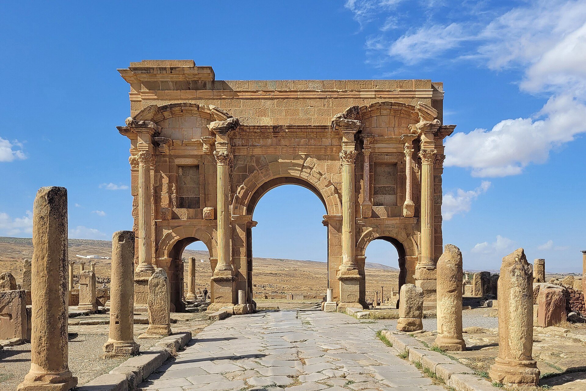
The Arch of Trajan is a Roman triumphal arch at Timgad in Algeria, founded in the context of the colony established under Emperor Trajan in AD 100. It stands at the western end of the city’s principal east–west street, where the road from Lambaesis, a major Roman military centre in North Africa, met the Decumanus Maximus, the main east–west road of a planned Roman town. The monument also served as Timgad’s western gate. Its surviving elevation is difficult to date precisely: its connection with Trajan comes from the foundation inscription, while its architectural form has been placed in the later second or early third century.
Foundation under Trajan
Timgad was founded as the colonia Marciana Traiana Thamugadi under Trajan, who ruled from AD 98 to 117. A fragmentary inscription from the arch’s attic states that the colony was established through Legio III Augusta, the Roman legion permanently associated with the military administration of North Africa, under the authority of the governor Lucius Munatius Gallus. The inscription establishes the monument’s association with the foundation of Timgad, but it does not directly state when the arch itself was built.
The surviving structure may have been constructed or completed after Trajan’s reign. One interpretation holds that it replaced an earlier Trajanic city gate and was rededicated in AD 203 under Septimius Severus, the emperor who founded the Severan dynasty. This remains a proposed reconstruction rather than a certain date for the monument. The arch’s forms have also led to a possible later second- or early third-century date.
Severan monuments and imperial memory
During the early third century, two monumental statue installations were set before the piers on either side of the central passage. Their inscriptions associated the dedications with Septimius Severus, his sons Caracalla and Geta, and two different themes. One monument honored the Concord of the Emperors, while the other was dedicated to Mars Augustus the Protector.
Lucius Licinius Optatianus paid for the statues and their bases when he obtained the perpetual priesthood of the colony. The amount assigned to the project rose from 20,000 to 35,000 sesterces. The dedication also included distributions, a communal meal, and games. After Geta was killed in AD 211, his name and titles were erased from the inscriptions and replaced by honorific titles for Caracalla. This alteration reflects the official removal of the condemned ruler’s name and honors from public monuments.
Road network and later antiquity
The arch continued to serve as a landmark within Timgad’s road system for centuries. Milestones found around the monument carry imperial dedications from the third century through the late fourth century. They include a stone for Claudius II dated to AD 268–270, a fragment possibly associated with Severus Alexander or Gordian III, a dedication to Valentinian I, Valens, and Gratian from AD 367–375, and a final stone naming Valentinian II, Theodosius I, and Arcadius from AD 388–392.
The position of these stones, together with the absence of recorded mileage figures, has encouraged the interpretation that distances on the road to Lambaesis were measured from the arch. This proposed function is based on the archaeological and inscriptional arrangement rather than on an ancient statement explicitly assigning that role to the monument.
Exploration and conservation
European travellers and explorers began drawing attention to the arch during the eighteenth and nineteenth centuries. James Bruce made a drawing in the late eighteenth century, and Adolphe Delamare depicted it in 1851, when much of its lower portion was still buried. Léon Renier discussed it in his report on Thamugadi, while soundings made by the officer Becker in 1853 revealed fragments of the attic inscription. Émile Masqueray studied and published those fragments and later carried out excavations at Timgad during the 1870s.
Systematic clearance later removed about 2.50 metres of rubble, exposing the ancient road pavement, the arch’s substructure, and arrangements around the monument, including the statue bases. The upper masonry and the vaults over the openings were provisionally consolidated because they were considered unstable. Fallen blocks from the hexagonal statue bases were also re-erected. The Arch of Trajan forms part of the archaeological site of Timgad, which has been on the UNESCO World Heritage List since 1982, and it is protected under Algeria’s cultural-heritage legislation and the permanent safeguarding plan for Timgad and its archaeological environment.
Remains
Gateway and architectural arrangement
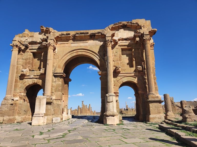
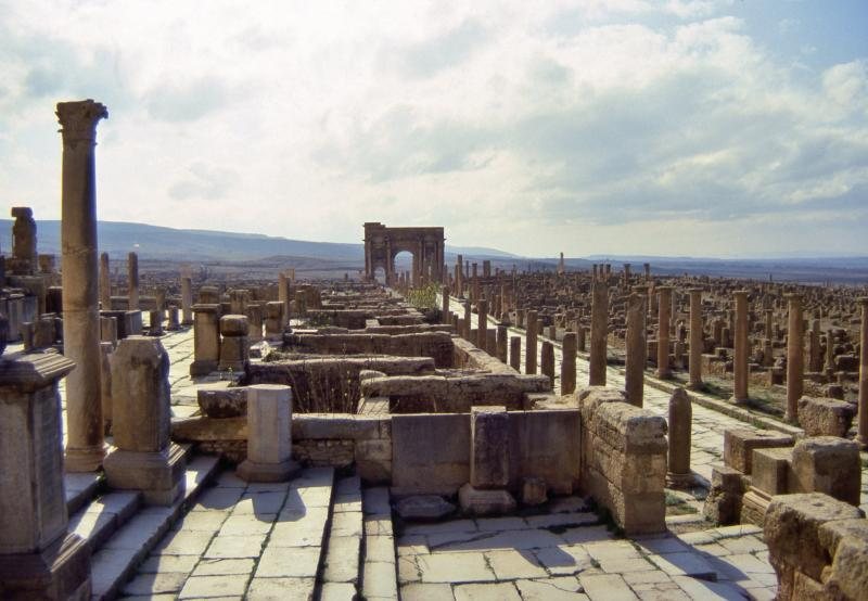
The Arch of Trajan is approximately 12 metres high and consists of three passages built into Timgad’s western urban axis. The central opening is wider and taller than the two side openings, measuring about 4.20 metres wide, 6.7 metres high, and 3.40 metres deep. Each side passage is approximately 2.50 metres wide and 3.8 metres high. The monument is built mainly from local sandstone, with white limestone from Menah and marble used for architectural decoration.
Detached Corinthian columns stand on high individual pedestals beside the openings on both façades. Each column corresponds to an engaged pilaster within the body of the arch, and the horizontal entablature, the architectural band carried above columns and openings, projects along their line. The columns do not stand at the outer corners. Their shafts are about 0.63 metres in diameter and are approximately 4.88 metres high, with bases about 0.33 metres high and capitals about 0.67 metres high. The shafts are fluted, and rounded bands or mouldings fill the lower parts of the grooves. Two capitals replace the usual volutes with eagles holding thunderbolts.
The stones forming the curved inner edges of the arches project beyond the width of the arch frames. Carved consoles with vegetal scrolls once supported the small columns that framed the niches above the side openings. These smaller columns were made of coloured marble, while their consoles were carved from white Menah limestone with acanthus and mask decoration.
Niches, attic, and inscriptions
A deep rectangular niche rises above each side opening. Each niche is about 1.50 metres wide, 1.40 metres deep, and 2 metres high. Small columns framed the recesses, and curved pediments crowned them. The niches were intended for statues, although the original figures had not survived by the time of the earliest studies. A fragment of a female torso in white marble was found roughly 10 metres in front of the western façade and placed in one of the best-preserved niches during consolidation. Its connection with that niche and its original position remain uncertain.
The entablature remained substantially intact at the end of the nineteenth century, but only part of the attic, the upper storey above it, survives. On the eastern façade, the surviving attic rises about 1.30 metres to the upper band, while its ends are partly hidden by the large curved pediments over the sides of the façade. The original upper crowning is unknown. A quadriga has been proposed as a reconstruction, but no surviving element described from the monument confirms it.
The western side of the attic carried a large inscription on a plaque estimated at about 1.10 metres high and 2 metres wide. It commemorated the foundation of the colony under Trajan and repeated, with a different arrangement of lines, the text of the inscription on Timgad’s northern gate. No corresponding inscription has been found on the eastern face. It may have fallen in antiquity, or that side may originally have contained an uninscribed slab.
Passages and ancient roadway
The central passage preserves deep wheel ruts in the ancient pavement. The ruts are approximately 0.30 metres wide, with their inner edges about 1.10 metres apart and an estimated wheel gauge of roughly 1.30 metres. Their gradual formation through repeated vehicle traffic is preferred to the idea that they were deliberately cut as guides. The side openings are interpreted as pedestrian passages. On the eastern side, they lead to two square platforms, each about 5 metres wide, aligned with the sidewalks beside the Decumanus Maximus. The western approaches are shaped by sloping ground and do not have comparable platforms.
Milestones and statue bases
Several milestones stood beside the road near the central passage. Their bases were rectangular blocks with circular sockets for the stone columns, and one base was returned to its ancient position during clearance. The milestones carry imperial dedications dating from the third century to the late fourth century, linking the gateway’s physical setting with the continuing maintenance and official use of the road.
Two hexagonal statue bases remain in place before the column pedestals flanking the central opening. Their upper blocks had fallen nearby and were re-erected. The inscriptions identify one dedication to the Concord of the Emperors and the other to Mars Augustus the Protector. The statues themselves are lost, so their precise original appearance cannot be reconstructed.
The combination of three passages, detached columns, pilasters, a projecting entablature, lateral niches, and curved pediments was regarded in an early twentieth-century study as an early example of an arrangement that later became widespread in Roman monumental architecture. That comparison does not establish a direct architectural connection with the Forum of Trajan or with the arches of Septimius Severus and Constantine at Rome.