Cividade de Terroso: A Fortified Castro Settlement in Portugal
Site at a Glance
- Rating
- 4.6
- Popularity
- Low
- Country
- Portugal
- Primary era
- Iron Age
- External website
- Open
- Eras represented
- Bronze Age, Iron Age, Classical
- Civilizations
- Roman
- Site type
- City
On this page10 sections
History
Cividade de Terroso is a fortified Castro-culture settlement in Portugal, near Póvoa de Varzim, founded during the Bronze Age on Cividade Hill. The Castro culture comprised the pre-Roman communities of northwestern Iberia, known for hilltop settlements, substantial defenses, circular houses, distinctive pottery, and regional exchange networks. Cividade de Terroso was established probably between 900 and 800 BC after inhabitants moved from the fertile plains of Beiriz and Várzea. Its position near the Ave River and less than 5 km from the Atlantic made it an important settlement for communication, production, and exchange.
Bronze Age Foundation and Expansion
The settlement grew on a hill approximately 152 m above sea level, with wide views across the surrounding region. Egg-shaped cesspits excavated in 1981 contained fragments of four vessels belonging to the period before the settlement was established. As Cividade de Terroso expanded, it became one of the major and most strongly defended Castro settlements in the region. Its territory was connected with three associated outposts. Castro de Laundos served as a surveillance position, Castro de Navais retained a fountain, and Castro de Argivai was a farming settlement on the coastal plain. Cividade de Terroso also stood about 6.3 km from Cividade de Bagunte, on the northern bank of the Ave.
Trade linked the settlement with Phoenician, Carthaginian, Greek, and Roman communities. Gold, tin, textiles, wine, glass, and ceramics moved through these contacts, while local inhabitants practiced agriculture, horticulture, fishing, gathering, pastoralism, metalworking, textile production, and pottery making. The settlement prospered particularly during the period of Carthaginian influence in southeastern Iberia. The coastal deity Cosus held an important place in its religious life and was later associated by the Romans with Mars, the god of war.
Roman Conquest and Rebuilding
Roman interest in the region increased during the Punic Wars, partly because of its gold and tin resources. Viriathus, a Lusitanian military leader who resisted Roman expansion during the Lusitanian War, blocked Roman movement northward toward the Douro River until his assassination in 138 BC. Roman campaigns then reached the Castro region. Decimus Junius Brutus led the campaign against the Callaeci, the peoples of northwestern Iberia, and received the honorific surname Callaecus after his victories.
Cividade de Terroso was completely destroyed soon after Viriathus’s death, at the end of the Lusitanian War. The conquest was violent, and traditions of desperate resistance associate the fighting with the participation of women and children. The settlement was later rebuilt under Roman authority and entered a final, heavily Romanized urban phase beginning around 138 to 136 BC. The region was fully incorporated and pacified during the reign of Caesar Augustus.
From the first century onward, inhabitants gradually moved from Cividade Hill toward the coastal plain. A Roman settlement known as Villa Euracini developed there, along with fish-processing installations, salt-evaporation ponds, a later cetaria for salting and preparing fish products, housing, roads including the Via Veteris, a necropolis, and local mines known as Aqualata. This shift ended the settlement’s long central role on the hill.
Rediscovery and Archaeological Work
In the eighteenth century, local records described Cividade Hill as the site of a legendary “city of the Moors.” They also mentioned visible house remains and the removal of bricks from the ruins to Póvoa de Varzim. Archaeological excavation began on 5 June 1906 with 25 laborers, continued until October, and resumed in May 1907. The excavated materials were transferred to museums in Porto. After 1909, some stones from the settlement were reused to pave streets in Póvoa de Varzim, including Rua Santos Minho and Rua das Hortas.
Unauthorized digging by scouting groups during the 1950s and 1960s damaged the site. Cividade de Terroso was designated a Property of Public Interest in 1961. Póvoa de Varzim Municipality commissioned Armando Coelho to resume archaeological work in 1980, followed by campaigns in 1981, 1982, 1989, and 1991. The municipality later acquired the acropolis and established a small archaeological facility at the entrance, while the most important artifacts were placed in the Ethnography and History Museum of Póvoa de Varzim. In 2005, Portuguese and Galician archaeologists studied a possible UNESCO World Heritage nomination for Cividade de Terroso and six other Castro sites. The Northwestern Castro Network, which includes the settlement, was established in 2015.
Remains
Acropolis and Defensive Walls
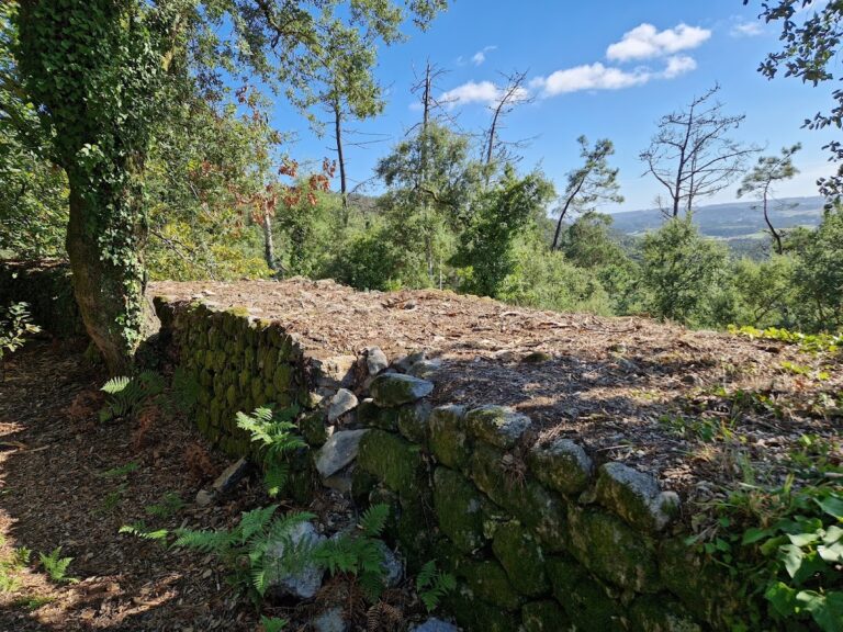
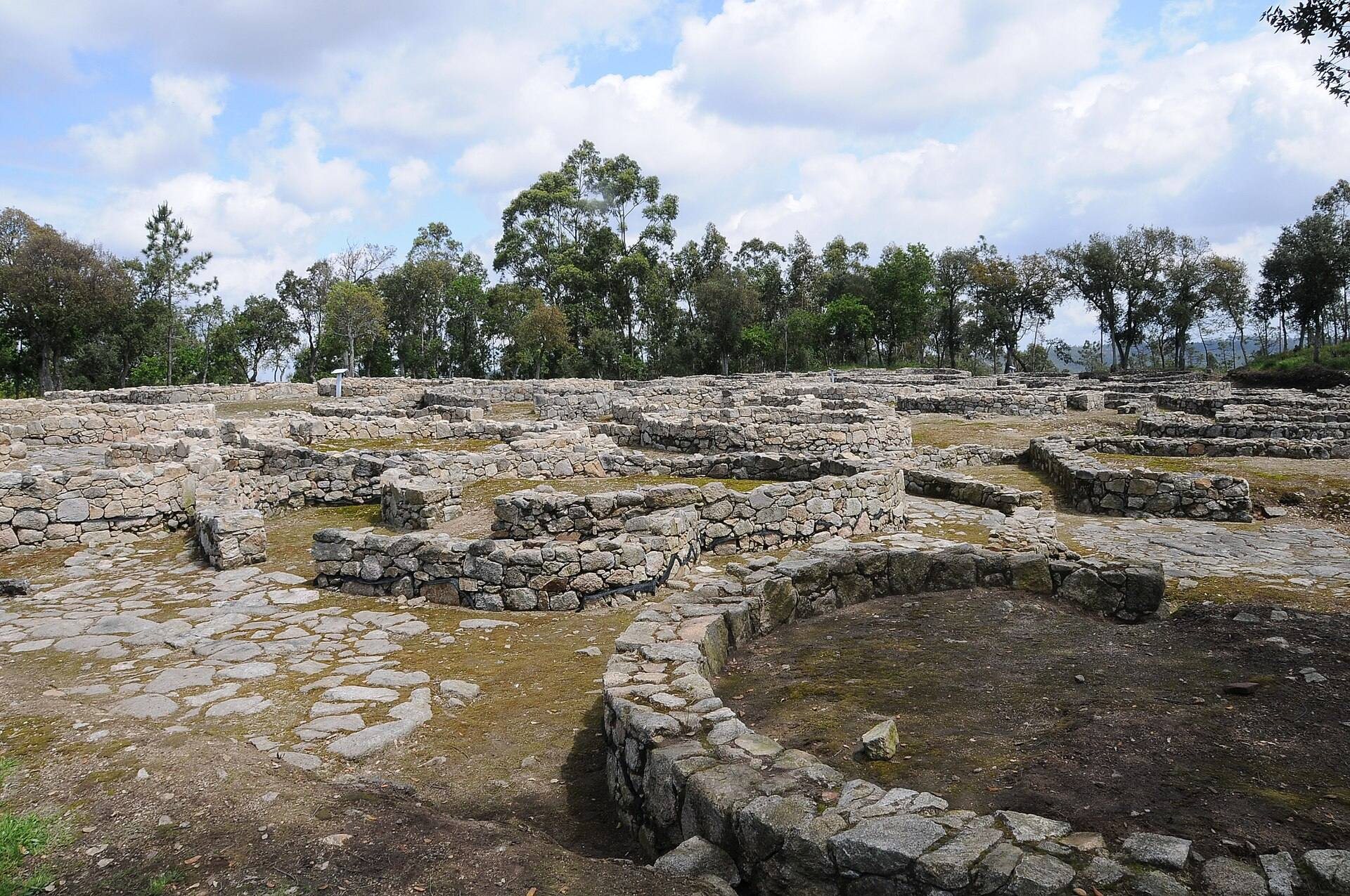
The settlement occupied the summit of Cividade Hill, with an acropolis, the fortified or elevated central part of a settlement, enclosed by three rings of walls built in successive stages. At its greatest extent, the acropolis covered about 12 hectares and held several hundred inhabitants. The defenses used large unmortared stone blocks adjusted to the hill’s topography. High, wide, resistant walls protected the more accessible southern, eastern, and western sides, while the steep slopes relied more heavily on the natural terrain.
The eastern defenses reached approximately 5.30 m in thickness. On the northeast, natural granite formed part of the wall and was topped by masonry. An entrance through the defensive perimeter was paved with slabs and measured approximately 1.70 m wide. A ditch about 1 m deep and 1 m wide may have surrounded the base of the hill. The site also contained residential compounds, paved courtyards, funerary enclosures, public spaces, narrow streets, channels, and possible sewers.
Urban Plan and Streets
The settlement had an organized plan divided into four sectors by two principal streets. Each sector contained approximately four or five family compounds. The Decumanus, an east-west Roman-planned street, ran broadly along the eastern wall before curving slightly southwest at its junction with the Cardo, the principal north-south street. It continued toward the citadel entrance, while the external approach descended gradually toward the route still used to reach the settlement. Narrow channels in parts of the site may have carried away rainwater.
Domestic Architecture
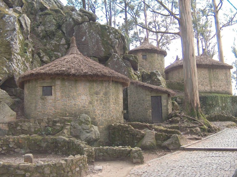
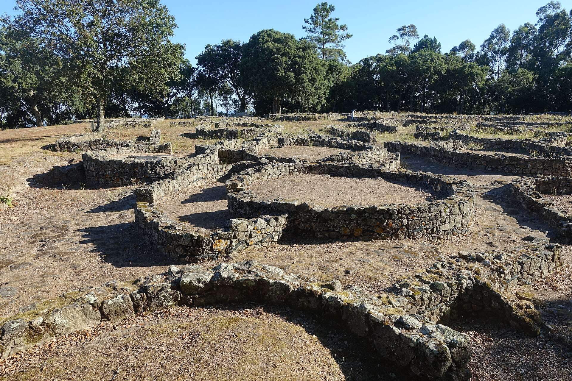
Family compounds generally contained four or five circular rooms arranged around a paved courtyard. Doorways opened toward the courtyard, where daily domestic activities took place, and the compounds could be locked. Some houses also had a forecourt. The earliest houses, dating from the eighth or ninth century to the fifth century BC, used vegetal materials mixed with adobe or clay. From the fifth century BC, stone construction became established with the use of iron picks.
Pre-Roman houses were usually circular, with diameters of approximately 4 to 5 m and walls 30 to 40 cm thick. Granite was fractured or split and laid in two courses, with smoother faces turned inward and outward. Small stones and coarse sand mortar filled the space between the courses. Floors were made from fine clay or coarse sand, and some areas around fireplaces carried cord-impressed, wavy, and circular motifs.
Roman reorganization introduced quadrangular buildings in place of the characteristic circular houses. Roofs used tegulae, flat Roman roof tiles, instead of vegetal materials and adobe. Walls retained the two-course construction but became 45 to 60 cm thick, with broader cores filled with coarse sand or clay and small- to medium-sized stones. Floors in the Roman-influenced phase became denser, thicker, and more carefully finished.
Craft Production and Exchange
A workshop near the southwestern entrance contained evidence of high-temperature fires, ores, metal droplets, casting slag, and other signs of metalworking. Large quantities of slag, fibulae, fragments of iron objects, and remains of lead, copper or bronze, tin, and possibly gold occur across the settlement. Fibulae were brooches used to fasten clothing. Copper and copper-alloy work included ceramic-repair clamps, pins, fibulae, styli, and needles, while iron objects included nails, hooks, and a point interpreted as part of either a sickle or a dagger.
Pottery included cups, vessels with stamped and impressed decoration, and pieces ornamented with incised designs or applied clay cords. The motifs included S-shaped forms interpreted as palmipedes, together with circles, triangles, semicircles, lines, and zigzags. Approximately two hundred decorative forms were identified. Loom weights, spindle whorls, and shears indicate textile production, including weaving and the systematic keeping of sheep for wool.
A shell midden, an archaeological deposit of discarded shellfish remains, contained limpets, mussels, and sea urchins. Hooks and net weights show that inhabitants could catch relatively large fish, although the evidence points to fishing as one activity among several rather than necessarily a regular pursuit. Amphorae and glass became common during Romanization and were used for transporting and storing cereals, fruit, wine, and olive oil.
Funerary and Religious Features
The Castro population cremated its dead and placed the ashes in small circular pits lined with stone. Early burials lay inside houses, while later ashes were placed outside the houses but within family compounds. A funerary cist, a stone-lined burial container, a complete bell-shaped vessel, fragments of another vessel without its cover, and additional stone-lined ash pits illustrate these practices. Some vessels show evidence of breakage or disturbance. Several pentagonal pits set into paved surfaces may have had a magical or religious function, although their exact purpose remains uncertain.
A small archaeological museum stands at the entrance to the settlement and supports interpretation of the remains. The most important excavated artifacts are housed in the Ethnography and History Museum of Póvoa de Varzim.