Zerzevan Castle: An Eastern Roman Frontier Fortress in Turkey


Site at a Glance
- Rating
- 4.7
- Popularity
- Low
- Country
- Turkey
- Primary era
- Classical
- Eras represented
- Classical, Medieval
- Civilizations
- Byzantine, Roman
- Site type
- Military
- Remains
- Fortified Town
On this page22 sections
History
Zerzevan Castle is a ruined Eastern Roman fortress in Turkey, built in the fourth century on the ancient route between Amida, now Diyarbakır, and Dara, now Mardin. The Eastern Roman Empire, often called the Byzantine Empire, was the Roman state centered in the eastern Mediterranean and Near East after the empire’s political division. Zerzevan served as a strategic garrison controlling movement along the route and across the surrounding valley.
Earlier settlement and frontier position
The precise date of settlement before the fortress is uncertain. The site has been proposed as the location of Kinabu, a fortress associated with the Assyrian period, around 882–611 BC. It may also have helped protect traffic on the Royal Road during the Persian period, around 550–331 BC. These earlier possibilities place Zerzevan within a landscape that had long connected different political regions.
In the Eastern Roman period, the settlement stood on the empire’s eastern frontier, where it witnessed conflicts between the Byzantine and Sasanian empires. Its garrison included military personnel and civilians. Jewelry found at the site has been interpreted as evidence that soldiers lived there with their families, and the settlement was large enough to accommodate about 1,000 people. The fortress therefore served not only as a defensive position but also as a settled community.
Eastern Roman rebuilding
Major repairs and rebuilding took place during the reigns of Anastasius I, who ruled from 491 to 518, and Justinian I, who ruled from 527 to 565. Both emperors strengthened frontier installations, while Justinian was especially associated with extensive imperial construction and reconstruction. Work carried out under these rulers brought Zerzevan to its final major form.
The fortress probably remained in use until about AD 639, when Arab Muslim forces appeared in the region during the opening phase of the Arab–Byzantine wars. Its geopolitical importance then declined. The elevated location, combined with difficulties in obtaining water and transporting supplies, contributed to the settlement’s abandonment. Temporary shelters continued to be used at the site until the 1890s.
Later settlement and changing names
A civilian settlement returned within the fortress in the 1890s. It began with one family and eventually grew to more than 30 households. In 1967, residents left because of water shortages and difficult access. They moved about 1 km away and founded Zerzevan village, now called Demirölçek.
The place-name appears in eighteenth-century travel accounts as “Kasr Zerzaua.” The Ottoman traveler Evliya Çelebi referred to a “Zerzivan Valley” in the fourth volume of his seventeenth-century travel work. The modern name is probably a transformed form of Zerzaua and may derive from Kurdish words for gold and silver, giving it the possible meaning “castle of gold and silver.”
Archaeology and heritage
Professional archaeological excavation began in the summer of 2014 with permission from Turkey’s Ministry of Culture and Tourism. The work has continued through cooperation between the ministry and Dicle University, under the direction of archaeologist Aytaç Coşkun and with oversight from the Diyarbakır Archaeological Museum. The initial team of 35 people expanded to about 60 in 2015.
Excavations have revealed extensive underground structures, including a Mithraeum, an underground Christian place of worship, secret passages, and a shelter. A Mithraeum was an enclosed sanctuary of Mithraism, a Roman mystery religion centered on Mithras and associated with restricted initiation rites. The fortress’s principal entrance was located in 2020, while excavations in 2021 recovered a six-holed flute and a bronze ring probably used with a chest key. Both objects date to the fourth or fifth century.
Zerzevan Castle and its Mithraeum are included on UNESCO’s World Heritage Tentative List. The listing recognizes the site’s Roman frontier-garrison character, its combination of surface and underground remains, the interaction of cultural and religious traditions, and the unusually well-preserved Mithraic sanctuary.
Remains
Fortifications and settlement layout
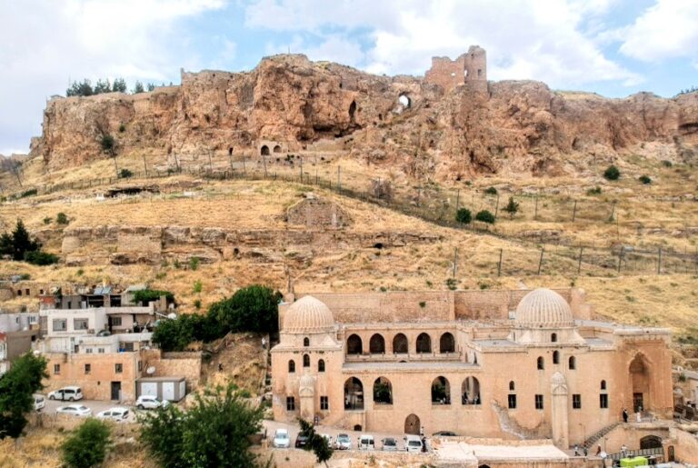
The fortified settlement covers approximately 5.7 hectares on a rocky hill at an elevation of 105–124 m. Its remains extend across both the surface and the underground spaces, while a rocky necropolis lies outside the settlement. Terrain and function divided the site into distinct areas. Residential buildings and streets occupied the lower northern zone, while public buildings were concentrated on higher ground to the south.
Defensive walls and entrance
The surviving defensive walls run for approximately 1.2 km. They generally stand about 12–15 m high and measure about 2.1–3.2 m in thickness. Ten regularly spaced bastions, projecting fortifications that strengthen a defensive wall, and two towers have been identified, together with projecting support walls between the bastions. One watchtower reaches approximately 21–22 m in height. The principal entrance, discovered in 2020, is approximately 1,800 years old.
Public and residential areas
The southern sector contained watch and defense towers, churches, an administrative building, an arsenal, and a rock altar. Residential buildings occupied the northern zone, where streets can still be traced. Some houses have a single room, while others contain several rooms. Their foundations were cut into the bedrock, and blocks produced by cutting the rock were used in their walls. Larger residential structures also occur in the southern part of the settlement.
Public buildings and water supply
Church
The church stands at the highest point of the settlement and follows an east–west orientation. It is divided into four sections and contains a baptismal basin. The building is among the best-preserved public structures at Zerzevan.
Arsenal
North of the church, the arsenal is the largest structure in that area. It has a narrow, elongated plan divided into two parts and measures approximately 10.9 by 36.4 m. Its form and position have led to its interpretation as a weapons store.
Rock altar and offering basins
A rock altar lies 19 m south of the church and measures approximately 7.7 by 10.2 m. Niches are set into its walls, and the structure is thought to have been used for offerings. Offering basins outside the walls are also thought to have served religious ceremonies during the Roman period.
Cisterns and channel
Fifty-four cisterns cut into the bedrock supplied water to the settlement. A cistern is a reservoir designed to collect and store water. A channel outside the southern fortifications supplied the cisterns, and approximately 616 m of it has been exposed by excavation.
Underground structures
Underground church
At the center of the settlement, an underground church was converted from Roman-period rock-cut tombs and used by the first Christians living at Zerzevan. A baptismal basin lies outside the structure. A niche for an oil lamp indicates that the space could be illuminated and used in the evening. Excavations in 2016 revealed the church along with secret passages. The church had probably been closed for approximately 1,500 years.
Underground shelter
An underground shelter near the northern fortification wall could accommodate approximately 400 people. Five ventilation openings provided air, and the entrance included a spiral staircase. The structure may have served as a refuge during wartime and as a food store in peacetime.
Secret passages
Excavations in 2016 revealed secret passages beneath the settlement. One passage had apparently remained unused for about 3,000 years. Four additional underground spaces were identified in 2017 and require further investigation.
Mithraeum
The Mithraeum is an underground sanctuary of Mithraism cut entirely into the bedrock. It measures approximately 7 m long, 5 m wide, and 2.5 m high, covering about 35 m². Its eastern wall contains rock-cut columns, a large central niche, and two smaller niches beside it. A flame-shaped crown, a symbol associated with Mithraism, is carved on the same wall, while a small basin is cut into the floor before the left-hand niche. Inscriptions and symbols at the entrance indicate the structure’s ritual function.
Burial area and excavated objects
Necropolis
Outside the settlement, the rocky necropolis, or organized burial area, contains three identified grave types. These are rock-cut graves with benches, vaulted graves, and sarcophagus-shaped graves cut into the rock.
Finds
Excavations have recovered military and medical instruments, jewelry, decorative objects, and bronze coins. The six-holed flute and bronze ring found in 2021 belong to the fourth or fifth century. Jewelry from the settlement contributes to the interpretation of Zerzevan as a community where military personnel and civilians lived together.