Welzheim East Roman Fort: A Roman Frontier Garrison in Germany
Site at a Glance
- Popularity
- Medium
- Country
- Germany
- Primary era
- Classical
- Eras represented
- Classical
- Civilizations
- Roman
- Site type
- Military
- Remains
- Fort
On this page21 sections
History
The Romans built Welzheim East Roman Fort in Germany as part of the Upper German-Raetian Limes, the Roman Empire’s frontier system. Occupied from about AD 159/160 to AD 259/260, it stood roughly 530 metres from the larger West Fort. A road and settlement linked the two installations, an unusual pairing on the frontier.
Garrison and frontier service
The fort housed a numerus, a Roman auxiliary military unit estimated at 150 to 200 men. Finds have also prompted a proposal that construction began earlier, perhaps a generation before the West Fort. The suggestion rests particularly on the quantity of red-surfaced Samian tableware recovered at Welzheim.
The garrison included Britons and scouts, known in Latin as exploratores. Brick stamps identify a unit called the Numerus Brittonum, although an additional abbreviated part of its title cannot be reliably expanded. One form of the name indicates that the unit was stationed at the fort from AD 159/161.
Fire, rebuilding and the end of the fort
The defences and buildings developed in two main phases. The first included the ditches, walls, gates and interior structures. A layer of burning dated to about AD 170/175 may be connected with the Marcomannic Wars, conflicts between Rome and Germanic groups during the second century. After the destruction, the fort was rebuilt with corner and intermediate towers; towers at the gates may also have been added.
The fort ceased to serve as a military installation when the Limes frontier broke down around AD 260. The civilian settlement around the forts, called a vicus, lay between them and extended south of the West Fort. This wider community formed part of the setting for the garrison, but later buildings have limited investigation of its full extent.
Investigation and preservation
Konrad Miller investigated the fort in 1886, followed by Adolf Mettler of the Imperial Limes Commission in 1894. When development threatened the site from 1960, archaeological heritage official Hartwig Zürn led efforts with research institutions and the Saalburg Museum to secure the land for preservation.
In 1976, the excavation plan shifted away from exposing the entire fort and concentrated chiefly on its defences. Excavations ended in 1981, and ground surveys followed in the early 1990s. A redesign in 1993 established the Archaeological Park East Fort, with casts of inscriptions from Welzheim and stones from across the Upper Germanic region. Since 2005, the Welzheim forts and associated remains have belonged to the UNESCO World Heritage property of the Upper German-Raetian Limes. They are also protected as cultural monuments under Baden-Württemberg heritage law.
Remains
The fort occupied a high plateau above the Lein, on a spur that slopes away to the south, east and north. At about 490 metres above sea level, the position gave the garrison a wide view and lay just beyond the Limes, outside Roman imperial territory. Within the fort, the ground falls about 10 metres from northwest to southeast. The stone enclosure measured approximately 123 by 126 metres, covering 1.6 hectares. Most of its remains survive below ground in an archaeological reserve and open-air park, where surface lines mark the restored perimeter and the plans of stone buildings.
Defences and entrances
Walls, ditches and walkway
A wall 1.1 to 1.4 metres thick enclosed the fort, with a double V-shaped ditch outside it. Both were interrupted at the four entrances. The sloping ground drained poorly, probably contributing to repeated wall collapses. Six small masonry channels built into the southwest foundations carried water away. On the southern side, the wall also supported an inner terrace about half a metre above the ground outside. Large postholes beyond the wall mark scaffolding used for repairs, while a row of postholes along its inner face indicates a timber walkway.
Gates and towers
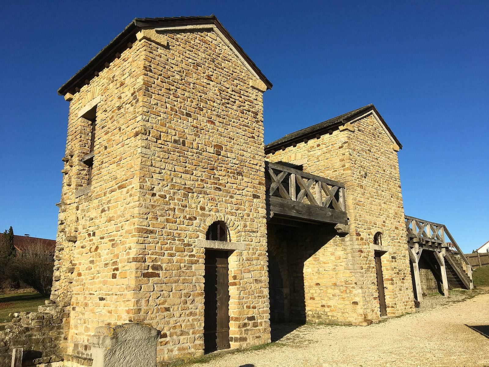
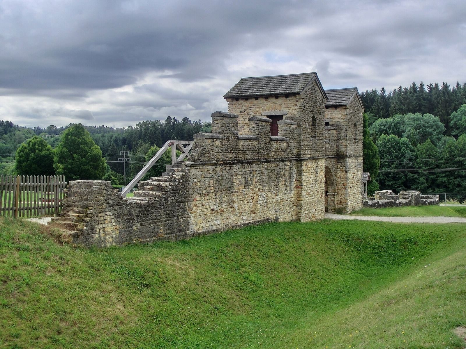
The South and North Gates each had a single-lane passage and one inward-projecting wing wall. Original paving survived in their passages. The single-lane East Gate had a tower on its north side and a wing wall to the south. The reconstructed West Gate has two towers, each measuring 3.8 by 4 metres, flanking a passage 3.6 metres wide; repairs were also identified there. Projecting wing walls at the south, north and east entrances probably belonged to the first defensive phase. After the fire and rebuilding, four corner towers and intermediate towers were added. Intermediate examples were found along the west and western north sides, while gate towers may also have been built.
Buildings and roads within the fort
Roads and timber structures
A road ran around the inside of the defences, measuring 3.3 metres wide in one excavated area. Two timber buildings were uncovered beside it in 1977. Ground surveys also indicate that the fort probably had a headquarters building, although its position and orientation remain uncertain.
Bath and possible granary
A stone building in the southeast quarter has been identified as a bath. It stood within an area divided by two intersecting roads. Its unusual position and size have led to the suggestion that it was built after the fort’s military use ended, but its date is uncertain.
In the western part of the fort, beside the east-west road, stood a rectangular stone building about 14 metres long. Charred grain found there supports its tentative identification as a granary. Its excavated plan is now marked by masonry lines at ground level.
Wells and their contents
Well 2
Four timber-lined wells were excavated in the area of a camp road. The older, Well 2, was completed about AD 165 and abandoned before Well 1 was installed. Its interlocking timber lining measured 1.5 by 1.5 metres and extended into a surviving well chamber. After it stopped supplying water, the well was used as a refuse pit. Its light-brown, clay-rich fill differed from the darker fill in Well 1.
Well 2 contained a wooden shovel, a broken yoke, a copper bucket and substantial remains of an iron cavalry face mask. The mask, 25 centimetres high, is of the Alexander type, associated with the Macedonian king Alexander the Great. Such masks were used chiefly for cavalry parades and displays rather than ordinary combat. It dates to the second or third century and was restored at the Roman-Germanic Central Museum. The well also held three portable defensive stakes, used to protect temporary camps, each as long as 1.84 metres.
Well 1
Well 1 was built around AD 190, with an estimated margin of ten years, beside the fort’s southwest corner tower. Its timber lining was joined with mortise joints, fitted cuts that lock wooden pieces together, and survived in excellent condition from about two metres below the surface. The well was abandoned and filled between about AD 230 and 250.
Its fill included about 100 leather shoes, ranging from very small children’s shoes to boots, most of them worn. Other finds included a writing tablet, pottery, tools, everyday objects, seeds, fruit remains and large quantities of wood. Some wooden items were made from imported cedar and cypress.
Food, plants and woodland
Plant remains from Well 1 show a varied supply of food. They included imported figs, grapes and plums, alongside wild strawberries, raspberries, blackberries, rose hips, blueberries, apples, hazelnuts and walnuts. Vegetables and salad plants included lamb’s lettuce, carrots, parsnips, green amaranth, Roman sorrel and orache. Field beans, lentils, peas, coriander, dill, thyme and celery were also present, along with medicinal plants, grains, flax and poppy. The poppy was at an early stage of domestication. Locally gathered forest berries were more prominent than other fruit.
More than 60 types of grassland plant point to cut vegetation gathered from productive meadows and stream valleys. These cuttings were probably used as animal fodder and bedding, respectively. Wood from 19 native tree species was identified, especially beech, oak, hazel, maple and fir. The mix suggests that beech, oak and fir forests with varied undergrowth grew around ancient Welzheim. Oak and fir made up more than 80 per cent of the wood selected for buildings and tools, while beech accounted for about 14 per cent. The later material may reflect a greater share of beech and a decline in forest quality, perhaps through Roman timber extraction, although differences in juniper remains complicate that interpretation.
Inscriptions and pottery
Altar and inscribed table
An inscribed stone altar was found in 1894 among rubble from the bath’s heating installation, where it had probably been reused as building material. It dedicates an offering to Jupiter Optimus Maximus, the chief Roman god, for the emperors’ welfare. The inscription, dated AD 198 to 211, names Marcus Octavius Severus, a centurion of the Eighth Legion Augusta, and identifies him as commander of the Britons and scouts.
A fragment of a circular table top made from regional sandstone was found in 1897 in the headquarters building. Two lines ran around its upper surface, with further writing around the edge; only portions of the text survive. The fragment is held by the Württemberg State Museum in Stuttgart.
Samian tableware
More than 250 additional pieces of Samian ware and stamped pottery were recovered from the fort, approximately doubling the previously known assemblage. Samian ware was fine Roman tableware with a red surface, often decorated with moulded reliefs.
Settlement, burials and wells beyond the fort
Buildings, cemetery and tile kiln
Excavations northwest of the East Fort between 1955 and 1964 revealed settlement traces, including timber and stone buildings. About 100 metres west of the fort’s northwest corner, earlier burial traces were followed in 1979 by excavation of 162 cremation burials dating to the second and third centuries. A Roman tile kiln was excavated south of the fort in Tannwald.
Wells in the southern settlement
Two oak-lined wells in the southern part of the vicus were excavated in 2011. Their persistently wet conditions preserved bronze objects, mostly military equipment. One well contained a round medallion about 22 centimetres across, with a raised bust of Minerva. It belonged to horse parade equipment and was attached to the animal’s chest by a central strap distributor. Associated objects included a complete parade greave, or lower-leg armour, with a knee boss, and a bronze plate.
The other well held an unusually large, exceptionally well-preserved bucket made from thin bronze sheet, probably used by a wealthy resident to mix wine. The bronze objects may have been deposited during unrest around the Limes’ collapse in about AD 260. Finds from Welzheim are held by the Welzheim Municipal Museum, the Württemberg State Museum and the Limes Museum in Aalen.