Walls of Constantinople: The Defenses of a Byzantine Capital
Site at a Glance
- Country
- Turkey
- Primary era
- Medieval
- Eras represented
- Classical, Medieval, Early Modern
- Civilizations
- Byzantine, Ottoman, Roman
- Site type
- Military
- Remains
- Wall
On this page21 sections
History
The Walls of Constantinople are a succession of land and sea defenses around the historic city, in present-day Istanbul, Turkey. Roman and Byzantine rulers began building them in the fourth century, when Constantine I established the city as a new imperial capital, and expanded and repaired them over many centuries. Together, the defenses protected the city against attacks from both land and water.
From Byzantium to Constantine’s new capital
Tradition traces Byzantium’s foundation to Greek colonists from Megara, led by Byzas, in the seventh century BC. A small early wall is also attributed to Byzas, although it may have been built after the Spartan general Pausanias captured and rebuilt the settlement in 479 BC. In 340 BC, during a threat from Philip II of Macedon, a leader named Leo repaired the wall using tombstones.
Byzantium supported Pescennius Niger in his struggle against the Roman emperor Septimius Severus. Severus besieged the city until 196, tore down its walls, withdrew its civic status, and reduced it to a dependent village. He later rebuilt it, recognizing its strategic value, and placed a new wall about 300 to 400 metres west of the earlier circuit.
During Constantine I’s conflict with Licinius in 324, a defensive wall near Philadelphion was noted beyond Severus’s circuit. Constantine rebuilt the city between 324 and 336 and inaugurated it on 11 May 330 as New Rome, also called Second Rome. It became known as Constantinople, meaning the City of Constantine. His successor Constantius II completed the new city wall.
The Theodosian land defenses
By the early fifth century, the expanding city had spread beyond Constantine’s wall into the district called Exokionion. The Theodosian Walls became its principal land defense. Work on their first phase began around 404 or 405, during the reign of Arcadius, under Anthemius, a senior imperial official. The wall was completed in 413.
Earthquakes in 437 and 447 damaged both the Constantinian and Theodosian defenses. The 447 shock brought down extensive stretches of wall and 57 towers, while another earthquake in January 448 added to the destruction. With Attila’s forces threatening the Balkans, Theodosius II assigned the prefect Constantine to direct urgent repairs. Constantine enlisted the city’s chariot-racing factions, and the damaged defenses were restored in 60 days. The outer wall and moat may have been added during this emergency, though they could also have belonged to the original plan.
Earthquakes and flooding from the Lycus repeatedly harmed the walls. A city official responsible for their upkeep organized repairs using the labor of Constantinople’s inhabitants. Inscriptions commemorated emperors and officials associated with restoration. The defenses withstood the Avar-Persian siege of 626, Arab sieges, attacks by Rus’ and Bulgars, and other assaults. Even after siege artillery appeared, early cannon could not damage the walls quickly enough to stop defenders from repairing them between shots.
Sea defenses and medieval repairs
The early history of the sea walls is uncertain. They are traditionally attributed to Constantine, but the first dated construction work came in 439, when urban prefect Cyrus of Panopolis was ordered to repair the city walls and complete the seaward defenses. The order followed the Vandal capture of Carthage and a growing naval threat in the Mediterranean. The defenses were repaired in the early eighth century, under either Tiberius III or Anastasios II. Michael II began a major rebuilding, completed by Theophilos, who raised the walls. Many inscriptions associated with the sea defenses carried Theophilos’s name.
Venetian forces breached the sea walls in 1203 and 1204 during the Fourth Crusade, exposing their vulnerability. After Byzantine rule returned in 1261, Michael VIII Palaiologos strengthened and raised the defenses in response to possible attack by the Latins and the Genoese settlement across the Golden Horn at Galata. Later repairs followed storms and military threats. Andronikos III repaired breaches caused by a storm on 12 February 1332; John VI Kantakouzenos repaired the Golden Horn defenses and added a moat in 1351, during war with Genoa. Further work took place in 1434 and before the 1453 siege, with part of the latter effort financed by Serbian ruler George Brankovic.
The Golden Horn frontage also bordered commercial and residential districts. Muslim merchants had a designated quarter with a mosque, while Italian maritime republics received trading quarters with waterfront wharves from the reign of Alexios I Komnenos onward. Along the Sea of Marmara, strong coastal currents made a fleet attack more difficult, but the defenses still had to protect the city against the sea itself. Emperors John II and Manuel I Komnenos returned in triumph through the Eastern Gate in 1126 and 1168. Manuel also planned a chain across the Bosphorus, although it was probably never installed.
Sieges, conquest, and Ottoman rule
After the Latin conquest of Constantinople in 1204, maintenance declined. The Byzantine state restored in 1261 lacked the means for comprehensive upkeep, except when immediate danger demanded repairs. During the siege of 1422, defenders concentrated their forces on the outer land wall because they did not have enough troops to man both defensive lines.
The final Ottoman siege lasted about six to seven weeks. The defenders endured assaults, mining, and artillery before the city fell on 29 May 1453. The Genoese commander Giovanni Giustiniani was wounded and withdrew, a retreat that contributed to panic among the defenders. Ottoman numerical superiority and maneuvering also played a part; the walls continued to function as a defense during the siege. The exact point of the decisive entry is disputed. The Fifth Military Gate is associated with the breach, while the final assault has also been linked to the Gate of St. Romanus or the allegedly open Kerkoporta. Mehmed II entered through the Gate of Charisius and soon ordered repairs. The walls continued to be maintained under Ottoman rule.
Earlier episodes also shaped the gates’ history. In 1261, troops of the Empire of Nicaea retook the city from the Latins through the Gate of the Spring. During the final siege, Constantine XI Palaiologos commanded near the Gate of Charisius. Tradition places his death near the Gate of St. Romanus, but that attribution is uncertain.
Changes to the walls and modern conservation
As the city expanded beyond its medieval limits in the nineteenth century, sections of the defenses were dismantled. Railway construction removed much of the Golden Horn wall in the 1870s. The short wall and Wooden Gate where the land and sea defenses met were demolished in 1868. Construction of the Kennedy coastal road damaged portions of the Propontis wall in 1956 and 1957.
Large-scale restoration of the land walls began in the 1980s. Some interventions were criticized for unsuitable materials, an emphasis on surface reconstruction, and damage to historical evidence. During the 1999 earthquake, restored sections collapsed while older masonry beneath them remained intact. In 2008, the World Monuments Fund placed the walls on its Watch List of the world’s 100 most endangered sites, citing urban pollution and inadequate restoration among the threats. The walls form part of the Historic Areas of Istanbul, designated a UNESCO World Heritage cultural site in 1985.
Remains
The surviving defenses belong to several connected systems rather than one uninterrupted wall. They include the successive circuits of Byzantium, Severus, and Constantine; the Theodosian land defenses; the walls of Blachernae; and the sea walls along the Golden Horn and the Propontis, the historical name for the Sea of Marmara. Limestone and brick were used across the system, whose form and height adapted to the city’s changing terrain and shoreline.
Early land circuits
Byzantium and the Severan circuit
The earliest reported wall enclosed the small settlement around its acropolis on the easternmost hill. It had 27 towers, at least two gates on the landward side, and a lower wall toward the sea. The Arch of Urbicius and a gate near the later site of the Milion are identified with its entrances. Severus’s replacement stood about 300 to 400 metres farther west. Its principal gate opened at the end of a colonnaded avenue near the later Forum of Constantine. The wall’s reconstructed course runs from near the modern Galata Bridge, south past Nuruosmaniye Mosque and around the south side of the Hippodrome, then northeast toward the Bosphorus.
Constantine’s circuit
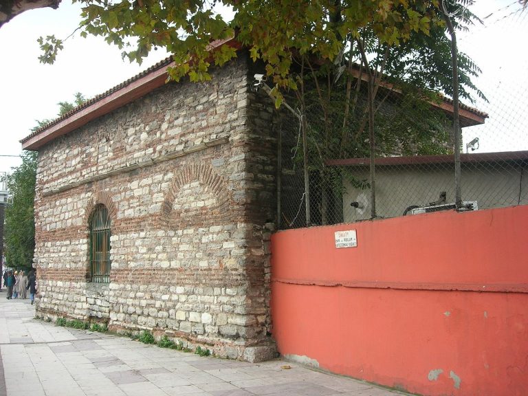
Constantine’s wall stood about 2.8 kilometres west of the Severan line. It was a single wall with 324 towers. Its course began near the Church of St. Anthony on the Golden Horn, ran southwest past the Mocius and Aspar cisterns, and ended near the Church of the Theotokos of Rhabdos on the Propontis. The route is only partly known. Five gates have been associated with the circuit, but their identities and locations remain disputed. The Old Golden Gate, also called the Xerolophos or Gate of Saturninus, stood on the southern slope of the Seventh Hill. Later descriptions portray it as a tall opening of large marble blocks, topped by a colonnade-like structure. An earthquake destroyed it in 1509; the nearby İsakapı Mosque indicates its approximate location.
Theodosian land defenses
Alignment and inner wall
The Theodosian line extended about 5.7 kilometres between the Marble Tower on the Propontis and the area of the Palace of the Porphyrogenitus in Blachernae. Its outer wall and moat ended earlier, near the Gate of Adrianople. The wall followed the changing ground, rising from the Propontis to about 14 metres above sea level at the Golden Gate, reaching around 68 metres near the Gate of St. Romanus, dropping to 35 metres in the Lycus valley, and climbing to about 76 metres at the Gate of Charisius, also called the Gate of Adrianople, before descending toward Blachernae.
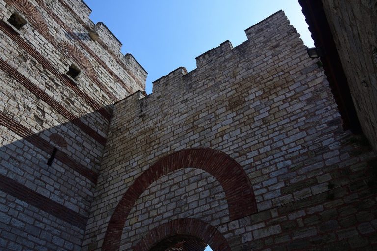
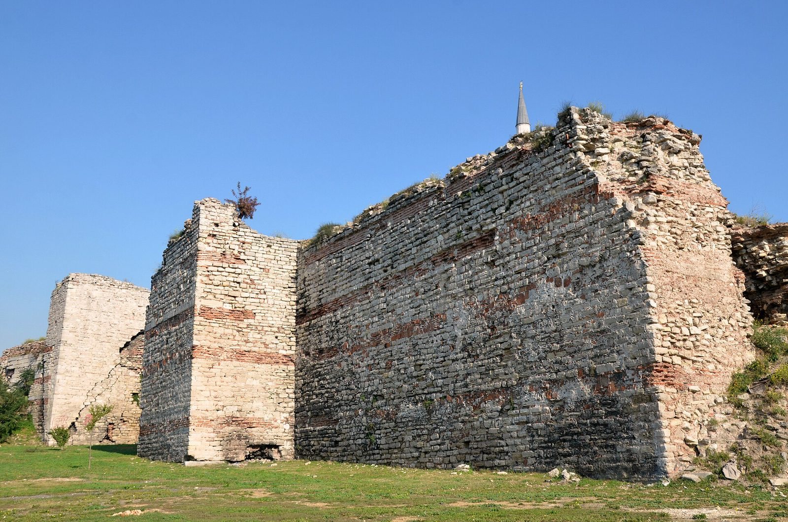
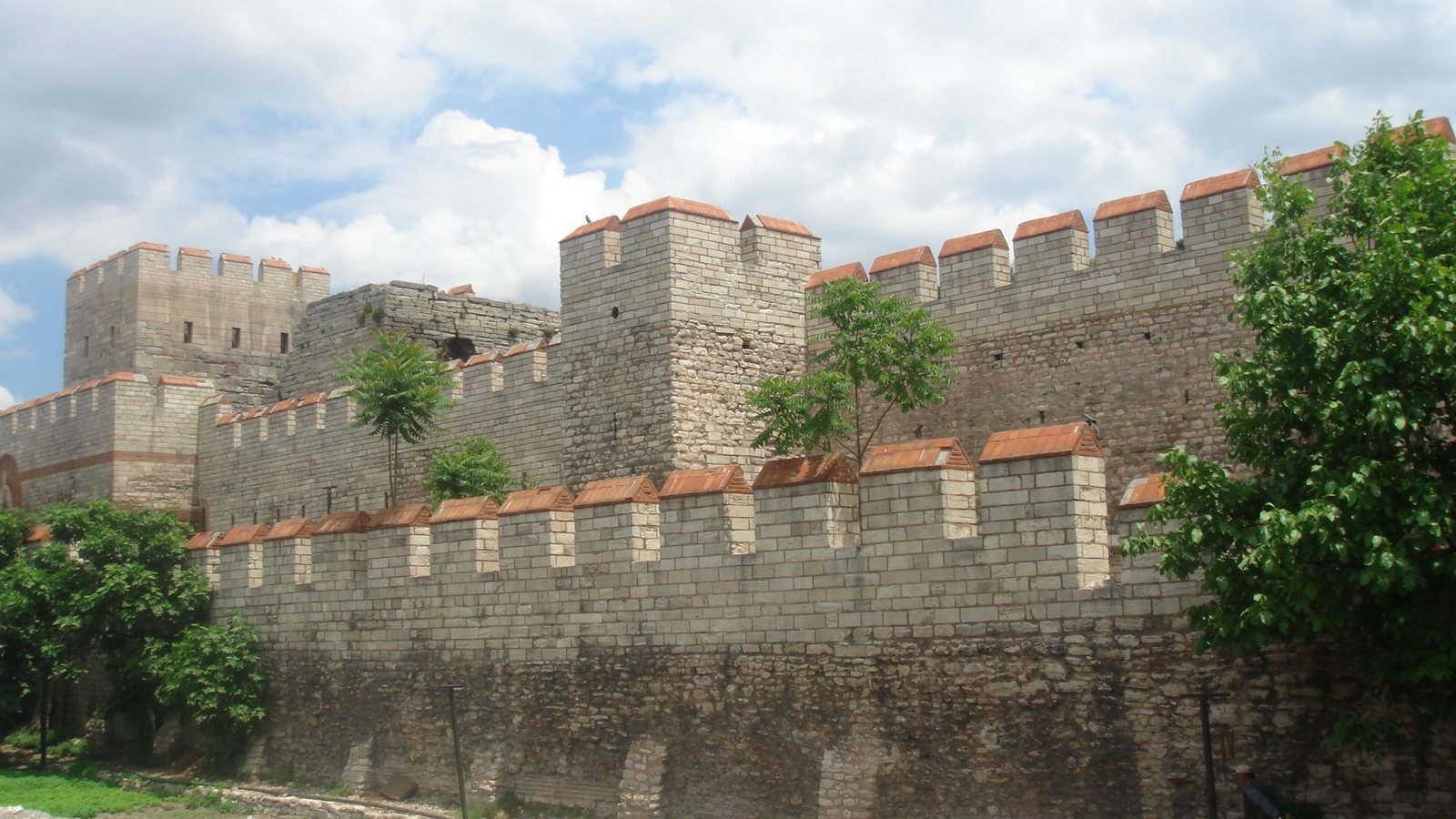
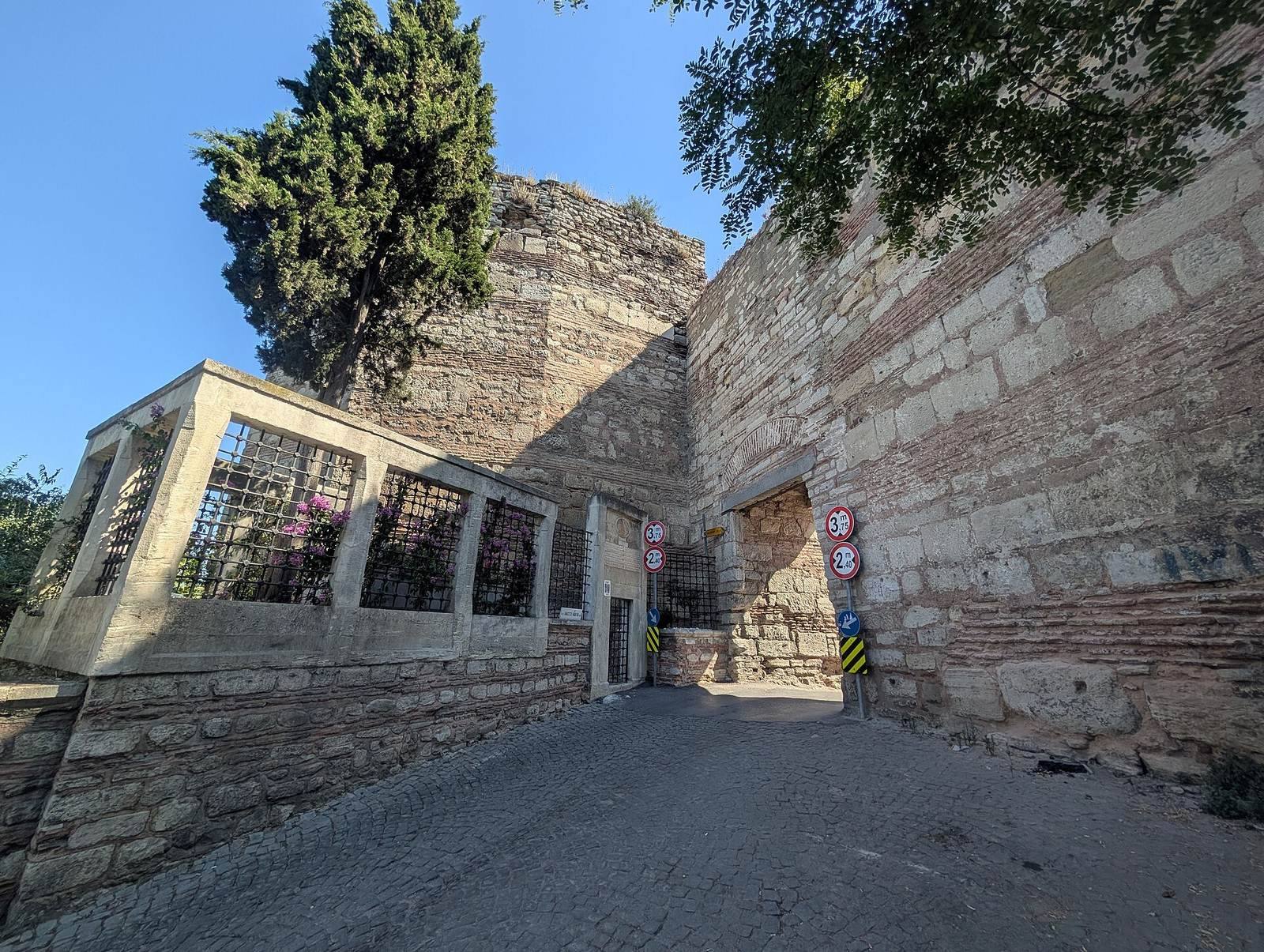
The main inner wall was 4.5 to 6 metres thick and about 12 metres high. Carefully cut limestone formed its face; lime mortar and crushed brick made up the core. Between seven and eleven bands of brick, each about 40 centimetres thick, ran through the masonry, joining the facing to the core and helping the structure withstand earthquakes. Its 96 towers were mostly square, with some octagonal examples, three hexagonal towers, and one pentagonal tower. They generally stood 15 to 20 metres high and measured roughly 10 to 12 metres across. Tower spacing varied with the terrain, usually falling between 40 and 60 metres.
Each inner-wall tower had a roof terrace with defensive notches and two chambers separated by a floor. The lower chamber opened toward the city and served as storage; the upper one, reached from the wall walk, had windows for observation and firing projectiles. Ramps from within the city gave access to the wall. Most surviving towers were rebuilt in Byzantine or Ottoman times, and only the foundations of some are original Theodosian work. Later rebuilding often retained the roof terrace but omitted upper windows and firing openings.
Outer wall, terraces, and moat
A lower outer wall stood beyond a defensive terrace between the two walls. It was about 2 metres thick at its base and 8.5 to 9 metres high. Arched chambers at terrace level supported a walkway with a notched parapet. Its towers generally stood midway between those of the inner wall, most often 50 to 66 metres apart. Sixty-two survive; most are square or crescent-shaped, about 12 to 14 metres high and 4 metres wide. Their upper chambers had windows, and their roofs formed defensive terraces. The lower parts were either solid or contained small secondary gates.
The moat lay about 20 metres beyond the outer wall. It exceeded 20 metres in width and reached up to 10 metres deep, with a 1.5-metre wall along its inner edge. Cross-walls within it narrowed toward the top, preventing their use as bridges. Some incorporated pipes bringing water from higher ground north and west of the city; these may have served as water channels, dams between moat sections, or both. The moat probably stopped near the Gate of St. Romanus, where the steep Lycus valley made construction difficult, and resumed beyond the Gate of Adrianople. The disputed Mesoteichion, or “middle wall,” was regarded as a weak stretch, but its exact limits are uncertain.
Gates and posterns
The land defenses had nine principal gates passing through both walls, along with smaller posterns, or secondary gates. The traditional division between public entrances and numbered military gates does not reliably describe how they were used. The Golden Gate, between the ninth and tenth towers of the inner wall, was a three-arched entrance built from large, polished white marble blocks without cement. Its central arch was larger than the two side arches, which remained open for ordinary traffic. Its construction date is disputed: it is usually assigned to Theodosius II and the Theodosian circuit, though another interpretation connects it to an earlier triumphal arch under Theodosius I. A now-lost Latin inscription referred to Theodosius and the defeat of a usurper.
Sculpture once decorated the Golden Gate. A statue of Theodosius I in a chariot drawn by elephants fell during the earthquake of 740, and a large cross fell in 561 or 562. A Victory statue was removed during Michael III’s reign, while a crowned figure of Fortune also adorned the entrance. In 965, Nikephoros II Phokas fitted it with bronze gates taken from Mopsuestia. A separate outer arch was decorated with reused marble reliefs, probably installed in the ninth or tenth century. Seventeenth-century descriptions mention mythological scenes, including the Labours of Hercules, arranged in two tiers. Most reliefs were later lost; fragments are held in the Istanbul Archaeological Museum.
The Golden Gate later became part of a fortified enclosure. John V Palaiologos added two towers and extended a wall about 350 metres toward the sea, forming a separate refuge within the city. Mehmed II’s Yedikule fortress incorporated four existing towers, the eighth through eleventh of the inner wall, and added three larger ones. The Golden Gate ceased to serve as an entrance. The fortress was used as a treasury, archive, and state prison before becoming a museum in 1895.
Other surviving or identified entrances include the Xylokerkos Gate, now Belgrat Kapısı, between towers 22 and 23. The gate complex is about 12 metres wide and nearly 20 metres high, with an opening about 5 metres across. Its name recalls a wooden circus outside the walls. The Gate of the Spring, now Silivri Kapısı, lies between heptagonal towers 35 and 36. Those towers were extensively rebuilt in the later Byzantine period; an inscription on the southern tower records repairs under John VIII Palaiologos in 1439. Its present arch dates to the Ottoman period, and an underground space containing fourth- or fifth-century reliefs and tombs was found beneath it in 1998.
The gate now called Yeni Mevlevihane Kapısı, between towers 50 and 51, is commonly identified with the Gate of Rhegion or Rhesios and retains much of its fifth-century appearance. The Gate of St. Romanus, now Topkapı, stands between towers 65 and 66; its gatehouse is about 26.5 metres high, second in size only to the Golden Gate. Its Turkish name, “Cannon Gate,” recalls an Ottoman cannon positioned opposite during the 1453 siege. The badly damaged Fifth Military Gate, north of the Lycus, shows extensive later repairs and is also called Sulukulekapı or Hücum Kapısı. Some scholars identify it, rather than Topkapı, as the Gate of St. Romanus. At the top of the Sixth Hill, about 77 metres above sea level, the Gate of Charisius is now Edirnekapı. It was an important city entrance; an identification with the Gate of Polyandrion or Myriandrion, near a cemetery outside the walls, has also been proposed.
The Xylokerkos Gate was reportedly closed by Isaac II Angelos in 1189 because of a prophecy that Frederick Barbarossa would enter the city through it. It reopened in 1346, was shut again before the 1453 siege, and remained closed until 1886. A small postern at the first tower where the land and sea walls meet has a Chi-Rho, an early Christian monogram for Christ, above its opening. In the late Ottoman period it was known as Tabak Kapı. The Kerkoporta is associated with a postern found in the outer wall near the Palace of the Porphyrogenitus, but a matching opening in the inner wall has not been established. Its identification remains uncertain.
Walls of Blachernae
Earlier enclosure and the Wall of Manuel Komnenos
The walls of Blachernae joined the Theodosian circuit near the Palace of the Porphyrogenitus to the sea defenses at the Golden Horn. Their separate sections generally stand 12 to 15 metres high, are thicker than the Theodosian walls, and have towers placed closer together. They follow a steep slope and generally have no moat. A short connecting wall with a postern links the Theodosian defenses near the palace to the first tower of the Wall of Manuel Komnenos.
An earlier wall probably dating to the fourth century enclosed the Blachernae district, which was separate from the rest of the city. Its route ran from the Palace of the Porphyrogenitus toward Anemas Prison and may have enclosed a triangular area that included the Church of St. Demetrios Kanabos. The older defenses were later incorporated into the wider circuit: the western side served as an outer defense, while the eastern side fell into disrepair. During the siege of 626, the Panagia Blachernitissa and St. Nicholas sanctuaries stood beyond the district’s defenses and were burned.
Manuel I Komnenos built his wall to protect the imperial residence at Blachernae. It is about 220 metres long and roughly 5 metres high, with unusually large masonry and a series of arches on its outer face. Eight towers are round or octagonal, and one is square. After the third tower, the wall turns sharply north. A postern lies between its second and third towers; the large Eğri Kapı, or Crooked Gate, stands between the sixth and seventh. The latter is often identified with the Byzantine Gate of Kaligaria, though the identification is not certain. The road curves around a tomb in front of it.
Walls near Anemas Prison
A wall about 150 metres long runs from the final tower of Manuel’s wall to Anemas Prison. Its four square towers and thinner masonry distinguish it from the heavier adjoining defenses. Inscriptions record repairs in 1188, 1317, and 1441. A blocked postern beyond the second tower is commonly identified as the Gate of Gyrolimne and is decorated with three imperial busts.
The Wall of Leo, the outer line beside Anemas Prison, was built by Leo V in 813 against the Bulgarian ruler Krum and extended south by Michael II. It is less than 3 metres thick, rests on arches, and has four towers and numerous narrow openings. Behind it, Theophilos strengthened an inner wall with three hexagonal towers. The two lines stand about 26 metres apart; a gate in each forms the Gate of Blachernae. The enclosed area was called the Bracelet of Blachernae and, after the Ottoman conquest, the Five Towers.
The inner wall is traditionally identified as the Wall of Heraclius, built after the Avar-Persian siege to protect the Church of Blachernitissa. Another interpretation associates it with the Pteron, meaning “wing,” attributed to Theodosius II. The location and identity of the Pteron remain disputed.
Sea walls and related defenses
Golden Horn wall and chain
The Golden Horn wall ran about 5.6 kilometres from the Cape of St. Demetrius to Blachernae. Set inland from the shore, it stood about 10 metres high. Most of it was removed in the 1870s for railway construction, though its route and the positions of most gates and towers are known. Cristoforo Buondelmonti described 14 gates and 110 towers, and sixteen gates of Byzantine origin are identified.
Among the known entrances were the Koiliomene Gate and Gate of St. Anastasia, the Balat Gate near the approach to Blachernae Palace, and the Phanarion and Petrion gates. Two Byzantine gates near Balat are identified as the Gate of the Hunter and the Gate of St. John the Forerunner and Baptist, though it is uncertain whether they were separate. The Phanarion Gate, now Fener Kapısı, marked the western entrance to Petrion Fort. That fort comprised two stretches of wall between the Phanarion and Petrion gates, with a smaller Gate of Diplophanarion in its inner line. Farther along the shore were entrances serving the trading quarters and harbors, including the Gate of the Neorion, now Bahçekapı, which led to the harbor and naval arsenal of ancient Byzantium.
A heavy chain across the Golden Horn’s entrance obstructed vessels entering the inlet. Installed under Leo III, it was supported by floating barrels and stretched between the Tower of Eugenius at Sirkeci and a square tower at Galata, whose basement later became the Yeraltı Mosque. The Gate of Eugenius, also called the Marble Gate, led to the Prosphorion harbor and stood near the fourth-century tower. The gate was faced with marble and carried a statue of Julian; it is generally identified with the demolished Yalıköşkü Kapısı.
Propontis wall
The Propontis wall followed the coast except where harbors and quays interrupted its line. It measured about 8,460 metres in length and stood 12 to 15 metres high, with 13 gates and 188 towers. Another 1,080 metres enclosed the inner side of the Vlanga harbor. A boulder breakwater protected the base, and marble shafts reinforced the foundations. The Eastern Gate, also called the Gate of St. Barbara or Top Kapısı, had two large white-marble towers, unlike most seaward entrances. Its marble was removed in 1816 for Sultan Mahmud II’s Marble Kiosk.
Other entrances served coastal districts, palaces, and harbors. The gate of Boukoleon Palace was called the Gate of the Lion after the marble lions beside it, and the Gate of the Bear after animal images at the quay; its present name is Çatladıkapı. The Gate of the Sophiae, also known as the Iron Gate, opened toward the harbor of Sophiae, while Kontoskalion led to a late Byzantine harbor. Yenikapı near the Eleutherius, or Theodosius, harbor bears a Latin inscription commemorating repairs after the earthquake of 447. Farther along the coast, the Gate of Psamathia, now Samatya Kapısı, served the district of the same name.
Defenses beyond the city walls
The city’s defenses formed part of a wider network. The Anastasian Wall, or Long Wall, was built in the mid-fifth century about 65 kilometres west of Constantinople. It ran for about 56 kilometres, measured 3.3 metres thick, and stood more than 5 metres high. It was abandoned in the seventh century as maintenance and garrison forces dwindled; sections remain. Across the Golden Horn, Galata’s defenses were linked to the city’s sea defenses and chain. After Galata became a Genoese colony, its circuit was expanded with walls and towers. Most were demolished in the 1870s, but the Galata Tower and fragments of the defenses survive.
Before the conquest of Constantinople, the Ottomans also built two fortresses at the Bosphorus’s narrowest point to control the waterway. Anadoluhisarı, built by Bayezid I in 1394, began as a roughly pentagonal watchtower about 25 metres high within a surrounding wall. Rumelihisarı, built by Mehmed II in 1452, has three large towers, a smaller tower, connecting walls, and thirteen small watchtowers. Its principal towers were equipped with cannon.