Tyras: An Ancient Greek and Roman Port City in Ukraine


Site at a Glance
- Rating
- 4.6
- Popularity
- Very Low
- Country
- Ukraine
- Primary era
- Medieval
- Eras represented
- Classical, Medieval, Early Modern
- Civilizations
- Ancient Greek, Genoese, Ottoman, Principality of Moldavia, Roman
- Site type
- City
On this page17 sections
History
Tyras was an ancient Greek and Roman port city in Ukraine, within modern Bilhorod-Dnistrovskyi on the high right bank of the Dniester Liman. Founded by colonists from Miletus, probably in the late sixth or early fifth century BC, it became an important settlement at the meeting point of Black Sea maritime routes and river communications leading north. Its history extends from Greek colonization through Roman rule and later medieval and Ottoman occupation.
Greek foundation and expansion
The location had been settled since the Late Paleolithic. Greek colonists from Miletus, an ancient city on the western coast of Asia Minor, established the polis, or city-state, of Tyras at the mouth of the Dniester. The precise foundation date is uncertain, although approximately 600 BC is also proposed. Ancient literary sources preserve the earlier name Ophiussa, while inscriptions and coins use Tyras from at least the fourth century BC.
The city’s position gave it access to both sea and inland exchange. Tyras traded with Greek, Roman, Getae, Scythian, Thracian, and other communities, linking the Black Sea and Mediterranean with the Dniester basin and routes extending northward toward the Baltic. Contacts with the Getae, a Thracian-speaking population of the lower Danube and northern Balkans, and with nomadic peoples of the region helped the settlement expand. By the third quarter of the fifth century BC, Tyras had become a major regional center.
An inscription recording financial contributions to the Delian League, the Athenian maritime alliance of Greek communities, lists Tyras as paying two talents in 425 to 424 BC. This confirms the city’s membership in the alliance and indicates that its contribution exceeded that of nearby Nikonion. Tyras reached an economic and cultural high point from the fourth to the first half of the third century BC. Agriculture, viticulture and wine production, animal husbandry, fishing, crafts, and long-distance trade supported its economy.
Its commercial connections extended to Thasos, Rhodes, Attica, Cyzicus, Sinope, Heraclea, Tomis, Callatis, Olbia, Chersonesos, the Bosporan cities, and Alexandria in Egypt. Tyras began minting its own money during the second half of the fourth century BC, producing silver and bronze coins as well as gold staters. Their imagery included Heracles, the river god Tyras, Demeter, Alexander, Athena, Apollo, Tyche, and Dionysus, together with bulls and horses.
Political change and destruction
During the third century BC, Tyras was governed through a democratic system that included an elected council of archons. An archon was a senior civic magistrate in a Greek city. Civic decrees also mention officials responsible for organizing athletic contests, revealing institutions associated with the public life of the polis.
From the late third century BC, pressure from Sarmatians, Scythians, Bastarnians, and Galatians contributed to a prolonged crisis in the northern Black Sea region. Rural settlements declined, probably as a result of invasions, and Tyras’s agricultural territory contracted. The city may have become dependent on the Pontic kingdom of Mithridates VI Eupator in the late second century BC, but it was no longer among his allies by about 70 BC.
In the middle of the first century BC, Getae led by Burebista attacked and destroyed Tyras. A destruction layer, dated by coins to the middle of that century, marks this event. The city may have ceased to function temporarily. It was re-established no later than the early first century AD, when the site was levelled and a new urban plan was introduced.
Roman administration and military occupation
Tyras again became the largest ancient center of the Lower Dniester region during the Roman period. Lower Moesia was a Roman province along the lower Danube and western Black Sea, and Tyras’s incorporation into it placed the city within the imperial administrative and military system. The city resumed issuing coins around 47 AD, with more regular minting under Vespasian.
In 56 to 57 AD, during the governorship of Plautius Silvanus, Tyras introduced a new era. This change has been connected either with incorporation into Lower Moesia or with the grant of municipal autonomy, but its exact meaning remains uncertain. Tyras was restored under Roman authority, probably during Nero’s reign. A dated inscription from 116 to 117 AD records a Roman garrison.
Units from the Fifth Macedonian, First Italian, and Eleventh Claudian Legions served at Tyras at different times, alongside auxiliary troops. In 201 AD, Septimius Severus and Caracalla granted the inhabitants the right to conduct duty-free trade. The garrison occupied the citadel, a strongly fortified inner section of the city, and included a centurion, a clerk, a medical attendant, a cavalryman, and a standard-bearer.
Tyras also hosted a station of the Classis Flavia Moesica, the Roman fleet responsible for naval operations on the lower Danube and adjacent Black Sea waters. A warship scratched on a brick, a Mithraic altar dedicated by a naval soldier, and an inscription referring to light warships, sailors, and marines provide evidence for this naval presence.
Late Roman decline and later settlements
The date of the Roman military withdrawal is uncertain, but it probably took place during the third quarter of the third century. Tyras suffered destruction by fire during barbarian incursions, probably in the Gothic campaign of 269 to 270 AD. The settlement was later reoccupied, perhaps by the 270s, and rebuilt under Diocletian.
Life continued into the fourth century AD. Coins of emperors from 238 to 270 AD are followed by a gap until the reign of Diocletian, while the latest precisely dated Roman coin from the excavations belongs to Valentinian I, who ruled from 364 to 375. Tyras was finally destroyed in the second half of the fourth century, possibly during Hun incursions. Only part of the settlement was rebuilt at that stage, with insubstantial buildings placed beside earlier ruins. Its final political status and population are uncertain.
A later settlement was established on the site in the medieval period, traditionally associated with the thirteenth century. It was known under names including Turrys, Bilhorod, Ak-Liba, Akca-Kermen, Asprocastro, Maurocastro, Moncastro, Cetatea Alba, and Akkerman. These names belonged to later settlements and fortifications that occupied or inherited parts of the ancient city.
During the medieval period, Bilhorod remained a port and transit center on the route from the Varangians to the Greeks, the Silk Road, and the Salt Road. These long-distance networks connected the Black Sea and Mediterranean with northern Europe, the Dniester basin, the Carpathian region, and lands farther east. During the Golden Horde period, the town was inhabited by diverse communities, including Italians, Jews, Tatars, Saracens, Mongols, Greeks, Bulgarians, and Ruthenians.
Fortress, Ottoman rule, and archaeological investigation
At the end of the fourteenth century, Bilhorod became part of the Moldavian principality. A large fortress was begun over the remains of Tyras and the early medieval settlement. The town was a privileged autonomous community with the right to mint coins and formed part of the defensive system between the Carpathians and the Black Sea.
From 1484, Bilhorod became an important Ottoman outpost and commercial center. Ottoman rule continued until the Russian capture of the fortress in 1806. After the surrounding region passed to the Russian Empire in 1812, the fortress ceased to function as a military installation. Its history also reflects conflicts involving the Moldavian principality, the Ottoman Empire, the Crimean Khanate, Ukrainian Cossacks, and the Russian-Turkish wars.
Archaeological identification of Tyras began when I. A. Stempkowski recognized the site from bronze coins bearing the city’s name. Numerous sculptures, coins, and inscriptions were found at Tyras and nearby during the second half of the nineteenth century. Systematic excavation followed from 1900 to 1912, initially through limited trenches that established the general stratigraphy and provided information about the ancient topography.
Further campaigns took place in 1919, 1927 to 1930, 1932, 1935, and 1940, followed by Ukrainian investigations from 1945 onward, with short interruptions. Archaeologists from the University of Iasi also excavated at the site in the late 1990s. Research, study, and publication have continued for more than a century. The archaeological and architectural monuments are entered in Ukraine’s State Register of immovable cultural heritage and receive the highest level of national legal protection. The Tyras-Bilhorod complex was submitted to UNESCO’s Tentative List in 2019 under criteria (ii), (iv), and (vi).
Remains
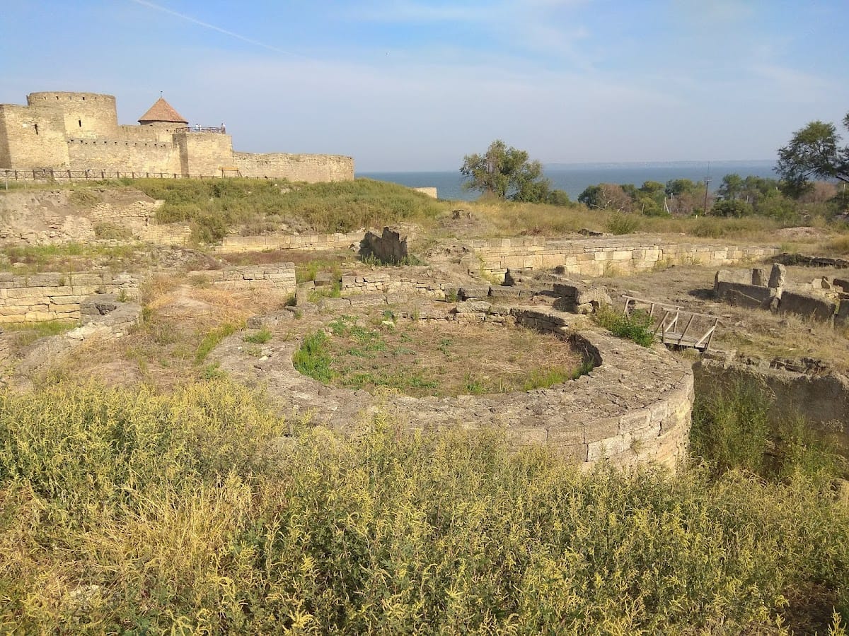
Tyras occupied a high cape on the western shore of the Dniester Liman, near the Dniester delta, with its port on the riverbank inside the ancient town’s boundaries. The low-lying commercial quarter and port were partly destroyed by the waters of the liman, while other areas now lie beneath the medieval fortress, its forecourt, and the modern town. About 11 to 12 hectares of ancient cultural deposits survive outside the fortress. The ancient city probably covered 6 to 12 hectares, including its submerged area.
Ancient urban quarters and defenses
Occupation layers extend from the late fifth century BC to the fourth century AD. They include residential quarters, streets, defensive works, and other remains. Some of the earliest possible features are basement rooms built at the very end of the fifth or the beginning of the fourth century BC and later rebuilt.
Housing and streets
Tyras contained stone houses, stone-paved streets, and a drainage system. Pre-Roman houses generally lacked an architectural order, meaning that they did not use a formal classical arrangement of columns and related elements. They covered about 150 to 330 square metres and had basement and ground floors. Later houses sometimes included courtyards paved with stone slabs laid over broken pottery.
Defensive walls and towers
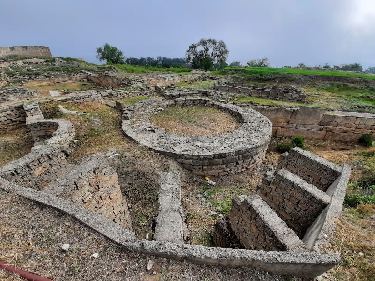
The earliest defenses probably date from the end of the fifth or the beginning of the fourth century BC. They were repeatedly damaged and rebuilt, and their three principal chronological sections cannot yet be related with certainty. The northern section included defensive walls and a freestanding circular tower about 11 metres in diameter, built from massive, carefully worked rectangular slabs and blocks with rusticated surfaces.
A second section, probably built after the destruction associated with the campaign of Zopyrion, consisted of two curtain walls. Farther south, another section included a curtain linking the circular tower with the northwestern defenses, a southern curtain joining it to a pentagonal tower, and a further curtain south of that tower. The southern defenses, built in the late Hellenistic period or possibly during the Roman period, used exceptionally large slabs and blocks and a construction method different from the northern and northwestern works.
Roman citadel and military remains
The Roman citadel appeared in the second century AD and covered at least 2.5 hectares. It incorporated parts of the earlier defenses, including the circular and pentagonal towers and the northern and southern curtain walls. Several walls and towers survive, together with a single-room building used by a legionary detachment.
Citadel entrance and legionary building
The entrance stood on the western side of the citadel. Its surviving threshold has recesses for fastening a small door. The legionary building occupied the northwestern part of the enclosure and had walls made from massive rectangular slabs set on edge. It was surrounded by a paved area containing numerous fragments of marble slabs with Latin inscriptions and by two perpendicular streets. Poorly preserved remains of a two-column portico were found west of the building.
Roman houses and workshops
Roman houses excavated north of the citadel overlay Hellenistic structures and sometimes reused their walls as foundations. Most lacked a formal architectural order, although capitals of the Tuscan order, a simplified classical order with plain columns and capitals, and column bases indicate that more formally designed buildings also existed.
One eastern house combined residential, domestic, and production spaces. Its southern part contained a circular stone vat, two furnaces for smelting iron, slag and charcoal, pieces of iron, fragments of iron objects, and a kiln for firing pottery. The house had two building phases and was destroyed by fire during the first half of the third century AD. Coins of Geta and Caracalla lay in the destruction layer.
Two hoards came from this house. One contained 31 Roman denarii, 149 bronze coins of Tyras, an Olbian tetrassarion from the reign of Septimius Severus, a gold ring with an image of Hermes, and a gold snake-shaped ring. The second contained five denarii and 52 Tyran coins, the latest struck under Caracalla.
A similarly constructed house west of the First Transverse Street contained residential and production rooms with furnaces, including one linked to jewellery production. A residential room held an altar, a herm of Dionysus, a warrior figure with a shield, a relief of the seated Moirai, and fragments of ritual vessels. The room may have served as a domestic shrine.
Later occupation and tomb
A partially excavated apsidal building stood near the circular tower. It may have been constructed after the tower had ceased to exist, indicating a later phase of occupation in this part of the ancient settlement.
Only one stone Roman-period tomb survives from the Tyras necropolis. Known as the Scythian Tomb, it was covered by a barrow five metres high. Its interior walls were decorated with undulating and spiral relief patterns. Much of the necropolis was built over by later settlements.
Medieval and early-modern fortress
The archaeological remains are concentrated mainly between the eastern wall of the medieval fortress and the steep slope at the edge of the delta. Residential areas and a wall with towers have been excavated there, while investigations within the fortress and elsewhere have been more limited.
Fortress layout
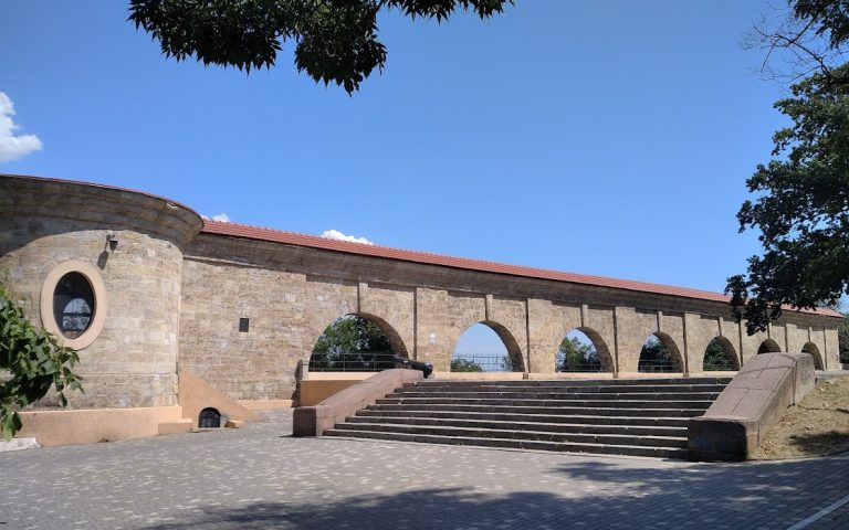
The Bilhorod fortress was built over the ancient city and early medieval settlement. It is an open fortified complex of stone and earth defenses covering about nine hectares. Its divisions included a citadel, a southern civilian section, a northern area for the military garrison, and a western section connected with port activities. A deep ditch protected the complex. The southern section had eastern and western gates, connecting gates joined the southern and northern sections, and another gate led from the northern section to the citadel.
Towers and construction phases
The southwestern citadel tower, the donjon or principal fortified tower, was built first. Three further towers were then added to complete the citadel, probably by Genoese builders. An outer ring of walls with thirty towers was constructed afterward. The fortress and its approaches were reconstructed by the Ottomans during the second half of the eighteenth century.
The fortifications incorporate Byzantine, Ruthenian, Genoese, Moldavian, and Ottoman building and engineering traditions. Their design was adapted to the surrounding landscape. Together with the submerged, buried, and overlain remains of Tyras, the fortress forms a multilayered cultural landscape in which ancient Greek and Roman, medieval, and early-modern structures occupy the same historical setting.