Towada Shrine: A Sacred Mountain Sanctuary beside Lake Towada


Site at a Glance
- Rating
- 4.4
- Popularity
- Medium
- Country
- Japan
- Primary era
- Modern
- External website
- Open
- Eras represented
- Early Modern, Modern
- Civilizations
- Japanese, Tokugawa
- Site type
- Religious
- Remains
- Sanctuary
On this page19 sections
History
Towada Shrine is a shrine in Japan, beside Lake Towada at Yasumiya in Okuse. Its foundation is traditionally dated to AD 807, and its origins are associated with the sacred mountain traditions of the Towada volcanic rim. One legend links its establishment to Sakanoue no Tamuramaro, an early Heian-period court commander traditionally associated with imperial campaigns in northeastern Japan. Unable to cross the stormy lake during an eastern campaign, he is said to have built a small shrine, prayed there, and then crossed on a raft.
Origins and sacred traditions
A second foundation tradition centers on Nanso-bo, a legendary Buddhist monk associated with the origins of Towada worship. According to the story, Nanso-bo entered final meditation on a rocky plateau behind the shrine and was transformed into the dragon deity of Lake Towada. This deity was known as Towada Seiryu Gongen. A gongen was a deity understood in syncretic religion as a manifestation of a Buddhist figure or principle.
Before the Meiji-era separation of Buddhism and Shinto, the site formed the central sanctuary of a major mountain-religious center called Nukadake Kumano Mountain Juwanji. Kumano ascetic practice combined Buddhist, Shinto, and local sacred traditions through mountain training, pilgrimage, and ritual. Lake Towada and the inner slopes of the volcanic rim were regarded collectively as Towada Mountain, or the sacred mountain. Monks and ascetics trained there, while ordinary people visited on pilgrimage. The area was traditionally closed to women.
The pilgrimage landscape divided movement from the secular world into successive sacred boundaries. Rivers, waterfalls, gateways called torii, and shrines marked the first boundary. A mountain pass and a place for worship with a view of the lake marked the second. Beyond Yasumiya, pilgrims purified themselves in the river now called the Kanda River before entering the cedar-lined approach to the central sanctuary.
Early-modern pilgrimage and patronage
Towada pilgrimage reached its height during the Edo period. The Morioka domain maintained the pilgrimage routes and the cedar avenue at Yasumiya, while a magistrate from Gonohe represented the domain lord at the annual festival on May 15. Pilgrims mainly came from the Morioka domain, with additional visitors from the Hachinohe and Sendai domains. The former prohibition on women was eventually lifted, and several hundred men and women were said to have climbed to the shrine for the festival.
The Morioka domain also protected the temple at Yasumiya from outside religious forces and excluded ascetics who did not follow the Kumano tradition. In 1681, local people financed a new sanctuary. Villages contributed stone lanterns and stone guideposts along the approach, several of which remain. Writings by Sugae Masumi in 1807 and Matsuura Takeshiro in 1849, along with pilgrimage guides and materials preserved in the Towada Chronicle, describe the routes and practices of early-modern worship.
Sevenzaki Eifukuji was regarded as the base from which the sacred mountain was opened from the Nukabe side. Its main temple moved to Morioka in the early Edo period, while Fugen-in at Sevenzaki and Mine-shoin at Sannohe became affiliated temples. Fugen-in was traditionally believed to predate Eifukuji, with its opening attributed to the early Heian period and its formal establishment assigned to the monk Gyokai in 1171. From the Kamakura period until the early Edo period, Eifukuji was reportedly used chiefly as the name of the institution.
After its main temple moved to Morioka, Eifukuji became a guardian temple for Morioka Castle, a prayer temple of the domain lords, and the leading temple of the Morioka Five Mountains. It held temple lands assessed at 800 koku, a historical measure of land revenue based on theoretical rice production, as well as extensive grounds and six affiliated residences. The domain controlled much of Sevenzaki Village and maintained a room called the Towada Chamber. Towada’s sacred presence was believed to appear there during the spring and autumn equinoxes in human or dragon form.
The second Morioka-domain lord, Nanbu Toshinao, was traditionally said to have regarded himself as the reincarnation of the founding monk and adopted the Buddhist name Nanshuin Gekkei Seiko. His devotion formed part of the domain’s wider support for Towada worship.
Meiji transformation
Meiji government policies separating Buddhism and Shinto severely disrupted the Towada institution. The accompanying suppression of Buddhism led to the removal of syncretic deities, the destruction of Buddhist buildings, and the conversion of some religious sites into Shinto shrines. In 1872, the ascetic religious organization was abolished. Its practitioners had to join the Tendai or Shingon denominations, become Shinto priests, or return to secular life.
The shrine’s former Buddhist administrators tried to convert the temple into Towada Shrine, move the Seiryu Gongen cult elsewhere, and install Yamato Takeru as the shrine deity. Yamato Takeru is a legendary imperial prince and warrior figure in early Japanese mythology. The proposal was rejected. In 1873, the shrine was combined with Shinra Shrine in Okuse, and the Buddhist hall was demolished. Permission to restore the shrine followed two years later, and a modest shrine building was erected on the former hall site.
The Oda family, who served as shrine officials, later moved from Okuse to Yasumiya and worked to preserve Towada worship. The shrine’s principal deities are now identified as Susanoo and Yamato Takeru. Susanoo is a major Shinto deity associated with storms, the sea, and heroic myths. The shrine formerly held the status of a village shrine.
Twentieth-century reinterpretation
In 1905, Wainai Sadayuki succeeded in breeding kokanee salmon in Lake Towada after repeated difficulties, helping to begin the lake’s modern tourism era. Later guidebooks and educational works repeatedly portrayed the older Seiryu Gongen tradition as a harmful superstition that had opposed his enterprise. This interpretation appeared in publications from 1910, 1927, 1928, 1941, and 1942, and the 1942 biography was later adapted for a popular biographical series in 1967.
A 1950 film further dramatized believers as violent opponents of Wainai, depicting ascetics chanting along the pilgrimage road and attacking his household. The spread of this interpretation, together with the weak organization of the surviving religious movement, has been considered a possible reason for the gradual decline of Towada pilgrimage. The shrine’s annual festival is held on May 14 and 15.
Remains
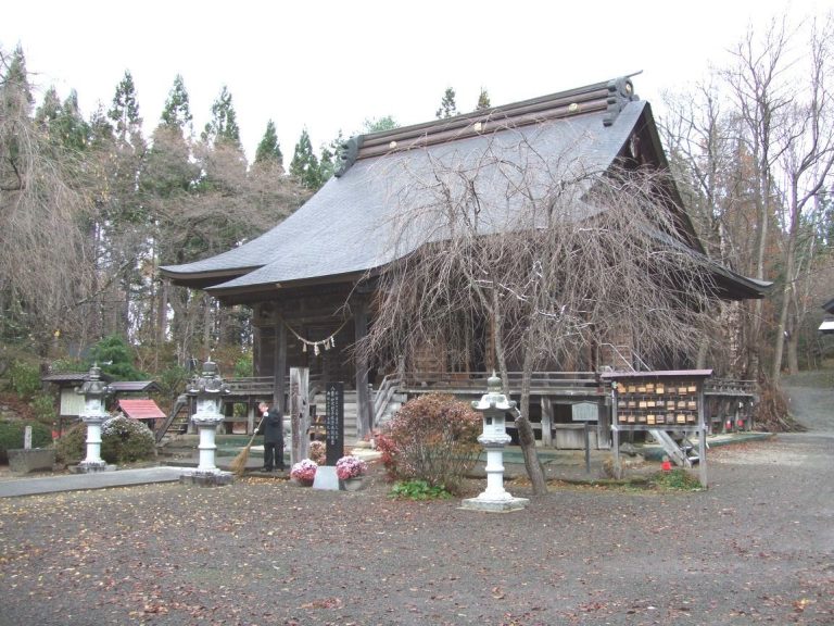
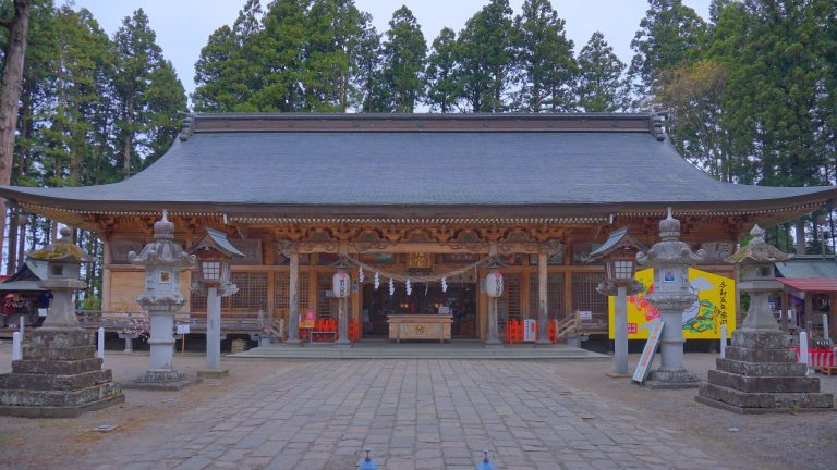
Towada Shrine stands beside Lake Towada at Yasumiya, where the present worship hall occupies the site of the former Buddhist hall called Towada Mido. The shrine and its wider sacred landscape extend through cedar-lined approaches, rock formations, caves, lake shores, islands, mountain passes, rivers, and waterfalls. Together these natural and built features formed the setting for Towada pilgrimage and worship.
The central sanctuary and approach
Towada Mido site
Towada Mido was a roughly square Buddhist hall measuring about three ken on each side, approximately 5.4 meters, and had a pyramidal roof. Kannon, a Buddhist bodhisattva associated with compassion, was installed there as the Buddhist manifestation associated with the local deity. The present worship hall stands on the former hall’s location.
Cedar avenue and subsidiary shrines
In the Edo-period precinct, a stone torii, a gateway marking entry into a Shinto sacred area, led into a cedar avenue. A small subsidiary shrine stood to the left, followed farther inside by the main sanctuary beneath a large rock. A hall for the three Kumano shrine manifestations stood to the left of the main sanctuary at the same height. Twelve subsidiary shrines, each about two to three shaku high, surrounded the complex.
The hall contained offerings such as swords, flags, and votive tablets. Worshippers seeking help also made small forged swords and small iron representations of straw sandals and other footwear, placing them around the hall. About 350 meters of the middle part of the former cedar-lined approach has disappeared beneath an urban streetscape. Other sections retain numerous torii, as well as village-donated stone lanterns and stone guideposts.
Pilgrim shelters
Yasumiya formerly contained several dozen pilgrim shelters called nagatoko, temporary lodging structures used by pilgrims. Set behind small torii, they measured about two to four ken, or approximately 2.6 to 7.2 meters. Their floors were covered with bark and they contained large hearths. Pilgrims left their baggage there before visiting the sanctuary. A cultivated area stood nearby, and local tradition holds that a large temple complex once occupied it.
Routes and purification places
Rivers and mountain roads
The river beyond Yasumiya was formerly called the Purification River. Pilgrims cleansed themselves there before continuing along the approach. Historically, the river marked the boundary between Kazuno and Okuse. It is now called the Kanda River and lies on the prefectural boundary between Akita and Aomori.
Five principal early-modern roads led toward the sanctuary. The Gonohe route began at the medieval Eifukuji at Nanazaki, climbed from Mount Tsukihiyama at the eastern end of the volcanic rim, and reached a lake-view worship place at the summit above Choshi Otaki. It then continued through Choshi Otaki and Utarube to the sanctuary. The Shichinohe route began at present-day Okuse and joined the Gonohe route at Sobe.
The Sannohe route began at Kaimori in present-day Sannohe. The Shirasawa route began at Kemanai, passed through Oyu and Shirasawa, and crossed the lake-view place at Hakka Pass before reaching the sanctuary. The Fujiwara route also began at Kemanai, passed through Nanataki and the lake-view place at Namariyama Pass, and joined the Shirasawa route at the present Oide camping area below Hakka Pass.
Inner sanctuary and divination places
Rocky plateau and Osago Place
A rocky plateau behind the shrine can be reached by climbing the rock mountain at the rear right of the precinct. It overlooks Nakano-umi and the Ogura Peninsula, including the sacred area called Omuro, or the Inner Sanctuary. The plateau was considered holy because Nanso-bo was believed to have entered final meditation there and become Towada Seiryu Gongen.
Below the plateau, at the lakeshore, stood the Osago Place, also called the Divination Place. Pilgrims faced Ogurayama and Omuro while throwing coins or rice wrapped in paper into the lake as offerings and for divination. Osago is a corrupted form of Osanguba, meaning a place for offerings. Four retrieval operations beginning in 1903 recovered about 3,000 old coins from the lakebed in front of the site, including Chinese and Korean coins and Kan’ei Tsuho. A bronze mirror and swords were also found.
Omuro cave
Beyond Five-Color Rock, toward the end of the Ogura Peninsula, is a cave called Omuro. A sign at its entrance identifies it as the Inner Sanctuary. A description from 1922 records a red-brown rocky shore and an arched entrance leading into a chamber large enough for about ten people. Two side passages extended approximately ten ken and more than thirty ken, and bats were reported in them.
Gozengahama and the lakeshore landscape
Fortune Island and the shore
After completing the offering ritual, pilgrims returned to the central sanctuary and continued to Gozengahama, whose name means the shore before the deity. The shore is sandy and contains Armor Island, Helmet Island, Ebisu Island, and Daikoku Island, along with clusters of pine.
Ebisu Island and Daikoku Island lie close together as two slightly separated islands. Because entering them and throwing coins there were believed to bring good fortune, they were collectively called Fortune Island. Old coins have sometimes been found washed onto the beach.
Caves and roadside shrines
The former route between the sanctuary and Gozengahama passed caves and small shrines associated with wind, fire, Hakusan, the sun deity, love, and the market deity. Rock caves linked with fire and wind remain along the path now called the Path of Good Fortune. Caves on the opposite side of the cliff suggest that areas for ascetic practice may once have extended around Gozengahama.
Matsukura Shrine
Matsukura Shrine lies along the southern lakeshore route between the Oirase Stream and Konokuchi, near Utarube. Its present torii is recent, while an early pilgrimage account describes a small hall at a place identified as an older Osago Place.