Torreparedones: An Iberian Oppidum, Roman City, and Medieval Castle in Spain


Site at a Glance
- Rating
- 4.4
- Popularity
- Low
- Country
- Spain
- Primary era
- Classical
- External website
- Open
- Eras represented
- Iron Age, Classical, Medieval, Early Modern
- Civilizations
- Crown of Castile, Iberian, Roman, Spanish, Umayyad
- Site type
- City
On this page25 sections
History
Torreparedones is an archaeological site in Spain, near Baena in Córdoba Province, built and occupied by Iberian, Roman, Islamic, and Christian communities over more than 3,500 years. Its earliest human remains date to the second millennium BC, while its best-known ancient phases include a fortified Iberian settlement and a Roman city that developed on and around it.
From Bronze Age settlement to Iberian centre
Human activity at Torreparedones began by the second millennium BC, during the Bronze Age. Greek and Phoenician colonists began arriving in the region in the eighth century BC, adding new cultural influences to the communities of southern Iberia. By around 600 BC, Torreparedones had become an important Iberian oppidum, a fortified settlement on elevated ground that served as a political, economic, and defensive centre.
The Iberian settlement enclosed more than ten hectares behind a wall approximately one kilometre around. Its position in the Cordoban countryside gave it control over a hill overlooking the Guadalquivir valley. The settlement later became the foundation for a Roman city, which incorporated and combined parts of the earlier urban area with new buildings and institutions.
Sanctuaries and Iberian religious practice
An extramural sanctuary, situated south of the settlement beyond its walls, was used from the third century BC and underwent later renewal. It was associated with Caelestis, a female deity worshipped in the Roman world, and probably with Juno Lucina, a title of Juno connected with childbirth and motherhood. Hundreds of votive offerings, objects dedicated to a deity in fulfilment of a prayer or request, included many representations of pregnant women. These offerings connect the sanctuary with fertility, pregnancy, and childbirth.
A second sanctuary was found about 500 metres from the first after an emergency excavation in September 2020 prompted by clandestine digging. Seven zoomorphic stone offerings in the form of horses were identified there, together with several tombs. The discovery expanded knowledge of the religious landscape surrounding the ancient settlement.
Roman conquest and civic development
Roman occupation followed the conquest of the area. Campanian pottery found throughout the site points to activity during the Roman Republican period, before the establishment of the imperial system. The Roman entrance was enlarged and strengthened during the first century BC, possibly in connection with the Second Roman Civil War, fought from 49 to 45 BC between Julius Caesar and the sons of Pompey.
Under Augustus, the city received a new civic status with elected aediles and duoviri. Aediles were magistrates responsible for aspects of urban administration, while duoviri were paired senior magistrates in many Roman municipalities and colonies. The city has often been identified with Ituci Virtus Iulia, a place mentioned by Pliny the Elder, but more recent archaeological interpretations have instead associated it with Bora, also described by Pliny as Ebora Cerealis. The identification remains uncertain.
Roman Torreparedones developed into a substantial civic centre. Its public buildings included a forum, three bath complexes, a market, an imperial-cult temple, and an amphitheatre. Domestic buildings and cemeteries extended beyond the central urban area. A fragmentary inscription found near the later chapel in 2011 may support the identification with Ituci Virtus Iulia. It refers to a veteran of the Thirty-Third Legion who may have settled in the colony after military service and received land as a reward. The inscription is too incomplete to show whether it originally belonged to an honorific statue pedestal or a funerary monument.
Excavation and interpretation
The Mausoleum of the Pompeys was discovered accidentally in 1833. Excavations between 1987 and 1993 were conducted with the collaboration of the University of Oxford, followed by geophysical survey in 2008 and 2009. Later work revealed the forum, market, bath complexes, inscriptions, and sculptures. Excavations in the sanctuaries took place in 2006 and 2007, while work in 2007 and 2008 located the medieval castle’s parade ground. Major Roman civic buildings and sculptures were exposed in 2009.
The eastern necropolis produced more than one hundred burials, and two further burials were found in 2019. By January 2021, about ten percent of the 10.5-hectare area inside the walls had been excavated. Torreparedones was declared a Spanish cultural-interest property in the archaeological-zone category on 14 November 2007. Public opening followed in 2011, and a visitor centre was established in 2016. Many statues and artefacts recovered from the site are held at the Baena Historical and Archaeological Museum.
Islamic settlement and the medieval castle
Muslim communities occupied Torreparedones from the Caliphate of Córdoba in the tenth century until at least the twelfth century. Pottery, coins, and wall structures belong to this period. After the Christian conquest in the mid-thirteenth century, the place became known as Castro el Viejo and stood near the frontier between the Crown of Castile and the Nasrid Kingdom of Granada.
A trapezoidal castle was built at the end of the thirteenth century. It belonged to Alfonso X, the king of Castile and León, until he granted it to Fernán Alonso de Lastres, commander of the Order of Santiago and governor of Baena Castle. The grant recognised Lastres’s military efforts during the Christian reconquest. The castle continued to have a strategic role until the end of the Granada War.
Later chapel and decline of the settlement
After the castle lost its military function in the sixteenth century, it passed to the Córdoba municipal council and was later auctioned to private buyers during the confiscation of property. The settlement was already almost abandoned when a chapel dedicated to the Mozarabic martyrs Nunilo and Alodia was built in the early sixteenth century. Mozarabs were Christians living under Muslim rule in medieval Iberia, while Nunilo and Alodia were traditionally remembered as ninth-century Christian sisters executed under the Córdoba emirate after refusing conversion to Islam.
The Chapel of the Virgins was severely damaged by the Lisbon earthquake of 1755. It appears in the 1752 Ensenada Cadastre as one of Baena’s eighteen chapels, and a visitor from Córdoba described its altarpiece in 1644. Archaeological excavations beginning in 2013 brought renewed attention to the chapel and its deterioration. The baths and access to the castle tower were restored or made accessible in 2015. The amphitheatre was partly excavated in 2018 and 2019, then re-covered pending acquisition of the land. Consolidation and restoration of the Baker’s House began on 28 December 2020 and ended on 20 October 2021.
Remains
Torreparedones occupies a hill between the municipalities of Baena and Castro del Río, at approximately 579.6 metres above sea level. The ground rises to nearly 600 metres at the castle tower, and the hill overlooks the Guadalquivir valley. The surviving archaeological area brings together the remains of the Iberian enclosure, Roman civic and domestic buildings, sanctuaries, cemeteries, a medieval castle, and a later chapel.
Iberian fortifications and sanctuary
Hill fort and eastern gate
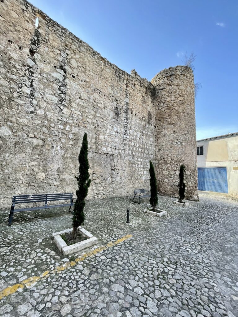
The Iberian fortification enclosed more than ten hectares within a perimeter of about one kilometre. Its towers projected inward, and the earliest houses used adobe and rammed earth. From the fifth century BC, rubble masonry became increasingly common in domestic construction.
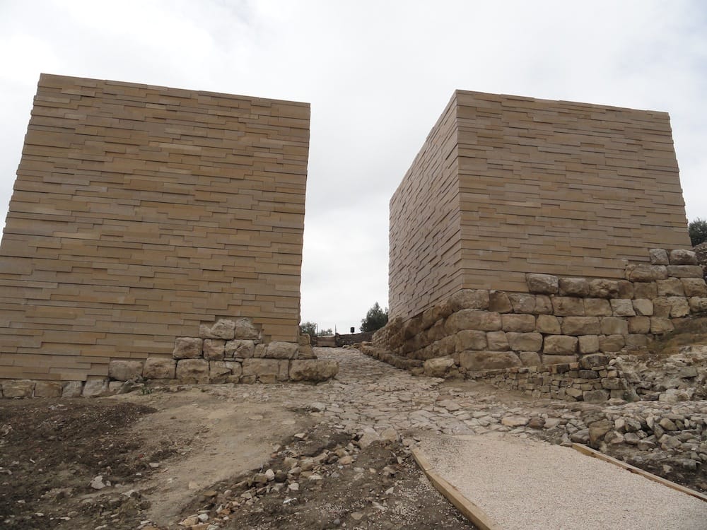
The eastern gate is the only known entrance to the sixth-century BC enclosure. During the first century BC, it was replaced by a larger Roman gateway flanked by two defensive towers. The lower parts of the towers were built in stone, while their upper sections were open structures for guards and war machinery. Two successive doors controlled the entrance, which had a paved pedestrian passage and a central lane for pack animals.
Sanctuary of Caelestis
The sanctuary south of the settlement began with a fourth-century BC building identified during excavations that started in 1988. It was remodelled in the third century BC, when two semicircular stone constructions were added or used as offering places. A further renewal in the second century BC created a sacred building with an internal cella, or shrine chamber, measuring 5 by 4.2 metres. The building opened southward onto a larger room or courtyard.
A central column on a base probably supported the roof or an upper space made from wooden beams, boards, and mortar. Another column stood before the rear wall and may have supported a cult object. A small stone base opposite the cella may have served as an altar. The cult image was an aniconic betyl, a sacred stone or stone-like image that represented a deity without giving it a human form. It consisted of a column topped by a foliate capital. Sunlight reached the capital at the winter solstice and the base at the summer solstice.
Fifty-six statuettes were recovered from the cella, while excavations across the wider sanctuary produced about 290 votive offerings. The sanctuary was probably abandoned in the first century AD, after which the statuettes were broken. A fire destroyed the roof of the still-intact building in the second century AD.
Second sanctuary
The second sanctuary lies about 500 metres from the first. Its excavated remains include seven zoomorphic stone votives representing horses and several tombs. These finds provide physical evidence for another centre of religious activity in the landscape around Torreparedones.
Roman civic centre
Forum and governing buildings
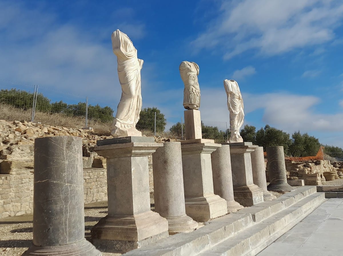
The Roman forum covered about 528 square metres and formed the city’s centre for public, religious, administrative, and judicial activity. It was built under Augustus and paved with limestone slabs from the Sierra de Córdoba during the reign of Tiberius. Colonnaded porticos stood along the northern and western sides. The imperial temple was on the western side, the basilica, a public building for legal and administrative business, stood to the east, and the curia occupied the northwest corner.
Numerous honorific statues decorated the forum, including seated marble figures of Augustus and Claudius. A bronze-letter inscription set into the pavement commemorated the paving of the square by Marcus Junius Marcellus of the Galeria tribe, one of Rome’s civic voting tribes. The curia contained the community treasury, official archive, and a meeting room for 48 decurions and two duoviri. Decurions formed the city’s governing council.
Market
The macellum, a purpose-built Roman food market, covered 380 square metres and had three entrances. It is among the substantially preserved examples of this building type in the Iberian Peninsula. Meat, domestic and game birds, fish, garden produce, and bread were sold there.
The market passed through four construction phases beginning in the first century. It ceased to function as a market in the third century, then continued in other uses, first as an animal pen and later as a cemetery.
Baths and water facilities
Eastern Baths
The Eastern Baths, also called the Baths of Health, were built during the first half of the first century under Tiberius. They were remodelled during the Flavian-Trajanic period and abandoned in the second century. The 220-square-metre complex contained a cold room and changing room, a warm room, and a larger hot room.
The hot room retains original walls more than three metres high, a heated-water pool, a cold-water basin, and a hypocaust, an underfloor heating system. The baths used bicarbonated and sulphurous water considered suitable for rheumatic and digestive therapies. The route of the aqueduct remains unknown, although pipes and siphons may have carried the water. An altar to the goddess of Health and a bronze jug bearing the deity’s head were found in association with the complex.
Other bathing buildings
Small baths stood beside the forum. Another complex, the balneum calpurnianum, was later found beneath the remains of the Chapel of the Virgins. Marcus Calpurnius sponsored the building. Although privately owned, it was open to the public, and its rooms could be reached from the changing room.
Amphitheatre and cemeteries
Amphitheatre
A large Roman amphitheatre stood outside the walls in the municipality of Castro del Río. Aerial photography, remote sensing, and lidar confirmed its position in 2017. The building used the natural slope for part of its seating and had a roughly circular plan measuring approximately 64 to 67 metres across. It was used from the first half of the first century until the second half of the second century. About one-third of its perimeter was excavated before the remains were re-covered.
Necropolises and Mausoleum of the Pompeys
Two Roman cemeteries lay outside the settlement, one to the east and another to the north. The eastern necropolis, beside the visitor centre, contains more than one hundred inhumation graves with niches for the deceased’s ashes.
The northern necropolis included the monumental Mausoleum of the Pompeys. Fourteen stone urns were found inside it, twelve carrying the Pompey family name. The mausoleum was discovered in 1833, while later excavation of the eastern cemetery revealed the large group of burials and helped define the extent of funerary activity around the city.
Domestic and medieval structures
Baker’s House
The Baker’s House occupies the southern part of the settlement and was the first Roman domus, or urban house, at Torreparedones to be completely excavated. It covers about 700 square metres and dates approximately to the first or second century, although earlier domestic structures lie beneath it. Its name comes from a large oven used for bread production. Consolidation and restoration carried out between 2020 and 2021 helped preserve the building.
Castle
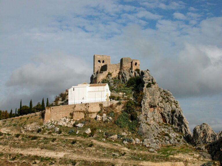
The medieval castle has a trapezoidal plan and occupies the highest part of the site through its tower. The parade ground inside the fortification was located during work in 2007 and 2008. The castle formed part of the frontier landscape between Castile and the Nasrid Kingdom of Granada and retained a military role until the end of the Granada War.
Chapel of the Virgins
The Chapel of the Virgins was built over the Roman balneum calpurnianum. Its surviving remains were examined archaeologically from 2013 onward, following the damage caused by the 1755 earthquake and the chapel’s later deterioration. A small fragmentary inscription carved in local stone was found nearby. Its surviving text refers to the Thirty-Third Legion and a military career, but the original form of the monument, whether an honorific statue pedestal or a funerary monument, cannot be determined.