Sissacherfluh Ruin: A Refuge Hill-Fort in Switzerland


Site at a Glance
- Rating
- 4.7
- Popularity
- Low
- Country
- Switzerland
- Primary era
- Medieval
- Eras represented
- Bronze Age, Medieval, Early Modern
- Civilizations
- Swiss
- Site type
- Military
- Remains
- Fort
On this page12 sections
History
Sissacherfluh Ruin is the remains of a refuge hill-fort near Sissach in Switzerland, occupying the rocks of Sissacher Fluh above the Ergolz Valley. A refuge hill-fort was a fortified enclosure intended to protect people and goods rather than serve mainly as a permanent aristocratic residence. The site was used in several phases over millennia, and it is recognized as a Swiss heritage site of national significance.
Late Bronze Age Settlement
The earliest known use probably dates to the Late Bronze Age, the prehistoric period when bronze became a major material for tools, weapons, and ornaments in central Europe. Archaeological investigation found limited traces of post-built houses in the western part of the enclosure. These remains represent an early settlement phase on the rock, although later activity disturbed much of the earlier evidence.
Early Medieval Fortification
The principal phase probably took place in the Early Middle Ages, when a fortified enclosure was built along the more gently rising northern side of the rock. Its defensive wall enclosed about 2.8 hectares. The steep terrain and vertical rock faces already made the southeastern, southern, and western sides difficult to approach, while the northern side required stronger artificial defenses.
The enclosure was later reused as a high-watch station from the period of the Thirty Years’ War onward. That conflict, fought from 1618 to 1648, brought severe political and military consequences to central Europe. A high watch was a raised observation and signaling station used to detect danger and transmit warnings across a wider territory. At Sissacherfluh, the station formed part of the Swiss Confederation’s warning and reporting system. The outer end of the rock was probably protected by an existing double rampart, which Werner Meyer proposed had originated in the Early Middle Ages and was later refurbished for this purpose.
Excavation and Interpretation
The enclosure was largely excavated in 1936 through a cantonal labour camp and unemployment-relief programme. Its extensive area made the work difficult and laborious. In 2015, the Sissach municipal council, the Fritz Pümpin Foundation, and the Cantonal Archaeology Service of Basel-Landschaft decided to install interpretive labels at the ruins, with implementation planned for 2016.
Remains
Sissacherfluh Ruin stands at about 699 metres above sea level, roughly 2 kilometres north of Sissach. The hill-fort occupies a rocky height whose natural cliffs and steep slopes provide protection on three sides. The main enclosure follows the more gradual northern approach, where the principal defensive wall, northern corner towers, and gate formed the strongest built defenses. The surviving site is chiefly a ruin of wall remains, together with traces of prehistoric houses and later high-watch structures.
Fortified Enclosure
Main Defensive Wall
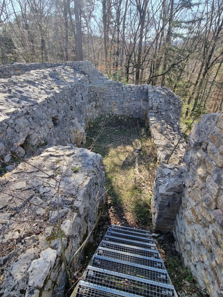
The main wall was approximately 2 metres thick and consisted of two masonry faces enclosing an earth fill. It was originally considerably higher than the conserved remains. Stair supports were placed at regular intervals along the inner side, allowing defenders to reach the walkway along the top of the wall and man it quickly. A gate and a tower stood at the northern corners of the enclosure. The northern-corner tower had an entrance at ground level and may also have provided habitable space.
Northern Foreland
Traces of further gates in the northern foreland indicate that a substantial enlargement of the refuge may have been started but left unfinished. These features extend the defensive arrangement beyond the main enclosure and help explain the importance of the northern approach, where the natural slope was gentler.
Bronze Age Houses
In the western part of the enclosure, the few discovered remains of post-built houses represent the Late Bronze Age settlement. The structures were made with posts set into the ground, a construction method that leaves limited physical traces. Their position provides evidence for occupation within the area later enclosed by the hill-fort.
High-Watch Installations
Watch Structures
Square masonry structures near the rock and the viewpoint survive from the later high-watch installation. They belong to the site’s reuse within the Swiss Confederation’s warning and reporting system and stand apart from the earlier enclosure as a later defensive and signaling arrangement.
Double Rampart
The double rampart around the outer end of the rock is now flattened, but its line remains clearly visible. It probably helped protect the high-watch installation and may have reused an Early Medieval defensive feature that was refurbished for later needs.
Nearby sites