Sarazm: A Proto-Urban Settlement and Exchange Center in Tajikistan
Site at a Glance
- Country
- Tajikistan
- Primary era
- Bronze Age
- Eras represented
- Stone Age, Bronze Age
- Civilizations
- Unclassified
- Site type
- City
On this page22 sections
History
Founding and growth
Sarazm is a proto-urban settlement in Chubot, Tajikistan, occupied from the fourth millennium to around 2000 BCE. A proto-urban settlement has some features of a town before fully developed urban systems. Its precise chronology is uncertain, and its founding population is thought to have arrived from Namazgadepe and nearby oases in southern Turkmenistan. The community developed around farming and livestock raising, with wheat and barley among its crops and cattle, sheep, and goats among its animals. Estimates place its population at about 3,000, rising to nearly 10,000 in its final phase.
Sarazm’s inhabitants also made pottery, jewelry, metal objects, leather goods, textiles, and stone and wooden tools. From the turn of the fourth to the third millennium BCE, the settlement became a meeting point between farming communities and nomadic groups, connecting an extensive exchange network. Goods included lapis lazuli from Badakhshan, carnelian from Kairakkum, turquoise from Khwarazm and Ferghana, and painted pottery associated with Baluchistan, Sistan, and Balkh. Sarazm is linked with the Great Lapis Lazuli Road, and a route through the settlement is considered an antecedent of one Silk Road route.
Metalworking and abandonment
By the end of the third millennium BCE, Sarazm had become a center for processing and exporting tin and bronze. The suggestion that tin from the Zerafshan area supplied Mesopotamia during the third millennium BCE remains disputed. Movement of tin from the region to Mesopotamia, Syria, and Anatolia is considered probable in the early second millennium BCE.
The settlement contracted during its fourth occupation phase and was abandoned around the end of the third or the beginning of the second millennium BCE. Environmental change and drought are associated with its decline; the drying of a local stream or another natural disaster has also been proposed. People moved toward the foothills near the Zerafshan, a population shift linked to the later emergence of ancient Panjakent.
Beliefs and archaeological history
Fire had ritual importance at Sarazm, and animal sacrifice is indicated by remains found in buildings. The fire practices have been interpreted as an early tradition later associated with Zoroastrianism, an ancient Iranian religion connected with Zarathustra in which fire has an important ritual role. This interpretation does not establish that Sarazm’s inhabitants formally followed Zoroastrianism, and their broader beliefs remain uncertain.
A local resident found a bronze axe while plowing in 1976 and later gave it to Tajik archaeologist Abdullojon Isakov. Initial test excavations began in 1977, systematic work followed in 1979, and Isakov led excavations through 1994. French and Tajik archaeologists began working together in 1984; American archaeologists, including Philip L. Kohl and Clifford Charles Lamberg-Karlovsky, joined the work in 1985. The partnership continued into the late 1990s, after which the French mission focused on preservation. Smaller excavations took place from 2002 to 2005.
Tajikistan designated Sarazm a historical and archaeological reserve in 2001. UNESCO added it to the World Heritage List on 31 July 2010 as a center of ancient agricultural culture. It was the first UNESCO World Heritage site in Tajikistan.
Remains
Settlement layout and construction
Overall form and extent
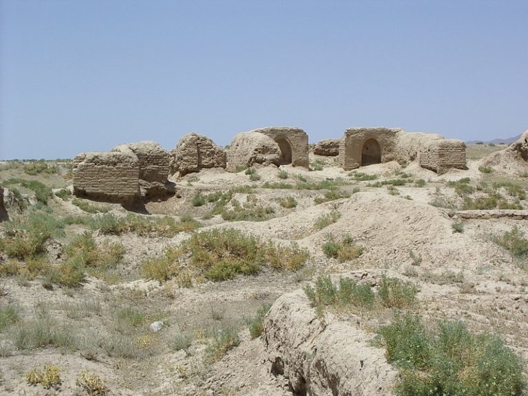
Sarazm lies on the southern bank of the Zerafshan River, about 15 kilometres west of Panjakent and roughly 910 metres above sea level. The settlement extends for about 1.5 kilometres, with a width estimated at 400 to 900 metres. Estimates of its total area range from about 90 to 150 hectares; approximately 35 hectares are recognizable, and around 2.5 hectares have been excavated. The settlement had an irregular overall layout. Its remains form four occupation layers, generally 1.5 to 2 metres deep, with periods of abandonment between them. Their distribution differs between excavated areas, a pattern interpreted as evidence of settlement shifting over time. The visible remains chiefly belong to phases II and III.
Domestic buildings and lanes
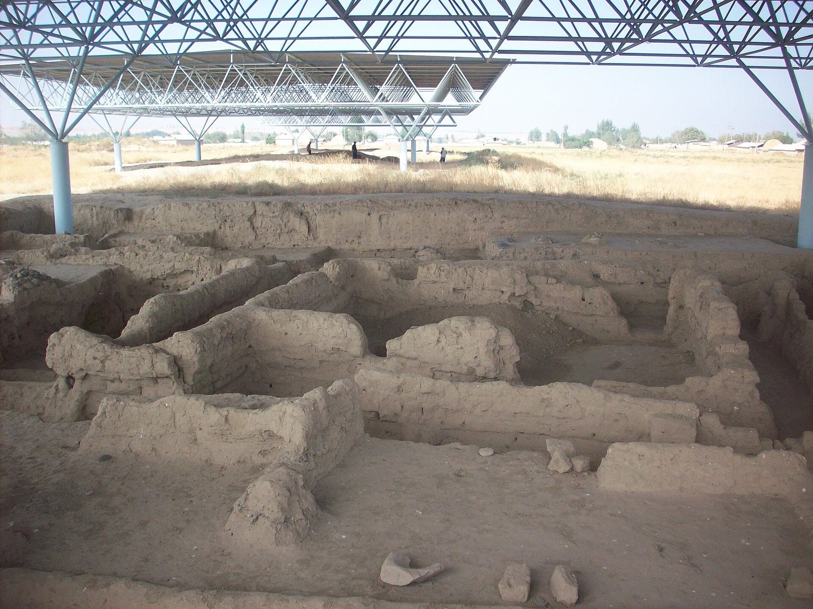
Buildings included houses, workshops, storage areas, and structures interpreted as public, religious, or palatial. They were generally made of sun-dried mud bricks or shaped earth, with plastered walls that were sometimes painted. Some foundations in the latest occupation layer used river stone. Roofs were flat, formed over beams with reeds and branches, then sealed with clay. Houses in all four phases had several rooms for living, storage, and cooking; most also had walled courtyards. Lanes of different widths ran between buildings, and open areas served as places for cattle. Differences in building size have been taken to indicate emerging social distinctions.
In phase II, narrow passages about 50 to 60 centimetres long and 20 to 25 centimetres wide connected buildings within complexes and led to courtyards where bread ovens were found.
Protection of exposed remains
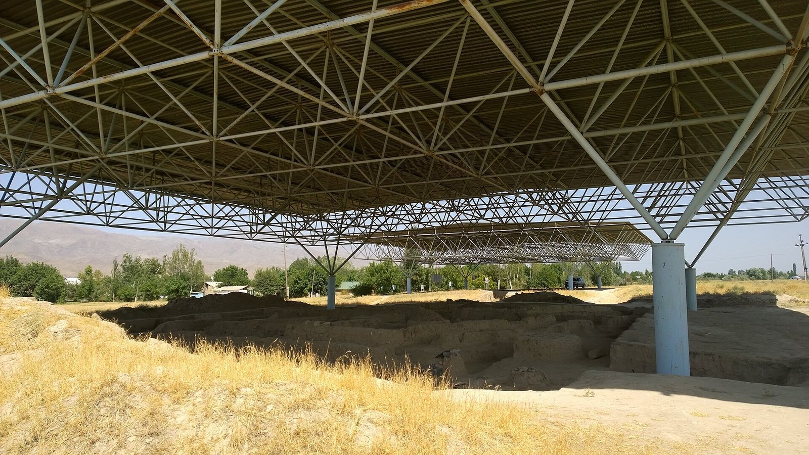
Protective roofs cover five excavation areas: V, IX, XI, XII, and XIII. Some other exposed areas were reburied. A covering made from rice husk and stabilized earth was developed to protect fragile remains.
Public and religious buildings
Public building in Area III
A building interpreted as public stood on a platform measuring 15 by 15 metres and 0.7 metres high. Its central section contained eight rectangular rooms arranged in two rows. Two corridors flanked the rooms on each side. The rooms may have served residential or administrative purposes, while the corridors have been interpreted as grain-storage spaces.
Building in Area V
A 16 by 16.5 metre building in Area V had six rooms of different sizes and has been interpreted as a palace.
Religious building in Area IV
A separate religious building in Area IV covered 128 square metres and contained four rooms. Two rooms held square installations interpreted as places for ritual activity.
Ritual spaces and installations
Household fire spaces
Small, round spaces containing fire installations occurred inside houses during phase II. In phase III, both round and square forms are recorded, and the spaces became larger. Some installations in Areas IV and IX stood outside houses. Fire installations may also have been used for everyday tasks.
Two structures in Area V
A circular structure in the second layer of Area V consisted of two rings. The outer ring measured 7.7 metres across and the inner one 4.25 metres, with a passage 75 centimetres wide between them. Its mud bricks measured 52 by 25 by 10 to 11 centimetres. Isakov interpreted the structure as a solar symbol. In the third layer, it was replaced by a cult building measuring 5 by 7 metres, with a round fire altar at its center.
Temple in Area XI
A similar temple in the third layer of Area XI had a central room surrounded by a corridor where burnt offerings took place. Bones in its southwest corner belonged to a Caucasian goat interpreted as a sacrifice. Some sanctuaries retained traces of painting around their altars, including a Maltese-cross design.
Water and craft production
Irrigation works
Irrigation works drew water from the Zerafshan and from the mountains. A canal about one kilometre long was intended to protect fields from periodic flooding, while a narrower channel supplied higher fields to the north. An excavated channel was 16 metres wide and is estimated to have been about 1.5 metres deep.
Kilns and pottery
Round pottery kilns were excavated in Areas II and VI, in phases II and III. One measured 2.4 by 1.9 metres and contained a thick layer of grey stone powder beneath the ash. The powder has been interpreted as an additive used in clay. Phase I pottery includes dark-brown designs on lighter surfaces. Later vessels used dark-brown and reddish patterns on red or pale-yellow surfaces, alongside painted circles, crosses, triangles, lines, and net patterns in red, yellow, and blue. Rosette designs may indicate knowledge of a solar calendar. Pottery in phase III was made with a slowly turning wheel.
Metalworking and other crafts
Furnaces for smelting metal, remains of smithing ovens, mould fragments, and slag provide evidence of metal production. Excavated metal objects include knives, daggers, axes, spear points, awls, chisels, and ornaments; gold and silver objects and lead seals were also found. Techniques used in the third layer have been compared with those known from Mesopotamia to the Indus Valley.
Other finds include stone and bone needles, weaving equipment, woollen textiles, and fired-clay figures of women and animals. A cylindrical seal associated with the Proto-Elamite tradition, an early writing system connected with southwestern Iran, bears an image of a bull.
Burial and grave goods
In Area IV, a burial enclosed by a circular stone wall 15 metres in diameter contained a woman aged 19 or 20, a man aged 20 or 21, and a girl. Four more people were buried some distance away. The woman, identified as a mother, is popularly known as the “Queen of Sarazm.” She was buried on her side with her body bent and facing east. Her grave goods included thousands of beads made from lapis lazuli, steatite, carnelian, turquoise, and silver; 49 gold beads in her hair; shell bracelets made from a marine gastropod; a gold necklace; a clay figure; and a mirror and cosmetic items.