Ricciacum Archaeological Site: A Gallo-Roman Roadside Settlement in Luxembourg




Site at a Glance
- Rating
- 4.5
- Popularity
- Very Low
- Country
- Luxembourg
- Primary era
- Classical
- External website
- Open
- Eras represented
- Classical
- Civilizations
- Celtic, Roman
- Site type
- City
On this page16 sections
History
Ricciacum Archaeological Site in Luxembourg preserves the remains of a Roman settlement at Dalheim, founded around 17 BC as a Gallo-Roman roadside station on the Via Agrippa. The settlement stood in the Roman province of Gallia Belgica, within the territory of the Civitas Treverorum, the Roman administrative district of the Treveri. Positioned at a strategic junction roughly midway between Metz and Trier, Ricciacum developed from a service station into a small Roman town and the probable administrative centre of a regional district.
Before and During the Foundation
Celtic objects point to settlement on the plateau during the Late La Tene period, although extensive Roman construction has made the earlier settlement difficult to locate precisely. The Roman vicus, a small settlement commonly established along a major road for trade, administration, and travel services, appears to have been a new foundation connected with the planning and construction of the Via Agrippa. This road network was developed under Marcus Vipsanius Agrippa during the reign of Augustus and linked Ricciacum with major centres including Metz and Trier.
The first Roman buildings consisted of timber strip-houses with stone cellars. Their occupants included artisans and merchants, while the settlement’s position on the road supported the sale of manufactured goods and the provision of food and lodging for travellers and pilgrims. The main road divided at Dalheim, creating connections toward Stadtbredimus and Trier on one branch and toward Medingen and another road to Trier on the other.
Reorganization and Expansion
Following the Batavian revolt of AD 69 to 70, a major uprising against Roman rule in the Rhine region, Ricciacum was extensively reorganized. The main road was widened from about 7 metres to 10 metres, and timber buildings were progressively replaced by stone structures. During the second half of the first century, particularly under the emperor Vespasian, the settlement acquired a more durable architectural form and began to take on the appearance of a Roman town.
The scale of this expansion suggests that Ricciacum served more than passing traffic. Its public buildings, substantial temple district, theatre, and baths indicate a regional role, while its growth is consistent with the settlement’s position as the centre of a pagus, a regional administrative district in the Roman provincial system. At its greatest extent, around the end of the second or the beginning of the third century, Ricciacum covered about 35 hectares and supported an estimated population of 1,500 to 2,000 people.
Religion and Civic Life
Religious activity formed an important part of Ricciacum’s public life. The settlement possessed a large temple district and numerous dedications. It may also have functioned as a pilgrimage sanctuary beside the Via Agrippa, although the principal temples cannot be assigned with certainty to specific deities. Cults associated with Minerva, Mercury, Jupiter, Epona, Fortuna, Ceres, Vesta, Victoria, and Nemesis are represented at the site. Mercury, in particular, was associated with trade and travellers, while Epona was a Celtic goddess connected with horses and riders.
The theatre, temple district, and baths gave Ricciacum its monumental character. Together with the road network and commercial activity, these buildings support the interpretation of the settlement as a local civic and administrative centre rather than merely a place for travellers to stop.
Attacks, Fortification, and Abandonment
Ricciacum was repeatedly attacked and partly destroyed during Germanic incursions in the second half of the third century. Fires and destruction layers extended across the settlement, and the population declined. Parts of the vicus were repaired or rebuilt, however, and occupation continued into the first half of the fifth century.
At the beginning of the fourth century, a burgus, a fortified roadside post or small defensive installation, was built at the road junction. Its foundations incorporated large stone blocks taken from the theatre, which had ceased to operate in its original form after the third-century destruction. The theatre grounds continued to be used into the fifth century for an unidentified purpose. Ricciacum itself was abandoned only after occupation had continued into that period.
Names and Archaeological Research
The ancient settlement is named as Ricciaco in the road-station entry of the Tabula Peutingeriana, a medieval copy of a late Roman road map. Lead tesserae bear the forms RICC and RICCIAC, while an inscription from 2008 mentions the vicani Riccienses, the inhabitants of the settlement. These finds provide the basis for identifying Dalheim with the ancient road station, although the forms Ricciacum and Riccium may represent alternate names or a scribal error. The name also survives in the nearby field-name a Retzeg, formerly Ritzig, and in the tenth-century name of the regional district Rizzigau.
Alexander Wiltheim, a seventeenth-century Jesuit scholar and antiquarian, was the first to describe the remains near Dalheim as a Roman archaeological site. Investigation expanded in the mid-nineteenth century, when the Archaeological Society of Luxembourg excavated the area before construction of the Three-Cantons Road. The resulting reports prompted comparisons between Dalheim and Pompeii, although the earliest investigators initially interpreted the remains as a Roman military camp rather than a civilian settlement.
Ernest Dupaix, a nineteenth-century notary clerk and antiquities collector, carried out important excavations, especially in the temple district. His work produced a large collection of objects, including two high-quality bronze statues now held by the Louvre in Paris. Systematic excavations by the archaeological service of Luxembourg’s National Museum of History and Art began in 1977 and continued through excavation campaigns, test trenches, construction monitoring, and geophysical surveys.
The discovery of the theatre in 1985 extended research from the plateau into the area beneath and around the modern village. Much of the ancient settlement remained unbuilt over, allowing aerial photography, geomagnetic survey, and ground-penetrating radar to reveal a relatively detailed plan. A regional archaeological research centre opened at the site in 2016 to support the systematic study of Dalheim’s ancient history.
Remains
Ricciacum extended across the high plateau south of modern Dalheim and into the valley below the present village. Its central area lay on both sides of the Via Agrippa, which followed a long, exceptionally straight route through the settlement before dividing toward several destinations. Narrow, elongated plots lined the road, with their short sides facing the street. Shops and taverns occupied the frontage, while covered porticoes sheltered access from sun and rain. Workshops, gardens, wells, and ovens lay farther back, though only a small part of these rear areas has been excavated.
Settlement Quarters
The earliest houses were long rectangular timber buildings with stone-built cellars. Several rebuilding phases followed, and during the second half of the first century these structures were systematically replaced by stone buildings. Wells occurred on every excavated plot and provided the only water supply on the high plateau. The principal excavated quarter also contains evidence for numerous craft businesses, reflecting the working population that supported the roadside economy.
Fire and destruction layers extend through the vicus and represent the repeated attacks of the third century. Some buildings were later repaired or rebuilt, preserving evidence for continued occupation after the destruction. The settlement’s street-facing plots, working areas, and public buildings formed an organized urban environment extending from the plateau down toward the valley.
Temple District
The temple district occupied a substantial area and included an octagonal temple and at least four other cult buildings. Two large temples investigated between 1986 and 1998 probably date from around AD 130 and remained in use into the third century. One was a podium temple, raised on a solid platform, while the other was a Gallo-Roman ambulatory temple with a central room surrounded by a roofed passageway. Earlier foundations beneath them belonged to two probable ambulatory temples constructed during the second half of the first century. Three temples have been exposed in excavation.
Nineteenth-century work revealed the ground plan of the octagonal temple and recovered many objects associated with Roman religious activity. Among them were the two bronze statues that entered the Dupaix collection and are now held in the Louvre. The dedications and buildings together indicate that the district served a wide religious community, possibly including pilgrims travelling along the Via Agrippa.
Gallo-Roman Theatre
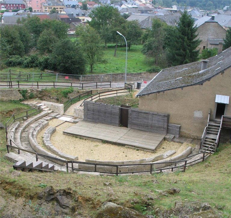
The theatre stood on the steep Fielsgaart slope north of the plateau, demonstrating that Ricciacum extended into the valley. It was built during the first quarter of the second century in a former stone quarry. In its earliest form, only the outer walls were made of stone, while the seating and stage were constructed from wood.
Stone seating ranges were added toward the end of the second century. At the same time, the corners of the walls were heavily reinforced to withstand the pressure of the slope. The first two seating rows incorporated backrests or armrests and backrests and were reserved as places of honour. Their front section was added at the beginning of the third century. In its final form, the theatre could accommodate more than 3,500 people.
The building served more than theatrical performances. Foundations for altars in the orchestra indicate that religious activities took place there, probably in the area between the first seating rows and the stage. Excavations between 1999 and 2007 to 2008 examined almost the entire structure. A destruction layer outside the theatre contained fire debris from the vicus and a skeleton bearing clear blows to the skull, regarded as a possible victim of the Germanic incursions. During the fourth century, massive blocks from the upper seating ranges were removed for the foundations of the fortified roadside post on the plateau.
Public Baths
A public bath complex stood near the theatre. Roman wall remains were first encountered during roadworks in 1962 and 1978. Test excavations in 2003 and 2004, followed by more extensive investigations in 2008 and 2009, exposed several rooms after adjoining buildings had been demolished.
The excavated complex included a frigidarium, the cold room of a Roman bath, with a bathing basin, and a northwestern tepidarium, a warm room heated beneath the floor. An open courtyard surrounded by a columned portico formed another part of the complex. Stone deity statues found during excavation may originally have stood in this courtyard.
The baths were probably constructed at the end of the first or the beginning of the second century and were altered several times. A fire in the middle of the fourth century destroyed the complex, which was not rebuilt. Debris from the destruction included a stone altar or inscribed relief block from the middle of the third century. Its inscription names Ricciacum and describes the destruction of the baths’ portico during a barbarian attack, providing a rare direct record of an event otherwise known chiefly through ancient written accounts.
Burial Grounds and Roadside Features
Hossegronn Burial Area
In the small Hossegronn valley, the settlement’s burial grounds included two funerary monuments, about forty cremation graves, and two inhumation graves. Burial began there during the second half of the first century. Other cemeteries probably followed the roads leaving Ricciacum, and numerous gravestones found in fields around Dalheim during the eighteenth and nineteenth centuries are associated with these burial areas. A separate fourth-century cemetery with strong Frankish influence lay near the present parish church of Saints Peter and Paul.
Roman Milestones
Two fragmentary Roman milestones came from the surroundings of Dalheim. One, probably found between 1870 and 1900 southwest of the settlement near present-day Filsdorf, survives as two pieces of an originally cylindrical stone. Four lines remain readable, and the milestone dates to the reign of Philip the Arab. The other was found beside the CR 153 in the Buchholz area in 1934 and dates to approximately AD 121, during the reign of Hadrian.
Buchholz Sanctuary
A small roadside sanctuary in the Buchholz area was a Gallo-Roman ambulatory temple measuring 8 by 7.5 metres. It stood directly beside the Roman road toward Medingen and Trier, whose route at this point is followed by the modern road. Discovered in 1934, the temple contained two heavily fragmented stone deity statues still standing in their original positions. One represented the seated Mercury, while the female figure probably represented Rosmerta, a Celtic goddess often associated with Mercury. A fragmentary inscription naming Mercury indicates that the sanctuary was probably dedicated to him and possibly to Rosmerta.
Eagle Monument
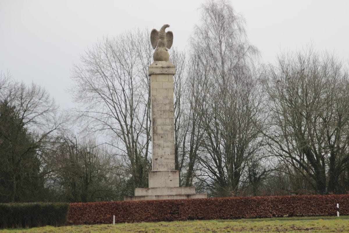
The Eagle Monument was erected in 1855 by the Archaeological Society of Luxembourg to commemorate the Roman settlement and has become a symbol of Dalheim. Its substantial stone base incorporates large blocks excavated nearby during nineteenth-century investigations. The blocks date probably from the middle of the third century and may have been taken from the theatre for construction of the burgus. The monument was inaugurated on 28 May 1855 in the presence of William III of the Netherlands, who was also Grand Duke of Luxembourg. The eagle stands on a globe, facing Trier while its body faces Metz, expressing the ancient road connection between the two cities.