Rathcroghan: An Archaeological Complex and Royal Site in Ireland
Site at a Glance
- Popularity
- Very High
- Country
- Ireland
- Primary era
- Iron Age
- Eras represented
- Stone Age, Bronze Age, Iron Age, Medieval
- Civilizations
- Irish
- Site type
- Religious
- Remains
- Sanctuary
On this page20 sections
History
Rathcroghan is an archaeological complex near Tulsk in County Roscommon, Ireland, identified with Cruachan, the traditional capital of the Connachta, the people associated with the kingdom of Connacht. One of Ireland’s royal sites, it is a ritual landscape whose monuments span the Neolithic, Bronze Age, Iron Age, and medieval periods. Archaeological evidence supports its use as a cemetery and gathering place, while the literary accounts of a royal residence and fortress remain unconfirmed.
A landscape of successive periods
The complex preserves evidence of activity from the Neolithic (about 4000 to 2500 BC), the Bronze Age (about 2500 to 500 BC), the Iron Age (about 500 BC to AD 400), and medieval times. Its varied monuments include burial mounds, ringforts, enclosures, long earthworks, and field boundaries. A ringfort is a circular enclosure defined by a bank and ditch, often associated with settlement. Several were built at Rathcroghan toward the end of the first century AD, and some later incorporated underground passages.
Medieval field banks, especially around Relignaree, point to grazing use across parts of the landscape. This may have been connected with an early medieval fort at neighbouring Tulsk. Small groups of houses between the monuments may have continued to be occupied beyond the Middle Ages. Nearby Carnfree was an inauguration place for the O’Conor kings of Connacht and is also associated with the wider medieval complex.
Cruachan in Irish tradition
Irish literary and historical traditions remember Cruachan as a royal seat and a place for a major fair or assembly. They also name it among Ireland’s three great pagan burial places, together with Tailtiu and Tara. The complex appears in early Irish literature, including the twelfth-century Lebor na hUidre. In the Táin Bó Cúailnge, a medieval heroic tale of a cattle raid and conflict involving Medb and the Brown Bull, Cruachan is Medb’s royal seat and the setting for the story’s opening and conclusion. Another tradition puts the bulls’ final fight at Rathnadarve.
The Dindshenchas, a body of Irish place-name lore, offers a mythic explanation for the name Cruachan. Its poem says the place was named for Crochen, a handmaid of Étaín. Midir gave Crochen a síd, a mound associated with the supernatural or Otherworld, and the poem identifies her as Medb’s mother. In stories of the Ulster Cycle, Medb receives Connacht from her father, Eochaid Feidlech, after he deposes Tindi Mac Conra for treachery. One version says Medb’s sister Clothru ruled at Cruachan before Medb killed her. It remains uncertain whether Tindi ruled from this site or whether it was established for Medb.
Cruachan is closely linked in tradition with Samhain, an ancient seasonal festival associated with the opening of graves and the passage of spirits. In “The Adventures of Nera,” the warrior sees spirits destroying Cruachan’s royal buildings and learns that the scene foretells events a year later unless his companions are warned. Nera tells Ailill mac Máta, who then destroys the supernatural mound. Other stories place destructive beings in Oweynagat. The traditions do not establish whether the mound in every tale means the cave or Rathcroghan Mound.
Several tales connect Oweynagat with the Morrígan, a supernatural figure associated with battle and prophecy. In the Táin Bó Regamna, she emerges from the cave in a chariot drawn by a one-legged chestnut horse, taking a cow to breed with the Brown Bull with the help of a giant carrying a forked staff. In another story, the Morrígan turns Odras into a river after Odras follows her into the cave in pursuit of stolen cows. An eighteenth-century tale tells of a woman who follows a runaway cow inside and emerges at Keshcorran in County Sligo.
Other accounts tell of magical wildcats that attack three Ulster warriors before Cúchulainn tames them, and of the three-headed Ellen Trechen, killed by Amergin. Red birds whose breath withers plants and destructive pigs hunted by Ailill and Medb also feature in the stories; the pigs are said to vanish and shed any flesh that has been captured. The cave’s name may derive from the wildcats in “Bricriu’s Feast.” Some interpretations also connect Medb with a local earth goddess. In a tradition of kingship, the king symbolically married the land and became one with Cruachan. The inauguration may have taken place on Rathcroghan Mound, but this remains an interpretation.
Christian period and later study
Rathcroghan’s religious importance declined after Christianity arrived. The prologue to the Martyrology of Oengus, a medieval calendar of saints’ days, contrasts Cruachan’s waning power with the rise of Clonmacnoise, an important early medieval monastery. A notice dated 1681 BC is protohistorical rather than secure evidence for events in that year. More firmly dated references say that laws associated with St Patrick were promulgated at Crúachan in 783, followed by laws associated with St Ciarán in 814. The Triads of Ireland, known in versions from the fourteenth to nineteenth centuries, list a cave among Ireland’s three darkest places; its identification with Rathcroghan remains uncertain.
Surveying began in the mid-eighteenth century. Gabriel Beranger made a colour drawing of Cruachan Mound, and the Ordnance Survey’s work in the 1830s assigned monument names that remain in use. Later radar and magnetic surveys revealed buried features comparable to those at Tara and Emain Macha.
Remains
Rathcroghan covers about 6 square kilometres and contains more than 240 archaeological sites. The landscape combines burial mounds, circular enclosures, long earthworks, and medieval field boundaries. The principal monuments are dispersed across the complex, while Rathcroghan Mound lies within a large circular enclosure.
Mounds and enclosures
Rathcroghan Mound and its enclosure
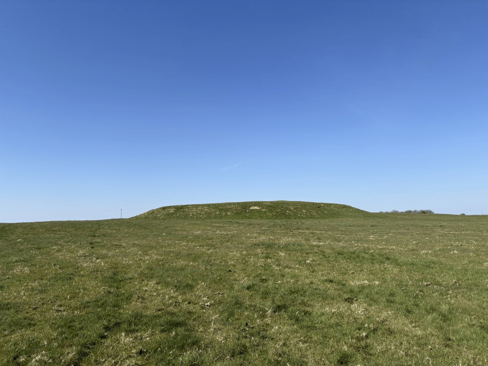
Rathcroghan Mound is broad and circular, with a level summit. Its base averages 89 metres across, and it rises 5.5 metres. Gentle ramps on its east and west sides lead to the top, where traces of a smaller mound remain. Surveying has shown that the mound covers an earlier monument formed by two concentric stone rings. A circular enclosure about 360 metres across and 5 metres deep surrounds the mound and other monuments. Its form has been compared with enclosures at Tara, Emain Macha, and Dún Ailinne.
Rathmore
Rathmore is a steep-sided, grass-covered mound about 40 metres across, encircled by a ditch 7 metres wide. It may date from the late Iron Age or early medieval period. Possible postholes on its small summit could belong to a communal hall or another circular building of the Iron Age. Surveys inside the mound have detected hearths, pits, and ovens, evidence consistent with habitation.
Rathnadarve
West of Rathcroghan Mound, Rathnadarve is a large circular ringfort with a substantial bank and an outer ditch. Breaks in the bank include a possible entrance on the northeast side. Its name means “fort of the bulls.”
Relignaree
Relignaree, meaning “burial place of the kings,” is a circular enclosure about 100 metres across. Its bank of stone and earth now stands about a metre high, and traces of an inner enclosure about 48 metres across survive within it. Older field banks cross the site, dividing it into four unequal parts. The remains of five rectangular houses lie within and around the enclosure. A souterrain, an underground passage or chamber, was excavated in its southwest quarter in 1872, when animal bones were recovered.
Dathí’s Mound
This embanked burial mound is about 40 metres across, with entrances opposite one another on its east and west sides. A red sandstone pillar, 1.85 metres high, stands on the mound. Investigations in 1913 found that it had been shaped from a natural gravel ridge, a conclusion supported by a limited excavation in 1981. Charcoal samples point to construction between 200 BC and AD 200, earlier than the traditional death date, around AD 429, of the last pagan High King associated with it.
Rathbeg
About 600 metres northwest of Rathcroghan Mound, Rathbeg is a mound approximately 36 metres across, classified as a ring barrow, a burial mound surrounded by a circular bank or ditch. Three rings encircle it in tiers. A double ditch runs along three sides, with another ditch to the west. At the summit, a small stone mound is enclosed by banks and ditches that form a series of terraces. Worked flint from the mound dates to the Iron Age and possibly the Bronze Age, while its overall form is consistent with Neolithic monuments.
Carnfree
Carnfree is a nearby mound associated with the wider Rathcroghan complex. It is also linked with the medieval landscape around the site.
Cave and stone features
Oweynagat
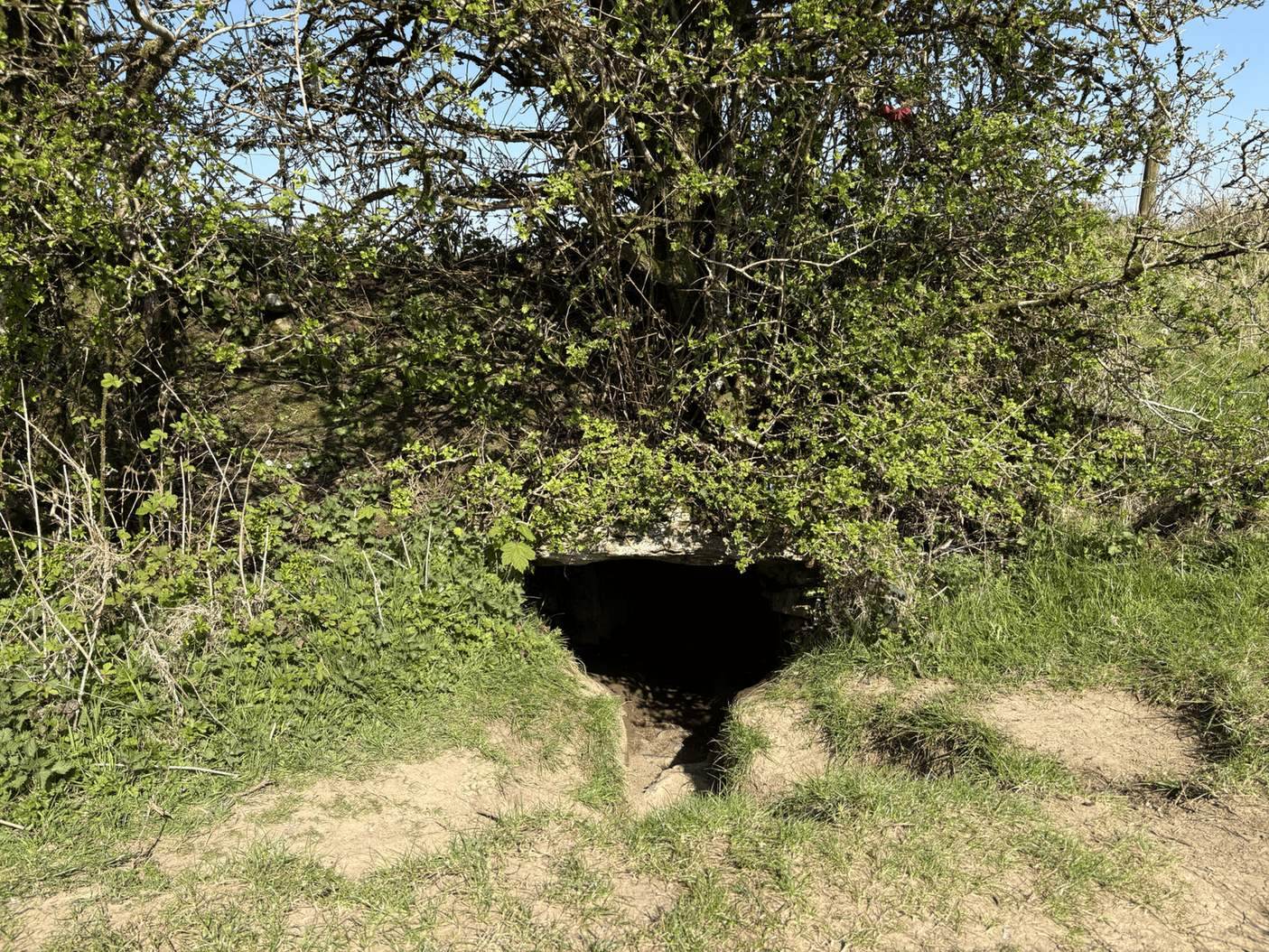
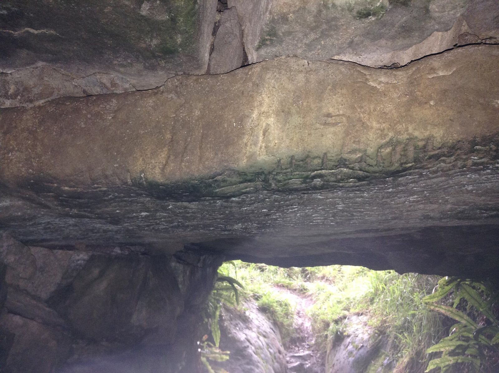
Oweynagat, meaning “Cave of the Cats,” is a narrow natural limestone cave with a human-built souterrain at its entrance. The entrance was once enclosed within an earthen mound, disturbed during road construction in the 1930s. The passage uses dry-stone walls, upright stones, and horizontal lintels, stones spanning openings. It runs about 10.5 metres from the entrance to the natural cave, which continues for another 37 metres.
An Ogham inscription, written in an early Irish system of strokes along a line, appears on the lintel just inside the entrance. It reads ‘VRAICCI…MAQI MEDVVI’ and has been translated as ‘of Fraech, son of Medb,’ though the link to the literary Fraech is uncertain. A second, incomplete inscription on another lintel reads ‘QR G SMU’ but cannot be interpreted confidently.
Cashelmannan
Cashelmannan, or “fort of Manannán,” consists of the foundation remains of an oval stone fort. It is the complex’s sole stone-built structure. Three close-set concentric banks of earth and stone, each about 1.5 metres wide, define the enclosure. Its interior is 40 metres across, while the outer dimensions are 57 metres north to south and 63 metres east to west. Two rectangular enclosures, each marked by a single bank, adjoin it on the north and east. The purpose is uncertain, though the stone construction has been taken to suggest a high-status building with defensive features.
Misguan Medb
Near Rathcroghan Mound lies Misguan Medb, a fallen standing stone.
Earthworks and settlement traces
The Mucklaghs
The Mucklaghs are two curving earthworks that run northeast to southwest, 78 metres apart. Each has two banks accompanied by three ditches. The northern earthwork is 100 metres long; the southern one extends about 280 metres. Their purpose is uncertain. Folklore connects their name with the Irish word for “pig” and says that a giant boar made them by rooting through the ground.
The Ancient Avenue, Rathscreig, and Flanagan’s Fort
The Ancient Avenue is a sunken trackway about 15 metres wide, edged by two low parallel banks. Part of it crosses the outer bank and ditch of Rathscreig, a ringfort with a small mound at its centre. The avenue appears to end at Flanagan’s Fort, another ringfort with a central mound. Both forts were built later than the trackway.