Mesas do Castelinho: An Iron Age Settlement in Portugal
Site at a Glance
- Popularity
- Medium
- Country
- Portugal
- Primary era
- Classical
- Eras represented
- Classical, Medieval
- Civilizations
- Roman, Umayyad
- Site type
- Military
- Remains
- Fortified Town
On this page9 sections
History
Mesas do Castelinho is an archaeological settlement in the União das Freguesias de Santa Clara-a-Nova e Gomes Aires, Portugal. Its occupation began around the transition from the fifth to the fourth century BCE, when it formed a fortified settlement near a watercourse. Natural defenses and a position overlooking a route across the mountains between Alentejo and Algarve gave the community a strategic location.
Iron Age settlement
Although the wider area has evidence of Chalcolithic, or Copper Age, and Bronze Age activity, occupation at Mesas do Castelinho began later, in the Iron Age. The settlement belonged to a type found in pre-Roman southwest Iberia: a fortified community situated beside a stream. Its position also connected inland routes with the Guadiana and surrounding areas.
Finds point to exchange with both coastal and inland communities. Amphora fragments indicate the arrival of goods not available locally, including marine products. Coins connect the settlement with Myrtilis, the ancient name of Mértola, a regional center linked by the Guadiana to Alentejo and the Mediterranean. Some vessels were made locally or nearby in forms drawing on Punic models, associated with Carthaginian culture and its Phoenician roots. Poor schist soils restricted farming, while livestock raising was probably the community’s main economic activity.
Roman occupation
Occupation resumed around the transition from the second to the first century BCE, after Roman military control had been established in the Iberian Peninsula. The settlement was reorganized on a grid-like plan, with streets laid out along intersecting lines, probably after its original walls had disappeared. It was eventually abandoned.
Umayyad resettlement
People settled at the site again during the tenth and eleventh centuries under the Umayyads, a Muslim dynasty that ruled parts of the Iberian Peninsula. A rural community occupied the lower platform, while a small castle stood on the higher platform above the earlier settlement’s ruins.
Local traditions, damage, and archaeological work
A local tale described a woman living alone at Monte do Castelinho who was visited at night by another woman. The visitor claimed to live underground with a “lizard man” and promised luck and fortune to anyone who embraced him. People also imagined houses beneath the site, perhaps because the ruins lay below ground level. These traditions may have encouraged the landowner’s 1986 search for treasure. Heavy machinery levelled about a third of the ruins, destroying most remains on the southern platform and damaging part of the other one.
Descriptions of the remains appeared over several decades. After visiting the region in 1897, Portuguese archaeologist and ethnographer José Leite de Vasconcelos wrote about Castelinho in an article published in 1933. In 1948, military officer João de Almeida described the settlement as a Muslim-period watchtower. Around a decade later, archaeologists Abel Viana and Octávio da Veiga Ferreira, together with local priest António Serralheiro, published a fuller account with photographs and warned that agricultural machinery threatened the site.
Archaeological work began in 1987 under Carlos Jorge Alves Ferreira, whose team cleared damage from the previous year and surveyed the ruins. Carlos Fabião and Amílcar Guerra joined as directors in 1988, and excavations began the following year with southern regional archaeological services. Work continued in most years for nearly three decades. Excavations examined the Umayyad fort in sector A1 from 1989 to 1992, Roman Republican-period buildings beside it from 1992 to 1994, and second Iron Age levels from 1994. Further work extended across sectors A2 and A3 and the B1, B2, and B3 areas of the second platform, refining the settlement’s chronology. Portugal classified the site as a Property of Public Interest in 1990. Finds from Mesas do Castelinho are exhibited at the Manuel Vicente Guerreiro Archaeological and Ethnographic Museum, which opened in Santa Clara-a-Nova in 2015.
Remains
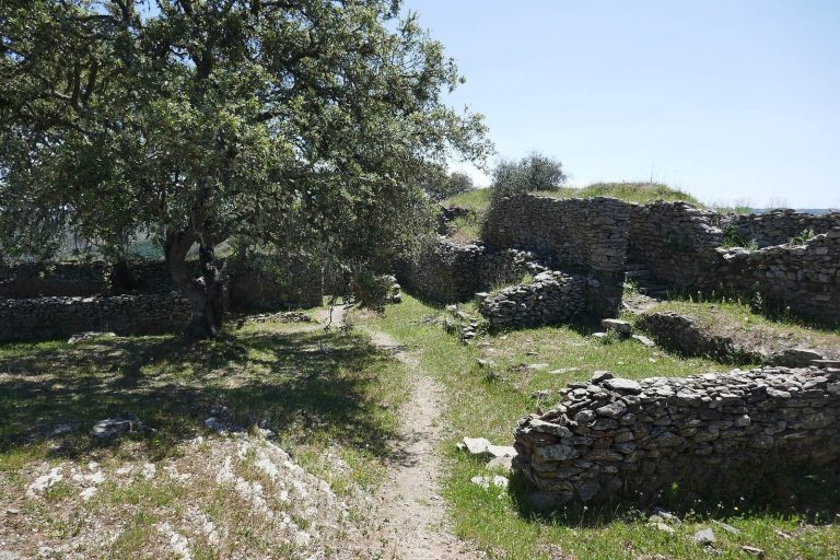
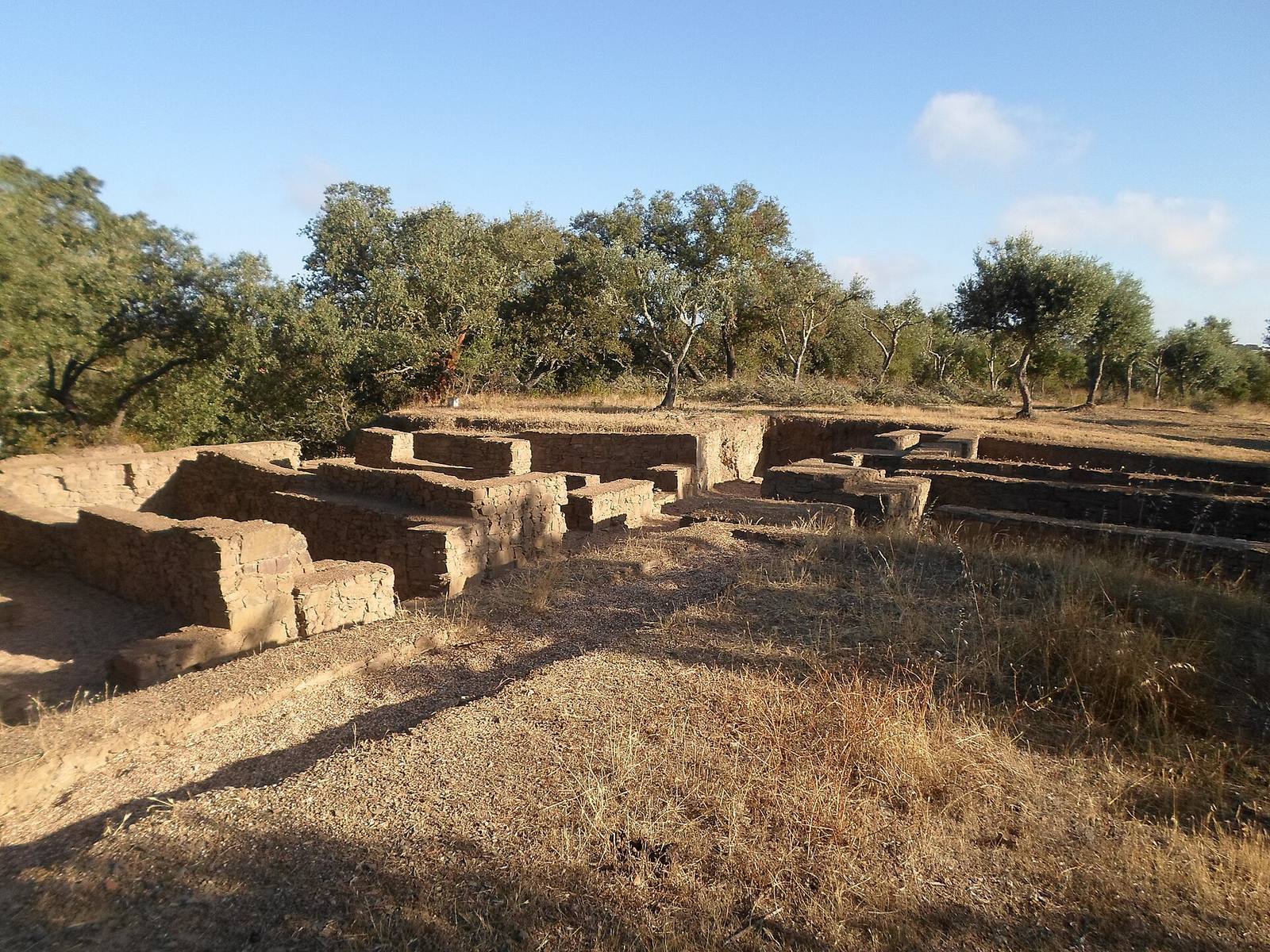
The archaeological area covers about four hectares. The settlement extends roughly 250 metres from north to south and averages about 100 metres in width. The Mora stream and two ravines form natural boundaries on three sides, with access from the south. Its two adjoining platforms comprise a larger, trapezoidal platform to the north and a higher, circular one to the south. A third platform partly surrounds the southern one and is especially visible on the west. Retaining walls held sediment over time, forming the mesa-like landforms that gave the site its name. The settlement lies about two kilometres from Santa Clara-a-Nova in an isolated inland setting; the separate Monte Branco Necropolis is about 400 metres away.
Platforms and occupation areas
Platform A contains remains from the Iron Age, Roman, and Islamic periods, while platform B preserves several Roman-period streets. The Umayyad settlement’s arrangement included rural occupation on the lower platform and a small castle on the higher one, built over earlier ruins. Together, these features preserve evidence of successive uses across the two platforms.
Pottery and other finds
Pottery from the site spans the Chalcolithic, late Bronze Age, Iron Age, and Roman periods. Roman material includes amphorae and terra sigillata, a fine Roman ceramic ware often recognized by its smooth, frequently red surface. Some examples are associated with Italy, Gaul, and Hispania. Excavated finds also include animal bones and metal objects such as coins, rings, and brooches.
Inscribed stele
A funerary stele found on 5 September 2008 in a street in the Roman area bears an inscription in the Southwestern script, an ancient writing system used in southwestern Iberia.