Limes Gate at Dalkingen: A Roman Frontier Crossing in Germany
Site at a Glance
- Popularity
- Medium
- Country
- Germany
- Primary era
- Classical
- Eras represented
- Classical, Modern
- Civilizations
- German, Roman
- Site type
- Military
- Remains
- Gate
On this page18 sections
History
Roman builders began developing the Limes Gate at Dalkingen, a frontier crossing in Rainau, Germany, around AD 160. The site formed part of the Raetian frontier, within the Roman border system known as the Limes, and remained in use from about AD 160 until at least the third century. It connected the Empire with territory beyond Roman rule, and its six successive building phases reflect changing arrangements for monitoring passage across the frontier.
Frontier control and timber phases
The earliest phase may have included a woven-branch fence along the intended border, a timber watchtower beside the later gate, and a narrow wicket for passage. Around AD 165, or possibly in late AD 165 or early AD 166, Roman builders replaced the fence with a line of oak poles. The area around the tower may then have been adapted for more regular border checks.
A wooden gate building was later constructed beside the tower. It may have been prompted by a road from Fort Aalen, running through Fort Buch and onward beyond Roman territory; the route’s continuation outside the Empire can no longer be traced. Guards at the gate and troops serving the nearby watchtowers came from Fort Buch, about two kilometres southwest. Travelers leaving Roman territory approached from the south, and Buch may have been an important last stop. Cross-border trade was associated with prosperity at its civilian settlement.
Stone rebuilding and Caracalla’s campaign
Shortly before the third century, the timber watchtower appears to have deteriorated. A replacement tower was built on a stone foundation, while the wooden gate continued to operate. During the reign of Emperor Septimius Severus, the Raetian frontier wall was constructed in stone. The earlier tower and gate were then reduced to their foundations, and a stone gate took over the passage.
Probably in AD 213, during Emperor Caracalla’s campaign against Germanic peoples, the gate’s southern wall was demolished and replaced with a monumental façade. This rebuilding may have been connected with the emperor’s visit to the frontier. A fragmentary inscription records that Caracalla crossed the Raetian frontier on 11 August AD 213, although the crossing point is not known with certainty. The gate may have served the Roman army during the campaign. Fort Aalen, linked to it by road, had a garrison of about 1,000; the Alamanni, a confederation of Germanic peoples, have been suggested as possible opponents. A different interpretation, proposed in 1993, saw the final building as a sanctuary set against the frontier wall rather than a triumphal gate.
Fire, abandonment, and the frontier’s end
The complex burned and was not rebuilt. Its destruction has been linked to Alamannic incursions in AD 233 or 234, but the final coin from the gate dates to AD 231–235, and no evidence of an attack in those years has been found at nearby Buch. Another proposal places a Germanic raid as late as early summer AD 254, the year Buch’s settlement was destroyed by fire. How long the local frontier remained intact before the Limes finally collapsed in AD 259 or 260 is uncertain.
Excavation and changing interpretations
The first known excavation took place in the early nineteenth century. In 1873, archaeologist Ernst von Herzog surveyed the remains, noting pottery, a bronze fragment from a female statuette, evidence of an excavated tower, and extensive rubble. The objects recovered during that work are now considered lost. Further excavations followed in 1885 under state conservator Eduard Paulus the Younger, with Eduard von Kallée responsible for visual records. In 1886, archaeologist Karl August von Cohausen published the first reconstruction of the gate.
In 1934, archaeologist Oscar Paret proposed that the site was a small field fort rather than a monumental gate. Investigations led by archaeologist Dieter Planck in 1973–1974, conducted while roadworks threatened the rubble mound, established a different interpretation: a gate altered repeatedly and equipped with rooms for frontier guards. The site had been restored by 1975 and underwent major refurbishment in 2000. The gate became part of the UNESCO World Heritage listing for the Upper Germanic-Rhaetian Limes in 2005 and a specially protected cultural monument in 2006. It also forms part of an open-air museum established in 1972, which includes Fort Buch and its civilian settlement.
Remains
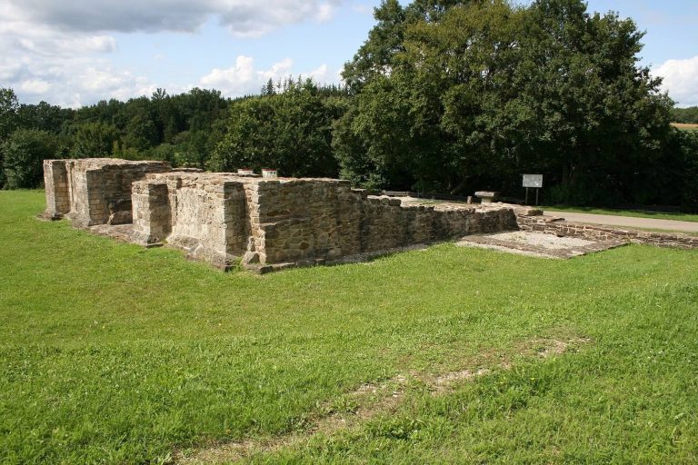
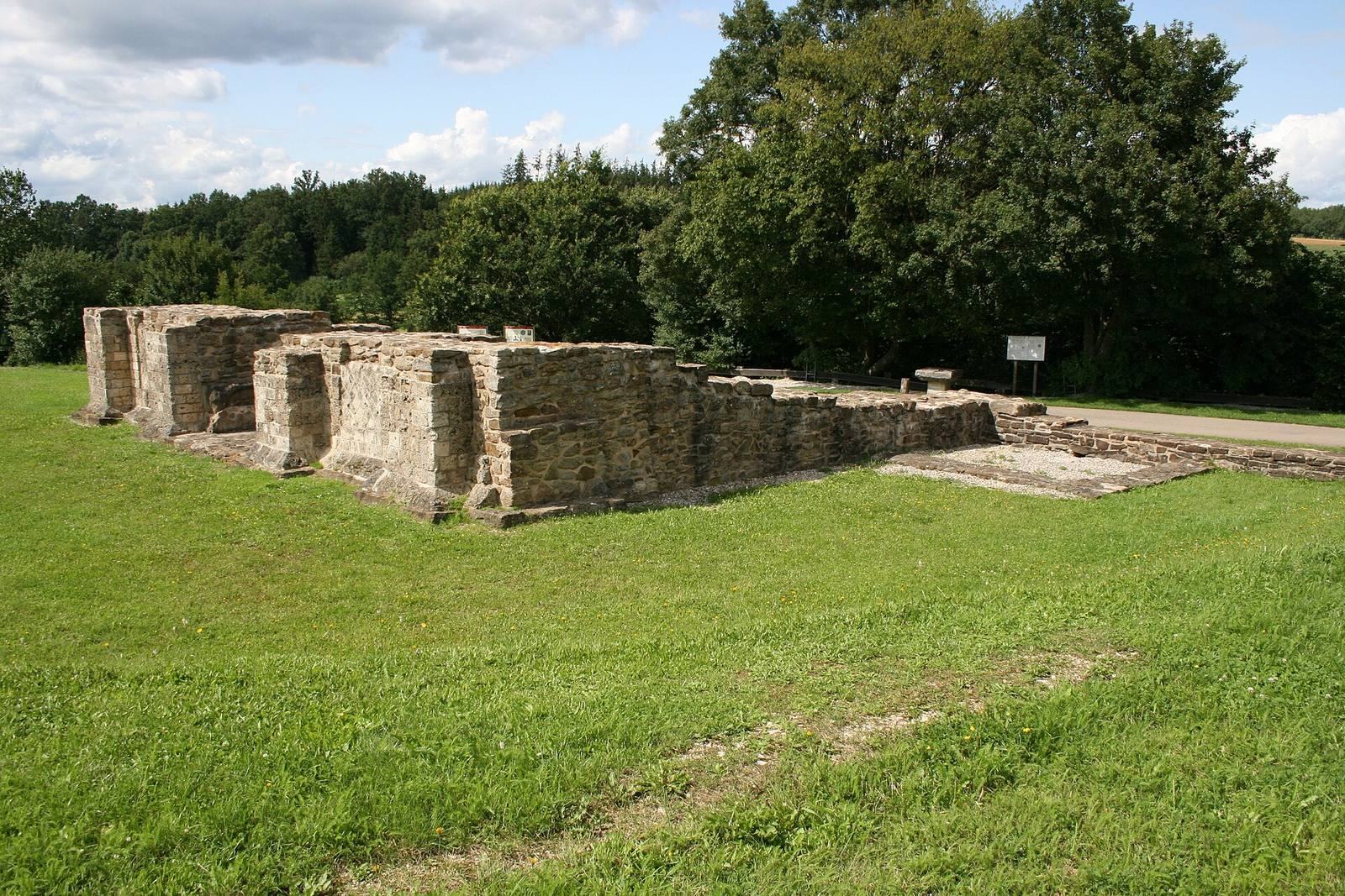
The gate stood on an exposed hilltop between Schwabsberg and Dalkingen, with its principal display façade facing south. The frontier wall runs north of the remains. The excavated structures preserve successive arrangements of fences, towers, and gate buildings, while a modern steel-and-glass cover now protects parts of the complex.
Timber frontier and first gate
Fence lines and watchtower
The earliest woven-branch fence crossed the area of the later gate, about two to five metres farther toward the unoccupied territory than the later Raetian Wall. A square trench immediately west of the gate foundations may mark a timber watchtower about 5.5 metres on each side. Post settings along its southwest side may have screened a small wicket gate from view.
The following oak-pole fence stood in a narrow trench about three metres north of the earlier line. Regular semicircular indentations along the trench’s inner edge indicate rear reinforcement. The fence left a passage beside the tower, then bent around it to form an open court on two sides.
Wooden gate and later tower
The first gate building was largely rectangular and symmetrical, measuring 13.3 by 14.5 metres. Deep post pits supported its timber structure, which had a passage running from south to north. Three rooms stood northwest of the passage and four southeast of it; they may have served as guard, living, and administrative spaces. The earlier timber tower was probably incorporated into the building and remained in use.
A later tower stood southeast of the gate, on a foundation measuring 5 by 4.8 metres, about seven metres behind the oak-pole fence. Its upper structure may have been entirely stone or made of timber resting on the stone base.
Stone gate and monumental façade
Stone gate building
The stone gate measured 12.6 by 9.3 metres and stood slightly southeast of the earlier wooden building. Its northern front joined the Raetian Wall. An impression in the ground at the centre of this front marks the position of a large threshold stone. The wall crossed the former tower’s northern side, cut through the earlier gate area, and then bent west.
Final façade and statue
In the final phase, builders replaced the southern wall with a carefully constructed façade founded more deeply than the rest of the building. The façade was up to 3.4 metres wide, and its eastern and western surfaces were faced with lime tuff. Two shallow rectangular projections resembling columns framed each side of a single-lane passage about 2.1 metres wide. Recessed panels between them used small lime-sinter stones set in a net pattern.
More than 140 bronze fragments from a larger-than-life armoured statue were recovered, mostly in front of the southwest-facing display side. They include strips from a breastplate and a sword pommel decorated with an eagle’s head. The statue was probably an imperial image, made late in Hadrian’s reign or early in the reign of Antoninus Pius and later reused at the gate. Its head may have been replaced to represent another emperor.
A limestone slab measuring 1.23 by 1.21 metres may have served as a statue base. It was taken from the rubble mound in 1873 and reused as a step at a cemetery entrance. After road paving in 1962, it was replaced with concrete and placed behind the cemetery; Dieter Planck recovered it in 1974. Detailed examination from 2010 noted a dovetail-shaped hole on one side, consistent with a possible pedestal use.
Associated features and archaeological finds
Lime kiln
A round kiln found about 100 metres south of the gate during work in 1978 may have supplied lime for the frontier wall or gate. Probably Roman, it measured about 4.2 metres across. Its hemispherical pit descended about 1.3 metres into natural marl and contained a further, nearly rectangular shaft about 0.7 metres deep. Air channels led into the pit; openings for them were built into a dry-laid rubble-stone wall along its southern side.
Square building southeast of the gate
Ground surveys in 2012 and 2014 revealed an unexcavated stone building about 50 metres southeast of the gate. It measures 20 metres on each side, and its northeast wall is almost exactly aligned with the Limes. It has been interpreted either as a sanctuary or, more probably, as a small Roman fort.
Personal objects and military equipment
Eight bronze brooches used to fasten clothing date to the late second and early third centuries. Their forms include bow-shaped, swastika-shaped, band-shaped, and S-shaped examples. Other finds include a fragment of a masked helmet, pieces of bronze horse harness, partly tin-plated brooches, and decorative buttons.
Seven spearheads were recovered. Four may relate to a ritual marking of the building site: two were driven into undisturbed ground on either side of the approach road in front of the southwest façade, and one was found on each side of the passage. Other military objects include a dagger-sheath fragment, a bronze fitting from a sword scabbard with heart-shaped cutouts, and bolts for rapid-firing artillery powered by twisted cords or sinew.
Tools and household equipment include a hammer, an iron awl, a small drill, a woodworking scraper, an axe, knives, keys, and parts of scissors. The excavations also recovered fragments of at least two cast-iron spoons and a cast-iron ladle. Animal bones with chopping marks show that meat was prepared at the site. Together, the weapons, tools, and food remains indicate continuing Roman military occupation of the passage.
Coins and other finds
Fifteen coins were recovered during the 1973–1974 excavations and further work in 2009. Now held by the Württemberg State Museum and the Limes Museum in Aalen, the group begins with two coins of Hadrian and two of Antoninus Pius. It also includes two coins issued for Faustina I, wife of Antoninus Pius. One is a dupondius, a Roman coin denomination, probably made as an ancient forgery.
Numerous pottery fragments were catalogued. Copies of a bust of Caracalla, a Roman milestone, and an inscription honoring the emperor are displayed at the site.
Protective cover
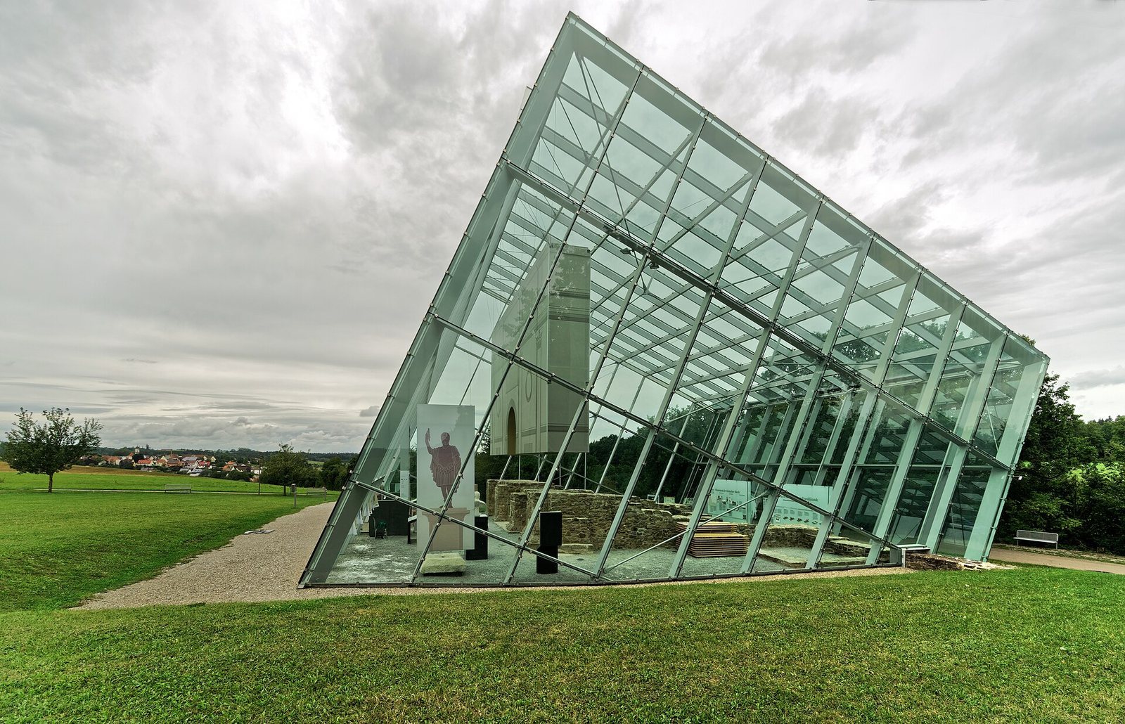
A steel-and-glass structure built in 2010 protects the remains and reduces maintenance needs. It stands 16 metres high and covers an area 23 by 21 metres, crossing the earliest timber predecessor and enclosing parts of the later ancient buildings. Its height was based on the presumed height of the Roman gate. Full-size printed fabric panels inside suggest the gate’s possible appearance and dimensions above the surviving stone remains.