Kirchenburg Ostheim: A Fortified Church Complex in Germany


Site at a Glance
- Rating
- 4.6
- Popularity
- Low
- Country
- Germany
- Primary era
- Early Modern
- External website
- Open
- Eras represented
- Medieval, Early Modern
- Civilizations
- Holy Roman Empire
- Site type
- Religious
- Remains
- Fortified Church
On this page17 sections
History
Kirchenburg Ostheim is a fortified church complex in Ostheim vor der Rhön, Germany, built and expanded by the town’s citizens and peasants for worship and refuge during periods of warfare. Its history reflects the politically fragmented border region associated with the bishops of Würzburg, the abbots of Fulda, and the counts of Henneberg. The complex developed from a fifteenth-century churchyard fortification into a large Renaissance-era Protestant town church enclosed by walls, towers, storage buildings, and vaulted cellars.
A Contested Border Region
Ostheim and its surrounding territory passed between several rulers. The area belonged to the Electorate of Mainz from 1409, to the Prince-Bishopric of Würzburg from 1423 to 1433, and to the Counts of Henneberg-Römhild from 1433. In 1548 it passed to the Counts of Mansfeld, in 1555 to the Duchy of Saxony, and in 1741 to the Duchy of Saxe-Weimar-Eisenach. Ostheim became part of Thuringia in 1920 and Bavaria in 1945.
The town became ecclesiastically independent in 1410 and received town privileges in 1596. Members of the nobility could retreat to Lichtenburg, a castle about two kilometres north of Ostheim, but the townspeople initially had no comparable fortified refuge. They consequently strengthened their church and its surrounding precinct. Construction and maintenance were carried out by local citizens and peasants rather than by ecclesiastical or secular rulers.
Creation of the Fortification
The first church, dedicated to Beatae Mariae Virginis, meaning the Blessed Virgin Mary, was completed in 1419. Because the church stood on level ground that was difficult to defend, a wall was built around the churchyard in 1417 and 1418. A stronger circuit with corner towers was complete by 1450. During the Hussite incursions of the 1430s, an outer wall and a zwinger, an enclosed defensive zone between two walls, were added to strengthen the position.
The fortifications were enlarged again in 1579 and 1580 in response to the Ottoman threat. A complete towered outer wall was established, horizontal loopholes for arquebuses were inserted into the inner-wall towers, and a round tower was placed centrally on the north side. An arquebus was an early portable firearm, and its adoption changed the form of the defensive openings.
The Renaissance Church and Protestant Town
By the late sixteenth century, the earlier church was too small for the growing population. A new church was therefore built on the same site between 1589 and 1620. The old building was demolished in 1615, apart from its tower. The present church belongs to the early development of Protestant town churches in central Germany, communities shaped by the Reformation rather than by Roman Catholic institutions.
The new church was constructed during Ostheim’s Saxon period and incorporates Renaissance architecture, a classical-influenced style that spread through Europe from the fifteenth century onward. The tower was built in 1579 and 1580, before the main body of the church was completed. Two stone blocks at the southeast corner of the tower bear the date 1579 and the names of Johann Schultheiß, priest from 1575 to 1591, and Conrad Zinn, the mayor. Their profiles also appear opposite one another on the south facade.
War, Refuge, and Civic Use
During the Thirty Years’ War, a conflict that divided much of central Europe through religious and political struggles, Croatian troops fought at Ostheim in 1634. Ten citizens defended the Kirchenburg with arquebuses, but surrendered to prevent the town from being burned. The complex was plundered but not destroyed.
The gaden, small storage and refuge buildings usually combined with cellars, gave the population practical protection during attacks. Residents sheltered there with some livestock, provisions, and possessions. In peacetime, the buildings served mainly as family storage facilities. Some belonged to individual families, while others were shared by several households. The complex therefore supported the town’s everyday economy as well as its emergency defence.
Decline of Military Use and Later Conservation
During the nineteenth century, the Kirchenburg lost its military importance and was no longer enlarged, although its buildings continued to be repaired. A second entrance was cut through both wall circuits on the north side. The great town fire of 1878 damaged the complex, and the church underwent extensive renovation in 1881.
The wooden upper rooms of the corner towers were renewed in 1935 and 1936. Church work in 1960 and 1961 restored the colors of the ceiling painting, uncovered wall frescoes on the south and west sides, removed two small galleries above one another on the east side, and repainted other gallery parapets. After the city acquired the gaden, extensive renovation followed in 1982. Further major work on the fortifications and church took place in 2002 and 2003.
In summer 2008, the museum Lebendige Kirchenburg opened opposite the entrance gate. It presents the history of the Ostheim complex and of other fortified churches in Franconia and Thuringia. Kirchenburg Ostheim was declared a monument of national importance in 2003. Covering about 0.6 hectares, it is regarded as one of Germany’s largest fortified churches and as the largest and best-preserved example of its type in Germany.
The complex stands on the Ortesweg, a commercial route used as early as the Celtic period, and on the Hohe Straße, the historic long-distance road between Fulda and Bamberg. Its position on a plain above the Streu, between former territorial jurisdictions, contributed to its defensive importance.
Remains
Enclosure and Defensive Works
The Kirchenburg occupies a roughly rectangular plan of about 75 by 75 metres. An inner area measuring approximately 60 by 60 metres is enclosed by a rubble-stone wall six to eight metres high. A 7.5-metre-wide zwinger separates this circuit from the outer wall, creating a controlled space between the two lines of defence. The outer wall is about five metres high and includes tower-like corner bastions and an additional bastion on each long side. A round bastion on the east side has been lost.
Entrances and Wall Circuits
The original entrance lies at the southeast corner. It is a round-arched gate with a portcullis, the vertically raised barrier used to close a fortified gateway, and was formerly protected by a defensive ditch. The ditch was later filled. The gate itself survives in its original condition. Its iron-clad leaf contains a small pedestrian door and carries the date 1622. Hook stones beside the opening held the mechanism used to raise the portcullis.
A second entrance was later made through the northern sections of both walls. Partly preserved town fortification walls abut the outer circuit. The defensive walls are built chiefly of rubble stone and are partly plastered. Earlier vertical slit openings served bows and crossbows, while later horizontal loopholes were made for hand firearms. Wall walks once extended through the zwinger, and those on the south side survive.
Inner Corner Towers
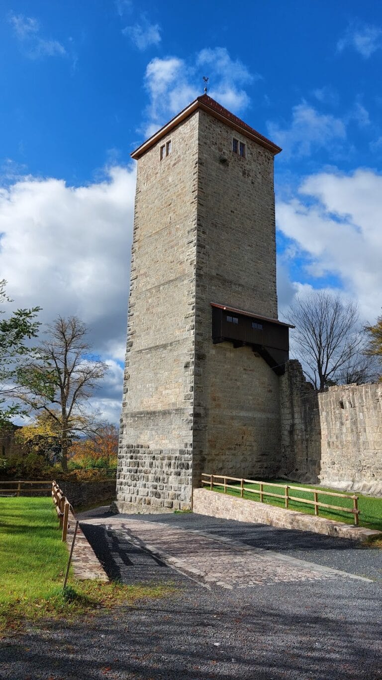
Four corner towers belong to the inner circuit. They rise about 25 metres and stand roughly 66 metres apart. The eastern pair is round, while the western pair is rectangular. A round bastion occupies the center of the northern inner wall. At the southwest corner of the outer wall stands a fifth surviving defense tower. A sixth tower once occupied the southeast corner, but it disappeared with the adjoining section of the east wall. Its foundations were found during construction work in 1911.
Schulglockenturm
The round Schulglockenturm stands at the southeast corner of the inner wall. Its shaft dates from 1417 and 1418, while the upper tower room and attic were added after 1426. The tower has five storeys, a high entrance on the second floor, and a height of 26 metres. Its diameter exceeds five metres, making it the defensive tower with the largest diameter in the complex. It formerly housed the school bell.
Achtlöchrige Turm
The rectangular Achtlöchrige Turm occupies the northwest corner. It is 22 metres high and has six storeys. The lower five are solidly built of rubble stone, and each contains a room reached by ladder. The lower levels date from 1417 and 1418. An inscription gives 1666 for the completion of the half-timbered upper room, whose walls were renewed in 1935. The tower’s name refers to the eight windows in that upper storey.
Waagglockenturm
The Waagglockenturm stands at the southwest corner of the inner wall. It has a rectangular plan measuring about 4.5 by 4.8 metres, rubble-stone lower storeys, and a half-timbered upper third with a bell bay and an octagonal roof. Its original construction date is unknown, but its tower room and roof date from after 1436. The six-storey tower reaches 26.5 metres, making it the highest tower in the Kirchenburg.
The tower formerly contained the town scales. In 1618 it had a clock with an iron mechanism that struck a bell every hour and displayed the time on a large dial. The bell also served as a fire alarm and signaled that the scales were available, which led to the earlier name Schlagturm. It hangs in an opening renewed in 1739. The tower can be climbed as a lookout tower.
Pulverturm
The round Pulverturm is integrated into the northern and eastern inner walls. It is 16.5 metres high and about 4.5 metres in diameter. Its three masonry storeys show visibly different rubble-stone structures, and the tower is reached by a wall walk. A town account from 1642 called it a powder tower, although its name does not establish that gunpowder was stored there. The construction date is unknown, and the tower was reportedly rebuilt in 1664 after damage during the Thirty Years’ War.
Wächterturm
The round Wächterturm, also called the Zwingerturm, stands near the Waagglockenturm at the southwest corner of the outer wall. It is the only surviving tower on the outer perimeter. The tower is 11.75 metres high and has three storeys, a basement, a later half-timbered upper storey, and an octagonal tented roof. A wooden stair leads to the upper entrance. Inside, another stair reaches two small rooms and a larger room used for sleeping and living quarters.
Fire and night watchmen lived in the tower from the seventeenth to the nineteenth century. During part of the twentieth century it was also known as the Kißlingsturm, after a resident named Kißling.
Gaden and Cellars
The Steingaden was attached to the defensive wall in 1466 and 1467. Built of rubble stone, it has two round-arched portals and several slit windows. Alterations were made in 1560 and 1664. Together with the other storage buildings, it forms part of the enclosed domestic and defensive infrastructure around the church.
Sixty-six vaulted cellars and 72 gaden stand mainly along the inner side of the inner wall, with additional buildings in the northern and eastern sectors. The gaden have one or two storeys and are reached through narrow lanes and stairways. Most consist of masonry cellars covered by barrel vaults and topped by hut-like superstructures. Their lower floors are generally made of rubble stone, while the upper floors use half-timbering.
Door inscriptions and dates place some of the gaden in 1547, 1575, 1576, 1855, and 1864. Repeated alterations and extensions produced uneven ridge heights and varied roof coverings. Later conservation partly standardized their appearance. The buildings retain the accumulated form of structures repeatedly adapted to changing household and storage needs.
The cellars south of the church are partly vaulted and partly cut into rock, extending beneath the southern zwinger. Their nearly constant seasonal temperatures helped preserve stored goods. Wine and fruit were kept in the dark lower spaces, while hay and grain occupied the upper floors. Other provisions included must, root vegetables, fruit, wine, and, from about 1780, potatoes. Some cellars continue to be used by local residents for storage.
Church and School Building
The church occupies the center of the fortified enclosure. It is a rectangular Renaissance building with three naves beneath a gable roof. Its exterior walls were originally finished with regular ashlar plaster. The east tower rises above both the nave and the fortification towers. It has pointed-arch windows and one of the region’s early Welsh hoods, a bulbous curved roof characteristic of Renaissance and early modern Central European architecture.
The west gallery was rebuilt several times and renewed according to its historical form in 1975. Galleries along the north side and at the rear are arranged one above another and face the pulpit, which features the four Evangelists. Including the galleries, the church provides seating for approximately 1,000 people.
The south entrance, dated 1616, has rich Renaissance decoration. The east portal dates from 1615 and incorporates an obelisk. Gray-painted scenes around the south-wall windows represent divine love, faithfulness, and care, together with Cain and Abel, David, and Goliath. Tombstones are fixed to the walls, and their arrangement was revised between 1961 and 1975. A crypt beneath the choir contains the burial of a Baron von Stein.
A large wooden barrel vault carries a ceiling painting made directly on the wood in 1619 by Nicolaus Storant of Meiningen. It depicts God’s heavenly throne as described in chapters 4 and 5 of Revelation, the final book of the Christian Bible, whose central vision includes a heavenly throne.
A stone offertory box made by Hans Markert dates from 1619. The older bells were remelted during the Thirty Years’ War, and two replacements were cast in 1645 by itinerant bell founders from Lorraine. One bears the town arms. The other names Ostheim’s two clergymen and the donor. The large bell broke in 1714 and was recast by Mattheus Ulrich, who added the names of the reigning Duke of Saxony, officials, and clergymen.
Johann Ernst Döring built the choir organ in 1738. It has two manuals, a pedal, and 37 stops. From 1894 to 1975 it stood on the enlarged west gallery. When it returned to the choir in 1975, two side tower structures dating from 1894 were removed from its case. The case was restored to its earlier colors and gilded. It bears the ducal Saxon arms, held by two gilded lions and topped by a Zimbelstern. Beneath the arms is a movable-armed trombone angel that places a trumpet at its mouth when the Trompete 8′ register in the Hauptwerk is engaged. The large foliate surrounds were newly carved, and the choir organ can also be played from the main organ.
Beside the gatehouse stands the former churchyard school. It was a Latin school in the sixteenth century and later became a girls’ school. The teacher’s apartment occupied its half-timbered upper floor. Used as a school from at least the middle of the sixteenth century, the building was rebuilt several times during the nineteenth century and fundamentally renovated around 1980. It now houses a natural-history museum and changing exhibitions.