Gubkiv Castle: A Renaissance Fortress in Ukraine


Site at a Glance
- Rating
- 4.7
- Popularity
- Low
- Country
- Ukraine
- Primary era
- Early Modern
- External website
- Open
- Eras represented
- Medieval, Early Modern
- Civilizations
- Grand Duchy of Lithuania, Polish–Lithuanian Commonwealth
- Site type
- Military
- Remains
- Castle
On this page8 sections
History
Gubkiv Castle is a ruined fortress near Hubkiv in Ukraine, developed from an earlier wooden castle and settlement and later rebuilt as a stone fortress with Renaissance characteristics. Archaeological finds indicate that the first settlement occupied the site between the tenth and thirteenth centuries, before the Mongol-Tatar invasion destroyed it. A stone fortress is attributed to the fifteenth century, while a later Renaissance phase dates to 1613.
Early fortress and the Siemaszko family
The castle and nearby settlement were destroyed by the Tatars in 1504, along with the church near the fortress. From the beginning of the sixteenth century, Gubkiv belonged to the magnate Siemaszko family. The first known owner from the family was Bohdan Mykhailovych, the Kovel starosta, an official who administered a district or royal estate. He died in 1545.
His son Aleksander Siemaszko became a prominent Volhynian landowner. He distinguished himself in the 1537 Battle of Dubno and, with the support of the Jesuit Benedict Herbest, became one of the first Volhynian nobles to convert to Catholicism. Acts from January and March 1596 identify Gubkiv as Aleksander’s estate. At that time he held the offices of Bratslav castellan, a senior territorial official, Lutsk starosta, and Vladimir subchamberlain, an administrative officeholder.
Revolt, inheritance, and municipal life
Other records from 1596 state that troops led by Hryhoriy Loboda captured the castle during the Nalivaiko uprising, a Cossack and peasant revolt in the Polish-Lithuanian Commonwealth. By 1629, the fortress was held by Stanislaw Daniłowicz, who was married to Maryna, daughter of Mikołaj Siemaszko, described as the last Siemaszko owner of the castle.
Ownership later passed from the Daniłowicz family to the Cetner family. Jan Cetner received the estate as Maryna’s dowry in 1676, and it subsequently passed through a family settlement to Teofila, the wife of Józef Felicjan Potocki. During the Daniłowicz and Cetner periods, the castle had its own burgomaster, the head of the town government, and municipal councillors. It remained inhabited until 1708.
Destruction and later protection
Gubkiv suffered severe damage during the Northern War, the European conflict of 1700 to 1721 involving Sweden, Russia, and other powers. In 1704, troops of Peter I damaged or destroyed the settlement and its castle while passing through the area. Swedish troops destroyed the castle in 1708, after which it was not rebuilt. The Potockis moved to nearby Siedliszcze, where they built a new residence, while the ruins continued to deteriorate.
Archaeological work in 1974, led by the Soviet Ukrainian archaeologist Y. M. Nikolchenko, identified evidence for the early wooden castle and settlement. Gubkiv Castle is protected in Ukraine as an archaeological monument of local significance, and the castle hill forms part of the Nadsluchanskyi Regional Landscape Park, a protected area conserving landscape and natural and cultural features.
Legends and the natural landscape
Several traditions surround the castle and its surroundings. One persistent story claims that a subterranean passage linked the castle with the Orthodox male monastery at Marynin. The passage was supposedly used first by the Siemaszkos and later by the Daniłowicz owners. It was said to begin at the castle well and pass beneath the Sluch River, crossing more than 10 kilometres of granite terrain.
Local legends connect the 1504 destruction with Tatar Mound, believed in tradition to have been a Tatar camp on an island among marshes. One version tells of a hunter’s sorceress wife who showed the Tatars the route to Gubkiv and later drowned in a marsh called Babine Halo. Villagers then believed that she appeared to them seeking forgiveness. Another version says that the Tatars followed church bells toward the town but failed to capture the church on high ground.
A further tale concerns a prince’s daughter who loved a commoner from the opposite bank of the river. Imprisoned in the highest tower, the pair supposedly became falcons at night. After the prince cursed them, they remained birds, giving their name to the nearby Falcon Mountains.
Other traditions place underground treasure near the castle and attribute it to Siemaszko princes, although the same tradition acknowledges that no such princes are historically attested and may confuse the Siemaszkos with the Sanguszko family. Treasure seekers reportedly attacked the walls with picks and crowbars about a century ago, but whether they found anything is unknown. Another legend places the ceremonial mace of Hetman Bohdan Khmelnytsky near the castle or the Falcon Mountains. A hetman was a senior military commander, and the mace represented military and political authority. According to the story, the weapon is guarded by the souls of fallen Cossacks until a worthy bearer appears.
Traditions concerning nearby Dzvonetska Hill describe the supposed sound of buried bells, swords, and dying warriors heard by placing an ear to the ground in sunny weather. An old grave on the hill is marked by a large stone cross that now leans with age. Another legend attributes the grave to Tatars and wounded soldiers supposedly buried there after the events of 1504.
The landscape around the castle also became associated with unusual plants. In 1795, the Irish landscape architect and botanist Dionisius McClair reportedly found Pontic azalea near the fortress. Its presence was considered unexplained because the nearest stated natural range was in the Caucasus. Nineteen rare plant species listed in red books occur on Dzvonetska Hill, including meadow sage and mountain onion, while ten orchid species have been recorded in forests near the castle and the Falcon Mountains. Local traditions explain the flora as seeds carried on the hooves of Mongol-Tatar horses or planted by a khan’s daughter longing for the steppe. In the nineteenth century, the French company Coty reportedly collected Pontic azalea flowers in Polesia to produce an extract called “Absolu” for high-quality perfume.
Remains
Castle hill and defensive enclosure
The ruins occupy a castle hill about 30 metres above the right bank of the Sluch River. The steep slope separates the hill from other buildings. The fortress had an approximately trapezoidal plan and belonged to the Volhynian tradition of defensive complexes. Its stone walls enclosed four corner towers, each with loopholes, narrow openings for weapons. An entrance gate and drawbridge completed the defensive arrangement.
During the period of Mikołaj Siemaszko, the castle reportedly extended across two opposing hills connected by a bridge. Defensive walls and towers or projecting fortified structures with loopholes enclosed the complex. By 1879, descriptions identified fragments of towers, sections of the perimeter walls, visible loopholes, and traces showing the arrangement of the chambers. One eastern tower was then said to be the highest and retained both storeys, although its roof had disappeared. By the late nineteenth century, parts of the towers, defensive walls, and residential rooms remained visible.
Courtyard, well, and underground spaces
The courtyard contained residential and utility buildings together with a deep well lined with stone. The well has since been filled in, but its position remains visible on the castle hill. Cellars and a prison lay beneath the buildings. Extensive masonry chambers below ground may have formed a passage toward the river, a feature that helped sustain the tradition of an underground route to the monastery at Marynin.
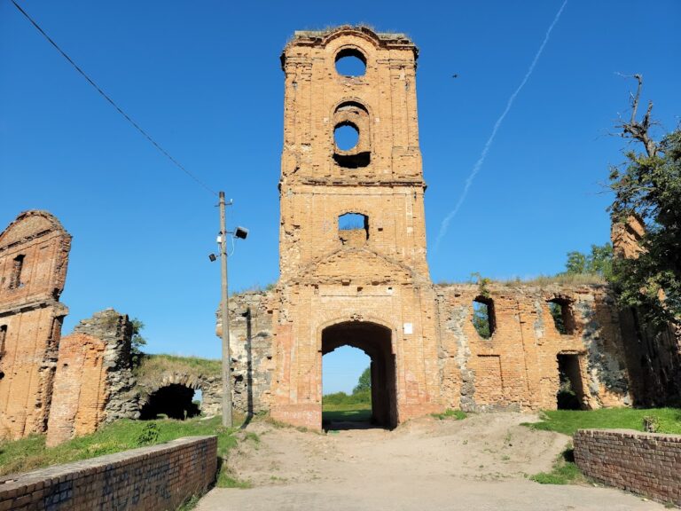
Only sections of the walls and several towers survive. The visible ruins and the filled castle well remain on the castle hill, while most of the former fortress complex has disappeared.
Nearby sites