Gräpplang: A Bronze Age Settlement and Medieval Castle in Switzerland


Site at a Glance
- Rating
- 4.8
- Popularity
- Very Low
- Country
- Switzerland
- Primary era
- Medieval
- External website
- Open
- Eras represented
- Medieval, Early Modern, Modern
- Civilizations
- Holy Roman Empire
- Site type
- Military
- Remains
- Castle
On this page10 sections
History
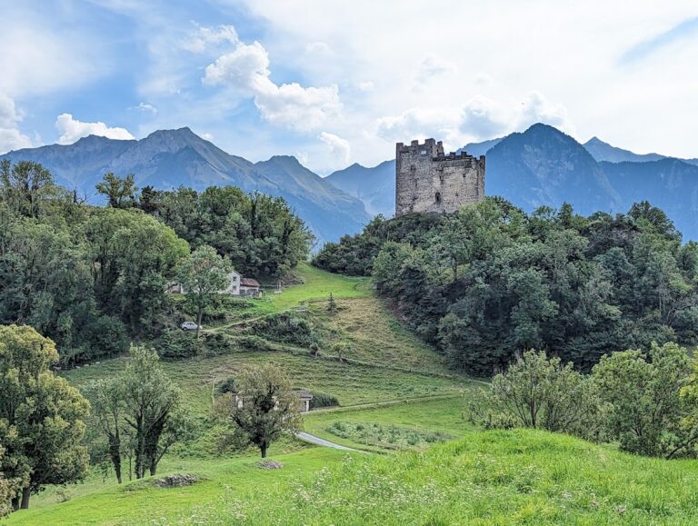
Gräpplang is a prehistoric and Bronze Age hilltop settlement and medieval castle in Switzerland, above Flums in the Seez valley. The medieval fortification was built around 1220 by the Knights of Flums, administrators of the episcopal estate of Flums on behalf of the Bishopric of Chur. Built on a rocky spur above an old route linking Zurich with the Grisons via Lake Walenstadt, the castle controlled an important passage through the region.
Prehistoric settlement and medieval foundation
People inhabited the hilltop before the castle was constructed, as shown by finds from several periods and by archaeological investigations. The Bishopric of Chur originally owned the site. The bishopric was an ecclesiastical principality whose bishops exercised both religious and territorial authority, with local estates administered by appointed officials.
Gräpplang first appears in written records in 1249, when the Bishopric of Chur granted Castrum Flumius to Heinrich von Flums. From the fourteenth century, the name appears as Crepalla, while Gräpplang became the established form around 1500. From the late thirteenth century, the episcopal lordship of Flums was pledged several times. In 1292 it was pledged to Ulrich von Flums. Between 1419 and 1458, it was held by the city of Zurich and by the families of Montfort, Stadion, Hertenegg, and Schauenstein.
War, administration, and changing ownership
During the Old Zurich War, a conflict between Zurich and opposing Swiss Confederacy allies from 1436 to 1450, Glarus and Schwyz demanded protection money from Gräpplang in 1440. The castle was not attacked or destroyed. A bishopric-appointed bailiff, Ulrich von Grünenberg, was again recorded at Gräpplang in 1460.
In 1528, while Bishop Paul Ziegler was absent after fleeing the country, the League of the House of God sold the outlying Flums property to Ludwig Tschudi of Glarus for 2,400 Rhenish guilders. The League was one of the Three Leagues, a regional political alliance in what is now the Swiss canton of Graubünden. Ludwig Tschudi was the brother of the chronicler Aegidius Tschudi. The Tschudi family retained Gräpplang until 1767, and twelve members of the family are documented as lords of the castle.
Alteration, decline, and conservation
Under Josef Anton Tschudi, the complex was substantially changed around 1700. The enclosing wall of the outer bailey was closed, the defensive passage known as the zwinger was moved and redesigned, a second cistern was built, and the approach to the main castle was lowered. The eighteenth-century building work was poorly executed and created expensive maintenance problems.
The Tschudi family sold Gräpplang to the Good family in 1767. The Good family appears to have made little or no residential use of the increasingly deteriorated castle. In 1804, the complex was sold to Josef Eberli of Flums for demolition. During the following decades, stone from the castle was reused to repair buildings in the surrounding area, and roof tiles were used to repair the church at Vilters.
Conservation began in the twentieth century. Emil Grünenfelder acquired the ruins in 1909 and resold them in 1912 on the condition that they would not be demolished. The local tourism association carried out initial repairs from 1914, and the municipality of Flums took over the ruins during the 1920s. Comprehensive conservation followed in 1990 and 1991. In 1998, narrow stairs and walkways were installed inside the palas, the principal residential and representational building of a medieval castle. The system was designed by the Haldenstein-based architect Michael Hemmi and the Chur engineers Conzett Bronzini Gartmann. Gräpplang is recognized as a Swiss cultural property of national significance and is regarded as a heritage site of national importance.
Remains
Gräpplang occupies a rocky spur at approximately 450 metres above sea level, with steep drops to the north and east. Its elongated layout has a western main castle and a somewhat lower eastern outer bailey, an external castle area for secondary buildings and working facilities. A transverse ditch separates the two parts. The outer bailey and its service buildings were added later than the main castle, and the site survives as a ruin.
Main castle
Keep and courtyard
The keep stands in the eastern part of the main castle. To its north-east lies the castle courtyard, which contains a cistern, a reservoir for collecting and storing water. The courtyard was later transformed into a five-storey residential palas with a trapezoidal plan and several rooms.
Chapel and palas windows
A vaulted room on the upper storey at the eastern side of the palas served as a chapel. The altar base and sacristy room remain identifiable. Over the centuries, many windows were enlarged into broad pointed-arch openings, whose apexes are formed by two meeting curves. Traces of earlier trefoil windows, with openings formed by three rounded lobes, survive alongside remnants of the original lime plaster on the façade.
Approaches and entrance
The southern approach to the palas is protected by a zwinger, an enclosed defensive area between fortifications. The zwinger could be reached only by a bridge across the ditch separating the outer bailey from the main castle. The current route to the zwinger and palas probably dates from the sixteenth century. An earlier approach followed a narrow rock ledge to a high entrance that could be reached only by ladder.
The gate leading to the castle courtyard retains holes for the crossbars that secured the entrance. These fittings remain part of the surviving evidence for how access to the main castle was controlled.
Outer bailey and service buildings
The eastern outer bailey retains visible service buildings attached to the enclosing ring wall, which surrounded the hill. The kitchen has also been identified. The arrangement reflects the working facilities of the later castle area, while the closed ring wall, relocated zwinger, second cistern, and lowered entrance route preserve elements of the alterations made around 1700. Internal stairs and walkways installed in the palas during later conservation allow the surviving rooms and architectural details to be reached within the preserved ruins.