Galata Tower: Genoese Watchtower and Istanbul Landmark



Site at a Glance
- Rating
- 4.6
- Popularity
- Very High
- Country
- Turkey
- Primary era
- Medieval
- External website
- Open
- Eras represented
- Medieval, Early Modern, Modern
- Civilizations
- Genoese, Ottoman
- Site type
- Military
- Remains
- Tower
On this page19 sections
History
Galata Tower is a Romanesque stone tower in Türkiye, standing in the former Genoese colony of Galata in Istanbul. Built in 1348 during the colony’s fortified expansion, it served as the principal tower of the defenses, a watchtower, and a strongpoint protecting the lower settlement and waterfront from attack by land. The Genoese, a maritime trading power from the Italian city-state of Genoa, had established the colony of Pera in 1267 and later extended its fortified area toward the northeastern hill without Byzantine authorization.
Genoese foundation and Byzantine conflict
The tower was constructed within fortification works carried out between 1335 and 1349. Its position on the hill gave it a defensive role within the expanding colony. During the Genoese period it was known as the Tower of the Holy Cross, or Turris Sancte Crucis, after the cross that formerly stood at its summit.
Commercial rivalry led to war between Byzantium and Genoa in August 1348. Byzantium was the medieval continuation of the Roman Empire, centered on Constantinople. After the conflict ended with a Byzantine victory in 1349, Emperor John VI transferred control of the hill containing the tower to the Genoese. The fortifications continued to develop, including an entrance complex completed by 1 April 1452. A semicircular barbican, an outer defensive structure protecting an entrance, projected from the straight wall line before the tower, with a courtyard between them. This was the last defensive construction built at Pera before Ottoman control.
Ottoman conquest and adaptation
When the Ottoman Empire conquered Constantinople on 29 May 1453, the Genoese surrendered Pera without resistance. Sultan Mehmed II ordered that damage to the Galata defenses be halted. Under the direction of Zağanos Pasha, an Ottoman commander and senior official, damaged parts of the tower were rebuilt, the structure was raised again, and the cross at the summit was replaced by an Ottoman flag.
An earthquake in 1509 damaged the tower and other Galata fortifications. Repairs directed by the Ottoman architect Hayreddin were completed in mid-1510, when the tower was raised once more. Two brick bands in the shaft are associated with this work, although the precise extent of the earthquake reconstruction remains uncertain.
During the sixteenth century, the tower and other Galata towers housed Christian prisoners of war who were employed in the shipyards at Kasımpaşa. The tower also served as a prison. In the seventeenth century, the traveler and writer Evliya Çelebi described it first as a dungeon and later as a supply store for the imperial shipyards. The astronomer Takiyüddin also worked in the tower before establishing his observatory in Istanbul.
Fire watch and nineteenth-century rebuilding
From the eighteenth century, Galata Tower was used by the Mehterhane institution and by fire watchers. From 1717, the Ottomans used it specifically to detect fires in the city, and it later served as a communications post for the navy.
A fire on 27 July 1794 damaged the upper part. The tower was shortened, its design was altered, and projecting rooms, roofed galleries, and a reception hall were added around the top. These changes created a coffeehouse, while a large drum was installed to announce fires and the attic became a dovecote. Another fire on 2–3 August 1831 caused further damage. The upper part was then repaired in a new form, and a roof repair followed in 1853 or 1854.
The date and cause of the later removal of the conical roof remain uncertain. It may have been altered or removed around 1862, or it may have been destroyed in the storm traditionally dated to 1875. After the roof was lost, two upper storeys containing one room each were added, together with a terrace and flagpole. The summit continued to serve as a fire-reporting station for the fire brigade established in 1874 and as a naval communications station.
During the nineteenth century, the courtyard, gates, and sections of the walls leading toward the shore were demolished, while the surrounding ditches were filled. As Istanbul expanded northward, much of the Galata fortification system was dismantled, although portions of the walls survived.
Republican use and museum conversion
After the proclamation of the Turkish Republic in 1923, the tower remained in use by the fire brigade and navy. A time ball removed from the British Naval Hospital in February 1930 was installed at the summit in March and entered service in November 1934.
The upper wooden rooms were evacuated after their beams deteriorated and collapsed during the winter of 1959–1960. Restoration and conversion into a tourist facility followed. Work begun after a 1964 tender was completed in 1967, and the tower reopened ceremonially on 28 September of that year. It opened as a tourist establishment on 30 May 1969. The conversion introduced a coffeehouse, historical museum, sales areas, restaurant, kitchen, lobby, and nightclub. The tower operated under leases from Istanbul Municipality, first through the Ünal Kardeşler company and later through a company belonging to its heirs.
The exterior was restored in 1999–2000. In 2013, operation passed to BELTUR, an enterprise of Istanbul Metropolitan Municipality, and the upper two floors were used as a restaurant and café. Ownership passed to the Directorate General of Foundations in 2019 on behalf of the Kule-i Zemin Foundation. BELTUR’s lease ended on 31 December 2019, ending the municipality’s operation of the tower.
Restoration begun on 30 June 2020 removed interior fittings and decorative elements introduced during and after the 1960s work and addressed the interior and exterior. The tower reopened on 6 October 2020 as the Galata Tower Museum. Its exhibitions cover the tower’s observatory period, the reported flight of Hezârfen Ahmed Çelebi, the Turkish War of Independence, the Galata fortifications, and the history of Galata Tower and Istanbul. Roof restoration began on 1 November 2023, including measures to reinforce masonry and reinforced-concrete elements and improve earthquake resilience. The tower reopened on 25 May 2024.
Cultural interpretation and heritage status
Evliya Çelebi recorded a tradition that Hezârfen Ahmed Çelebi flew from the tower toward Doğancılar in Üsküdar using artificial wings. The episode’s historical authenticity is uncertain, but it became an important part of the tower’s cultural interpretation and is represented in the museum.
Galata Tower has long functioned as a symbol of Beyoğlu and Istanbul. Its exterior and surrounding area have been illuminated or used for projections, commemorations, awareness campaigns, celebrations, protests, and other public events. Galata Tower and its surroundings became a tourism centre in 1989 and a renewal area in 2006. Parts of Beyoğlu were designated an urban conservation area in 1993. In 2013, the tower was added to Türkiye’s UNESCO Tentative World Heritage List as part of the serial nomination “Fortresses and Walled Settlements from the Mediterranean to the Black Sea along the Genoese Trading Route.” This list identifies sites considered suitable for possible future nomination and does not constitute World Heritage inscription.
Remains
Stone tower and lower levels
Foundation and entrance
Galata Tower is a cylindrical masonry structure built chiefly of stone on rocky, clay-bearing schist ground approximately 35 metres above sea level. Its massive stone foundation supports a shaft whose architectural height to the roof tip is 62.59 metres. The ground floor covers 208 square metres, with an exterior diameter of 16.45 metres and an interior diameter of 8.95 metres. The walls are approximately 3.75 metres thick up to the fourth level and about 3 metres thick above it. Including the basement, ground floor, and mezzanine, the tower has eleven levels.
The entrance lies on the southern axis above ground level and is reached by marble steps on both sides. Its portal has Empire-style mouldings. Above it, a marble inscription commemorates the repair and restoration of 1831–1832 with a poem by Pertev. Nuri Dede carved the sixteen-line text in relief using the celî talik script, arranging it in four panels that include the phrases “Ya Hafiz,” “Mashallah,” and “Ya Rafi.” A monogram of Sultan Mahmud II formerly included in the inscription was erased after the proclamation of the Republic.
Basement and vaulted gallery
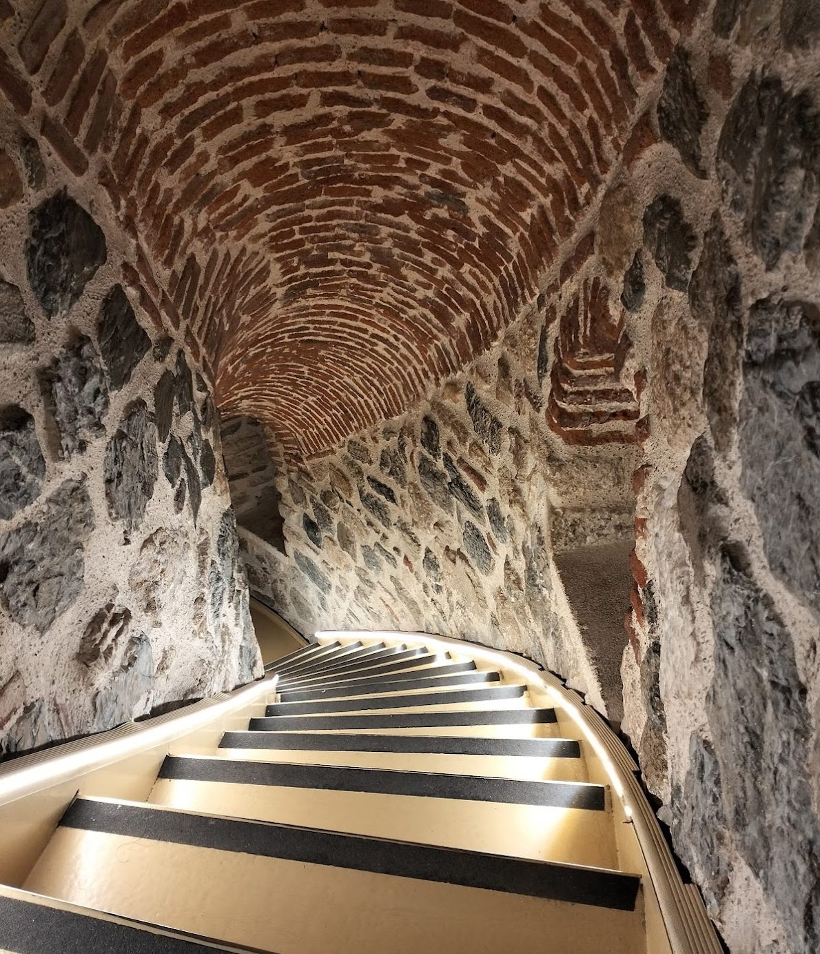
Investigations in the 1960s reached 4.3 metres below ground without finding a floor. The area was emptied for foundation reinforcement, creating a basement 3.8 metres below ground level. A reinforced-concrete stair, concealed by a circular floor panel, connects it with the ground floor. The first four levels are linked by a vaulted gallery built into the tower. Brick vaults and stone stairs survive there, with timber surfaces protected by epoxy.
The ground-floor stairway to the upper levels has twenty-two steps. It is 80 centimetres wide and 150 centimetres high, and sits 42 centimetres inside the inner wall. The entrance level has a ceiling faced with hexagonal natural stone. Two lifts, each designed for eight people, stand opposite the entrance. Their walls and ceilings display videos filmed from the tower. The mezzanine begins 4.45 metres above ground and has reinforced-concrete construction with Empire-style railings.
Masonry and defensive openings
Lower shaft
The first level begins at 8.97 metres. Its window openings measure 20 by 45 centimetres externally and 200 by 180 centimetres internally. The second level begins at 13.20 metres and has similar characteristics, although its interior diameter narrows to 8.85 metres. The lower shaft has irregularly arranged loopholes and a slight flattening on the southern side. From the fourth level upward, the shaft becomes fully cylindrical and its loopholes are more regular.
Brick bands occur at heights of 13.20 metres, at the beginning of the second level, and 17.17 metres, at the beginning of the third. Below the first band, the wall consists of roughly dressed blocks of dark yellow, light brown, dark grey, and dark blue stone mixed with brick fragments. Above it, the stones are smaller, more finely dressed, generally horizontal, and mostly rectangular, with limestone predominating.
Upper defensive levels
The changes in masonry indicate that earthquake damage reached at least the exterior up to the second level, while the thick-walled shaft and vaulted internal gallery survived to a considerable extent up to the fourth. The brick bands may have helped distribute loads between repaired sections and the earlier walling. An Ottoman-style brick ornament appears on the southern side of the second band. Crossing cracks at its joints indicate that the upper section traditionally attributed to the Genoese may contain at least two building phases.
The third-level walls contain niches with chimney-like features that the architect and architectural scholar Köksal Anadol compared with those of the Zağanos Pasha Tower at Rumeli Fortress. The fourth level begins at 20.80 metres and contains fourteen rectangular windows. Its vaulted gallery faces south, toward the former colony, while the wall most exposed to attack retained its full thickness. At this level the interior diameter expands to 10.4 metres.
The fifth level begins at 24.35 metres and has fourteen windows. Seven are circular openings, each 35 centimetres in diameter and intended for cannon fire. The other seven are pointed-arch windows measuring 115 by 180 centimetres. Externally, all are set within niches formed by brick-arched piers. The sixth level begins at 27.90 metres and contains fourteen smaller pointed-arch windows.
Summit levels and roof
Pavilions and terrace
The seventh level begins at 32.60 metres and contains a summit pavilion. Fourteen windows are formed by thirteen masonry piers measuring 120 by 225 centimetres, spaced 150 centimetres apart and connected by arches. The eighth level begins at 40.04 metres, has an internal width of 12.40 metres, and extends to approximately 50.5 metres. Its fourteen windows are formed by piers measuring 110 by 100 centimetres, spaced 170 centimetres apart and aligned with those below.
A terrace 1.20 metres wide runs around the exterior of the eighth level, where the differing sections of the two storeys create a ledge. Fourteen masonry balusters stand on the axes of the interior piers. Each carries a stone sphere 35 centimetres in diameter, secured with an anchor. Iron railings 110 centimetres high connect the balusters and have Empire-style ornament. Steel stairs installed during the twentieth-century restoration connect the sixth, seventh, and eighth levels.
Conical roof and later alterations
The present conical roof is reinforced concrete covered with lead. Four windows face the cardinal directions and reach a height of 50.29 metres. A gilded-bronze finial rises above the roof. Its height is given as either 7.41 metres or 6.75 metres, and a 50-centimetre lantern with a flashing red light and lightning conductor is mounted above it.
After the 1794 fire, the roof and upper storeys were rebuilt, the tower was shortened by approximately 1.9 metres, and an Empire-style pavilion with glazed projections about 1.5 metres long was added. Following the 1831 fire, the projecting sections were replaced by a gallery with fourteen semicircular-arched windows, above which stood a smaller windowed level and an iron-railed balcony. Later nineteenth-century work added two octagonal timber-and-masonry levels and a terrace at approximately 51.65 metres, with a flagpole above. The former spiral stair between them was replaced by a straight wooden stair inclined at 45 degrees.
During the 1965–1967 restoration, timber floors were replaced with reinforced-concrete floors, surfaces were generally faced with natural stone, and the stair treads were clad and illuminated. Wall cracks were repaired, and reinforced-concrete elements strengthened the structure. The roof was reconstructed as a less sharply pointed lead-covered form resembling the design associated with 1832–1876, with a gilded-bronze finial. A relief reproducing Matrakçı Nasuh’s depiction of Galata was installed above the ground-floor lift entrance.
Fortifications and museum interior
Surviving defensive setting
The original fortification included a wooden bridge that could be removed when necessary and provided passage between the city side and the area beyond the ditches. The former barbican survives only in remains, while sections of the Galata walls remain near the tower. The Bereketzade Fountain, moved from its former location in 1957, stands beside the surviving wall remains facing the tower square. A plaque installed on the southern exterior in 1953 commemorates the surrender of Galata to Mehmed II on 29 May 1453 and its completion on 1 June.
A brick-vaulted channel opens on the entrance axis. It measures 72 by 150 centimetres and lies 4.2 metres above ground. It may once have continued beyond the tower beneath the walls and connected parts of the fortifications, although that interpretation remains uncertain. Historical depictions vary. A map copied in the 1420s or 1430s shows a conical roof, a projecting upper level with a blind arcade, and a tower taller than the surrounding towers. Another map, dated 1485–1490, shows a Genoese flag. A 1537 miniature by Matrakçı Nasuh depicts a summit pavilion, an upper storey, and approximately eight openings in the pavilion.
Exhibition levels
After the 2020 restoration, the interior walls and ceilings were coated with plaster. The ground floor contains ticket control, security, and the lift entrance. The first floor is a museum shop. The second presents a simulation of Hezârfen Ahmed Çelebi’s reported flight and an exhibition on the tower’s observatory period. Permanent displays on the Turkish War of Independence, the Galata walls and tower, and Galata and Istanbul occupy the third through fifth floors.
The sixth floor serves as a transition area. The seventh is a temporary exhibition level containing a 1:2,500-scale model of part of Istanbul and viewing binoculars at the windows. The eighth level forms an observation terrace with benches. The tower’s physical setting also includes the surviving wall fragments, the Bereketzade Fountain, and the surrounding square, whose surfaces have been used for temporary commemorative lighting and projected images.