Fort of São Francisco do Queijo: Porto’s Coastal Fortress


Site at a Glance
- Rating
- 4.4
- Popularity
- Medium
- Country
- Portugal
- Primary era
- Early Modern
- External website
- Open
- Eras represented
- Medieval, Early Modern
- Civilizations
- Portuguese
- Site type
- Military
- Remains
- Fort
On this page9 sections
History
The Fort of São Francisco do Queijo, also known as Castelo do Queijo, is a coastal fortress in Porto, Portugal, rebuilt in 1643 during the Restoration Wars. It stands at Nevogilde, near the mouths of the Douro and Leça Rivers, and occupies a position that has been associated with defence since an earlier fortification was probably built there in the fifteenth century.
Early site and seventeenth-century rebuilding
The rocky area known as Queijo was considered sacred by the Draganes, a Celtic tribe said to have arrived in the sixth century. A fortification probably existed on the site by the fifteenth century, but the position was judged unsuitable in 1643. Porto’s judges and aldermen, Captain António Pires Picão, and commanders of several carracks and caravels argued that the rocky coast and strong tides offered no safe place for landing.
King John IV therefore ordered a new fort in 1643. The French military engineer Miguel de l’Ècole designed it, while Fernando César de Carvalhais Negreiros, Captain of the Royal Armada, directed the work. Friar João Turriano, the Kingdom’s engineer, recommended moving the fortification farther away to Pedra do Queijo and reusing material from the earlier structure. Porto paid for the rebuilding during the Restoration Wars, the seventeenth-century conflict in which Portugal recovered its independence from the Spanish Habsburg monarchy. Fear of attacks by Spanish fleets was central to the decision to reconstruct the fort.
Eighteenth-century garrison
In 1717, Porto asked King John V to decommission the fort because its upkeep placed a heavy strain on municipal finances and the fortress was regarded as unnecessary. The King’s Council of War rejected the request and kept it in active service. A private chapel was built in 1751 for officers serving at the fort. On 11 April 1758, its garrison consisted of a lieutenant acting as commander, a constable, a sergeant, and 11 artillerymen. Soldiers from the Porto regiment could be sent there when necessary.
Declining military role and civil conflict
By 1804, the fort no longer met the tactical requirements of the period, and its military usefulness had declined. It was not used defensively during the French invasion of Portugal between 1807 and 1811.
The fort returned to military importance during the Siege of Porto in 1832–1833, part of the Portuguese civil war between the Miguelists, who supported King Miguel I, and the Liberals, who supported Queen Maria II and constitutional government. Miguelist forces occupied the fort and extended their position as far as Lordelo while facing opposing batteries and the Liberal navy. The fort was destroyed by the end of the civil war.
In 1839, the site was assigned to the Veterans Company. During the Maria da Fonte revolt in 1846, troops belonging to the Junta of Porto occupied it, and the frigate Íris bombarded the fort in support of the government of Queen Maria II. Between 1890 and 1910, the Guarda Fiscal, the Portuguese state force responsible chiefly for customs and fiscal enforcement, held the site.
Twentieth-century reuse and protection
The fort became a Property of Public Interest in 1934, a Portuguese legal category for protected heritage. In 1938, Porto’s Municipal Commission for Art and Archaeology proposed adapting it as a museum. Restoration work followed in 1942.
After another period of abandonment, the fort was reactivated in 1943 during the Second World War, when anti-aircraft batteries were installed because of fears of German attacks. Its doors were opened to the public to help raise funds for a permanent guard. Nevogilde parish authorities installed services there in April 1944, although the General Directorate for Public Finances later ordered the removal of their equipment. The parish authorities still maintained installations at the fort in 1949, sharing the spaces with a naval brigade of the Portuguese Legion until 25 April 1974. Northern commandos occupied the post between 1977 and 1978.
The fort was included in a Special Protection Zone in 1961, another form of Portuguese heritage protection. In 2008, the northern regional cultural authority proposed incorporating it into the protected maritime promenade and Avenida de Montevideu designation. The consultative council of IGESPAR, Portugal’s former national institute for architectural and archaeological heritage management, accepted the proposal on 7 January 2009.
Remains
Fortifications and outer layout
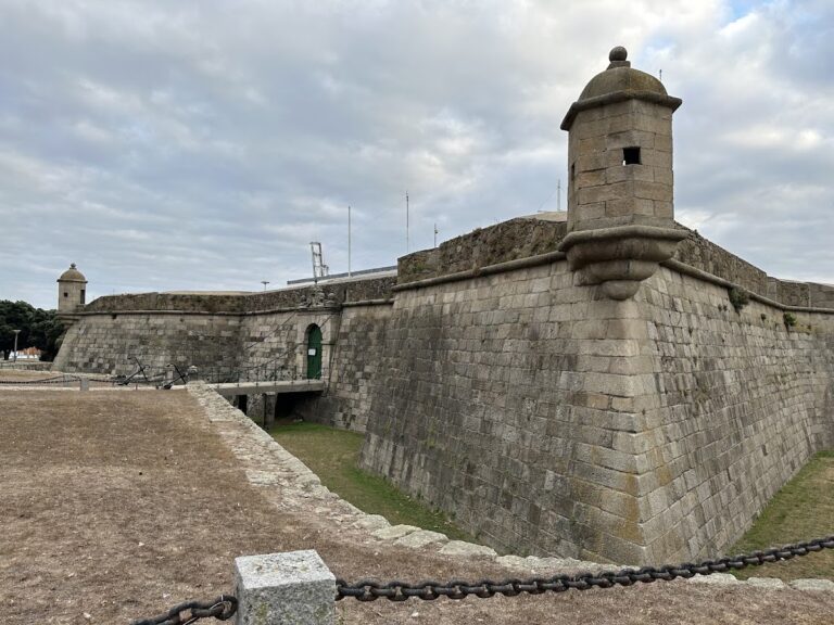
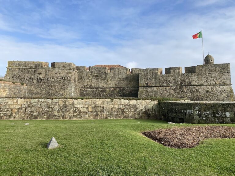
The fort occupies a cliff above the ocean, a short distance from the mouths of the Douro and Leça Rivers. Porto’s city park lies to the northeast and is directly connected to the sea. The fortress has a trapezoidal plan, with high granite walls arranged in regular sloping courses. A dry moat surrounds the structure, together with areas that are inundated at high tide.
The walls are topped by a rounded frieze and irregular battlements. Pentagonal facades contain watchtowers set on stepped triangular corbels made from logs. Cornices support the towers, whose molded rounded domes are placed against the corners. These surviving elements define the fort’s defensive outline above the rocky coast.
Main gateway and entrance tunnel
The southeast-facing facade contains the principal gateway, formed by a rounded arch. A wooden drawbridge, supported on corbels, provides access to the entrance. Above the gateway is Portugal’s coat of arms, crowned and placed below a granite sphere. Vertical grooves beside the relief have an iron frame from which the drawbridge chains hang.
The drawbridge leads into a small tunnel divided into two spaces, with traces of doors. Its barrel-vaulted ceiling and three arrow slits on each side belong to the defensive entrance arrangement. A bronze plaque with an inscription stands on the left side of the tunnel entrance. A rounded granite niche there contains a stone representation of Saint Francis Xavier, while a matching niche on the right holds an image of the Virgin Mary.
Courtyard and internal buildings
The tunnel opens onto a courtyard covered by metal grilles and glass plates. From this space, access leads to a bar, a barrel-vaulted powder magazine, stairs, balconies, and gateways opening into the remaining rooms. A ramp from the entrance lobby reaches the upper deck.
An 1860 plan recorded the drawbridge, the governor’s residence, a ruined chapel, ruined accommodation for officers and soldiers, a ramp to the esplanade, the moat, areas flooded by the sea, four soldiers’ quarters, a kitchen, a powder magazine, and a vaulted accommodation building. An oratory dedicated to Saint Francis Xavier stood in the hall of the former commander’s residence.
Nearby sites