Dunskey Castle: A Ruined Scottish Tower House on the North Channel


Site at a Glance
- Rating
- 4.6
- Popularity
- Low
- Country
- United Kingdom
- Primary era
- Early Modern
- External website
- Open
- Eras represented
- Early Modern
- Civilizations
- Kingdom of Scotland
- Site type
- Military
- Remains
- Castle
On this page8 sections
History
Dunskey Castle is a ruined tower house in Scotland, United Kingdom, near Stranraer, built by the Adair family of Kinhilt during the late medieval and early modern period. The present building developed through major rebuilding in the early sixteenth century on a site associated with an earlier castle, traditionally dated to the twelfth century. A medieval fortification existed there by no later than the fourteenth century, although it may have been demolished before the current tower house was built. The castle now forms a nationally important archaeological and historic site protected as a scheduled monument.
Medieval lordship
In the 1290s, Walter de Corry, described as laird of Dunskey, was connected with the administration of nearby Wigtown Castle, then held by Edward I of England. It is uncertain whether Dunskey Castle had already been built at that time. Walter died by 1303, after which his lands passed into the king’s hands.
Charters from about 1326 associate Thomas Edzear, or Adair, with lands at Kildonan and Portrie in the Rhinns. Portrie is identified with the later Dunskey and Portpatrick area. By about 1426, Nigello Adare of Portrie, identified with Dunskey, witnessed the restoration of lands at Lochnaw. The estate of Kinhilt, including Dunskey, was linked with Gilbert Kennedy of Dunure in the mid-fifteenth century, although records differ over whether he actually held its ward, the system by which control of a minor’s estates was assigned to another person.
In 1486, the ward of the lands of the deceased Rolland Adair, including Kilhelt, Portre, Kildonan, and Drummore, was said to have been incorrectly held by Alexander Bruce for eighteen years. In 1488, William Adair of Dunskey and Kinhilt and McCulloch of Ardwell were attacked by Quentin Agnew, sheriff of Wigtownshire. Around 1489, Sir Alexander M’Culloch of Myrtoun partly burned Dunskey Tower House. A pardon for the burning of the Place of Dunskay followed in 1499.
Adair rebuilding
The Adairs repaired and enlarged Dunskey in the early sixteenth century. The hall was rebuilt, probably around 1520, and Ninian Adair, who inherited the estate after his father William was killed at the 1513 battle of Flodden, is said to have reconstructed the castle on a more magnificent scale. Ninian’s marriage to Janet McDowell was associated with an effort to end the feud between the Adairs and the MacDowells. The Adairs also built the Castle of St. John at nearby Stranraer around 1510.
While Ninian’s heir William was under age, control of the Adair lands, including Dunskey, was assigned in 1520 and 1521 to Gilbert Kennedy, 2nd Earl of Cassilis, and Lord Maxwell. William was recorded as Ninian’s heir by 1523. Dunskey and the lands of Portrie remained part of William Adair’s estate in 1608.
Montgomery ownership and abandonment
Hugh Montgomery, 1st Viscount Montgomery, acquired Dunskey in 1620 and expanded it with a gallery and vaults. A letter written by his wife, Sara Maxwell, in 1632 refers to continuing work and roofing on the gallery. Montgomery was still recorded as heir to the property in 1646.
Financial difficulties, partly resulting from the cost of maintaining troops, led to the transfer of Dunskey and its associated lands to the Blair family in the mid-seventeenth century. John Shaw received the property in 1653 after it had been assessed for debts, while records from 1649 identify Reverend James Blair, minister of Portpatrick, as receiving lands in the area. Dunskey was valued at £946 13 shillings and 4 pence in 1657. In 1672, John Blair and his wife Jean Agnew received ratification of their lands as the barony of Dunskey. By 1684 they had moved to nearby Killantringan, and Dunskey Castle was already described as being in ruins, about fifty years after Montgomery’s gallery extensions.
Dunskey was placed in Scotland’s highest listed-building category, Category A, in 1972, although that listing was removed in 2015. Protection as a scheduled monument remained, safeguarding the site from unauthorised changes that could damage its archaeological or historic importance.
Remains
Castle setting and main tower
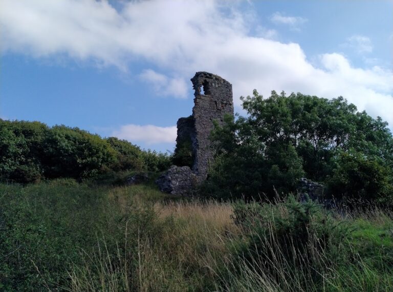
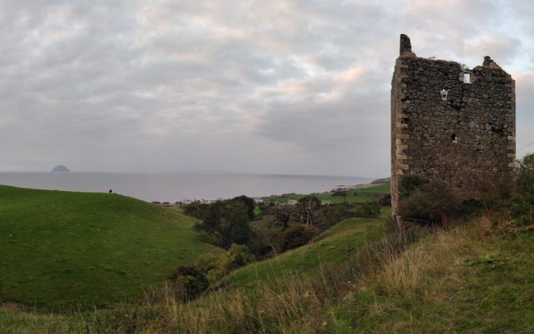
Dunskey Castle occupies a defensible promontory known as Castle Point on the south-west coast of Scotland near Portpatrick. Rocky cliffs rise above the North Channel, with the castle overlooking the sea passage towards northern Ireland. The principal building is a three-storey, L-plan tower house made of rubble masonry. It measures approximately 30 by 14.3 to 14.5 metres, with walls about 1.5 metres thick, and survives as a roofless shell.
A rock-cut ditch protects the only landward approach on the north-east side. About 15 metres wide and 2.5 metres deep, it is at least partly natural in places. The north-east wing was added later to the main structure. Foundations of a south range remain visible, while another foundation west of the tower house measures about 7 metres square and may represent an additional watchtower or building.
Adair enlargement and entrance
The Adair rebuilding campaign enlarged the complex on the landward side. The added section appears to have contained three cellars or vaults, with a new hall above them measuring about 36 by 17 feet. The hall contained a large fireplace. The principal entrance seems to have occupied the lower south-eastern corner, where an arched doorway led to a circular stair rising towards the hall. Only the upper part of the arch survives, and one of the new cellars or vaults appears not to have had a doorway.
Montgomery extension and coastal features
Montgomery’s seventeenth-century work included a gallery leading from the hall, with vaults beneath it. An eighteenth-century drawing still showed the southern foundations and sea wall, and appears to depict a large entrance door in the southern corner.
A watchtower remains near the castle on the cliff edge. It is approximately 7 metres square, and a map drawn around 1580 to 1590 depicts two watchtowers along the sea-facing cliffs. A cave is also reported beneath the castle, or beneath the house built over it, extending a considerable distance underground. Its full extent and relationship to the castle remain uncertain.
Nearby sites