Carleton Castle: A Fifteenth-Century Cathcart Tower Castle in Scotland


Site at a Glance
- Rating
- 4.4
- Popularity
- Very Low
- Country
- United Kingdom
- Primary era
- Medieval
- External website
- Open
- Eras represented
- Medieval
- Civilizations
- Kingdom of Scotland
- Site type
- Military
- Remains
- Castle
On this page13 sections
History
Carleton Castle is a fifteenth-century medieval tower castle in the United Kingdom, built by the Cathcarts of Killochan in the historic district of Carrick in south-west Scotland. The castle occupied a strategic position above Lendalfoot, overlooking Carleton Bay near the Games Loup cliffs, where it controlled a mountain pass and the old inland road to Portpatrick. It remained in use from the fifteenth century until the early eighteenth century.
The Cathcart possession
Carleton was held by the Cathcarts of Killochan, a Scottish aristocratic family whose estates and castles extended through Carrick and East Ayrshire. The family’s possession of Carleton reached back to the reign of King Robert I, commonly known as Robert the Bruce, who ruled Scotland from 1306 to 1329. In the 1860s, Sir Reginald Cathcart of Killochan held charters dated 1324 and another issued by King Robert II in 1386. Robert II reigned from 1371 to 1390 and was the first monarch of the Stewart dynasty.
Carleton formed part of a wider group of Carrick castles connected with the Cathcarts. The family also held Little Rigend and Camregan castles in East Ayrshire. Its position beside a route to Portpatrick gave the castle a military and estate-management role, while its fortified form provided a residence for the family or its representatives.
Names, traditions, and historical memory
The name Carleton may derive from “carl” or “churl,” a term associated with a serf’s dwelling. Another tradition connects it with Cairiltoun, a name recorded in the records of Whithorn Priory, a major medieval religious foundation in south-west Scotland. This interpretation means “the dwelling of the Cairils” and links the Cairils with an alleged migration from County Antrim to Carrick in 1095. These explanations belong to differing traditions about the place-name.
A ballad called May or Mary Culzean associates the castle with the story of Sir John Cathcart. In the tale, Cathcart enriched his estate by marrying heiresses and arranging their deaths at the nearby Games Loup cliffs. His ninth bride, Mary Kennedy of Culzean, supposedly threw him from the cliffs after he announced that he intended to kill her. The story adds that ghostly screams from Sir John or his eight murdered wives could later be heard from the castle.
A John Cathcart of Carleton is historically attested, but he lived at Killochan Castle. His wife was Helen Wallace, and their sons John and Robert were probably born at Killochan. Robert Cathcart is regarded as the author of the scholarly Historie of Kennedyis. The relationship between this historical John Cathcart and the later ballad tradition remains unknown.
Decline and later history
Carleton Castle was abandoned after its period of use and later altered in a way that may indicate conversion for domestic or storage purposes. A collapsed section of wall was partly rebuilt, and plaster was applied to the interior during a later phase. Maps provide a sequence of evidence for the castle’s changing condition. Willem Blaeu’s map of the 1660s shows it intact, John Adair recorded it in 1685, and Herman Moll’s 1745 map shows the old Portpatrick road passing close by. A 1775 map depicts Carlton apparently before it had become a ruin, while Taylor and Skinner’s road map from the same year is the first to identify the castle clearly as ruined.
The site is now a ruin and is privately held by Little Carleton Farm. Carleton Castle is a Category B Listed Building, a protected Scottish historic building regarded as of regional or more than purely local importance. The castle is not open to the public.
Remains
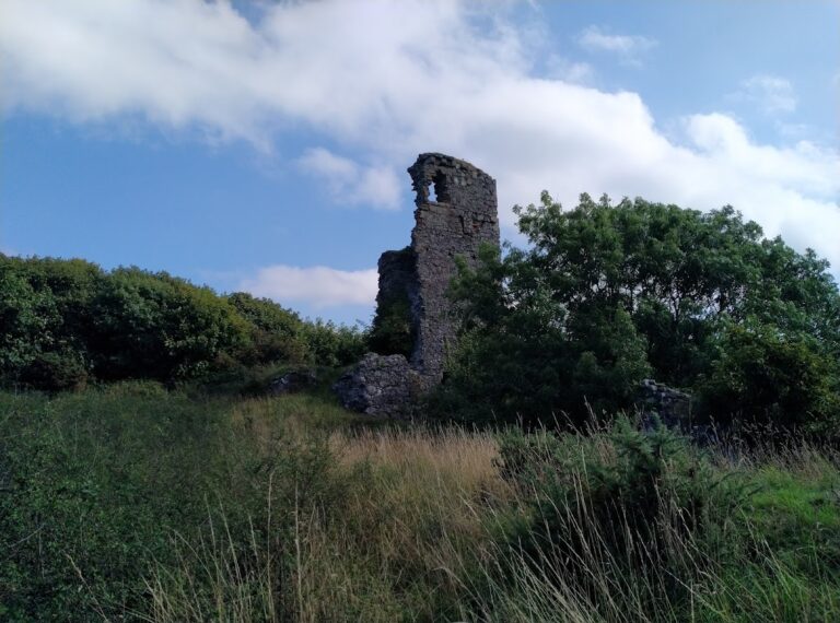
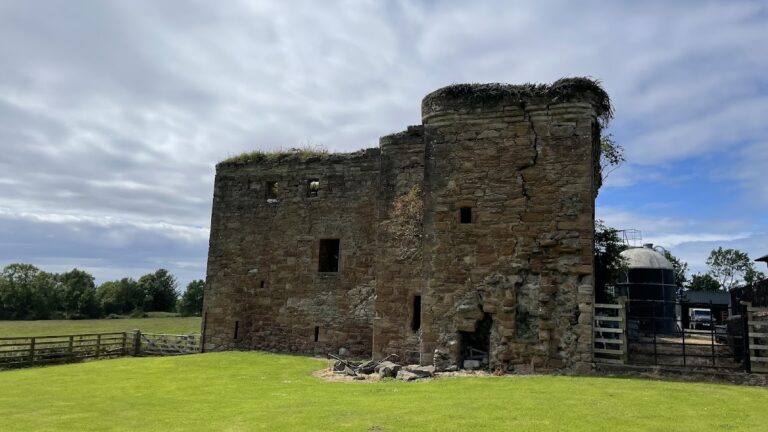
Carleton Castle stands in a prominent position above Lendalfoot, overlooking Carleton Bay and the nearby Games Loup cliffs. The surviving complex consists of a five-storey stone tower and a barmakin, a fortified courtyard or enclosure, set between two relatively deep glens formed by small unnamed streams. The castle’s position between these natural features provided protection on two sides, while the courtyard helped enclose the principal residence.
Stone castle
Tower house
The oblong tower was arranged around a single private apartment. A stair from a window in the great hall led to this room, while the main entrance originally stood at first-floor level and was reached by a wooden ladder or stair. The entrance wall is approximately 6 feet, or 1.8 metres, thick. It may have contained a stair leading to the cellar, the great hall, and a probable kitchen level. A wheel stair, meaning a narrow spiral staircase built around a central axis, connected the hall with the cellar.
Two vaults survive in the tower, one over the great hall and another above the ground floor. Nineteenth-century engravings show that a considerably larger section of the great hall’s vaulted ceiling survived at that time. Red sandstone appears to have been selected for decorative elements, including the upper vault and the arches over the windows. On the side facing the farm, a prominent garderobe, or medieval privy with a waste chute, projects from the tower.
Barmakin courtyard
The barmakin was a walled courtyard with towers at its angles. The side not protected by the two glens was shown on Blaeu’s map of the 1660s as being enclosed by a pale, or fence. This courtyard formed the outer defensive and domestic space around the tower. The missing parapet and the collapse of part of one wall now leave the enclosure fragmentary, while later rebuilding and internal plastering preserve evidence of possible reuse as a dwelling or store.
Rear structures
Behind the tower are ruins resembling pigsties. Ordnance Survey maps indicate that these structures were still roofed during the nineteenth century. Their surviving remains form part of the later agricultural setting associated with the castle and Little Carleton Farm.
Earlier earthworks and surrounding features
Little Carleton Fort or Motte
Opposite Little Carleton Farm stands Little Carleton Fort or Motte, an artificial or modified earthen mound that predates the stone castle by several centuries. The mound is approximately 5 metres, or 16 feet, high and 20 metres across. A circular ditch surrounds it, and its bank was once palisaded. Construction of the lane to the village damaged the earthwork.
The Cathcarts also held the motte. Because it stands close to the castle, it may have served as a moot hill, a traditional meeting place for a local court, where the laird’s barony court could assemble under the landholder’s authority. No evidence has linked the earthwork with a gallows hill.
Carleton Hill
Carleton Hill rises to approximately 520 feet, or 158 metres, from the coastal road. Earth banks near its summit have been identified as a probable ancient fort. This earlier defensive feature forms part of the wider archaeological landscape around the later castle.
Lousey or Lausey Knowe
South of the Lendal Water is an artificial mound called the Lousey or Lausey Knowe. Local tradition connects its name with the removal of lice from children’s hair. Another interpretation derives it from a Scots term for a fire or signal hill, linking the mound with the castle’s security and military activities. Together with the Games Loup cliffs and the Lendal Water, it belongs to the landscape associated with Carleton Castle.
Nearby sites