Dolmen de la Coma Enestapera: A Prehistoric Megalithic Monument
Site at a Glance
- Rating
- 5
- Popularity
- Very Low
- Country
- France
- Primary era
- Bronze Age
- External website
- Open
- Eras represented
- Stone Age, Bronze Age
- Civilizations
- Unclassified
- Site type
- Burial
- Remains
- Tomb
On this page8 sections
History
Prehistoric date and later use
The Dolmen de la Coma Enestapera is a prehistoric monument built from large stones around a chamber, on a rise above the Mediterranean near Cerbère, France. It is generally dated to either the fourth or third millennium BC, but its age remains uncertain. Carreras and Tarrús associate the proposed corridor type, with a passage leading into the chamber, with the fourth millennium BC. They place simple dolmens, where the chamber is entered directly, in the latter half of the third millennium BC. Jean Guilaine questioned whether dolmens in Pyrénées-Orientales could be dated as early as the fourth millennium BC, since the evidence does not establish that date.
The chamber was broken into in antiquity, and people later used the monument as a shelter over the centuries. The dolmen also gave its name to the locality of Coma Estapera. The Catalan name has been interpreted as “the valley where this stone is” or simply “the stone.” Other names for the monument include Dolmen of Coll de Cerverol, which reflects an incorrect location, and Dolmen of Coll del Pinyer.
Records and archaeological study
Ludovic Martinet first mentioned the dolmen in 1882 as the Dolmen of Coll de Cerberol. In 1884 he published a fuller description based on information from other people. The dolmen was listed as a historic monument in 1889 under Banyuls-sur-Mer; Cerbère became a separate commune that same year.
Despite its listing, the site received little attention from researchers for a time. A 1912 study of megalithic monuments in Girona province also covered sites in Pyrénées-Orientales. Pierre Ponsich later rediscovered the dolmen and included it, with a map, in a 1950 inventory of Roussillon dolmens. Jean Abélanet and Ponsich excavated the chamber in 1963, recovering few finds.
An archaeological group from Alt Empordà, GESEART, studied the monument in 1987. Abélanet discussed it in publications in 1998 and 2010, and included it in a 2011 book on megalithic monuments in Pyrénées-Orientales. He also wrote that he had forgotten the site’s location. Josep Tarrús’s thesis, defended in 1999 and published in 2002, placed the dolmen in an inventory of monuments across the Pyrenees between Roussillon and Alt Empordà. Tarrús returned to it in a detailed study in 2012.
Remains
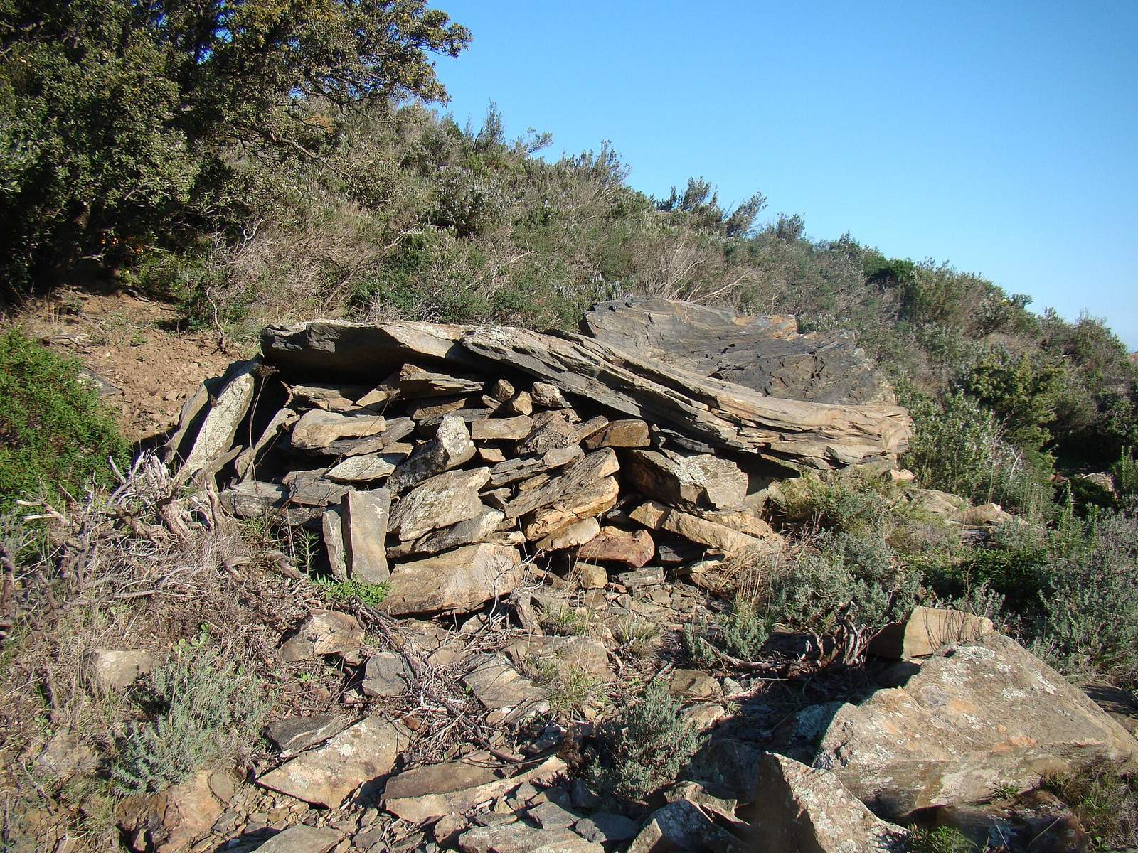
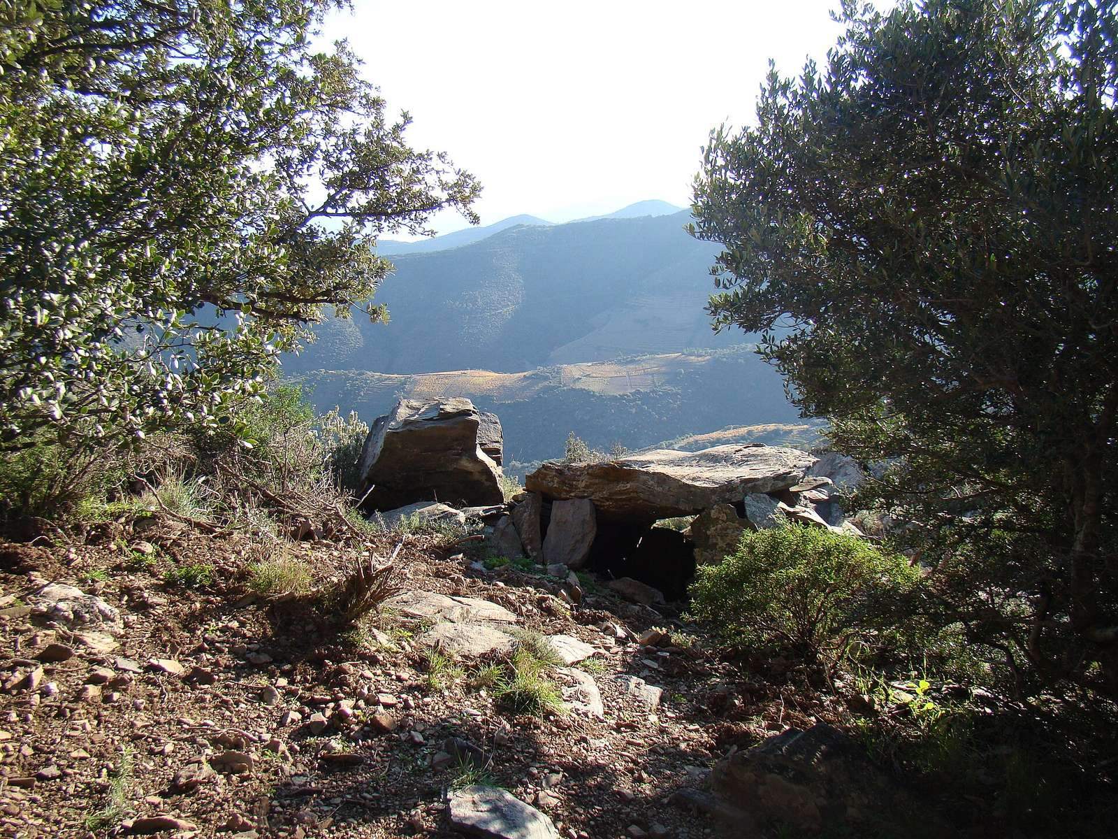
The small monument comprises a stone chamber beneath a broad capstone, with a low mound around it. It stands at about 323 metres above sea level on a Pyrenean rise overlooking the Mediterranean, in northern Cerbère near the boundary with Banyuls-sur-Mer. The site lies about 500 metres from Puig Joan, along a ridge running southeast, beyond Coll del Pinyer pass and below a rocky outcrop. Other nearby monuments include the dolmens of Gratallops, Coll de les Portes and Coll de la Farella, and the standing stones of Pedra Dreta de Sant Salvador and Perafita.
Chamber and associated features
Chamber and entrance
The monument is built entirely from slate schist, a stone that crumbles easily, and its thin supporting slabs are heavily eroded. The capstone slopes north and measures about 2.6 metres long by roughly 2 metres wide. The chamber has nearly parallel north and south sides, with the northern end wider. Its northern support is badly worn and split, creating the opening used as the entrance. Abélanet interpreted the support as a single slab buried below ground and broken above it. He considered two smaller slabs at the southern end to be closure stones and placed the original entrance there. Carreras and Tarrús instead regarded the northern opening as the original entrance, with its unusual direction explained by the rugged terrain.
The dolmen’s original plan is also disputed. Carreras and Tarrús classify it as a corridor dolmen, with a passage leading to the chamber, while Philippe Soulier identifies it as a simple dolmen, entered directly into the chamber. Abélanet considered the chamber’s polygonal appearance an accidental result of the break in its northern support.
Mound and shelter adaptation
Stones were packed into gaps between the main slabs when the monument was adapted as a shelter. Its flat mound is largely concealed by vegetation and may measure about 6 metres across.
Martinet’s 1884 description, based on information supplied by others, characterized the capstone as oval, about 3 metres long and 2 metres wide, and 60 centimetres thick. It described one side resting on the ground, with the other three supported by stacked stones.
Excavated finds
The chamber excavation produced a small group of finds: charcoal, fragments of glazed and hand-modelled pottery, an unidentified metal tool, iron shoe nails and a small flint chip.