Dairizuka Kofun Cluster: A Kofun-Period Burial-Mound Cemetery in Japan


Site at a Glance
- Rating
- 3.6
- Popularity
- Very Low
- Country
- Japan
- Primary era
- Medieval
- External website
- Open
- Eras represented
- Classical, Medieval
- Civilizations
- Yamato
- Site type
- Burial
- Remains
- Necropolis
On this page30 sections
History
Dairizuka Kofun Cluster is a group of burial mounds in Futtsu, Japan, built by regional chiefly lineages during the Kofun period, an era from approximately the third to seventh centuries when leaders expressed status and political relationships through monumental tombs. The cluster developed from the fifth through the seventh century on the alluvial plain of the lower Koito River and now includes 47 confirmed mounds, comprising 11 keyhole-shaped, 7 square, and 29 circular examples.
Formation of a Regional Chiefdom
The cemetery’s principal burials are associated with a lineage of regional chiefs who later became the kuni no miyatsuko of Sue, a hereditary local ruling office recognized within the early Japanese political order. Dairizuka Kofun, built in the middle of the fifth century, represents the earliest known major mound in the lower Koito River basin. Its construction has been interpreted as evidence for the emergence of a chief who brought the alluvial plains of western Kazusa, an ancient province covering much of the central and southern Boso Peninsula, under a single authority.
Before Dairizuka Kofun was built, no regionally dominant mound had been identified in the lower Koito basin. Mounds dating from the fourth century in the middle and upper basin were generally keyhole-shaped or circular and measured about 40 to 60 metres. Settlements from the late Yayoi period through the Kofun period were present in the lower basin, while the possibility of earlier undiscovered mounds has also been proposed.
Dairizuka was followed by Benten-yama Kofun outside the cluster and then by Uwanotsuka Kofun in the late fifth century. Mound construction within the cluster then stopped for roughly half a century before resuming with Kujozuka Kofun in the middle of the sixth century. The smaller size of Benten-yama compared with Dairizuka, together with this interruption, has been interpreted as evidence that chiefly authority had weakened. Another interpretation proposes that authority had shifted outside the cluster.
Renewed Construction and Political Consolidation
The decline in mound construction from the late fifth to the early sixth century affected Kazusa, other parts of the Kanto region, and the Kinai, the area around the ancient political centres of central Japan. One interpretation connects this wider change with social disorder and the disruption of burial conventions caused by the weakening of the Yamato polity, the early Japanese political centre that later developed into the imperial state.
Construction resumed with Kujozuka Kofun in the middle of the sixth century. During the later sixth century, the leading mounds Inariyama and Sanjozuka were built alongside medium-ranking keyhole mounds including Kozuka, Nishihara, Himizuka, and Warabizuka. Smaller circular mounds, such as Shirahimezuka, Shinwari, and Hatchozuka, were constructed at the same time. The cemetery reached its peak between the middle and end of the sixth century.
The different mound sizes indicate the activity of several chiefly lineages rather than a single uninterrupted succession. The large, middle-ranking, and smaller mounds probably represented about three levels of chiefs who maintained close relationships. Their shared cemetery may have reinforced unity within the ruling groups while displaying that unity to communities beyond them.
The prominence of large mounds in the later sixth century has been connected with control of the important route between the Miura Peninsula and the Boso Peninsula. The chiefs of the cluster are therefore thought to have strengthened their economic and political authority, developed direct relationships with the Yamato polity, and eventually become local provincial rulers. The concentration of powerful chiefs along separate river basins may also reflect the hilly geography of the peninsula, which encouraged the formation of distinct local authorities.
Seventh-Century Transformation
Keyhole-mound construction ended in the seventh century. Square mounds continued to be built until approximately the middle of that century, probably through the simultaneous activity of several chiefly lineages. Mound construction ended in the latter seventh century, after which regional authority was increasingly expressed through temples rather than burial mounds.
Near the end of the seventh century, Tsukumo-bo Haiji, a temple site, was established about 6 kilometres east of the cemetery. This change has been interpreted in two ways. It may indicate that the chiefs’ bases lay apart from their burial ground, or it may show that the centre of the Koito River basin had shifted away from the cluster, which stood somewhat apart from the peninsula’s principal transportation routes.
Name, Preservation, and Investigation
The cluster was formerly often called the Iino Kofun Cluster because most of its mounds lay within the former area of Iino Village. Dairizuka Kofun Cluster became the standard name because the group also extended into the former Aohori area and because later administrative changes caused “Futtsu” to refer to a wider municipality. The name remains debated, since Dairizuka is the only leading mound built in the middle of the fifth century, while the cemetery reached its greatest concentration of construction from the middle of the sixth to the seventh century.
The cemetery is relatively well preserved compared with the neighbouring Gion-Nagasuka Kofun Cluster, where most mounds have disappeared. Parts of 25 of the 47 confirmed mounds survive, while 22 have disappeared. The original number was probably higher because some mounds vanished without being recorded.
Investigations have taken place since at least 1892. Studies of Shirahimezuka in 1892, Nishihara in 1927, Himizuka in 1938, Hatchozuka in 1964, Warabizuka in 1966, Nonoma and Koyama in 1968, Shinwari in 1981, Moriyamazuka in 1983, Kamezuka in 1989, and Aokikamezuka in 1990 and 1996 revealed burial facilities, human remains, grave goods, mound forms, and nearby settlement remains. Dairizuka Kofun became a national historic site in 2002. Kujozuka, Inariyama, and Sanjozuka received municipal historic-site designation in 1973.
Remains
The cluster occupies roughly 2 square kilometres on the alluvial plain formed by the lower Koito River. The coastline lies to the northwest, the Koito floodplain to the east, and an abandoned river course to the south. Many mounds were built on slightly raised former dune ridges that run from northeast to southwest. The rounded rear sections of many keyhole mounds face northeast, while their projecting front sections point southwest.
Leading Keyhole Mounds
Dairizuka Kofun
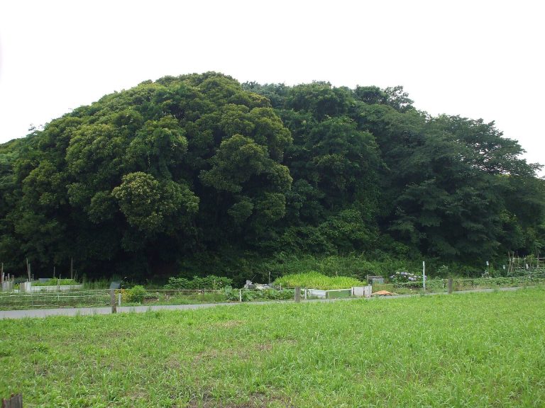
Dairizuka Kofun is a keyhole-shaped mound, combining a rounded rear section with a projecting rectangular front, that measures 144 metres in length. It was the first keyhole mound in the Koito River basin and the largest mound in southern Kanto, including Saitama, Chiba, Kanagawa, and Tokyo. The mound rises more than 10 metres and contains a vertical stone chamber, a burial chamber entered from above.
Uwanotsuka Kofun
At the northern end of the cluster, near Aohori Station, Uwanotsuka Kofun forms a scallop-shell-shaped keyhole mound with a short front section. It measures 44.5 metres in total length and is attributed to the late fifth century.
Kujozuka, Inariyama, and Sanjozuka
Kujozuka, Inariyama, and Sanjozuka are leading keyhole mounds more than 100 metres long. Their comparatively low mounds rise about 5 to 8 metres and are enclosed by double moats. Inariyama measures 106 metres, or 202 metres when the moat zone is included. Its main burial facility has not been investigated, but haniwa, clay figures and cylinders placed on or around burial mounds, indicate a date in the later sixth century.
Middle-Ranking Keyhole Mounds
Kozuka Kofun
Kozuka Kofun measures 89 metres and is the largest mound immediately below the leading mounds in scale. The JR Uchibo railway line cut through its western side, but most of the remaining mound retains its original form. A line of haniwa was found on the mound. Its shape and haniwa place it in the later sixth century, close in date to Inariyama Kofun.
Nishihara Kofun
Nishihara is a keyhole mound crossed through its centre by the JR Uchibo railway line, leaving part of its rounded rear section. Its horizontal stone chamber, which has an entrance passage leading from the side, remains comparatively well preserved. Excavation in 1927 recovered the remains of eight people, straight swords, gilt-bronze horse fittings, gilt-bronze and silver earrings, glass beads, and Sue ware, a high-fired pottery associated with the Kofun period. The mound dates to the middle of the sixth century, around the time of Kujozuka.
Himizuka Kofun
Himizuka was a 61-metre-long keyhole mound, of which only part survives. Excavation in 1938 recovered five human skeletons, straight swords, gilt-bronze earrings, horse fittings, and Sue ware. The mound was built in the later sixth century, around the time of Inariyama and Kozuka.
Warabizuka Kofun
Warabizuka measures 48 metres. Its western side and part of its front section have been extensively cut away. A 1966 excavation found a horizontal stone chamber with a shell-covered floor. At least 12 human skeletons lay with gilt-bronze and silver earrings, beads, horse fittings, and Sue ware. The mound dates to the end of the sixth century, around the time of Sanjozuka.
Buheizuka Kofun
Buheizuka is estimated to have measured between 60 and 70 metres, although only part of the mound survives and it has been little investigated. It lies near Kujozuka and has almost the same orientation, suggesting a close relationship between the two mounds.
Aokikamezuka Kofun
Aokikamezuka measures 106 metres, the same length as Inariyama and the third-largest mound in the cluster. No haniwa were found on its mound. A trench investigation in 1990 found neither a stone chamber nor traces of one, while a 1996 excavation beside the mound uncovered a settlement dating from the later Kofun period to the Nara period. These findings led to the proposal that the keyhole mound was abandoned before construction was complete.
Square Mounds of the Seventh Century
Warimizuka Kofun
Warimizuka is a square mound measuring 40 metres on each side. Its double moat zone expands the total dimensions to 107.5 metres per side. The horizontal stone chamber, including its forecourt, measures 18.75 metres, the longest recorded horizontal stone chamber in the Boso Peninsula. The mound was built during the first half of the seventh century.
Kamezuka Kofun
Kamezuka is a large square mound measuring 38 metres per side, or 99 metres including its double moats. It has been heavily cut away. Part of the damage resulted from a prison that formerly stood in the mound’s northeastern area beside Iino Jinya, the regional administrative and residential headquarters of the Iino domain. Excavation in 1989 recovered gilt-bronze earrings, a bronze bowl, and glass beads.
Moriyamazuka Kofun
Moriyamazuka is a 27-metre square mound and the third-largest square mound in the cluster. It has suffered heavy damage. Excavation in 1983 recovered Sue ware, Haji ware, a lower-fired pottery tradition of ancient Japan, and iron nails. The nails are thought to have belonged to a wooden coffin placed inside a stone chamber.
Nonoma and Inarizuka
Nonoma disappeared during residential development. It measured 19.5 metres and had double moats that brought its overall dimensions to 59.5 metres. Emergency excavation in 1968 recovered a silver-inlaid sword, gilt-bronze earrings, and a green-glazed long-necked jar produced in Silla, a Korean kingdom that maintained relations with the Japanese archipelago during the Kofun period.
Inarizuka was a square mound within Iino Jinya and has also disappeared. A boundary-confirmation survey in 1990 established that it measured 21.4 metres on each side.
Circular and Scallop-Shell Mounds
Shirahimezuka Kofun
Shirahimezuka is a surviving circular mound 30 metres in diameter. Excavation in 1892 recovered four ornamented swords, a gilt-bronze bowl, gilt-bronze earrings, belt fittings, and other rich grave goods. These finds indicate that it was among the earlier circular mounds in the cluster.
Maruzuka Kofun
Maruzuka was a circular mound 30 metres in diameter. It was excavated in 1974 and later disappeared during land readjustment. Approximately ten human skeletons were found with straight swords, horse fittings, beads, gilt-bronze earrings, and Sue ware.
Shinwari Kofun
Shinwari disappeared during residential development in 1981. Excavation before construction showed that it was a 35-metre circular mound with a projecting platform. It was the largest circular mound in the cluster and could also be regarded as a scallop-shell-shaped keyhole mound. More than 20 human skeletons were recovered with straight swords, beads, gilt-bronze earrings, and Sue ware.
Koyama Kofun
Koyama was a 29-metre circular mound that disappeared during the construction of company housing in 1968. Excavation recovered the remains of at least eight people, a large sword, gilt-bronze earrings, iron horse fittings, an agate bead shaped like a magatama, an amber jujube-shaped bead, glass beads, and other rich grave goods. It is considered relatively late among the circular mounds.
Nishitani and Hatchozuka
Nishitani is a 28-metre-long mound that still survives, although a road plan anticipated its future disappearance. Excavation in 1951 recovered the remains of at least 13 people, a knife, glass beads, and Sue ware.
Hatchozuka is a surviving circular mound 24 metres in diameter. Excavation in 1964 recovered a straight sword, horse fittings, gilt-bronze earrings, tubular jasper beads, and amber jujube-shaped beads. The finds indicate that Hatchozuka belongs among the later circular mounds.
Buheizuka-Minami Kofun
Buheizuka-Minami lies about 200 metres southwest of Buheizuka. A horizontal stone chamber is thought to lie beneath the surviving part of the mound. Fragments of cylindrical haniwa were found on and around it. Since haniwa were otherwise found at Dairizuka, Kujozuka, Inariyama, and Kozuka, Buheizuka-Minami may have been a keyhole-shaped tomb.
Burial Chambers and Grave Goods
The middle-sixth-century and later mounds generally used horizontal stone chambers made from sandstone collected on the coast of Futtsu. This contrasts with Dairizuka Kofun’s vertical chamber. The same sandstone was used in the horizontal chamber of Kanazurizuka Kofun in the neighbouring Gion-Nagasuka Cluster and at Shogunyama Kofun in the Sakitama Kofun Cluster, indicating connections among the chiefly groups that created these cemeteries.
The excavated chambers contain large concentrations of human remains. Eight people were found at Nishihara, at least 12 at Warabizuka, and more than 20 at Shinwari. These groups of burials are interpreted as the result of repeated additional interments over long periods. All sixth-century mounds in the cluster are understood to have used horizontal stone chambers, while nearby small circular mounds generally used wooden coffins buried directly in the mound.
Haniwa, including cylindrical examples, occur among the mounds. Other grave goods include swords, horse fittings, earrings, beads, bowls, belt fittings, pottery, and imported objects. Their distribution and contents reveal differences in rank and connections that extended beyond the local region, while the form and construction of the mounds preserve the changing organization of chiefly authority from the fifth to the seventh century.