Crèvecœur Castle: A Medieval Fortress Above the Meuse in Belgium


Site at a Glance
- Rating
- 4.4
- Popularity
- Low
- Country
- Belgium
- Primary era
- Medieval
- External website
- Open
- Eras represented
- Medieval
- Civilizations
- Duchy of Burgundy, Holy Roman Empire
- Site type
- Military
- Remains
- Castle
On this page11 sections
History
Crèvecœur Castle is a medieval fortress in Belgium, above Bouvignes-sur-Meuse near Dinant, whose surviving upper castle is centred on a square tower built around 1320–1321. Its earliest history is uncertain: the site is described as having first contained a Roman castrum, a fortified settlement or military stronghold, and as having been strengthened by the Normans in the ninth century. The medieval fortress is more securely associated with the counts of Namur from the late eleventh or early twelfth century.
The Namur Fortress
At the end of the eleventh century, Godfrey I, Count of Namur, had a fortress built at Bouvignes. His son Henry the Blind, a twelfth-century count of Namur and Luxembourg, strengthened it with massive enclosing walls. By 1176, the defensive system had been completed further with a wall flanked by several towers. The castle belonged to a frontier landscape shaped by the rivalry between the County of Namur and the Prince-Bishopric of Liège, two medieval political territories whose competing interests affected Bouvignes and nearby Dinant.
Fire traces at the site are associated with the siege of Bouvignes by Baldwin V, Count of Hainaut, in 1188. Knights from Champagne helped the Namur forces defend the fortress. In 1214, Waleran III, Duke of Limburg, besieged it on behalf of Ermesinde, Countess of Luxembourg, but the castle resisted the attack.
Conflict with Liège
Liège forces began to threaten the castle during the fourteenth century. A siege in 1321 failed, and a new square tower was probably erected around 1320–1321 on a separate rock. This position countered the Montorgueil tower built by the people of Dinant on the opposite bank of the Meuse. The two fortifications represented the continuing rivalry between Bouvignes, in the County of Namur, and Dinant, in the Prince-Bishopric of Liège.
Master builder Godefroid de Bofiaule extended Crèvecœur in 1388. Another building phase followed during and after a later siege, when Bouvignes was under the control of Burgundy. The upper fortress therefore continued to develop as military pressure and political control changed around the Meuse valley.
The Siege of 1429
On the night of 5–6 February 1429, Jean le Blondel, also known as Blondeau and captain of Crèvecœur, attempted to capture Montorgueil. At the request of the people of Dinant, Prince-Bishop John of Heinsberg began the Liège–Namur War of 1429–1431, a conflict between the territories associated with Liège and Namur. Liège forces attacked Crèvecœur with a medieval “cat,” a mobile structure used to approach or attack fortified walls. They seriously damaged the castle but failed to enter it. The siege ended after Philip the Good became Duke of Burgundy and a truce followed.
The conflict is also linked with the tradition of the Three Ladies of Crèvecœur. According to the local story, three knights defending the castle were killed, after which their wives took up arms. When defeat became inevitable, the women withdrew to the tower and jumped from its parapet in long white robes. The tale is associated with the name Crèvecœur, meaning “broken heart.” Since at least 1778, the same legend has also been connected with the French siege of 1554, and it remains part of Bouvignes folklore.
French Attacks and Decline
In 1554, during the conflict between Henry II of France and Charles V, French forces sacked Dinant and Bouvignes. Crèvecœur capitulated and was heavily damaged by artillery after resisting the French army. The attack ended its military function, and the site was thereafter manned only as a watchtower.
The castle was partly rebuilt between 1567 and 1580. French forces captured it for the last time in 1655, and it was dismantled in 1672 under the supervision of François d’Otreppe. Its later history included a final military episode on 13 May 1940, during the Battle of France. German troops from II./Schützen-Regiment 7, part of Erwin Rommel’s 7th Panzer Division, seized the castle from the French II/66th Infantry Regiment after crossing the Meuse at Bouvignes.
The ruins were restored in 1950–1951. Crèvecœur Castle is owned by the Walloon Region, and its surviving fabric preserves the remains of a fortress repeatedly altered by medieval rivalry, artillery warfare, dismantling, and later conservation.
Remains
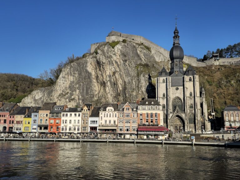
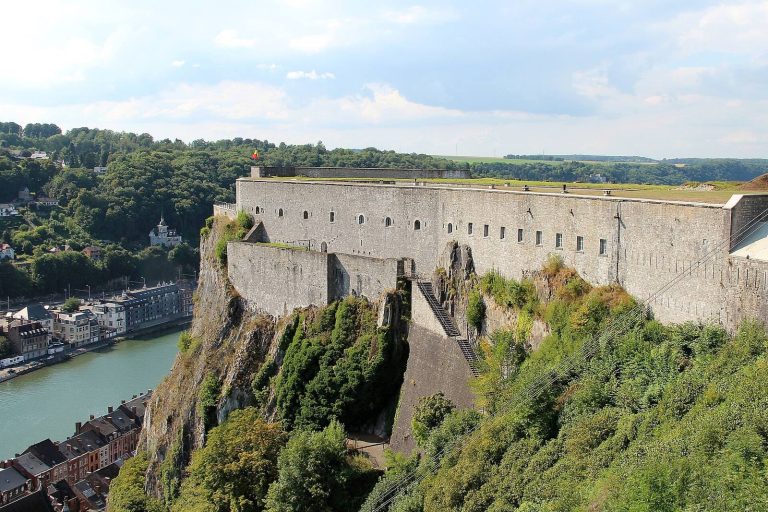
The ruins stand on the left bank of the Meuse, on a cliff approximately 80 metres above the river. The former fortress is arranged in an upper castle, known as Crèvecœur itself, and an older count’s castle below it. The lower complex is approximately three times as long as the upper castle and occupies three levels, creating a stepped arrangement between the rocky height and Saint Lambert’s Church.
The Upper Castle
The Square Keep
The upper castle is centred on a square keep, or principal fortified tower, erected around 1320–1321 on a separate rock. It is sometimes identified as the Tower of Crèvecœur. Two stairways, each with twelve steps, lead along the keep toward a projecting semicircular bastille, a fortified structure extending outward from the main defence. Around 1430, the Crèvecœur complex reached an overall length of approximately 40 metres.
The Semicircular Towers
A semicircular lower tower on the Meuse side was added during the siege of 1430. It contained seven gun loops, openings through which firearms could be used. Together with the projecting bastille and the square keep, this surviving upper group represents the castle’s later medieval defensive arrangements.
The Count’s Castle
The Three Terraces
Below the upper castle lie the ruins of the older count’s castle. Its highest and oldest level is situated at the height of the Romanesque keep, a tower belonging to the medieval tradition that developed in western Europe before Gothic architecture became widespread. The keep’s ground plan measures approximately 15 by 11.5 metres.
A second terrace, about five metres lower, contained the farmstead. It was extended toward Saint Lambert’s Church in the thirteenth century and includes a remarkably well-preserved cellar. The Saint Catherine’s Chapel, the mint, and the large hall that served as the town hall were also located on this terrace. The third and lowest terrace extended up to Saint Lambert’s Church, completing the descending layout of the older castle.
Today the site is a ruin field owned by the Walloon Region. The surviving terraces, tower remains, cellar, and defensive structures retain the physical divisions of a fortress that developed across several centuries and was repeatedly modified for changing military purposes.