Coupar Angus Abbey: A Cistercian Monastery in Scotland
Site at a Glance
- Popularity
- Medium
- Country
- United Kingdom
- Primary era
- Medieval
- Eras represented
- Medieval
- Civilizations
- Kingdom of Scotland
- Site type
- Religious
- Remains
- Fortified Monastery
On this page12 sections
History
Foundation and early growth
Coupar Angus Abbey was a Cistercian monastery in Coupar Angus, Scotland, in the United Kingdom. Founded in 1161–62 and dedicated to the Virgin Mary, it was the fifth Cistercian establishment in Scotland. The Cistercians were a monastic order that followed the Rule of St Benedict. Coupar Angus was founded through Melrose Abbey, its mother house, within a lineage connected to Clairvaux in France. It grew into one of Scotland’s leading and most prosperous Cistercian houses.
King Malcolm IV granted land for the foundation sometime between 1154 and 1162, following the advice of his uncle Waltheof, abbot of Melrose. Monks may have arrived as early as 1159, while a complete community was in place by 12 July 1164. A royal grant refers to a manor at Coupar, suggesting that an agricultural community may have occupied the area earlier, though this remains unconfirmed. The abbey church was being used for worship by 1186 and was consecrated on 15 May 1233 by Gilbert, bishop of Dunkeld. The buildings were probably largely complete by then.
Land, farming and trade
The abbey acquired substantial estates from an early date. Their gradual consolidation brought its landholdings to about 8,000 acres (32 square kilometres) in the fourteenth century. Properties extended across roughly 200 miles, from sea level to about 900 metres in the Cairngorms. Early royal grants included timber-cutting rights in nearby forests. Charters issued under William the Lion described lands more precisely than Malcolm IV’s early grants. Some places named in the first grants may have been intended holdings rather than possessions, while Coupargrange and Keithick were probably organized by the 1220s. Many tenants may have continued working land they had cultivated before it came under the abbey, rather than being replaced by lay brothers, members of the religious community who undertook manual work.
Sheep and wool became central to the abbey’s economy. The earliest surviving evidence of its wool trade dates to 11 April 1225, although the business probably began earlier. The flock exceeded 7,000 animals at its height. Estimates suggest it may have numbered 7,500–12,000 around 1300, nearly 17,000 in 1390 and close to 20,000 by 1420. Wool was sold raw and as woven cloth, including cloth made at Kincreich. An early-fourteenth-century estimate by the Italian merchant Francesco Balducci Pegolotti put annual production at at least 30 sacks, probably an underestimate. Wool may initially have been shipped through Berwick in coordination with Melrose; later arrangements appear to have sent exports through Peth under Coupar Angus’s direct management.
The abbey also drew income from fisheries, forests and mills. Rights at Logie Pert and Stinking Haven gave the monks access to freshwater and sea fish, and they later developed fishponds managed by lay brothers. In the later Middle Ages, many fisheries were legally outside the abbey’s direct control, but the community supplied a boat and monitored nets. Disputes with local lords over fishing grounds led to lawsuits in the fifteenth and sixteenth centuries. Woodlands, mostly west or south of the abbey, supplied timber and charcoal, pasture and some hunting. The monks managed timber for frequent repairs, including renewal of the roof framing about every seven years, and appointed a forester early in the abbey’s history. Hunting rules particularly targeted foxes and wolves, regarded as pests.
Mills provided another important source of income, with surplus products sold in nearby markets. From the mid-thirteenth century, water power also supported wool processing, brewing and metalworking. A fulling mill, which cleaned and thickened woven woollen cloth, operated at Kincreich, probably alongside a grange, a monastic farm and production centre making cloth. Around 1254 the monks established a forge at Linthrathen; it reappears in records in the fifteenth century. Granges could also support crafts such as tanning. In 1290 Hugh de Eure, lord of Kettins, granted the community Bradewell spring and a channel carrying water into the monastic grounds, possibly to expand tanning. The nearby Keithick grange served as a guesthouse and reserve of supplies. Its fields were intensively cultivated with ashes from the bakery, brewery and oven, and its rabbit warren supplied meat and fur for export.
Other assets extended the abbey’s commercial reach. In the 1230s it acquired a salt pan at Altens, south of Aberdeen, with access to peat for fuel. From the thirteenth century it also bought houses in Perth, Dundee and Berwick, with acquisitions reaching a high point in the fourteenth century. Berwick properties appear to have provided rental income, while those in Perth supported trade. Rents were often paid in goods such as wax, cumin and pepper. The community exchanged land, negotiated water rights for its mills and other work, and joined efforts to drain some marshland, although extensive drainage in the region came centuries later. In 1478–79 it challenged a new mill that threatened its market and water supply, and the abbot sought to require farmers to use mills assigned to them. The abbey’s control of Kincreich mill followed its donation by almost a century, after the donor and heirs obstructed the transfer.
Conflict, hardship and recovery
An English attack in 1305, attributed to Edward I, burned a grange and caused further damage. The abbot petitioned Edward II for compensation. Conditions worsened from the 1330s amid wars with England, plague and changes in land use. A prolonged cooler period known as the Little Ice Age, beginning in the late thirteenth century, may also have reduced pasture and made sheep farming more difficult. Disputes over livestock straying onto neighbouring land became common. In 1351 a papal bull described the abbey as exceedingly impoverished, but its fortunes later recovered.
By the Reformation, Coupar Angus was Scotland’s wealthiest Cistercian house, with an income of £5,590 and at least 24 monks. It had 28 monks in 1521. Donald Campbell, its last regular abbot, governed from 1526 to 1562. In 1531 the Cistercian general chapter, the order’s assembly of abbots responsible for governance and discipline, assigned him to correct abuses in other Scottish houses. Religious life at Coupar Angus appears to have remained at a high standard. In 1559 Campbell joined the Scottish Reformation, the sixteenth-century movement that broke Scotland’s ties with the Roman Catholic Church and established Protestant churches. He destroyed some Catholic symbols at the monastery, left religious orders and entrusted the abbey to his friend Katherine Campbell, Countess of Crawford.
Dissolution and decline
The abbey entered commendam in 1562, an arrangement that entrusted a monastery’s administration and revenues to a holder rather than a resident regular abbot. Leonard Lesley and then Andrew Lamb held the abbacy. The abbey was formally dissolved in 1606, and its lands passed to James Elphinstone as a secular lordship; a royal charter confirmed the change in 1607. Elphinstone appears to have lived in the abbot’s lodging and was obscurely implicated in the murder of Robert Lindsay, the priest serving the church after it became a parish church.
After Elphinstone’s death, the estate declined and went without maintenance. The abbey was considered ruined by 1622 and more severely so by 1680. Much of it may have been burned by Protestant reformers, and the buildings were probably dismantled for stone after Lord Coupar’s death in 1669. A replacement church was begun on 7 May 1686, substantially altered in 1780 and replaced in 1859. Abbey stone was reused in these churches and in buildings in the growing town. The monastery’s development had helped establish an urban centre beside it, the beginnings of the present town of Coupar Angus. Its gatehouse and precinct are each protected as scheduled monuments, sites formally protected in Scotland for archaeological or historic importance.
Records and archaeological interpretation
A substantial collection of the abbey’s charters and titles was compiled between 1443 and 1538. Much of the surviving charter collection, long thought lost, was found in the early twentieth century in the library of the Earl of Moray at Darnaway Castle. Nineteenth-century antiquarian clubs had sometimes changed records they considered erroneous without keeping a record of their corrections, complicating the interpretation of the abbey’s history.
Remains
Setting and surviving fabric
The abbey stood in the Strathmore valley, where the River Isla flows, at the south-eastern edge of Coupar Angus and near the junction of the Isla and Ericht rivers. Its remains lie within the village cemetery. The medieval buildings were made of local red sandstone, but the original layout remains uncertain. A drawing from 1820, once thought to show the plan, has since been found inaccurate.
Gatehouse and precinct
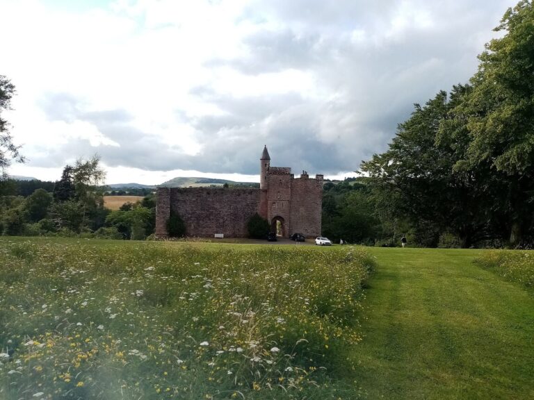
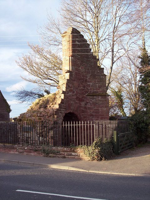
The principal visible ruin is a small fragment of the gatehouse. Older maps and pictures show a fortified tower at each corner of the monastic precinct; the surviving fragment may belong to its eastern tower. The abbey’s stables, brewery, bakehouse and forge are also recorded among the complex’s buildings.
Church and reused stone
The present parish church occupies the site of the abbey church. It preserves fragments of medieval stonework, including several tombs. Other pieces of abbey masonry have been built into walls around the modern town.
Pavement and burials
In December 1887, gravedigger William Spiers uncovered paving about four feet below ground while digging a grave. Archaeologists at the time considered it a possible remnant of the abbey’s original pavement, although it lay beyond the monastic boundary then estimated and within the medieval cemetery. The paving consists of small, regular red slabs set in mortar, laid in staggered rows and smooth on their upper surfaces. At least two single-piece tomb slabs were embedded in it. The skeletons beneath were fully preserved, though one slab broke during the discovery.
Ground evidence and traditions
Because the remains lie within a cemetery, excavation is restricted. Non-invasive metal-detector surveys have identified areas of potential archaeological interest to the north-east, east and south-east of the present church. A mound at the eastern edge of the site, also the edge of the medieval town, may be a landscaping bank or a collapsed wall later covered by vegetation. If it is a wall, it could date to the abbey or be older.
The idea that a Roman camp once occupied the site remains uncertain. Objects recovered in excavations have been attributed either to the abbey’s earliest period or to such a camp. A local tradition also tells of a tunnel beneath the precinct. Women were said to have found it in the nineteenth century, and one was said to have entered and disappeared. In 1982 a local mason may have found an entrance and followed the passage until a collapse blocked it. The unsubstantiated story claims that it continued for about two and a half miles to an underground chamber-and-passage structure at Pitcur.