Citadel of Namur: A Fortress at the Confluence of the Meuse and Sambre



Site at a Glance
- Rating
- 4.5
- Popularity
- High
- Country
- Belgium
- Primary era
- Early Modern
- External website
- Open
- Eras represented
- Classical, Medieval, Early Modern, Modern
- Civilizations
- Belgian, Duchy of Burgundy, Dutch, French, Habsburg, Holy Roman Empire, Roman
- Site type
- Military
- Remains
- Citadel
On this page13 sections
History
The Citadel of Namur is a historic fortress in Namur, Belgium, built and expanded by successive medieval, Burgundian, Habsburg, French, Dutch, and Belgian authorities on a rocky spur above the confluence of the Meuse and Sambre. Human camp settlements occupied the area from about 6000 BC, while a structured settlement and port stood on the left bank of the Sambre by the first century. The site later became the castle of the counts of Namur and, through repeated rebuilding from the fifteenth to the nineteenth centuries, one of Europe’s largest fortification complexes.
Early settlement and the county of Namur
Trade around the confluence expanded between the fifth and ninth centuries, and coins point to commercial connections with the Roman Empire. A fortified settlement occupied the rocky spur by at least the Gallo-Roman period. By no later than 890, a wooden fortress enclosed by a double palisade had been built there. The first documentary reference to a count of Namur dates from 925, and the counts’ principal residence on the site is securely known from 974. The wooden defenses were later replaced by stone fortifications.
From the second half of the tenth century until the fifteenth century, the castle served as the principal seat of the county of Namur. The complex gradually grew to include the collegiate church of Saint Peter of the Castle and residences for its canons. Twenty-three counts succeeded one another before Jean III, the impoverished last count without a legitimate heir, sold the county in 1429 to Philip the Good, Duke of Burgundy.
Burgundian and Habsburg expansion
Philip the Good incorporated Namur into the Burgundian state and enlarged and modernized the fortress, increasing its military importance. In 1477, the marriage of Mary of Burgundy, Philip’s granddaughter, to Maximilian of Habsburg brought the region into the Habsburg lands. The Habsburgs were the ruling dynasty that acquired territories through the Burgundian inheritance and this marriage.
Artillery transformed the castle’s defenses during the fifteenth and sixteenth centuries. Under Charles V, a Habsburg ruler, work began in 1542 on a bastioned enclosure later called Médiane. Donato de Boni initiated the project, which Sébastien van Noyen and Giovanni Maria Olgiati completed in 1559. The new works stood in front of the medieval defenses and included bastions, gates, a bridge, curtain walls, and later reconstructions. A bastion is a projecting section of wall that allows defenders to fire along adjoining walls, while a curtain wall is the main wall connecting fortified projections.
Sieges and seventeenth-century fortification
Namur’s position brought repeated warfare. The fortress endured more than twenty sieges between the fifteenth and nineteenth centuries. During the Burgundian civil war, the townspeople of Namur attacked it in 1488, using firearms actively. Troops commanded by Don Juan of Austria captured it by surprise in 1577. The fortress then changed hands during the wider conflicts associated with French expansion and the War of the League of Augsburg, a European war from 1688 to 1697 in which France fought a coalition that included the Dutch Republic and the Habsburgs.
Louis XIV’s army captured Namur in 1692. The Grand Alliance recaptured it in 1695, and the destruction caused by the two sieges led to major reconstruction. Vauban, the leading French military engineer of Louis XIV’s reign, rebuilt parts of the fortress in 1692 and added triangular bastions. Between 1695 and 1698, the Dutch military engineer Menno van Coehoorn installed an underground bakery beside the medieval curtain wall. Around 1690, he had also built Fort William, or Fort Orange, at the instigation of William III of Orange to strengthen the area around the Foliette ravine, regarded as a weak point.
A major upper defensive sector was constructed between 1631 and 1675 during the Thirty Years’ War and Louis XIV’s campaigns. Known as Terra Nova, it consisted of two bastioned lines designed by Salomon Van Es and Jean Boulengier. Together with Médiane and the medieval castle, it gave the fortress a three-level defensive organization.
Austrian rule and the 1746 siege
After the Treaty of Utrecht, the former Spanish Netherlands became Austrian, and Namur entered the Barrier system. This defensive arrangement was administered and garrisoned by the Dutch to help protect against French expansion. During the War of the Austrian Succession, an eighteenth-century conflict over the Habsburg succession, Louis XV’s forces besieged Namur in 1746. The Dutch garrison capitulated after three weeks.
During the siege, a powder magazine exploded and destroyed part of the keep, including the collegiate church of Saint Peter of the Castle and the former comital residence. A powder magazine was a building used to store gunpowder. The Dutch garrison later made further alterations, adding buildings and underground passages. In 1782, Emperor Joseph II ordered the fortress dismantled and Fort Orange destroyed. Dutch troops departed and Austrian troops took their place.
French occupation and nineteenth-century rebuilding
French forces captured the citadel during an unsuccessful invasion after the French Revolution, then captured it again two years later and incorporated the territory into the First French Republic. In 1804, Napoleon Bonaparte ordered fortresses in the annexed territories to be dismantled. Namur consequently declined into abandonment and ruin.
After the Congress of Vienna and the creation of the United Kingdom of the Netherlands in 1815, Dutch engineers restored and rebuilt the fortress as part of a new line of Meuse citadels intended to defend against France. Between 1815 and 1830, they expanded and modernized the former fortifications. Earlier barracks and the second outer wall were dismantled. A new arsenal, headquarters building, and barracks for up to 1,200 soldiers were erected. The barracks had no heating until 1837. Their earth-covered upper construction was initially intended to protect them from bombardment, and an additional story was added in 1839.
The nineteenth-century works also altered Médiane and created a dividing wall between the Médiane gate and the Dutch Bridge. The Terra Nova guardhouse was built during the second half of the century. These changes formed the physical basis of the fortress that the Belgian army occupied after independence.
The Belgian Revolution and the end of the fortress role
During the Belgian Revolution of 1830, the citadel housed the sixth command of the army of the United Kingdom of the Netherlands under Lieutenant General Josephus Jacobus van Geen. Its garrison numbered about 4,000 men from the 12th and 18th infantry regiments and the 5th artillery battalion. After unrest in Namur, Belgian soldiers mutinied, seized several guns, and joined local volunteers under Constant de Montpellier de Vedrin in attacks on the fortress gates.
The citadel capitulated on 5 October 1830, after the Belgian officer Alexis-Michel Eenens turned his artillery battery against the Orangist forces. Orangists supported the House of Orange-Nassau and the Dutch monarchy. About 250 Dutch soldiers who remained were escorted to their army’s outposts. Belgian independence had been proclaimed on 4 October, and the Belgian army subsequently occupied the site. New storage buildings were added, and the 2nd Line Regiment was established there on 16 October from the former Dutch army’s 12th division. Namur and Vedrin later received honor flags commemorating their participation in the revolutionary fighting.
By the late nineteenth century, rifled artillery could fire approximately 5 to 6 kilometers, making bastioned fortifications obsolete in their traditional defensive role. Namur’s defense therefore shifted to the Position Fortifiée de Namur, a ring of forts built between 1887 and 1892 under Henri Alexis Brialmont. From 1891, King Leopold II ordered partial demilitarization. The citadel increasingly became barracks, a training ground, and a park, although limited areas remained in military use.
Twentieth-century changes and municipal ownership
During the First World War, German artillery shelled the Namur fortress system from 23 August 1914. The siege lasted six days, and the garrison capitulated on 26 August. Belgian soldiers returned to the barracks after the 1918 armistice, but the Terra Nova quarters were considered unhealthy in 1933 and the garrison moved to Jambes. The Grand Hôtel de la Citadelle, built in the older part of the fortress between 1893 and 1899, burned after German artillery fire in 1914. It was repaired in 1930 and later became a training center for hotel professionals.
Alfred Bastien’s Panorama of the Battles of the Meuse, an immense painting, was installed in a new summit building inaugurated in 1937. The Belgian army handed the keys of the citadel to the City of Namur in 1975, and the last paratroopers left in 1977. The site is now municipally owned and functions as a monument and museum. It has been protected as a listed heritage property since 1991 and was designated Exceptional Heritage of Wallonia in 2013.
Remains
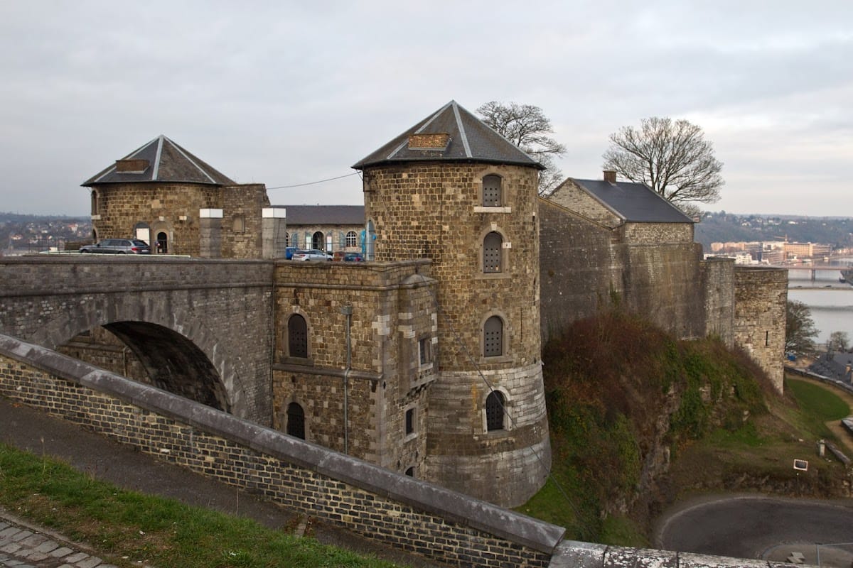
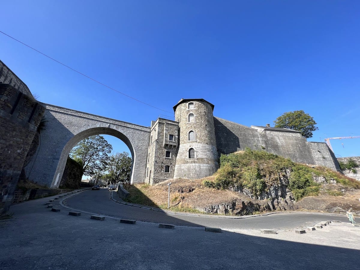
The citadel occupies a rocky spur above the meeting point of the Meuse and Sambre, reaching about 190 meters above sea level. Its area exceeds 80 hectares. The surviving complex is arranged in three principal sectors at different levels: the Donjon, representing the medieval castle and lower sector; Médiane, the intermediate fortified sector; and Terra Nova, the later bastioned sector. Residential areas and extensive woodland surround the historic core, while the site retains underground passages, paths, terraces, bridges, gates, towers, curtain walls, former barracks, and other military structures.
Medieval Donjon
The Donjon developed from the castle of the counts of Namur. A donjon is a fortified keep that served as the principal stronghold and residence of a medieval castle. Probably during the fourteenth century, a second enclosure was built around the keep, along with a circular ditch cut into the rock. The medieval complex included the former comital residence and the collegiate church of Saint Peter of the Castle, both destroyed in the powder-magazine explosion of 1746.
A tower linked to the outer gate system is documented from 1370. Known as the Dessus Bordial, it later became part of the Médiane gateworks. The tower was open toward the castle interior and received artillery loopholes during the fifteenth century. In the sixteenth century, artillery positions were built around it, connecting this older feature to the later defensive system.
Médiane fortifications
The defenses constructed between 1542 and 1559 in front of the medieval castle formed the first substantial citadel later known as Médiane. The name was not applied to this sector until the seventeenth century. Its works included bastioned positions, gates, a bridge, and curtain walls, followed by further rebuilding. The nineteenth-century reconstruction changed the sector again and added a dividing wall between the Médiane gate and the Dutch Bridge. The former officers’ quarters, which had stood there since the seventeenth century, were demolished in 1913. The Médiane gateworks were reconstructed between August 2013 and October 2014.
Terra Nova and later military buildings
Terra Nova was built between 1631 and 1675 as a major bastioned fortification formed by two defensive lines. Vauban rebuilt parts of the fortress and added triangular bastions in 1692. Van Coehoorn installed an underground bakery beside the medieval curtain wall between 1695 and 1698. The Terra Nova guardhouse dates from the second half of the nineteenth century and was reconstructed between March 2013 and May 2014. It now contains exhibition and administrative spaces and a restaurant.
The rebuilding of 1815 to 1830 produced an arsenal, a headquarters building, and barracks designed for up to 1,200 soldiers. The headquarters building is now used by archaeologists of the Public Service of Wallonia, while Terra Nova contains rentable rooms. The former Grand Hôtel de la Citadelle, repaired after its 1914 fire, is used as a training center for hotel professionals.
Transport and landscaped areas
A tramway served the citadel along the Route Merveilleuse from 1910 to 1953. It initially operated as a funicular and, from 1921, used several tunnels and tight curves. A cableway operated from 1957 to 1997, and a new line now links Place Maurice Servais with the summit esplanade. In 1959, a park named for Queen Fabiola was established in the lower part of the fortress with children’s attractions. Together, these later additions form part of the citadel’s modern physical history while the medieval and military structures remain the defining fabric of the site.